International Journal of Scientific & Engineering Research, Volume 5, Issue 9, September-2014 341
ISSN 2229-5518
Water/Land Use Planning of Wadi El-Arish Watershed, Central Sinai, Egypt Using RS, GIS and WMS Techniques
Hossam H. Elewa1, El-Sayed M. Ramadan2, Ahmed M. Nosair3
Abstract
Water crisis in Sinai arid region is a major problem and urgently needs to be solved. W hen flash floods occur, the usual practice is to dispose the flood water into the sea without any benefit, except for a small portion that can be stored in the existing reservoirs. The present work applied an adopted strategy for determining the water/land use priority areas for development depending on the implementation of effective runoff water harvesting (RW H) techniques, side-by-side, with the using of available groundwater. This conjunctive water use gives an optimum pattern for water/land use in Wadi El- Arish watershed. For this sake, the geographic information systems (GIS), remote sensing satellite ETM+ images, watershed modeling system (W MS
8.0© Software) and GIS weighted spatial probability modeling (W SPM) were integrated to recognize the water/land use priority areas for agricultural and
socio-economic activities. Four thematic layers represented by the volume of annual flood, groundwater prospective zones, suitability of geological units for agricultural development, and land slope of the basin were used to build the W SPM model within the ArcGIS 10.1© software platform. A map of water/land use priority areas for development was produced. This map classified the study area into five classes ranked from the very high (1906.49 km2) to very low (2441.56 km2) promising areas for new socio-economic settlements. The present article introduced a genuine proposal to utilize the locations of RW H constructions, i.e. dams, cisterns or surface water reservoirs to optimize the potentiality of sustainable development in the determined promising areas.
Keywords: Wadi El-Arish Watershed, Remote Sensing, Geographic Information Systems, Runoff Water Harvesting, Water/Land Use.
1. INTRODUCTION
Management of water resources in arid regions is the vital factor governing the planning for new developmental activities. This method open the way for new residential communities and agricultural activities. Sinai Peninsula suffers from water scarcity that hampers its development in deserved or fair way. It is located between the Mediterranean Sea to the north, Red Sea to the south and embraced between the Gulf of Suez to the west and Gulf of Aqaba to the east (Fig. 1a). The problem of planning for sustainable development depends mainly on the amount of harvested surface water from flash floods or the available groundwater. However, the main constraint is that the water is harvested in places far from the actual places of use. The water development problem, therefore, should involve transferring water from the areas of harvesting in winter seasons to the high demand areas in summer season, or alternatively storing it in covered cisterns. The most obvious and most common solution to that problem, which is applied in the present work, consists of storing surface water behind dams. Nevertheless, storage of water underground may be a valuable and efficient alternative compared to the surface water storage systems, as it is subjected to less environmental hazards. However, storing water underground is not always systematically
considered when planning water development. The environmental risks of surface dam reservoirs include: (1) high evaporation rates leading to water losses, sometimes exceeding 20% of the average annual runoff, (2) siltation problems, with the equivalent reduction in storage capacity with time, (3) high susceptibility for pollution, (4) distribution of water from the reservoirs may be expensive and requires the construction of costly canals because of the distance between the dam and utilization areas. In contrary, groundwater is not exposed to evaporation; does not suffer from reduction of storage capacity because of siltation; is seldom harmful to environment and offers a natural water distribution up to the user. Depending on either surface or ground water solely is not an effective method or solution, but the conjunctive use provides a harmonic water use policy that combines the advantages of both sources. Conjunctive water use minimizes the undesirable physical, environmental or socio-economical effects and optimizes the water demand/supply balance. Assuming that this required solution is a part of the national policy, several problems need to be carefully addressed before selecting the different options. It also should be taken into consideration that the significant natural recharge of the aquifer systems occurs from the surface runoff and deep percolation of rainfall in the vicinity of the aquifer area.
Here, there will be no need for any additional human
IJSER © 2014 http://www.ijser.org
International Journal of Scientific & Engineering Research, Volume 5, Issue 9, September-2014 342
ISSN 2229-5518
intervention. Artificial recharge of the aquifers can be achieved using three different methods; namely surface water spreading, watershed management (runoff water harvesting) and recharge wells, which maximize the overall water exploitation policy. Wadi El-Arish watershed study area is the largest drainage basin in Egypt. It is located between latitudes 29° 00 and 31° 10` N - 33° 05` and 34° 40` E (Fig. 1b). It debouches into the southeastern littoral zone of the Mediterranean Sea. The watershed covers an area of
21,969 km2, where out of which a nearly 19,000 km2 lies inside Sinai, while the rest area is located in El-Naqab Desert. It drains the central and northern parts of Sinai and comprises about one third of whole Sinai area. It was subdivided into seven sub-watersheds (Fig. 1a). Geologically, the wadi passes through different geological and morphological regions. It upstream from the southern mountainous and rocky terrains of very steep slopes in the south, then goes through the flat sedimentary areas in the middle, and finally ends at the sand dunes near El-Arish City in the north (Shatta and Attia, 1994). The wadi width varies from 5 km in some parts to few meters in other parts.
2. MATERIALS AND METHODS

Four thematic layers represented by Volume of Annual Flood (VAF) (calculated by Finkel's method), groundwater prospectivity (GP), suitability of geological units for land use (SGU), and land slope (LS) were integrated within the ArcGIS 10.0© software platform to perform WSPM modeling for determining the water/land use priority units in Wadi El-Arish watershed. The four themes were converted into raster format and reclassified by the Spatial
Analyst extension tool of the ArcGIS 10.1© software. The Base map of Wadi El-Arish watershed was constructed by using the published and validated maps of the Egyptian General Authority for Civil Survey (EGACS, 1989) with multi-scales, i.e., 1:500,000 (4 sheets), 1:250,000(11 sheets) series. Additional validation and verification was performed using Google Earth maps and Satellite ETM+ images. Land slope of Wadi El-Arish watershed was generated from the Advanced Space-borne Thermal Emission and Reflection Radiometer Digital Elevation Model (ASTER-DEM) with 30 m resolution (http://gdem.ersdac.jspacesystems.or.jp/) (Rabus et al.,
2003) (Fig. 1b). Topographic maps of the EGAS, 1989 were
also used to digitize relevant features and drainage
network to enhance the raw DEM. Volume of annual flood (VAF) m3/year was calculated using watershed modeling systems (WMS 8.0© software) (AQUAVEO, 2008). The volume of annual flood (VAF) was calculated by the Finkel's method (Finkel, 1979) because it gives the less optimistic probability of flood occurrences, which is more reliable to the climate and development conditions of the study area. It is a simple graphical method to determine the probability or frequency of occurrence of annual or seasonal rainfall. Data of rainfall amounts used in the calculation of VAF were compiled from the available records of published and unpublished sources (NSG, North Sinai Governorate, 2006: Environmental assessment of North Sinai, cooperation project between Egypt and Danish Governments. unpublished, 322 pp) and (Elewa and Qaddah, 2011).
Fig. 1. a ETM+ satellite image for Sinai; b Wadi El-Arish ASTER DEM
The Finkel empirical method (Finkel, 1979) uses the following parameters (Eqs. 1 and 2):
Qmax = K1 A
0.67
(1)
1- Peak flood flow (Q max)
Where Q max = Peak flood flows in m3/sec.
2- Volume of annual flood (V) in 1000 cubic meters
IJSER © 2014 http://www.ijser.org
International Journal of Scientific & Engineering Research, Volume 5, Issue 9, September-2014 343
ISSN 2229-5518
V = K 2 A
0.67
(2)
was constructed according to the natural variance between regions (i.e., the SGU and GP) or various ranges (i.e., the
Where A is the area of the basin in km2, and K1 and K2 are
constants depending on 10% probability of occurrence in a
given year (where K1 is 1.58 and K2 is 26.5). Here we used
10% because it is the least optimistic flood amount, which is also very suitable for the climate and development conditions of the study area. In other words, a 10% probability indicates the severity of a flood that is expected to be exceeded on average once in 10 years, i.e. it has a 1 in
10 (10%) chance of occurring in any one year. Groundwater prospectivity was delineated according to the aquifer systems distinguished by the Research Institute for Groundwater (RIGW) hydrogeological map (RIGW, 1999). The suitability of geologic units for land use (SGU) map was constructed from the geologic map of Sinai (CONOCO,
1987). Thematic layers of groundwater prospectively (GP)
and suitability of geologic units for land use (SGU) are
generated in steps, i.e. digitizing, editing, building
topological structure and finally polygonization within the
ArcGIS 10.1© Spatial Analyst Module (Esri, 2007).
3. RESULTS & DISCUSSIONS
The identification of water/land use priority areas for sustainable development in Wadi El-Arish watershed mainly depends on the available water resources from runoff water harvesting and groundwater. When planning for the sustainable use of water and land, it must be taken into account the less optimistic figures for either floodwater or groundwater. Accordingly, this study depends on using the most effective factors suitable for determining the water/land use priority areas in Wadi El-Arish watershed. These factors include: the VAF, which was calculated by the Finkel's method that gives the less optimistic probability of flood occurrence and its volume; the groundwater prospectivity, which is an integral part of the hydrological cycle and reflects the potential groundwater that could be used in conjunction with the harvested runoff water; the suitability of geological units for land use (SGU) and land slope (LS), which govern the mechanical stability of soil cover and runoff velocity. These four factors were identified and digitally mapped as thematic layers. The four thematic layers were converted into raster format and reclassified by the “Spatial Analyst” extension tool of the ArcGIS 10.1© software. Specific weights and ranks were assigned to each theme, while each individual layer class
VAF and LS) (Table 1). Weights and specific ranks of each theme layer were determined according to their magnitude of contribution in determining the water/land use priority areas for sustainable development. Accordingly, each individual theme was normalized by dividing the theme weight by 100. Thus the result of the prioritized map = SGU x 0.4 + VAF x 0.25 + LS x 0.2 + GP x 0.15. Data manipulation included the integration of all thematic layers through running the spatial WSPM model. An output map with several classes reflecting the categories of water/land use priority or promising zones for sustainable development of Wadi El-Arish watershed was resulted. However, not all themes have the same magnitude of contribution in the water/land use prioritization. Some of them highly contribute in water/land use prioritization, but others may have less effect. For example, the factor of SGU is much more effective than the GP. Also, some factors work negatively, such as the LS, while others work positively such as the VAF. The weights were justified based on the magnitude of relation between each layer range of the classified theme. Therefore, the integrated factors in the present work were given the following weights: SGU = 40; VAF = 25; LS = 20; and GP = 15 (Table
1). Accordingly, the theme layer of SGU of Wadi El-Arish
watershed was reclassified from very high to very low
suitability classes for land use. The high class is represented
by wadi deposits, reflecting their higher capability for
agricultural use and can contribute to the storage of flood
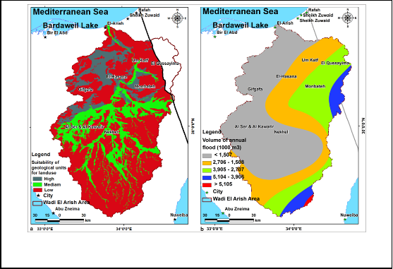
waters to raise the soil moisture needed for agriculture. The moderate and low classes for land use were represented by undifferentiated wadi deposits and hard rocks, respectively (Table 2; Fig. 2a). The geological units were derived from the Conoco, 1987 geological map of Sinai with a scale of
1:500,000. The different lithological units in the map had been delineated and digitized as polygons and then edited and converted into a thematic layer in the ArcGIS 10.1© software (ESRI, 2007). Additional modifications and enhancements of this map were performed using satellite SPOT 4 (acquired in 2011) and Landsat ETM+ (acquired in
2013) images within the ERDAS Imagine 10© Software
platform. Precise correction, filtering, visual tracing and
contrasting for the different lithological units were carried
out. This layer was assigned the weight of 40 in the WSPM
for water/land use prioritization (Table 1).The volume of annual flood (VAF) is very important and effective factor in RWH, consequently in water/land use prioritization. The reclassified map of VAF classified Wadi El-Arish watershed into five classes graded from very high to very low.
Table 1
Weights and ranks assigned to the thematic layers of criteria used in the weighted spatial probability model for water/land use prioritization of Wadi El-Arish watershed.
IJSER © 2014 http://www.ijser.org
International Journal of Scientific & Engineering Research, Volume 5, Issue 9, September-2014 344

ISSN 2229-5518

Theme | | Weight | Layer class and its rank |
Suitability of geological units for water/land use (SGU) | 40 | A: High (Wadi deposits = 8.25); B: Medium (Undifferentiated wadi deposits = 5); C: Low (Hard rocks =1.75) |
Volume of Annual Flood (VAF) (calculated by Finkel, 1979 method) | 25 | Very High (>5105) x 103 m3 = 9; High (5104-3906) x 103 m3 = 7; Moderate (3905-2707) x 103 m3 = 5; Low (2706-1508) x 103 m3 = 3; |
| Land Slope (LS) | 20 | Very Low (< 0.039) = 9; Low (0.04 – 0.044) = 7; Moderate (0.045 – 0.063) = 5; Steep (0.064 – 0.129) = 3; |
Groundwater Prospectivity (GP) | 15 | A: Very Low (Non-aquifer clay) = 1; B: Low (Moderate to low productive extensive aquifers) = 3; C: Moderate (Highly to moderate productive aquifers) = 5; D: High (Locally moderate to Low productive aquifers) = 7; E: Very High (Locally High – Moderate productive aquifers) = 9; |

The very high class in some regions in Wadi El-Arish watershed indicates more flooding possibilities and good chance for implementing agricultural development. The high-very high classes (> 3,906 x 103 m3/y) occur mostly in the extreme northeastern and the southeastern parts of the watershed, while decreasing to the west in the other classes (< 3905 x 103 m3/y) (Table 2; Fig. 2b). This layer was assigned the weight of 25 in the WSPM for water/land use
prioritization. The slope gradient of the drainage basin is a key factor for the selection of water harvesting locations, in order to get the maximum storage capacity in the channel (Elewa et al., 2012 and 2013). It is defined by Horton, 1945; Leopold and Maddock, 1953 as the average slope of the triangles comprising this basin. Land slope map of Wadi El- Arish watershed includes five classes ranging from very low to very steep.
TABLE 2
RANGES OF INPUT CRITERIA USED FOR THE WATER/LAND USE PRIORITIZATION MODEL.


Watershed Model Criteria | Very high | | High | Moderate | | Low | Very low |
Suitability of geological units for water/land use (SGU) | | A | | | B | | C |

IJSER © 2014 http://www.ijser.org
International Journal of Scientific & Engineering Research, Volume 5, Issue 9, September-2014 345
ISSN 2229-5518

Volume of annual flood (VAF) (1000 m3) (by Finkel method)
> 5105 5104-3906 3905-2707 2706-1508 < 1507
Land Slope (LS) (m/m) < 0.039 0.044-0.04 0.063-0.045 0.128-0.064 > 0.129
Groundwater Prospectivity
(GP) E D C B A

The land slope magnitude is inversely proportional to the land or water use potentiality, where the higher the land slope the higher the rates of soil erosion and the lower the land use potential of the land for agriculture (Elewa et al.,
2013). The thematic layer of land slope indicates an increase in value due south in the mountainous terrains in El-Tih and Egma plateau (slope > 0.064) (Table 2; Fig. 3a). Whereas, the land slope decreases in the central (<0.044), which doubles the possibilities of water/land use. The possibility of water/land use is higher in gentle or medium-sloped basins of central-southern and northern sub-watersheds of Wadi El-Arish watershed (0.063-0.045). This layer was assigned the weight of 20 in the WSPM for water/land use prioritization (Table 1).Groundwater prospective units of Wadi El-Arish basin were based on the hydrogeological units published by the RIGW, 1999 map. The constructed map comprises five classes ranging from very low to very high prospective groundwater units. The very low class represents the non-aquifers (clays), whereas the aquifer systems’ productivity were classified from low to moderate classes (for the moderate to low productive extensive aquifers and highly to moderate productive aquifers), to high-very high classes (for the local moderate to low productive aquifers and local highly to moderately productive aquifers, respectively) (Table 2; Fig. 3b). The groundwater availability represents a major factor in land use prioritization. The presence of groundwater affects the land use, where it represents an important alternative to surface water, especially during the arid rainless seasons. This layer was assigned the weight of 15 in the WSPM for water/land use prioritization (Table 1).
3.1. Weighted spatial probability modeling (WSPM) for
water/land use prioritization.
After defining theme requirements for water/land use prioritization mapping, the multi-criteria decision support layers are to be converted into a data coverage for easier data storage and manipulation. The ranges of these input criteria (layers) used in the construction of the WSPM for generating the water/land use map are given in Table 2.
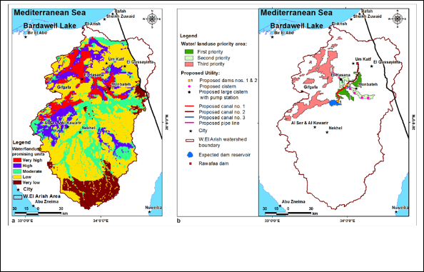
VAF, LS, and GP criteria have five classes ranging from very low to very high. Whereas, the SGU have three virtual classes as described in Table 1. Integration of these criteria in the WSPM generated a comprehensive water/land use map, which will determine the efficient sites suitable for the installment of micro-catchment agriculture depending on the available water resources, with a number of classes. Weights and rates were assumed and optimized for the WSPM for water/land use prioritization depending on the experience or judgments of the authors and the opinions of experts in the previous similar works on RWH potentiality mapping (i.e., qualitative methods of Adiga and Krishna Murthy (2000); Anbazhagan et al. (2005), and Elewa and Qaddah (2011); Elewa et al. (2012 and 2013), in addition to the geostatistical normalization and cross-validation (quantitative methods) within the ArcGIS 10.1© platform before running the model (Isaaks and Srivastava,1989).The cross validation is a statistical procedure for testing the quality of a predicted data distribution and the model results. In cross validation, a piece of data whose value is known independently is removed from the dataset and the rest of the data is used to predict its value. Full cross validation is done by removing, in turn, each piece of data from the dataset and using the rest of the data to predict its value. The weights and rates were determined depending on the magnitude of contributions between each layer range of the WSPM classified layers. An arithmetic overlay approach built up within the ArcGIS 10.1© Spatial Analyst Model Builder was carried out for performing the water/land use prioritization map of Wadi El-Arish watershed. This overlay processing manipulates both continuous and discrete grid layers and the derived data are continuous grid data layer. Accordingly, an output map of water/land use promising units with five classes ranging from very low to very high was produced (Fig. 4a). The spatial distribution of these classes relative to the total area studied is: 11.11 % (Very low), 49.36 % (Low), 17.92 % (moderate), 12.91 % (high), and 8.67 % (very high) promising units for water/land use (Fig.4a; Table3).
IJSER © 2014 http://www.ijser.org
International Journal of Scientific & Engineering Research, Volume 5, Issue 9, September-2014 346
ISSN 2229-5518
Fig. 2. GIS thematic layers used in the water/land use prioritization model: a) Suitability of geological units for landuse (SGU); b) Volume of annual flood (VAF)
Fig. 3. GIS thematic layers used in the water/land use prioritization model: a) Land slope (Ls); b) Groundwater prospectivity (GP)
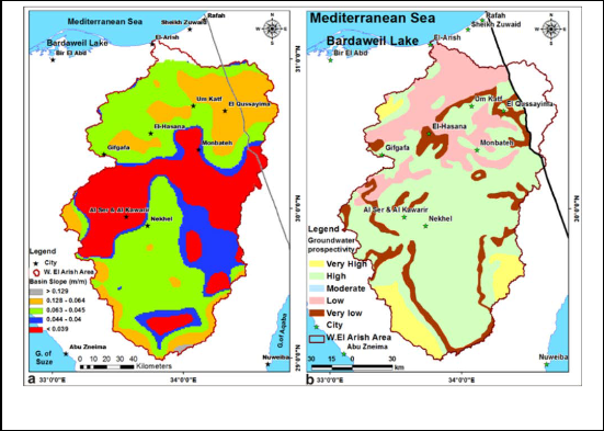
TABLE 3
WATER/LAND USE PRIORITY CLASSES AND THEIR AREAS.

Water/landuse promising (priority) units for sustainable development

IJSER © 2014 http://www.ijser.org
International Journal of Scientific & Engineering Research, Volume 5, Issue 9, September-2014 347

ISSN 2229-5518
Promising Class Very Low Low Moderate High Very High
Area (Km2) 2441.56 10845.90 3938.35 2837.00 1906.49
Area (% of total study area)
Total study area: 21,969 Km2
11.11 49.37 17.93 12.91 8.68

3.2. Water/land use master plan of Wadi El-Arish watershed
Water/land use master plan of Wadi El-Arish watershed will be used to project the most promising areas for future agricultural or urban installments. Additionally, the map comprises the main necessary engineering constructions and utilities, which are required as infrastructure for these installments (Fig. 4b).The most promising areas for water/land use are the regions which were assigned the class of very high” that was elucidated by Fig. 4a. This promising area is about 1906.49 km2, which constitutes about 8.68% of the total watershed area. This promising area was subsequently subdivided into three priority areas according their relative location to the planned RWH systems (i.e., dams, reservoirs and canals). The first priority area consists of two regions with areas of 163.01 km2 and
123.65 km2. These areas occur around the proposed canals nos.1 & 2, which are connecting the proposed dams nos.1 &
2 with the old Rawafaa Dam. The required surface water for the development of these regions will be from the stored harvested water upstream the proposed dams, which will be discharged through the proposed canals to supply surface water to implement micro-catchment agriculture. In conjunction, groundwater will provide a supplemental source of water for irrigation during the rainless seasons. The second priority areas consist of two regions. The first (eastern one) region has an area of 141.96 km2, which will depend on the groundwater in conjunction with the harvested surface runoff water. Therefore, four cisterns were proposed for construction, with a capacity of 10,000 m3 for each, with dimensions of 200 X 200 X 2.5 m to store the harvested surface runoff water at different locations throughout these regions. The second region (western one) has an area of 110.43 km2, which will depend in its agriculture on the stored water upstream the proposed dam no. 2, where a proposed constructed open channel with a length of 6 km starting from the spillway of the upstream reservoir of proposed dam no. 2 to convey water during the
flooding seasons and to fill-up the large cistern shown in
Fig. 4b, which occur at the farthest point of this area. For future development, the third priority regions have a total area of 1390.64 km2, where a pipeline with a length of 15 km and 0.4 m diameter, starting from the proposed large cistern will be constructed. Water will be lifted seasonally after the proliferous flooding episodes through a water pumping station installed on the proposed large cistern to convey water to the regions of the third priority. This priority area is the farthest regions from the constructed water harvesting system, so it will depend mainly upon groundwater in its agricultural development.
PROPOSED CONSTRUCTIONS FOR WATER/LAND USE
MASTER PLAN IN WADI EL-ARISH WATERSHED (FIG.
4B).
1. Two proposed dams to store surface water, which have a total capacity of 525,000 m3 for the proposed dam no.1 and
250,000 m3 for the proposed dam no. 2.
2. Two proposed canals to convey water from surface reservoirs; the first canal from the proposed dam no. 1 to the proposed dam no. 2, and the second canal from proposed dam no. 2 to El-Rawafaa dam with a length of
36.47 and 42.77 km, respectively.
3. Four cisterns of 10,000 m3 to store surface water through the first (eastern) region of the second priority areas.
4. An open impermeable channel (Canal no. 3) with a length of 6 km to convey water from the upstream reservoir of proposed dam no. 2 to the second region of the second priority areas.
5. A large cistern to be installed at the end of the last proposed open channel to store the harvested water of the flooding seasons for subsequent uses.
6. A water pumping station to be installed on the proposed
large cistern at the start of the proposed pipeline to pump water to the far regions of the third priority areas.
7. A pipeline with a length of 15 km and 0.4 m diameter to convey the pumped water from this proposed pump station to the regions of the third priority areas.
IJSER © 2014 http://www.ijser.org
International Journal of Scientific & Engineering Research, Volume 5, Issue 9, September-2014 348
ISSN 2229-5518
Fig. 4. a) Weighted Spaial Probability Model (W SPM) map showing the Water/Land use priority (promising) areas for sustainable development , b) Water/Land use master plan for Wadi El-Arish watershed
4. SUMMARY AND CONCLUSION
A new water/land use master plan for Wadi El-Arish watershed was proposed depending on the application of conjunctive surface water/groundwater use policy. This master plan was constructed according to the expected harvested runoff water and the actual groundwater prospectivity of the area studied. Integration of remote sensing, geographic information systems, Watershed Modeling Systems (WMS 8.0© Software), and weighted spatial probability modeling (WSPM) for water/land use prioritization was found to be highly effective in producing such a new Water/Land Use Master Plan for Wadi El-Arish watershed, for the first time. Four thematic effective layers were integrated within the ArcGIS 10.1© software platform to construct the WSPM model. These thematic layers include the volume of annual flood (VAF), groundwater prospectivity (GP), suitability of geological units for land use (SGU), and land slope (LS). The resulted map classified the study area into five promising units ranging from very low to very high. The most suitable areas for water/land use are the regions which were assigned the “very high” class. This promising area is about 1906.49 km2, which constitutes about 8.67% of the total watershed area. This promising area were subsequently subdivided into three priority areas according to their relative location to the planned runoff water harvesting (RWH) systems (i.e., dams, reservoirs and canals). The present work suggested two dams, five cisterns, three canals and pipe lines for
implementing the RWH system in conjunction with the available groundwater, for the sustainable development of Central Wadi El-Arish area.
5. ACKNOWLEDGEMENT
The authors wish to express their great gratitude to the Science & Technology Development Fund (STDF) for kindly funding and supporting the present project. Deep gratitude is also dedicated to the National Authority for Remote Sensing and Space Sciences (NARSS) for providing the facilities needed for conducting the present work.
6. REFERENCES
Adiga, S., and Y.V.N. Krishna Murthy, 2000. Integrated sustainable development of land and water resources using space technology inputs. Space Forum 5:179–202.
Anbazhagan S., S.M. Ramasamy and S. Das Gupta, 2005. Remote sensing and GIS for artificial recharge study, runoff estimation and planning in Ayyar basin, Tamil Nadu, India. Environ Geol 48:158–170. doi: 10.1007/s00254-005-1284-4.
AQUAVEO Water modeling solutions, 2008. Support forum for sub- watershed modeling system software (WMS) www.aquaveo.com. Conoco (Continental Oil Company), 1987. Geological Map of Egypt (Scale 1: 500,000). Conoco Inc. in Collaboration with Freie Universitat Berlin, ISBN 3-927541-09-5.
EGACS, 1989. Egyptian General Authority for Civil Survey. Topographic sheets, scales 1:500000-1:250000.
Elewa, H.H. and A.A. Qaddah 2011. Groundwater potentiality
mapping in the Sinai Peninsula, Egypt, using remote sensing and GIS-
IJSER © 2014 http://www.ijser.org
International Journal of Scientific & Engineering Research, Volume 5, Issue 9, September-2014 349
ISSN 2229-5518
watershed-based modeling. Hydrogeology Journal, 19: 613-628. (DOI
10.1007/s10040-011-0703-8).
Elewa, H.H., A.A. Qaddah and A.A. El-Feel 2012. Determining Potential Sites for Runoff Water Harvesting using Remote Sensing and Geographic Information Systems-Based Modeling in Sinai. American Journal of Environmental Sciences, Science Publications, USA, 8: 42-55. Elewa, H.H., E. M. Ramadan, A. A. El-Feel, E. A. Abu El Ella, and A. M. Nosair, 2013. Runoff Water Harvesting Optimization by Using RS, GIS and Watershed Modelling in Wadi El-Arish, Sinai. Inter. J. Engi. Res. & Tech., 2: 1635- 1648. ISSN: 2278-0181.
ESRI, 2007. ArcGIS 9.2® Software and user manual. Environmental
Systems Research Institute, Redlands, California 92373-8100, USA. http://www.esri.com.
Finkel, H.H., 1979. Water Resources in Arid Zone Settlement, A Case
Study in Arid Zone Settlement, the Israeli Experience, G. Colany ed., Pergamon.
Horton, R.E., 1945. Erosional development of stream and their drainage basin. Hydrogeological approach to quantitative morphology. Bull. Geol.Soc. Am., 56: 275-370.
Isaaks, E.H. and R.M. Srivastava, 1989. An introduction to applied geostatistics. Oxford University Press, New York, 561 pp.
Leopold, L.B. and T. Maddock, 1953. The hydraulic geometry of stream channels and some physiographic implications: U.S. Geol. Survey Prof. Paper 252, 52 p,
Rabus, B., M. A. Eineder and R.R. Bamler, 2003. The shuttle radar
topography mission- a new class of digital elevation models acquired by space-borne radar, Photogram. Rem. Sens., 57: 241-262.
RIGW (Research Institute for Groundwater), 1999. Hydrogeological
map of Egypt. Scale 1:2000000 2nd edn. National Water Research Center (NWRC), Ministry of Public Works and Water Resources, Cairo.
Shatta, A. and F. Attia, 1994. Environmental aspects of water
harvesting. In: FAO, Water harvesting for improved agricultural
production. expert consultation, Cairo, Egypt. 21-25 Nov. 1993, p. 257-
270, FAO, Rome.
Singh, S. and M.C. Singh, 1997. Morphometric Analysis of Kanhar
River Basin. National Geographical J. India., 43: 31-43.
Authors
1 Water Resources Department, National Authority for Remote Sensing & Space Sciences (NARSS), Cairo, Egypt. elewa.hossam@gmail.com
2 Water Engineering Department, Faculty of Engineering, Zagazig University (ZU), Zagazig, Egypt.
smokhtar@zu.edu.eg
3 Geology Department, Faculty of Science, Zagazig University (ZU), Zagazig, Egypt.
Ahmed_nosair2003@yahoo.com
IJSER © 2014 http://www.ijser.org