International Journal of Scientific & Engineering Research Volume 2, Issue 9, September-2011 1
ISSN 2229-5518
Recent geomorphological changes in Ebrié
lagoon, Côte d’Ivoire, West Africa
Monde Sylvain, Toure Mamadou, N’guessan Yao Mathieu
Abstract - Ebrie Lagoon has been under heavy pressure (natural forcing and antropogenic) since the digging of the Vridi Canal in 1950, which made the circulation of water more complex. Morphological changes in the lagoon between 1962 and 1998 were assessed from bathymetric maps. The sedimentary budget of the estuarine bays of Abidjan was estimated at 950 m³ over the past 50 years.
Index Terms - Hydrodynamics, Morphology, Sedimentation, Ébrié Lagoon
—————————— ——————————
1 INTRODUCTION
Because of their location and ubiquity, estuaries play a major role all over the world in exchanges between lands and oceans. Several physical and chemical processes occur in these environments, which depend on the long residence time of water, suspended sediment and associated contaminants [1]. In comparison to their temperate counterparts, sediment processes in tropical estuaries, in particular in Africa [2], are poorly understood [3, 4].
The Ebrié estuary, Côte d’Ivoire, is a good example of a
tropical environment. However, human activities such as fishing, forestry, sand extractions are intense in the estuary and in the surrounding wetlands. In addition, the loss of such coastal plain areas due to flooding and erosion associated with climatic and eustatic sea level rise is of vital ecological concern. Human interest in this lagoon dates back to the opening of Vridi’s channel for navigation in
1950. Economic, natural and social activities are often contradictory and their competition assumes that a balance
————————————————
Author name : Monde Sylvain, Professor of marine geology in University of Cocody, Abidjan, Côte d’Ivoire, 22 BP 528 Abidjan 22. E-mail: atteson@gmail.com
Co-Author name 1: Toure Mamadou, Doctor in geomorphology in University of Cocody, Abidjan, Côte d’Ivoire, 22 BP 528 Abidjan 22. E- mail: touremmd@yahoo.fr
Co-Author name 2: N’guessan Yao Mathieu, Doctor in geochemistry in University of Cocody, Abidjan, Côte d’Ivoire, 22 BP 528 Abidjan 22. E- mail: nguessym@yahoo.fr
can be maintained. Indeed, the Ébrié lagoon is a heterogeneous and fragile ecosystem where hasty and ill- considered intervention can lead to serious or even irreversible damage of the environment. Furthermore, this new access to the sea has greatly changed the movement of bodies of water, in particular, causing the closure of the mouth of the Comoé to Bassam. The salinity of the water decreased sharply in the eastern area of the lagoon, where a proliferation of floating vegetations is causing a partial anoxia and smelly pollution. The quality of the waters of the lagoon is therefore a recurring problem since fishing is traditionally an important food source for local populations. Outside areas under marine influence, differences in temperature and salinity between background and surface appear to be quite low. The lagoon may therefore be regarded as a fairly well homogenized environment. All these hydrodynamic and anthropogenic forcing on the Ébrié lagoon arise some problems (device management, channels management and maintenance, dissemination of pollutants, accumulation of pollutants, understanding of the movement of bodies of water in view of for new facilities (harbour extension).
1. 1 State of knowledge
Earlier studies on the Ébrié lagoon focus on delivery suspended sediment particles but also the plankton by
wind [5] and biological productivity. Furthermore, some
IJSER © 2011 http://www.ijser.org
International Journal of Scientific & Engineering Research Volume 2, Issue 9, September-2011 2
ISSN 2229-5518
measures of the circulation of water were conducted to assess the contribution of River [6]. To our knowledge, very little research by modelling was conducted in the Ébrié lagoon due to a lack of bathymetric and current data [7]. Data for the quantification of the hydro-sedimentary settings are rare and mostly very short-term. To study the hydro-sedimentary processes in the lagoon, it is necessary to acquire new data. These data will be analyzed for a
better understanding of the process, but also to validate
and calibrate models, hence the need for continuous long- term measurements.
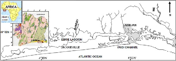
The aim of this paper is to determine the hydro-dynamism
of Ébrié lagoon in the long-term sedimentary evolution of the coastal environment (Fig. 1). This study also contributes to a better understanding of such coastal tropical systems, especially in Africa which has some of the least studied hydrological systems in the world [2].
2 MATERIALS AND METHODS
2.1 Current analysis
Fig. 1 : Ebrié lagon in Côte d’Ivoire
above the current-meter, which were counted positive and negative below [8].
A Doppler Effect current-meter (CM12 Anderaa) was used to determine the flow rate in a water column according to different defined depths and during a tide cycle. Furthermore, it gave the water level variation in real time and in the stream direction. The interpretation, measured
the streams speeds of the water level during water rise,
2.2 Sedimentary budget
The bathymetric maps of the bay of Abidjan (Fig. 2 & 3) were georeferenced. The superposition of the maps allowed obtaining a space evolution of the estuary of the Ébrié lagoon.
IJSER © 2011 http://www.ijser.org
International Journal of Scientific & Engineering Research Volume 2, Issue 9, September-2011 3
ISSN 2229-5518
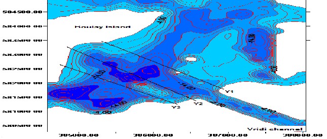

Fig. 2 : Bathymetric map of Abidjan bay [9]
Fig, 3: Extract of the bathymetric map of Abidjan’s bay 1952 - 1962 [10]
The elevation of a profile in relation to another (overlay) made from the same site reflects the volume of sediment moved. The calculation of volume result from the plotting of surface delimited between the superimposed profiles.
The product of this surface and the half-distance between
the profiles makes it possible to estimate the volume of sand deposited or eroded (Fig. 4). That is to say : V = S x D (m) with V (volume of eroded or fattened sand (m3) and S (eroded or fattened surface in m²) linear or S =Σ dx).
IJSER © 2011 http://www.ijser.org
International Journal of Scientific & Engineering Research Volume 2, Issue 9, September-2011 4
ISSN 2229-5518
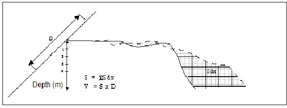
Fig. 4 : Method of calculation of volumes of eroded or fattened sands
3 RESULTS AND DISCUSSION
3.1 Sedimentary dynamics of the estuarine bays Analysis of depth profiles, made from the radial O(Old) and Y(Young) respectively from the bathymetrics maps Shom [10] and Paa [9], shows the evolution of the lagoon-
bed, in the last fifty year, in the Abidjan estuarine zone.
Profile O1 and Y1 has a concave morphology (Fig. 5). The average bottom passes from 7 to 10 m. Moreover the recent transect (Y1) is below O1. But anthropogenic action is not to be neglected because it is an area of navigation and some dredging takes place there [8, 11; 12; 13; 14].
Radial (X in UTM - m)
385400 385450 385500 385550 385600 385650 385700
-1
-3
-5
-7
-9
-11
O1 Y1
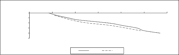
Fig. 5 : Concave morphology in Abidjan’s harbor
Figure 6 presents transects in which the lagoon-bed varies from 0 to 13 m and a convex morphology. The average
depth goes up from 13 to 12 m. Transect O2 is below that of
1999 (Y2). That would be the result of an accretion in the channels. It is noted that erosion occurs on the banks and
the particles settle in the channels; hence the deposit [8].
IJSER © 2011 http://www.ijser.org
International Journal of Scientific & Engineering Research Volume 2, Issue 9, September-2011 5
ISSN 2229-5518
Radial (X in UTM - m)
384600 384700 384800 384900 385000 385100 385200 385300
0
-2
-4
-6
-8
-10
-12
-14
O2 Y2
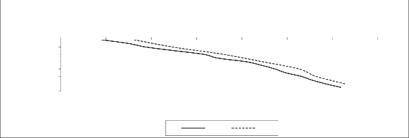
Fig. 6 : Convex morphology in lagoon-bed of Abidjan harbor
Transect O3 and Y3 (Fig. 7) present a mixed dynamism. An erosion of the banks in the first five meters followed an important accretion of the lagoon’s bottom with a stability
point at -6 m. These phenomena are appreciated in
sedimentary dynamics terms. The analysis of table shows that for an average depth of 12.5 m and for a sedimentary surface of 75 m², the sedimentary budget is 950 m³. The
sedimentation celerity is 6 cm/yr and 8 cm/yr for erosion.
384600 384800 385000 385200 385400 385600 385800 Radial (X in UTM - m)
-2
-12
-22
-32
-42
-52
O3 Y3
3.2 Comparative studies
3.2.1 Arcachon lagoon (France)
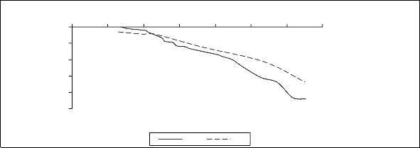
Fig. 7 : Intermediate morphology in Abidjan’s harbor
3.2.2 Evolution of Kounkouré estuary (West Africa)
The estuary of Kounkouré is another example of
A similar study, using bathymetric surveys to assess sedimentary budget, has been done in the Arcachon lagoon. The Arcachon lagoon is located on the Atlantic coast of France, facing the wave-dominated shelf of the Bay of Biscay. It is a mesotidal semi-enclosed environment of about 160 km2. The sediment budget of the Arcachon lagoon was computed by subtracting the 1865 bathymetric map from that of 2001. The computed volume difference is low (−9,9±35×106 m3 in 136 yrs) and is the result of the balance between erosion and accretion that occurs within
tidal channels and tidal flats, respectively [15].
morphological evolution in tropical environment. The estuary of Konkouré throws (casts) itself into the Atlantic Ocean, in the northwest of Conakry, the Guinean capital. This estuary, in the morphology close to a delta, consists of two arms. The first one, the main arm of Konkouré, is the arm the West separated in two by an island in its mouth. It emerges however from an observation of both maps (on
1951 and 1992) that the system seems to have evolved morphologically since 1951, the networks of channels being similar on both maps (Fig. 8).
IJSER © 2011 http://www.ijser.org
International Journal of Scientific & Engineering Research Volume 2, Issue 9, September-2011 6
ISSN 2229-5518
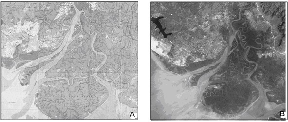
Fig. 8: Evolution of Konkouré estuary (A : The map IGN of 1951, B : SPOT image 1992 [16].
3.2.3 Morpho-sedimentological of San Pablo Bay
(USA)
Analysis of a series of historical bathymetric surveys has revealed large changes in morphology and sedimentation from 1856 to 1983 in San Pablo Bay (California). In 1856, the morphology of the bay was complex, with a broad main channel, a major side channel connecting to the Petaluma River, and an ebb-tidal delta crossing shallow parts of the bay. In 1983, its morphology was simpler because all channels except the main channel had filled with sediment and erosion had planed the shallows creating a uniform gently sloping surface [17]. The timing and patterns of geomorphic change and deposition and erosion of sediment were influenced by human activities that altered sediment delivery from rivers.
4 CONCLUSION
This work presents how from bathymetric maps, we can assess to geomorphic and morphological changes of a lagoon. Here we study the Ebrié lagoon. The average depth, in the lagoon-bed, goes up from -13 to -12 m. That would be the result of an accretion in the channels. It is noted that erosion occurs on the banks and the particles settle in the channels; hence the deposit. An others zone present a mixed dynamism. An erosion of the banks in the first five meters followed an important accretion of the lagoon’s
bottom with a stability point at -6 m. The sedimentation
celerity is 6 cm/yr and for erosion, it’s 8 cm per year in the
last fifty year.
REFERENCES
[1] DYER K.R, 1995. Sediment Transport Processes in Estuaries. Geomorphology and Sedimentology of estuaries. Developments in Sedimentology 53, edited by GME Perillo.
423-449.
[2] KITHEKA J.U., OBIERO M., NTHENGE P. 2005. River discharge, sediment transport and exchange in the Tana Estuary, Kenya. Estuarine, Coastal and Shelf Science, 63, pp.455-468
[3] BRYCE S., LARCOMBE P., RIDD P.V. 1998. The relative importance of landward-directed tidal sediment transport versus freshwater flood events in the Normanby River estuary, Cape York Peninsula, Australia. Marine Geology, 149, 55-78
[4] BRYCE S., LARCOMBE P., RIDD P.V., 2003. Hydrodynamic and geomorphological controls on suspended sediment transport in mangrove creek systems, a case of study: Cocoa Creek, Townsville, Australia. Estuarine, Coastal and Shelf Science, 56, 415-531.
[5] ARFI R., GUIRAL D., BOUVY M. 1994. Sedimentation modified by wind induced resuspension in a shallow tropical lagoon (Côte d’Ivoire). Netherlands Journal of Aquatic Ecology
28(3-4) 427-431.
[6] ABE J., BAMBA S.B., BAKAYOKO S., CISSOKO S.
1996. Note sur l'hydrologie de l'estuaire du Comoé à Grand- Bassam (Côte d'Ivoire). Agronomie Africaine, 8(3) : 201-212.
[7] GUIRAL D., FERHI A. 1992. Hydrodynamics of Ebrié
lagoon as revealed by a chemical and isotopic study. Hydrobiologia 245: 65-74.
IJSER © 2011 http://www.ijser.org
International Journal of Scientific & Engineering Research Volume 2, Issue 9, September-2011 7
ISSN 2229-5518
[8] MONDE S 2004. Etude et modélisation hydrodynamique de la circulation des masses d’eau dans la lagune Ébrié (Côte d’Ivoire). Thèse Doctorat d’État, Université Cocody, 325p.
[9] PAA- Port Autonome d’Abidjan 1994. Extrait de
munites de sonde de la rade portiaire d’Abidjan Rapport interne 1 carte
[10] SHOM -Service Hydrographique et Océanographique de la Marine française 1952. Extrait de la carte bathymétrique de la lagune Ébrié, Édition n°3, Échelle : 1/2000
[11] TASTET JP, CAILLON L, SIMON B 1985. La dynamique sédimentaire littorale devant Abidjan : impacts des aménagements. Contribution à la compréhension des phénomènes d'érosion et de sédimentation. Université de Côte d’Ivoire-Port Autonome d’Abidjan, 39p.
[12] ABE J, AFFIAN K 1993. Morphology and touristic
infrastructures of Côte d’Ivoire. In Tourisme vs Environment:
the case for coastal areas. Wong Edition: 99-108.
[13] PAA –Port Autonome d’Abidjan 1994. Les conséquences de l’ouverture du canal de Vridi sur l’évolution géomorphologique du littoral. 8ème journée géographique de Côte d’Ivoire : «Économie portuaire et structuration de l’espace national : Espaces littoraux et vie marine», Rapp. Inter., 20p.
[14] MONDE S, AFFIAN K, AMANI EM, WOGNIN V,
COULIBALY SA, AKA K 2007. Analyse temporelle de l’hydrodynamisme du secteur estuarien de la lagune Ébrié à Abidjan (Côte d’Ivoire). Impact de la variabilité climatique, Revue CAMES – Série A, Vol. 05 : 32-38
[15] ALLARD J., CHAUMILLON E., FÉNIÈS H. 2009. A
synthesis of morphological evolutions and Holocene stratigraphy of a wave-dominated estuary: The Arcachon lagoon, France. Continental Shelf Research, Vol.29, Iss. 8 : 957-
969
[16] CAPO S 2006. Hydrodynamique et dynamique sédimentaire en milieu tropical de mangrove, Observations et modélisation de l’estuaire du Konkouré (Guinée). Thèse Doctorat, Université Bordeaux I, 247p.
[17] JAFFE B.E., RICHARD E.S., AMY C.F. 2007.
Anthropogenic influence on sedimentation and intertidal mudflat change in San Pablo Bay, California: 1856–1983. Estuarine, Coastal and Shelf Science, Vol.73, Iss. 1-2 : 175-187
IJSER © 2011 http://www.ijser.org