International Journal of Scientific & Engineering Research Volume 4, Issue 2, February-2013 1
ISSN 2229-5518
Lithostructural characterization of the auriferous shear zone of Parc-Sou (Hana-Lobo Region in the South-West of Ivory Coast, West Africa)
Gbele OUATTARA, Gnammytchet Barthélemy KOFFI, Alphonse Kouakou YAO
Abstract— The auriferous shear zone of Parc-Sou (south-west of Ivory Coast, West Africa) is a major lineament. It is confirmed from the interpretation of a Landsat Thematic Mapper (TM) image, ground magnetic surveys and field data. This mylonitic area subdivides the Parc- Sou sector in two lithological entities. In the western district, we have schists formations, sedimentary and volcano-sedimentary origin. In the eastern district, the formations are granitic and gneissic.
The study of structures and quartz veins, shows that the mineralization is associated with the second ductile phase of the Birimian D2 (2400-1800 My), which affects the schists. The mineralization is, however, absent in the granitic and gneissic formations. We can say that the mineralization is related not only to structural and hydrothermal processes, comtemporary to the D2, but also to lithological contrast.
Index Terms— gold bearing shear zone, Ivory Coast, lineaments, lithological contrast, magnetic anomalies, Parc-Sou, structural and hydrothermal mineralization.
1 INTRODUCTION
—————————— ——————————
ocated in the south-western Ivory Coast, with an area of
2126 km2, the region of Hana-Lobo belongs to both the
SASCA zone (SASsandra CAvally; [1]). It corresponds to
the "transition" between the Archean and the Paleoproterozoic
[2], [3].
The geological formations in the region of Hana-Lobo (fig-
ures 1 and 2) are composed of schists, micaschists, rhyolites, amphibolites, metamorphic tuffs and various granites, gran- odiorites, gneisses and gabbros.
On the local scale of Parc-Sou sector, we have a major geo- logical structure characterized by the Hana-Lobo fault zone (or Soubré fault) with NNE-SSW orientation [4]. It separates two major geological units: 1) at the west of Hana fault, the formations are oriented NNE-SSW. These Birimian formations consist mainly of clastic sediments showing alternating argil- lites, arenites and arkoses metamorphosed into schists; 2) at the east, the formations are mainly granitic and gneissic (syn- tectonic granites, granitic gneiss, gabbros, post-tectonic two- mica granites with garnet and sillimanite).
Geological formations have been affected by two major tec-
tonic events D1 and D2 [5], causing the shear-rich gold miner-
alization.
The first phase of deformation (D1) is characterized by the
S1 cleavage, subparallel to the sedimentary layering S0.
The second phase (D2) consists of S2 cleavage, millimeter to
centimeter isoclinal folds.
This part of the paleoproterozoic domain in the West Afri- can Craton, located at the east of the Sassandra fault (figure 1), has given many results of exploration works carried out by Bolgarski [2] and somme companies as SODEMI, ANMERCO- SA and MANAGEM. These works highlighted a gold deposit estimated at 6.8 tonnes, where the Parc-Sou area constitutes the most interest identified.
It is question, in this work, to characterize the metallotects (lithology and structures), the origin of this deposit and make a comparison with those of other gold bearing zones in the world.
————————————————
Gbele OUATTARA, Departement of Earth Sciences and Mineral Re- sources, Institut National Polytechnique Félix Houphouët-Boigny Yamous- soukro (Côte d'Ivoire, Ivory Coast). E-mail: gbele.ouattara@yahoo.fr
Gnammytchet Barthélemy KOFFI, Departement of Earth Sciences and
Mineral Resources, Institut National Polytechnique Félix Houphouët-
Boigny Yamoussoukro (Côte d'Ivoire, Ivory Coast).
Alphonse Kouakou YAO, Departement of Earth Sciences and Mineral
Resources, Institut National Polytechnique Félix Houphouët-Boigny Ya-
moussoukro (Côte d'Ivoire, Ivory Coast).
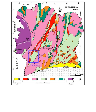
Fig. 1. Simplified geological map of Ivory Coast with the location of Hana-Lobo area. 1: sediments of Cretaceous to present; 2: two-micas granites; 3: indifferentiated granitoids and gneiss; 4: metasedimentary basins; 5: calc-alkaline granitoids; 6: volcanic and volcano-sedimentary formations; 7: archean formations (migmatites, gneiss, granulites, charnokites); 8: faults.
IJSER © 2013 http://www.ijser.org
International Journal of Scientific & Engineering Research Volume 4, Issue 2, February-2013 2
ISSN 2229-5518
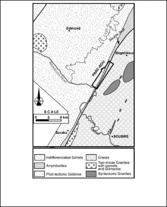
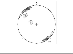
Fig. 3. Stereographic poles of cleavages and gneissosity, Wulf canvas, lower hemisphere.
Fig. 2. Simplified geological map of the region of Hana-Lobo
(Modified after ANMERCOSA, 1998, unpublished).
2 MATERIAL AND METHODS
The methodology of this study consists of:
1. A synthesis of regional and local geology. This synthe-
sis will permits to better understand the geological
framework of Hana-Lobo region and Parc-Sou in par-
ticular.
2. A structural study, including lineaments and field data.
The analysis of a Landsat TM image (196-056 from 2000
in UTM projection, WGS 84, kilometric coordinates)
will clarify the localization and the type of some fault
zones in relation to the geological substratum. Field da-
ta permits us to better appreciate the relationships be-
tween the main mineralized structures or not.
3. A study of magnetometer surveys that will give the
main areas of anomalies and their relations to geologi-
cal structures and formations.
3.2 Analysis of lineaments in the region of Hana-Lobo
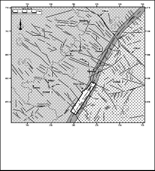
Analysis and interpretation of the Landsat TM image subdi- vide the study area into three zones (figure 4):
Zone 1 corresponds to the ductile shear zone of the Hana fault or the Soubré fault (FSo). The lineaments are discontinu- ous. Two main directions appear: NE-SW (N30° to N45°) in the northern part and NNE-SSW direction (N15° to N20°) in the south. This fault is crosscuted by the fault of Maboguhé East (FMaE) with N130° direction and sinistral strike-slip movement. The Hana fault is a sinistral reverse fault according to Lemoine [6], which would have allowed the rise of the SE compartment (consisting of deep gneiss) on schists and micas- chists of the western zone. Near this accident, the cleavage and the gneissosity, with NNE-SSW direction, are slightly slope and gradually picking up.
Zone 2 is located at the west of the Hana fault. This area is strongly influenced by a river system like "fish bone" type, where central part is occupied by the Lobo river. Lineament structures show a dominant N120° to N140° directions.
3 RESULTS
3.1 Lithological analysis of Parsc-Sou
The past works where completed by new field observations. It appears from these works that the Parc-Sou sector is character- ized by two different lithologies.
At the west of the Hana fault zone, the formations are mainly schistose (sericite and chlorite schists, quartz-feldspar schists, mica schists, tuffs and feldspar sandstones) with NNE- SSW direction and a strong dip to southeast (figure 3).
To the east, the formations are granite, gneiss and amphibo- lo-pyroxenites.
IJSER © 2013 http://www.ijser.org
Fig. 4. Interpretation with lineament network and circular structures in the region of Parc-Sou; from Landsat TM image, composite color (196-056 from 2000 in UTM projection, W GS
84, coordinates kilometer). FBa: Bagoléoua fault; FSo: Sou-
bré or Hana fault; FPe: Petigoa fault; FMaE: Maboguhé East fault.
International Journal of Scientific & Engineering Research Volume 4, Issue 2, February-2013 3
ISSN 2229-5518
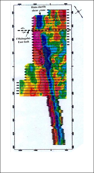
Zone 3 is located at the east of the Hana fault. We can ob- serve a "fish bone" network, but less marked. The lineaments have variable directions: N30°, N55°, N75°, N90°, N125° to N150°. The circular structures are clearly present.
3.3 Geology and mineralization of Parc-Sou
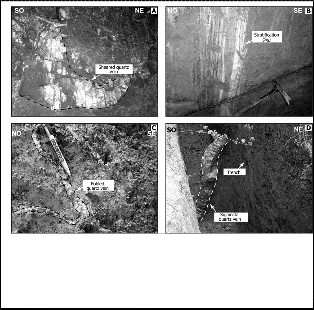
The mineralization is mostly related to tourmaline-quartz veins (mainly located in zone 1) and immediate contact areas of the country rock (schists/saprolite). This is a structural and hydrothermal type mineralization. These mineralized white or smoky quartz veins are sausage, sheared, folded and can reach
5 meters in thickness (figure 5). They contain iron oxides and manganese, euhedral tourmaline, euhedral magnetite, relics of coarse-grain pyrite and very fine gold.
Fig. 5. Photographic plate showing: A. Quartz vein sheared and sausaged; B. A mix of benches corresponding to the sedimentary layering (S0) in a NW-SE trench; C. Centimeter isoclinal sheared fold; D. Sigmoidal filled quartz vein in a NW-
SE trench. Fig. 6. Magnetic anomalies map interpreted from ground
surveys (modified after ANMERCOSA, 1998; unpublished
works). Note the good traces of Hana and Maboguhé East
3. 4 Magnetometer surveys
The ground magnetic surveys have shown, precisely, the fault of Hana and some small positives anomalies associated with quartz veins (figure 6). Note that in the north of the prospect, a NW-SE trending fault (corresponding to the Maboguhé East fault) crosscut the Hana fault and is sinistral; thus confirming the results of the lineaments analysis. Other faults, less marked, are subparallel to the Maboguhé East fault. Many subparallel linear magnetic anomalies are visible and suggest circulation of hydrothermal fluids, accompanied by secondary magnetite deposits along the deformation zones. These anom- alies have a regionally NNE-SSW to NS orientation.
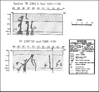
3. 5 Other structures observed in the trenches
The description of two trenches (4 m deep and 10 m long) and NW-SE direction permits to distinguish the bedding (S0), cleavages, folds, shears, fractures and quartz veins (figure 7). The sedimentary layering is the contact between different lithological rocks. It is characterized by beds of contrasting colors, grain size and structures of differents rocks (figure 5B).
faults. The darker areas reflect higher anomalies.
In the field, the cleavages are three in number: S1, S2 and S3. S1 cleavage is N40° to N50° direction with subvertical dip. This is a phyllitic cleavage. It is subparallel to sedimentary layering and is located in mostly clear and fine-grain rocks. The S2 cleavage is N50° to N65° direction. It is less pervasive than S1 and is best expressed in the dark beds. It is oblic on the S0 and S1, and is generated by the crenulation of S1. The S3 cleavage of N90° to N110° direction is rarely observed. When it is visible, it is associated with centimetric folds and de- formed quartz veinlets.
The shears are represented by the abundance of structures such as sigmoid shapes, often sinistral, quartz veins and folds (figure 5D).
Fractures, veins, veinlets, quartz veins and lenses were fre- quently observed in schists formations.
IJSER © 2013 http://www.ijser.org
International Journal of Scientific & Engineering Research Volume 4, Issue 2, February-2013 4
ISSN 2229-5518
Fig. 7. Longitudinal sections of trenches showing the appearance veins and quartz veins (modified after Ahoua Yapo [7]). Note that the tourmaline-quartz veins are often vertical.
4 DISCUSSION
The network analysis of the lineaments shows directions with different lengths. This reflects different lithologies in areas of both sides of the Hana fault. The western area, consisting of schists, is affected by NW-SE fracturation over long distances (over 10 km on average). The eastern area, made of granitic and gneissic formations, is rather affected by fractures with N55° to N75° direction. NW-SE fractures are small size.
The presence of circular structures in the two areas may re- flect the presence of granitic plutons ([8], [9]) and will have played a dynamic role in providing the mineralizing fluid with hydrothermal origin [10]. This phenomenon is similar to that observed in the mine of "Pederosa Pataz" in Peru [11], where two stages of alteration are observed. The first stage is related to the establishment and cooling of the intrusion, while the second stage is related to hydrothermal processes [11] that are dominated by sericitization and chloritization. This phe- nomenon is identical to the west of the Hana fault, where lithologies contain sericite and chlorite schists.
Chronologically, the relationships between major fractures permit us to propose the order of the earliest to the latest frac- tures:
1. N00° fractures (FBA or Bagoléoua fault).
2. N65° fractures.
3. N90° fractures.
4. N40° fractures (FSo or fault Soubré).
5. N120° fractures (FPE or Petigoa fault).
6. N130° fractures (FMaE or Maboguhé East fault).
This network fractures would have performed in flaws that
led the mineralizing fluid and ensured their distribution. This
case is the same in the mine of "Pedorosa Pataz" in Peru. [11].
The average grades of 0.4 g/t to over 10g/t were obtained
in sections of trenches with high densities of fractures, sig-
moidal veins, isoclinal folds and tension gashes. This observa-
tion is the same in the "Wulong" shear zone in China, where ductile deformation is characterized by elongated quartz grains, pressure shadows, slip lineations, folds and gauges [12].
The mineralized veins have branches that match those of S1 and S2 cleavages. The highly mineralized mylonite zones ob- served in the trenches are consistent with the interpretations proposed by Milesi [4].
From the above, we can say that the mineralization of Parc- Sou seems to be related to the fracturation of the satellites fault of Hana and D2 shearing. Structural analysis has revealed that the mineralization is located within the veins present in the shear zone. Dubé [13] made the same observations in the metallogeny gold of the sill of "Bourbeau" in Quebec. For him, near the mineralized zone, alteration is characterized by the presence of sericite, chlorite and deformed quartz veins.
We observe that the vein blocks near the main fault, some- times have special structures (folding, thinning, splitting into range along a fault) and a marked by an increase of the miner- alization. Let us examine these facts.
4.1 Particular structures
Folding of veins near the Hana fault is due undoubtedly to the tectonic compression effect in schists. These are more rigid, have corrugated so as to maintain a constant length over a reduced distance.
The thinning of the veins in the immediate vicinity of Hana fault, could be explained by the following fact: if the result of the stress was more a slip direction to the fault plane, it could with plasticity of the schists, create a thinning of the veins, which this time has increased. It could also allow a certain plasticity of the silica filling the veins at the time of defor- mation, because we can not accept a rigidity comparable to that of present quartz.
Bursts in a range of a vein breakage could be explained as above by a plastic state of silica. It has filled a single vein be- fore scaterring. The silica had to be sufficiently plastic to fill the new structure due to multiple shear stresses.
The abundance of mineralization in the vicinity of the Hana fault is due to the fracturation of the veins more intense in these areas than in the other blocks away. Thus, the structural style that involves such intense deformation has enabled the establishment of mineralization during the time of the frac- turation, which was also the time of veins formation. Lapointe [14] made the same observations in the characterization of gold bearing veins system of "Aquilon-Baie James", in north Quebec.
4.2 Origin of the mineralization
Gold mineralization would have resulted from the filling of fractures by chemical precipitation of anomalous substances from the circulation of thermal fluids. We can assume the following two assumptions: 1) the formation of veins by depo- sition of silica from a solution circulating in the anomalous fractures, 2) the formation of veins by injection into the frac- tures, silica in the fluid state charge of other minerals.
IJSER © 2013 http://www.ijser.org
International Journal of Scientific & Engineering Research Volume 4, Issue 2, February-2013 5
ISSN 2229-5518
5 CONCLUSION
The auriferous prospect of Parc-Sou is located on the sinistral Hana fault. At the west of this fault, whe have schists for- mations and in the eastern part, whe have granitic and gneiss- ic formations.
Mineralization is present mainly in schists and in the zone of Hana fault. It is linked to veins structures (fracturation and hydrothermal fluids) and results of shear movements evi- denced by sigmoidal tourmaline-quartz veins.
The host rocks of the mineralization appears as purplish marons argillites, cleavages, derived from basic formations, with beds of colored gray to black schists, probably originat- ing from alteration of tourmaline.
REFERENCES
[1] A. Papon, "Géologie et minéralisations du sud-ouest de la Côte d'Ivoire", Mem. BRGM (France), vol. 80, 284 p., 1973
[2] A.N. Kouamelan, "Géochronologie des formations archéenne et protérozoïque de la dorsale de Man en Côte d’Ivoire. Implication pour la transition archéen-protérozoique", Thèse doct.,université de rennes i (France), mém. Géoscience Rennes, no. 73, 290 p., 1996
[3] M. Bolgarsky, "Etude géologique et description pétrographique du sud-ouest de la côte d’ivoire", Direction des mines AOF, Dakar, Bull., no. 9, 17 p., 1950
[4] J.P. Milesi, J.L. Feybesse, P. Ledru, A. Dommanget, M.F Ouedraogo, E. Marcoux, A.E. Prost, C Vinchon, J. P. Sylvain, V. Johan, M. Tegyey, J.Y. Calvey and Ph. Lagny, "Les minéralisations aurifères de l’afrique de l’ouest. Leurs relations avec l’évolution lithostructurale au proté- rozoïque inférieur", Chron. Rech. Min. (France), no. 497, pp. 3-98, 1989
[5] A.K.K. Rompel, A.M. Koné, and T.M.I.A.G. Buvenich, "Structural interpretation of the hana-lobo concession area, western ivory coast", Internal AAC report, no. 15,133/500/98/78, 23 p., 1998
[6] S. Lemoine, "Evolution géologique de la région de Dabakala (NE de la Côte d'Ivoire) au protérozoïque. Possibilités d'extension au reste de la Côte d'Ivoire et au Burkina Faso: similitudes et différences; les linéaments de Greenville-Ferkessédougou et Grand Cess- Niakaramandougou", Thèse ès sciences, Université Clermont-Ferrand (France), 388 p., 1988
[7] N.A. Yapo, "Caractérisation de la shear zone aurifère de Parc-Sou, Pra 59 Hana-Lobo", Mem. Fin d'études, EFCPC/CI2TP, INP-HB Ya- moussoukro (Côte d'Ivoire), 80 p., 2006
[8] J. Rolet, H. Yesou and Y. Besnus, "Structures circulaires et réseaux de fractures en pays granitique. Analyse de données spot, landsat tm et seasat sur le massif armoricain", Bull. Soc. Géol. (France), vol. 164, no.
2, pp. 199-214, 1993
[9] G. Ouattara, "Structure du batholite de Ferkessédougou (secteur de Zuénoula, Côte d’Ivoire) : implications sur l’interprétation du paléo- protérozoïque d’afrique de l’ouest à 2.1 Ga", Thèse de doct., Université d’Orléans (France), 291 p., 1998
[10] M. Keïta, "Caractérisation des gisements d’or filoniens concordants dans les turbidites plissées de Jinping sud-est Guizhou (Chine)", Thèse de doct., Université du Qquébec à Chicoutimi (Canada), 342 p., 2007
[11] C. Ore Sanchez, "Caractérisation et rôle des failles (E-W) sécantes dans le contrôle de la minéralisation aurifère à la mine poderosa pa- taz (pérou)", Mem. de maîtrise, Université du Québec à Chicoutimi (Cana- da), 182 p., 2006
[12] D. Guo, "Caractéristiques structurales de la zone de cisaillement de
wulong et de la minéralisation relative d’or dans le camp d’or de wWulong, province du sud-est de Liaoning (Chine)", Thèse de doct., Université du Québec à Chicoutimi (Canada), 193 p., 2001
[13] B. Dube, "Métallogénie aurifère du filon-couche de Bourbeau : région de Chibougamau, Québec", Thèse de doct., Université du Québec à Chi- coutimi (Canada), 353 p., 1990
[14] I. Lapointe, "Caractérisation du système aurifère filonien d’Aquilon- baie James, Québec", Mem. de Maîtrise, Université du Québec à Chicou- timi (Canada), 212 p., 2006
IJSER © 2013 http://www.ijser.org