International Journal of Scientific & Engineering Research, Volume 4, Issue 11, November-2013 1089
ISSN 2229-5518
Geomorphological investigations of Bor River Basin (Tributary of Pedi River) Amravati District, Maharashtra using Remote Sensing and GIS techniques
Khadri, S.F.R and Nitesh G Thakur
SGB Amravati University, Amravati-444602 (MS). khadrisfr@rediffmail.com
Abstract
Detailed morphometric analysis of the Bor River basin in Amravati district has been attempted to delineate the various groundwater potential zones based on hydrogeomorphological investigations Morphometric analysis is the measurement and mathematical analysis of the configuration of the earth's surface, shape and dimension of its landforms (Clarke, 1966). This analysis can be achieved through measurement of linear, aerial and relief aspects of the basin and slope contribution (Nag and Chakraborty, 2003). The present study area of Bor River basin is a tributary of Pedi River lying in the Amravati district. For the Morphometric analysis Geographic information system techniques has been used and Strahler (1964) stream order method used for stream ordering. The drainage density (D) of study area is 1.9674 km indicating low to moderate drainage density.
In this study an attempt has been made to understand the morpho-tectonic analysis of the Bor river basin by utilizing the remote sensing and GIS techniques for delineating groundwater potential zones for the sustainable development of the region. By utilizing the remote sensing and GIS techniques, various maps have been prepared to delineate the groundwater potential zones for the sustainable development of the Bor River basin.
Key Words: Geomorphology, morphotectonic analysis, Remote sensing, GIS, groundwater potential
Introduction
Morphometric analysis requires measurement of linear features, aerial aspects and gradient of channel network of the drainage basin (Nautiyal, 1994). Morphometric analysis of a River basin provides a quantitative description of the drainage system, which is an important aspect of the characterization of watersheds (Strahler,1964). Identification of drainage networks within basins or sub basins can be achieved using traditional methods such as field observations and topographic maps or alternatively with advanced methods using remote sensing and GIS (Macka 2001; Sreedevi et al., 2009). The study of the river basin morphometry analysis provides the useful parameter for the assessment of the groundwater potential, surface and groundwater resource management, runoff and geographic characteristics of the drainage system. Morphometry is the measurement and mathematical analysis of the configuration of the earth's surface, shape, dimension of its landforms (Clarke, 1966). The morphometry analysis includes the linear aspects and aerial aspects, in the linear aspects the stream ordering, stream length,
IJSER © 2013 http://www.ijser.org
International Journal of Scientific & Engineering Research, Volume 4, Issue 11, November-2013 1090
ISSN 2229-5518
stream length ratio, and bifurcation ratio and in the aerial aspect the drainage density, stream frequency, form factor, circulatory ratio, and elongated ratio has been calculated.
Study Area:
The study area selected for the present work is a part of Bor Nadi, Amravati district, Maharashtra state. The study area falls in survey of India Toposheet no 55 G/12, 55G/16 and 55
H/13 lies between 21° 15' N to 22° 0' N and 77° 30' E to 77° 45' E. The study area occupies an area of 172 square kilometers. The Bor Nadi Basin is part of Bhatkuli tahasil, Amravati district
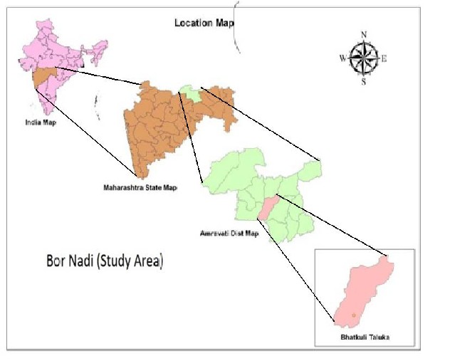
of Maharashtra state. It located of 6-7 kms from the Amravati city.
Fig 1- Location map of study Area.
Objectives:
The main objective of the present study is to analyze the morphometry of the basin using
GIS techniques in order to understand the hydrogeological aspects of the region by locating groundwater potential aquifer zones.
METHODOLOGY
IJSER © 2013 http://www.ijser.org
International Journal of Scientific & Engineering Research, Volume 4, Issue 11, November-2013 1091
ISSN 2229-5518
The major goal of this study is to develop a viable methodology for producing GIS data model for preliminary location of Bor river basin, using Arc Map 9.3, Arc GIS 9.3. The Survey of India Toposheet no. 55H/13,55G/12,55G/16 at the scale of 1:50000 used as base map for stream network. The scanned toposheet georeferenced using (Arc GIS 9.3) and stream network digitized using digitization tool and Strahler (1964) stream ordering method used for the stream ordering.
Map Composition
Once the geodatabase of morphometry data is ready, the maps have been composed on
1:50,000 scales. The map composition has been done in ARC GIS-ARC MAP environment using the style file generated for this purpose and defining the symbols for landforms and base features, has been used for representing the representing the respective features in the final Geohydrological map.
The followings Steps are involved in the integration:
1. Generation of coverage's of the base map in the ARC MAP environment.
2. Editing the coverage's to remove errors, such as dangle nodes, overshoots, undershoots, etc.
3. Building the topology after the errors are brought within the tolerance limits.
4. Labeling the features as per the standard codes / symbols for representing
hydrogeological / base map units.
5. Map composition for final output generation.
IJSER © 2013 http://www.ijser.org
International Journal of Scientific & Engineering Research, Volume 4, Issue 11, November-2013 1092
ISSN 2229-5518
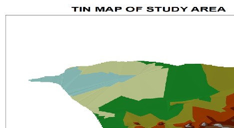
Fig 2 Triangular Irregular Network map showing the digital elevation of the Bor River basin
Morphometric analysis
Morphometric is the measurement and mathematical analysis of the configuration of the
earth's surface, shape and dimension of its landforms (Agarwal, 1998; Obi Reddy et al., 2002). A
major emphasis in geomorphology over the past several decades has been on the development of quantitative physiographic methods to describe the evolution and behavior of surface drainage networks (Horton, 1945; Leopold & Maddock, 1953; Abrahams, 1984).
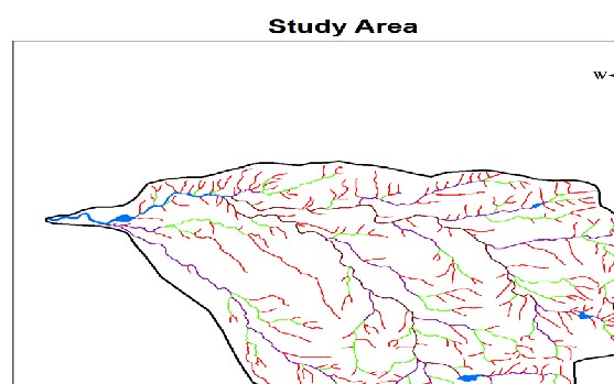
The total drainage area of Bor river basin is 172sq.km.. The drainage pattern noticed in
area is mainly dendritic with radial patten (figure 2). The details of stream characterics confirm with Horton's (1932) "law of stream numbers" which states that the number of stream of different order in given drainage basin tends closely to approximately a geometric ratio. It also confirms with Horton's (1932) the "law of stream length" which states that the average length of strain of each of the different order in a basin tends closely to approximates a direct geometric ratio
IJSER © 2013 http://www.ijser.org
International Journal of Scientific & Engineering Research, Volume 4, Issue 11, November-2013 1093
ISSN 2229-5518
Fig 3. Drainage map of the Bor river basin.
The linear aspects of the channel system are;
1 Stream Order (U),
2. Stream Length (Lu), and
3. Bifurcation Ratio (Rb )
4. Stream Number
Stream Order (U)
The first step in morphometric analysis of a drainage basin is the designation of stream order. In the present study, the channel segment of the drainage basin has been ranked according to
Strahler’s stream ordering system. According to Strahler (1964), the smallest fingertip tributaries are designated as order I. Where two first order channels join, a channel segment of order II is
formed, where two of order II joins, a segment of order III is formed so onward, The trunk stream through which all discharge of water and sediment passes is therefore the stream segment
of highest order. In the Bor river basin having up to IV th stream order (Figure 2 and Table 1).
Table 1- Stream order ,Total Stream Length and Bifuration ratio.
Stre am Orde r (U) | Num ber of Strea ms (Nu) | Total length of Strea ms in km (Lu) | Bifurc ation Ratio (Rb) | Mean Bifurca tion Ratio |
I | 295 | 185.54 | - | 4.78 |
II | 66 | 69.78 | 4.67 | 4.78 |
III | 18 | 53.39 | 3.67 | 4.78 |
IV | 3 | 29.69 | 6 | 4.78 |
Stream Length (Lu)
According to Horton, the mean length of the stream is the ratio of the length of the stream
is of the stream of each order to the stream of each order to the number of segments of the same order. In this study, it has been noticed that the length of the stream decreases with stream order
IJSER © 2013 http://www.ijser.org
International Journal of Scientific & Engineering Research, Volume 4, Issue 11, November-2013 1094
ISSN 2229-5518
indicating the characteristic size of components of drainage network and its contributing basin surface.
Bifurcation ratio (Rb):
Bifurcation ratio is related to the branching pattern of a drainage network and is defined
as the ratio between the total numbers of stream segments of one order to that of the next higher order in a drainage basin (Schumn, 1956). Also, It is relation between no. of streams of one order an of next higher order which was obtain by dividing no. of streams in one order by the no. of the stream in next highest order for all the orders of the stream. These calculations were also based on Strahler method. Bifurcation ratios are related to to the structural control on the drainage (Nautiyal, 1994; Strahler, 1964; Chow, 1964).
The bifurcation ratio can also show which parts of a drainage basin is more likely to flood. The bifurcation ratio is not same from one to another due to irregularities in the topographic feature of the drainage basin (Table 1).
Stream Number
The counts of stream channel in its order are known as stream number. The number of the stream segments decreases as the order increases, the higher amount stream order indicates
lesser permeability and infiltration.
After assigning stream orders, the segment of each order are counted to get the number of
segment of the given order (u). the stream lengths of the various segments are measured with the help of GIS software. In the Study area, the total strains segment present 382 of which first order stream having 295 segments. The Second order stream segment are 66 and third order strain segment area 18 and the fourth order stream segment are 3
Drainage Density (D)
It is the ratio of the total length of all streams and area of the drainage basin. The result
indicate high values in the plains indicating the drainage texture, low permeability and high relief whereas it is comparatively low in the hilly terrain showing steep scraps reflecting the coarser drainage texture.
Where,
D = Lu /A
D is the drainage density of study area,
Lu is the total length of stream of all order which is 338.4 Km
A is the area of study which is 172 Km2. Therefore,
D = 338.4 /172
=1.9674
The drainage density (D) of study area is 1.9674 km indicating low to moderate drainage
density. It is suggested that the low drainage density indicated the basin is highly permeable subsoil and thick to moderate vegetative cover.
Texture Ratio (T)
Texture ratio (T) is the ratio of total no. stream of any order & perimeter of the area
which it lays. It is an important factor in the drainage morphometric analysis which is depending on the underline lithology, infiltration capacity and relief aspect of the terrain.
It is expressed by the formula, T = N1 /P
Where,
T is texture ratio of study area
IJSER © 2013 http://www.ijser.org
International Journal of Scientific & Engineering Research, Volume 4, Issue 11, November-2013 1095
ISSN 2229-5518
N1 is the total number of first order streams which is 295, P is perimeter of study area which is 56 Km,
Therefore,
T = 295/56
T = 5.2678
Stream frequency (Fs)
Stream frequency or channel frequency is the total number of stream segments of all orders per unit area (Horton, 1932).The occurrence of stream segments depends on the nature
and structure of rocks, vegetation cover, nature and amount of rainfall and soil permeability
Also, It is ratio of total no. of streams of any order & the area of the basin in which its lies.
Mathematically,
Where,
Fs = Nu /A
Nu = Total number of streams of all orders which is 382, A = area of study which is 172 Km2.
Therefore,
Fs = 382/172
Fs = 2.2209
The stream frequency value of study area is 2.2209
Circularity Ratio (Rc )
Miller (1953) defined a dimensionless circularity ratio as the ratio of basin area to the area of circle having the same perimeter as the basin. He described the basin of the circularity ratios range 0.4 to 0.5 which indicates strongly elongated and highly permeable homogenous geologic materials. The circularity ratio value (0.42) of the basin corroborates the Miller’s range which indicating that the basin is elongated in shape, low discharge of runoff and highly permeability of the subsoil condition. It is influenced by the length and frequency of streams, geological Structures, land use/ land cover, climate, relief and slope of the watershed. Mathematically expressed as,
Rc = 4πA/P2
Where,
Rc = Circulatory ratio of study area,
π = 3.14.
A = area of study which is 172 Km2.
P is perimeter of study area which is 56 Km. Therefore,
Rc = 4 ∗3.14∗ 172/(56)2
Rc = 0.6888
Elongation Ratio(Re)
Schumm (1956) used an elongation ratio,define as the ratio of diameter of circle of the same
area as the basin to the maximum basin length.It is very significant index in the analysis of basin
shape which helps given an idea about the hydrological character of a drainage basin.
Matematically it is expressed by,

Re = 2√A/π/ Lu
Where
IJSER © 2013 http://www.ijser.org
International Journal of Scientific & Engineering Research, Volume 4, Issue 11, November-2013 1096
ISSN 2229-5518
Re A | = = | Elongated ratio Area of Study |
π Lu | = = | 3.14 Total stream length. |
Form Factor (Rf)
According to Horton (1932), form factor may be defined as the ratio of basin area to
square of the basin length. The value of form factor would always be less than 0.754 (for a perfectly circular basin). Smaller the value of form factor, more elongated will be the basin. The basin with high form factors have high peak flows of shorter duration, whereas elongated watershed with low form factor ranges from 0.42 indicating them to be elongated in shape and flow for longer duration,
𝐴𝑢
Rf =

2

𝑏
A form factor nearer to zero indicates a highly elongated shape and the value that is
closer to 1 indicates circular shape. The basins with high form factor value have high peak flow for short duration whereas elongated basin with low form factor will have a flatter peak flow of longer duration. Flood flows in elongated basins are easier to manage than that of the circular basins (Nautiyal, 1994). The Renuka basin, being elongated in shape, has a Rf of 0.17
Basin Area (Au)
The area of basin is 118.86 sq. km. the basin size is small; it is likely that rainwater will
reach the main channel more rapidly than in a larger basin, where the water has much further to travel. Lag time will therefore be shorter in the smaller basin. According to Gregery and Walking (1973), the 'L' is the longest length of the basin from the catchment to the point confluence.
Basin area is the direct outcome of the drainage development in a particular basin. It is
usually seen that the basin are pear shaped in early stages, but as the cycle advances, the shape tends to become more elongated (Padmaja Rao, 1978). The shape of the basin is significant since it affects the stream discharge characteristics (Strahler. 1969).
The study areas are demarcated in to second order basin. III order basin and IV order
basin. It has long been accepted that a circular area is more likely to have a shorter lag time and a higher peak flow than an elongated basin. Three dimensionless ratios viz., form factor, circularity ratio and elongation ratio, reflect the basin shapes.
Table 2 - Areal aspects of drainage basin
Morphometric parameters | Formula | |
Area (sq.km) | A | 172 Km2 |
Perimeter (km) | P | 56 |
Drainage density (km / km2) | D = Lu/A | 1.9674 km |
Stream frequency | Fs = Nu /A | 2.2209 |
Texture ratio | T =N1 /P | 5.2678 |
Basin length (km) | Lb | 20.22 |
Circulatory ratio | Rc =4 𝜋A/ P2 | 0.6888 |
Conclusions
The present study using GIS techniques for the Morphometric analysis made the task easier of the computation of morphometric and morpho-tectonic parameters and their analysis. The Morphometric parameters such as drainage density, stream frequency and bifurcation ratio
IJSER © 2013 http://www.ijser.org
International Journal of Scientific & Engineering Research, Volume 4, Issue 11, November-2013 1097
ISSN 2229-5518
are important for the integrated decision making process in flood management, soil erosion assessment and water resource management. Various potential zones were delineated in the Bor River watershed by identification of potential aquifers. The results of this study will certainly help in understanding groundwater regime of the region by locating groundwater potential zones in the region where the hydrogeological conditions are unpredictable. Based on this study, various groundwater potential zones can be identified for the sustainable development of the region.
References
1. Agarwal, C. S (1998), study of Drainage pattern through Aerial Data in Naugarh area of
Varanasi district, UP. Journal of Indian Society of remote Sensing, 26(4), pp 169-175.
2. Chow Ven T (1964) (ed) handbook of Applied hydrology. McGraw Hill Inc, New York.
3. Gregory KJ, and Walling DE (1973), drainage basin form and process a geomorphological approach. Arnold, London.
4. Horton, R. E (1932), drainage basin characteristics, Trans.Aer.Geophy.Union, 13, pp
350-361 http://www.gisdevelopement.net.
5. Horton, R. E., (1945), Erosiona! development of streams and their drainage basins;
hydrophysical approach to quantitative morphology.Geol Surv Profess, 282-A.
6. Jawaharraj, N., Kumaraswami, K., and Ponnaiyan, K (1998), Morphometric analysis of the Upper Noyil basin (Tamil Nadu). Journal of the Deccan Geographical Society, 36, pp
15-29.
7. Kumaraswamy.K and Sivagnanam., N (1998), Morphometric characteristics of the
vaippar Basin,Tami! Nadu: A qualitative approach, Indian Journal of Landscape System and Ecological Studies, 11(11), pp 94-101.
8. Macka, Z., 2001, Determination of texture of topography from large scale contour maps. Geografski Vestnik, 73(2):53–62.
9. Miller, V. C (1953), a quantitative geomorphic study of drainage basin characteristics in
Clinch Mountain Area, Virginia and Tennessee. Technical report, 3, Office of the Naval
Research. Dept. of Geology, Columbia Univ., New York.
10. Nautiyal, M. D (1994), Morphometric Analysis of a Drainage Basin using Aerial
photographs: A case study of Khairakulli Basin, District Dehradun, Uttar Pradesh.
Journal of the Indian Society of Remote Sensing, 22(4), pp 251-261.
11. Padmaja Rao G (December 1978), some Morphometric Techniques with Relation to Discharge of Musi basin, Andhra Pradesh, pp168-176, proc. Sump on Morphology and Evolution of Landforms, Department of geology, university of Delhi, New Delhi 110
007, pp 22-23
12. Schumm, S. A (1956), evolution of drainage systems and slopes in badlands at Perth
Amboy, New Jersy. National Geological Society of American Bulletin, 67, pp 597-646.
13. Smith KG (1950), standards for grading texture of erosiona! topography. Am
14. Strahler, A. N (1964), quantitative Geomorphology of drainage basins and channel
networks. Handbook of Applied Hydrology; edited by V.T Chow (Newyork; Me Graw hill) Section, pp 4-11.
IJSER © 2013 http://www.ijser.org
International Journal of Scientific & Engineering Research, Volume 4, Issue 11, November-2013
ISSN 2229-5518
1098
15 Sreedevi, P.O. Srinivasalu. S. and Kesava Raju, K (2001), Hydrogeomorphological and groundwater prospects of the Pageru River basin by using remote sensing data. Environ Geol, 40(8), pp1088-1094
I£ER 2013 http://WWW.ISer.org