International Journal of Scientific & Engineering Research Volume 4, Issue 2, February-2013 1
ISSN 2229-5518
Geometry and kinematics of structures controlling the mineralization of Angovia gold
mine (Central Ivory Coast, West Africa)
Gnammytchet Barthélemy KOFFI, Gbele OUATTARA, Alphonse Kouakou YAO
Abstract— Previous works revealed that the gold-bearing mineralization Yaoure Mounts (central Ivory Coast) would be closely related to fractures and quartz veins. Angovia area has many fractures in a very rugged terrain with few outcrops. Hence, the importance of a detailed mapping and analysis of the fracturing of the mine Angovia. To reach our objective, we first, on regional scale and using a SAR-1 radar image, identified major fractures. Then, on local scale, on the ground in the pits, we proceeded to a systematic survey of petrographic units and geological structures. The analysis of the SAR-1 image and ground survey in central and north pits of the mine permit us to highlight five families of fractures and vein structures. These directions are: sinistral N000° to N020°, sinistral N050°-N060°, dextral N080°-N100°, dextral N120°-N140° and dextral N150°-N160°. The orebodies were subsequently disrupted by various fractures. Sinistral fractures with N050° to N060°direction fractures and dextral N120° to N140° are congeners and control the hydrothermal type gold mineralization related to the D2 phase deformation.
Index Terms— Angovia Mine, D2 phase deformation, geometry and kinematics of fractures, hydrothermal Gold mineralization, Ivory
Coast, Yaouré Mounts.
1 INTRODUCTION
—————————— ——————————
n the Yaoure Mounts (figure 1), two types of gold-bearing mineralization have been identified [1], [2], [3], [4]. This is a primary mineralization that would be of hydrothermal and structural type. The secondary mineralization remains unclear. This lastest mineralization is therefore qualified to be either alluvial, colluvial or fluvial-deltaic deposits. Prospection works made by Cluff Gold (WA) Company have shown that the primary mineralization is associated with fractures of North to South direction. Exploitation works made by the same company in different pits highlighted another direction of mineralization (East-West) in addition to the first. The cur- rent problem is to know the characteristics of these directions of mineralization and also to try to show the relationships
between them.
Yaouré region extends generally in a corridor of Birimian
formations dating from the Early Proterozoic [6], [7].
We have basic volcanics and tholeiitic volcanics series asso-
ciated with acids volcano-sediments, containing numerous
intrusions of ultrabasic to basic plutonic rocks, and some in-
termediate rocks (such as granodiorites, figure 1).
The technical report produced by SRK Consulting [8] for
Cluff Gold (WA), indicates that the Angovia gold deposit was classified as an epithermal type mineralization porphyry gold, copper and molybdenum (Au-Cu-Mo).
The report also notes the presence of potassic alteration zones associated with small intrusions of calc-alkaline, acidic to intermediate including granodiorite, tonalite and adamelites as diorites, quartz monzonites and syenites.
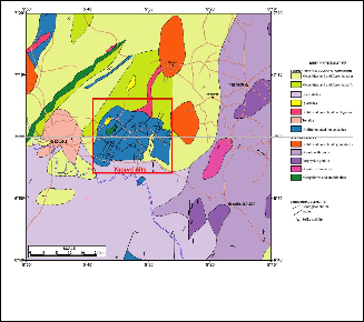
At regional scale, the mineralization appears to have been controlled by fractures and shear zones and hydrothermal alteration along fractures and folds. On a local scale, the min- eralization appears to be related to intrusions of calc-alkaline rocks and is also associated with hydrothermal alteration. This due to the presence of veinlets in stockworks composed typi- cally of tourmaline more or less silicified carbonates and pyri- tes witch appear as hydrothermal breccias.
————————————————
Gbele OUATTARA, Departement of Earth Sciences and Mineral Re- sources, Institut National Polytechnique Félix Houphouët-Boigny Yamous- soukro (Côte d'Ivoire, Ivory Coast). E-mail: gbele.ouattara@yahoo.fr
Gnammytchet Barthélemy KOFFI, Departement of Earth Sciences and
Mineral Resources, Institut National Polytechnique Félix Houphouët-
Boigny Yamoussoukro (Côte d'Ivoire, Ivory Coast).
Alphonse Kouakou YAO, Departement of Earth Sciences and Mineral
Resources, Institut National Polytechnique Félix Houphouët-Boigny Ya-
moussoukro (Côte d'Ivoire, Ivory Coast).
Fig. 1. Simplified geological map of Yaouré region (modified according Jaujou, [5]).
IJSER © 2013 http://www.ijser.org
International Journal of Scientific & Engineering Research Volume 4, Issue 2, February-2013 2
ISSN 2229-5518
2 RESULTS
2.1 Geological Map from SAR-1 image interpretation
The analysis of the SAR-1 image of figure 2a permit to identify four major families of fractures. These are:
1. submeridian fractures zones of Koudougou, Kaviessou and Kouakounyanou. They are characterized on the radar image by discrete sets of parallel lines (figure 2b). In the field, they affect the tonalitic granodiorite of Bouaflé. The deformation is marked by a cleavage and the stretching and enclaves in the N170° direction. These fractures are shifted by N160°dextral fractures.
2. NW-SE fractures zones of Toumbokro and Koblata. In the field, they crosscut quartz veins in dextral with N090° direction.
3. NE-SW fractures zones of Kossou, Angovia and Dé- gbézré are characterized by shear zones crosscutting quartz veins in the sinistral N120°direction.
4. and finally the fractures zones Y and Z of E-W direc-
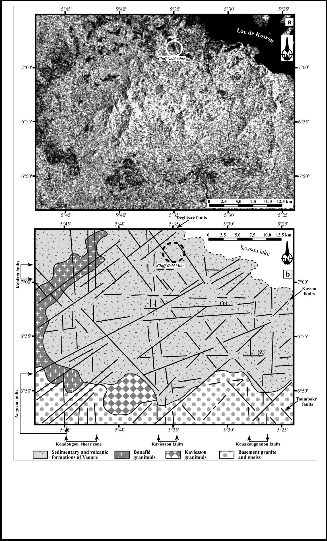
tion (figure 2b).
2.2 Detail mapping established in the pits
On the detail geological map established in the north pit (fig- ure 3), two petrographic facies were mapped, and also veins and quartz veins. The andesitic rocks have pillow lavas struc- tures. Granodiorites appear as intrusions or as veins with a NW-SE and NE-SW directions (figure 4). Veins and quartz veins follow our four main directions: NS to NNE-SSW, E-W, NW-SE and NE-SW. Their shape is reminiscent of structures into strands (veins NS direction) and tension fractures (veins trending NE-SW, E-W and NW-SE). Directions are parallel to the mineralized zones composed of quartz veins and granodi- orite.
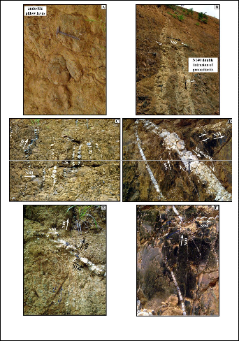
Fig. 3: Detail geological map performed in the north pit.
Fig. 2. a = Extract from SAR-1 radar image (descending orbit); b
= Geological Map of the mountains of téléanalytique Yaoure
obtained from the image of figure 2a.
Fig. 4. Photographics showing some structures in the Angovia mine.
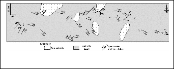
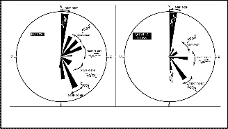
From structural data collected in the pits, we produced two diagrams (figure 5). The rose diagram of fractures show five families of fractures. The rose diagram of veins and quartz
IJSER © 2013 http://www.ijser.org
International Journal of Scientific & Engineering Research Volume 4, Issue 2, February-2013 3
ISSN 2229-5518
veins highlights four families with N000°-N020°, N050°- N060°, N080°-N100° and N120°-N140° directions.
From these different structural observations collected in the pits, we have established the following relative chronology between the fractures. From oldest to most recent, we have:
1. sinistral NS to N020°.
2. dextral N080° to N100°.
3. sinistral N050° to N060°.
4. dextral N120° to N140°.
5. dextral N150° to N160°.
Moreover, N050° to N060° directions and N120° to N140°
are conjugated.
N080° to N100°, N050° to N060°, N120° to N140° and N150° to
N160°.
The geological map drawn to by Cluff Gold (WA) at
1/60.000 scale highlights three main directions of fractures: NS
to NNE-SSW, E-W and NW-SE (figure 6). The detail geological
map of established in the north pit gives two lithologic facies:
andesitic pillow lavas intruded by granodiorite dykes, veins
and quartz veins. These dykes and quartz veins have different
preferential directions (NS to NNE-SSW, E-W, NW-SE and
NE-SW). Their general form is in the form of boudinage struc-
tures (especially those in NS direction) and tension gashes to
the structures of NW-SE and E-W (figure 7).
Veins and quartz veins show direction of movements such as fractures. Several episodes of fracturation can be observed in the Angovia region: 1) fracturation, filling by quartz (dykes and veins) with shearing that can be likened to a phase D2a.
The hydrothermal mineralization appears to be related to this first phase, 2) fracturation of the D2a structures corresponding to the D2b phase. A second phase of mineralization is not excluded during this phase.
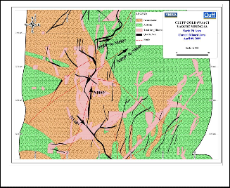
Fig. 5. Rose diagrams of fractures and veins.
3 DISCUSSION
Works of Richard Fabre [1], [2] showed a compressive D1phase, the hypothetical tectonic regime that affects the low- er Birimian (B1) and its basis. A second D2 tectonic phase marked by sinistral submeridian shear zones and the imple- mentation of large masses of granodiorite, often oriented, with hornblende and biotite, and finally late, conjugated direction dextral N130°-150° and sinistral N050°-N060° resulting from E-W compression. Gold mineralization is associated with this period.
Our work has not revealed the D1 tectonic phase. Howev- er, the D2 phase is marked by sinistral submeridian shear zones, with the presence of granodiorite veins and dykes were observed. These NS to N020° structures are the oldest in the region. The granodiorite is intrusive in andesitic lavas as veins and dykes in the N140° and N060° directions. Gold minerali- zation is associated with conjugate kinks. Dextral N130° -150° and dextral N050°-N060°, elsewhere conjugated. Their dis- placement permits the opening of NS and N080°-N100° frac- tures in tension gashes structures. The directions of mineral- ized fractures are sinistral N000°-N20°, sinistral N50°-N60°, dextral N080°-N100° and dextral N120°-N140°.
Works of Affian [3] revealed fractures zones in NS, N010° to N020°, N040° to N070°, N100° to N120°, N150° and N170° directions. However, these authors not only date these frac- tures, but do not specify their movements. Our field works were used to characterize the five families of fractures towards sinistral N000°-N20°, sinistral N50°-N60°, dextral N080°- N100°, dextral N120°-N140° and dextral N150°-N160°. We could also establish the following relative chronology between the fractures. This by going from oldest to lastest: NS to N020°,
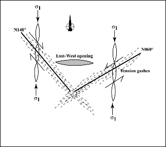
Fig. 6. Geological map of Angovia north pit area.
Fig. 7. Structural model of the auriferous mineralization in Ango- via mine.
IJSER © 2013 http://www.ijser.org
International Journal of Scientific & Engineering Research Volume 4, Issue 2, February-2013 4
ISSN 2229-5518
4 CONCLUSION
Analysis of the SAR-1 radar image permits the identification of four families of major fractures. These are: fractures zones of Koudougou, Kaviessou and Kouakounyanou with subme- ridian direction, fractures zones of Toumbokro and Koblata with NW-SE direction, fractures zones of Kossou, Angovia and Dégbézré trending NE-SO, and finally the fractures zones Y and Z of E-W direction.
The geological surveys made in the central and northern pits helped to highlight the characteristics of fractures and veins structures. Five families of fractures and vein structures were identified. They are sinistral N000° to N020°, sinistral N50° to N60°, dextral N080° to N100°, dextral N120° to N140° and dextral N150° to N160°.The relative timing of regional tectonic events from the oldest to the most recent being: NS to N020°, N080° to N100°, N050° to N060°, N120° to N140° and N150° to N160°. However, the N050° to N060° directions and N120° to N140° are conjugated. Two times of fracturation (D2a and D2b) have been, also, identified and can explain two times of mineralization.
We propose this metallotectic model: Angovia auriferous mineralization is structural and hydrothermal type. It is linked to sinistral N050°-N060° and dextral N120°- N140° conjugated fractures. The movements of these fractures make the opening and the mineralization of earlier ones (N000°-N020°, N060°, N080°-100° and N140°). Mineralized structures were later disrupted by N160° faults. Our study can help a better explo- ration of the ore in the mine, but can also guid regional explo- ration.
REFERENCES
[1] R. Fabre, P. Ledru and J.P. Milesi, "Le Protérozoïque inférieur (Birimien) du centre de la Côte-d'Ivoire: évolution tectonique et corrélations," C. R. Acad. Sci. Paris, vol. 311, ser. II, pp. 971-976, 1990
[2] R. Fabre and B. Morel, "Stratigraphie des unités birimiennes dans le centre de la Côte d'Ivoire (Afrique de l'Ouest)," Bull. Soc. géol., Fr., vol. 164, no. 4, pp. 609-621, 1993
[3] K. Affian,F.B. Anoh, E.V. Djagoua, M. Robin, M.C. Azagoh, P.
NGuessan, K.F. Kouamé, M.B. Saley and J. Biémi, "Contribution de la télédétection à la recherche de gisement d’or dans la région d’Angovia en Côte d’Ivoire," Télédétection, vol. 4, no. 3, pp. 277-288,
2004
[4] M. Diallo, "Cartographie géologique et structurale: Proposition d’un modèle géologique du corps minéralisé," Mémoire de fin d’étude pour l’obtention du diplôme d’ingénieur de technique, INP-HB, Ya- moussoukro, Côte d’Ivoire, 56 p., 2009
[5] M. Jaujou, "Le levé géologique du degré carré de Bouaké," Rapport de fin de mission, Direction des mines et de la géologie, Abidjan, Côte-d'Ivoire, 1970
[6] P. Leblond, "Contribution aux études hydrogéologiques en Côte d’Ivoire. Région de Yamoussoukro,", Rapport interne, Station expé- rimentale de l’ENSTP, Yamoussoukro, Côte dIvoire, 1984
[7] J.P. Milési, J.L. Feybesse, P. Ledru, A. Dommanget, M.F. Ouédraogo, E. Marcoux, A.E. Prost, C. Vinchon, J.P. Sylvain, V. Johan, M. Tegyey, J.Y. Calvez and Ph. Lagny, "Les minéralisations aurifères de l'Afrique de l'Ouest. Leur évolution lithostructurale au Protérozoïque infé-
rieur," Chron. Rech. min., Fr., vol. 497, pp. 3-98, 1989
[8] Srk Consulting (UK) Ltd, "Technical review of the Angovia gold mine, mount Yaouré, Côte d’Ivoire," Prepared under National In- strument 43-101 and accompagning documents 43-101F1 and 43-
101CP, Technical Report Prepared for CLUFF GOLD PLC, 24 Queen Anne Gate, London (UK), SW1H 9AA, 2008, 46 p., available at http://www.srk.co.uk / www.cluffgold.com, january 2011
IJSER © 2013 http://www.ijser.org