The research paper published by IJSER journal is about Environmental Impact Assessment (EIA) of Nile River Bed Level Variation at El Menia Reach (Case Study) 1
ISSN 2229-5518
Environmental Impact Assessment (EIA) of Nile
River Bed Level Variation at El Menia Reach
(Case Study)
R. Elgohary,
Central Laboratory for Environmental Quality Monitoring, National Water Research Center, Egypt
E-mail:rm.elgohary@yahoo.com
—————————— ——————————
The main aim of the study was to detect The environmental impact of Nile river bed level variation on water quality,
aquatic life and river navigation. The study was achieved to reach the best solution for the negative impact of this pheno- menon in order to overcome its side effect.
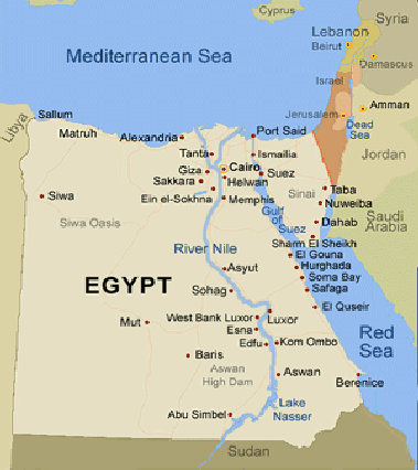
The study was held from Km 679.65 to Km 680.65 at El Menia reach of the Nile river and the distance was measured from Aswan dam as shown in fig (1).
Many data were collected in study region such as bed level, river bed coordinates, water depth, water discharge, bed par- ticle size and sediment discharge.
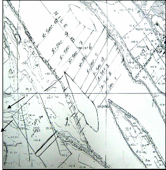
The study region was divided into 10 different sections in or- der to find the bed level variation of each section under the effect of the different variables along different years as shown in fig (2). The data of bed level variation along the years was taken from previous study [1].
IJSER © 2012
The research paper published by IJSER journal is about Environmental Impact Assessment (EIA) of Nile River Bed Level Variation at El Menia Reach (Case Study) 2
ISSN 2229-5518
‘‘Fig 1. Egypt Nile river”
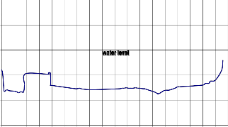
beni ahmed water station at el -minia cross section No.(1)
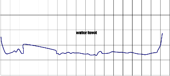
50
45
40
35
The water sections profiles (1), (5) and (10) at year 2001 are
shown from fig (3) to fig(5) as a sample of water sections pro-
files data as mentioned in [1].![]()
![]()
‘‘Fig 3. The water section (1) profile at year 2001”
‘‘Fig 4. The water section (5) profile at year 2001”![]()
‘‘Fig 5. The water section (10) profile at year 2001”
It was clear from the previous data which mentioned before in[1] that the bed level is increasing along the years in some part of the river reacbehni ahamend wdaterisstatiodn aet ecl -mrieniaasing in other different parts which will lead to bocrotshs secptionoNso.i(1t0i) ve and negative impact.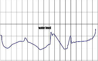
50
45
40
35
30
30
25
0.0 50.0 100.0 150.0 200.0 250.0 300.0 350.0 400.0 450.0 500.0 550.0 600.0 650.0 700.0 750.0 800.0 850.0 900.0
beni ahmed water sdtaistitoa ncaet(mel) -minia cross section No.(5)
50
45
40
35
30
25
0.0 50.0 100.0 150.0 200.0 250.0 300.0 350.0 400.0 450.0 500.0 550.0 600.0 650.0 700.0 750.0 800.0 850.0 900.0 distance (m)
‘‘Fig 2. The plan of the different sctions at El Menia
reach”
25
0.0 50.0 100.0 150.0 200.0 250.0 300.0 350.0 400.0 450.0 500.0 550.0 600.0 650.0 700.0 750.0 800.0 850.0 900.0 distance (m)
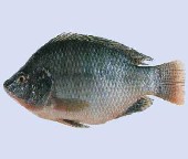
Nile river contains a lot of aquatic lives such as Eichhornia crassipes (water Hyacinth). This plant rise 1 m above water surface level and has long sponge stem, free rootas and 8-10 purple flowers as shown in fig(6). This kind of plant will grow up easily in shallow water depth which will obstruct ships navigational course. Nile river contains also many kinds of fish species such as Nile Tilapia which feeds on the bottom river grass as shown in fig(7). The shallowness of water will increase the water temperature which will provide a suitable atmosphere for fish egg incubation. Also shallowness of water permit sunlight to penetrate all the way to the bottom, allow- ing photosynthesis to occur throughout the water column and on the bottom allow grass to grow faster which will be availa- ble for fish to feed on it.
IJSER © 2012
The research paper published by IJSER journal is about Environmental Impact Assessment (EIA) of Nile River Bed Level Variation at El Menia Reach (Case Study) 3
ISSN 2229-5518

Continued discharge of heavy loads of organic wastes and the increasing of stream shallowness has resulted in steady in- crease of BOD. For healthy fresh water streams, the BOD should be less than the maximum permissible level MPL of 4 mg/l. If the shallowness of water increased the BOD in most will reach the MPL for fresh water bodies such as fish and al- gae.
‘‘Fig 6. Water Hyacinth” ‘‘Fig 7. Nile Tilapia”
Food webs in shallow water [2] can be complex. Small fish may feed on terrestrial insects, benthic (bottom dwelling) invertebrates, and benthic and mudflat algae. These small fish, in turn, serve as food for both larger fish (contributing to the aquatic food web) and shore or marsh birds (contributing to the upland food web). In addition, nutrients from groundwa- ter, overlying estuarine water and exported marsh detritus are processed by benthic microbes and invertebrates as shown in fig(8).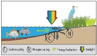
‘‘Fig 7. Food webs in shallow water”
The main channel of the river between Aswan and Cairo has been ranked in the past as class A (high quality water suitable for drinking and lesser uses subject to conventional treat- ment). The classification was based on the presence of dis- solved oxygen DO close to saturation level in most reaches of the river (8-10 mg/I), low organic load as measured by BOD (2-4 mg/I), low concentration of TDS (175 mg/I in Aswan in- creasing gradually to about 210 mg/I in Cairo). The following table(1) shows water quality of El Menia reach from year 2002 to year 2007 [3].
‘‘Table 1. Water quality of El Menia reach ”
The BOD has increased from an average value recorded at year 2002 Of 2 mg/l which increased to 2.9 mg/I at year 2007.
The TDS had an average value of 210 mg/I during the year
2002 which increased to 210 mg/I in year 2007 as a result of
water shallowness in addition to changes in water characteris-
tics induced by the HAD.
The first class waterway navigation in Egypt is the pusher barge, pushed dump barge and tourist-floating hotels are the majority. The obtained classification of the total navigation vessels in Egypt is given in Table (2).
‘‘Table 2. Navigation Units in Egypt”
No | Division | Total Number |
1 | River Transport Company | 240 |
2 | Water Transport Compa- ny | 216 |
3 | Sugar Refining Factory | 191 |
4 | Private Sector | 4418 |
5 | Public Sector | 256 |
6 | Governmental Units | 325 |
Total Number | 5646 |
The overall transported cargo is reduced from 3% of total transported goods in Egypt in 1990 to only 1% in 2001 due to:
1-The shallowness of water cause that the river depth in some areas less than the minimum required of ships draft.
2-Lack of marking system and positioning or navigation maps along both sides of the River.
-Get the benefit of the increasing of Nile river fish number due to the shallowness of water depth as a natural source of foods of urban areas on banks sides.
-Dredging the shallowness spots in some places of The Nile river course which affect on navigation course.
-Recommended the east bank of the Nile river at El Menia reach as a suitable place for water station intake because in this side erosion processes is greater than sedimentation and that will prevent the intake pipes from clogging by sediments.
-Eliminate water Hyacinth from Nile river which obstruct ships navigation by using friendly environmental system to git rid of it without any biological effect.
IJSER © 2012
The research paper published by IJSER journal is about Environmental Impact Assessment (EIA) of Nile River Bed Level Variation at El Menia Reach (Case Study) 4
ISSN 2229-5518
-Providing the total length of waterway channel, from Aswan to Cairo, by the necessary traffic control aids required for safe navigation.
-Producing navigation charts to cover the total length of the
River Nile from Aswan to Cairo.
I dedicate this paper to all my Egyptian citizens.
[1] Elgohary, T. (2010). “Prediction of Bed Level Variation of Nile
River Due to the Effect of Sedimentation Processes at El Menia
Reach” IJAS, volume4, number(2), ISSN: 1944-6394 (2011).
[2]News letter of the center for coastal resources management, Winter 2010, Vol. 5, No. 1
[3]Advisory Panel Project on Water Management Report on:The River Nile Management, in Egypt (April 2008, Den Bosch, The Netherlands), January, 2008.
[4]Brooks, N.H. (1955). “Mechanics of streams with Movable Beds of Fine Sand,” Proceedings of the ASCE,vol,81,no. 668,Pp.668-1-668-
28.
[5-Chang, F.M., D.B. Simons, and E.V. Richardson (1960) “Total Bed Material Discharge in Alluvial Channels ![]() U.SGeological Survey Water-Supply Paper 1498-I.
U.SGeological Survey Water-Supply Paper 1498-I.
![]()
[6]Corey, W.C Formation of flood plain lands” ASCE hydraulic division ,May(1954)
[7]Einstein, H. A. (1942).“Formula for the Transportation of
![]()
![]()
![]()
[8]Enistein, H. A. (1950) The Bed-Load Function for Sediment Transportation in Open Channel Flows U.S. Department of Agriculture,Soil Conservation Service, Technical Bulletin no. 1026.
IJSER © 2012