International Journal of Scientific & Engineering Research, Volume 6, Issue 3, March-2015 246
ISSN 2229-5518
Disaster due to slope failure in the Pahartoli
Area of the Chittagong city, Bangladesh
Md Shofiqul Islam1*, Mosarraf Hosain1, Mohammad Shahidul Islam1, A.S. Daiyan Ahmed1, Farjana Hoque1, Shefa Ul
Karim1, Md Aminul Islam2
Abstract— Slope failure disasters due to heavy monsoon rainfall are happening as the consequences of excessive hill cutting for urbanization and deforestation in the Chittagong city, causing fatal accident including the loss of lives and properties. In this paper, we present the main causes of landslides by determining the engineering and geological properties of the in-situ soil samples. The analyzed slopes are consisting of two types of formations where the lower part comprises of hard and compact silt/clay layer with high cohesion (2.08-2.17 KPa) and Young modulus (117-234 KPa) and the upper part consists of loose sand with relatively low cohesion (1.25-1.83 KPa) and Young modulus (12.51-25.02 KPa). At dry condition the sand layer has a higher friction angle of 45° whereas on the contrary, it has 25.9° at the wet condition. The mathematical modeling using both liquid equilibrium and finite element method shows that the analyzed slopes are relatively stable (Factor of Safety and Shear Reduction Factor is more than 1) at dry condition. However, at wet condition most of the slopes are vulnerable for landslide and need supports be stable for saving the people from accident and injury.
Index Terms—Landslide, Slope stability, Soil sample, Rainfall, Chittagong, Hill, Akbar Shah, Andhar Manik
—————————— ——————————
1 INTRODUCTION
lope failure of hills in Chittagong city is a common inci- dent over the last few years. It is a devastating occurrence that is being caused by some natural agents as well as
man-made interferences and thus claiming many lives and properties. At least 185 people died in the last seven years due to slope failure, in which, 127 in 2007 alone. The disaster took place in Lalkhan Bazar, Motijharna, Tankir Pahar, Batali Hill, Lebu Bagan and Pahartali areas (Akber Shah Area and Andhar Manik Hill).
The natural causes of slope failure are heavy rainfall, earth- quake, volcanic eruption, snow melting and others. However, in the case of slope failure of hills in Chittagong city, the main cause is hill cutting creating steep slopes. Almost every land- slide was triggered by vulnerable steep hill slope and the gravity accelerated the landslides during the season of mon- soon. The main factors affecting the slope stability of the hills of Chittagong city are the soil type and strength, stratification, discontinuities, seepage of water through the slopes, ground water level and geometry of slopes. Some other factors that contribute to slope failure are high shear stress, lack of lateral support or removal of support, weathering and low inter- granular force due to seepage pressure.
According to the district administration, there are at least 1000 families living in and around the twelve hills in Chittagong city, which are at great risk during the monsoon. In Akber Shah area, landless peoples are living under the hills under the tin roofed hut. Unplanned urbanization is going on in this area, where the hills are being cut down and the soil is used to fill up the low lands. In both areas (Akbar Shah area and

1Department of Petroleum and Mining Engineering, Shahjalal university of Science and Technology, Sylhet 3114, Bangladesh
2Department of Petroleum Geoscience, Faculty of Science Universiti Brunei
Darussalam Jalan Tungku Link Gadong BE1410, Negara Brunei Darussalam
*Corresponding author: sho_fiq@yahoo.com
Andhar Manik Hill), the hills are cut at steep angles, which ranges from 70-85 degree. So, these areas are extremely poten- tial for slope failure and landslides.
Now-a-days, there are many techniques which are being used to investigate the failure plane in the hazardous zones. Among the techniques, the laboratory analytical method using in-situ samples along with mathematical analysis is mostly accepted to determine susceptibility of the landslide or slope failure. Moreover, some numerical modeling softwares (e.g., Slide, Phase, FLAC, Carsole, ABAQUS etc.) lead the analysis more precise with higher accuracy. Some works have been carried out in the Chittagong area with different aspects and different methods. Khan et al. [1] conducted a statistical analysis based on rainfall data. Moreover, few other works [2-3] have con- ducted on Remote sensing and GIS. However, combination of laboratory analysis of engineering properties with numerical modeling using the measured parameters is still absent. More recently, these authors conducted some works in a Lalkhan Bazar area (Islam et al. 2014a) which show realistic results with great significance. However, there is no work had con- ducted in the Pahartoli area. In this study, we aimed to 1) de- termine engineering properties (unit weight of soil, Poison’s Ratio, Young’s Modulus, Cohesion) of the soil samples, 2) de- termine the slope stability (safety factor) at dry condition and wet condition, and 3) propose the remedial measures to pro- tect the slope from failure.
2 STUDY AREA AND GEOLOGIC SETTING
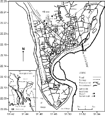
The Chittagong City (Fig. 1) of Bangladesh lies between
21°54ʹN to 22°59ʹ N latitude and 91°7ʹ E to 92°14ʹ E long i-
tude. Chittagong is the second largest city of Bangladesh with
about 168sq km area including 4 million populations. The area
of Chittagong is situated within the Tertiary hill region of
IJSER © 2015 http://www.ijser.org
International Journal of Scientific & Engineering Research, Volume 6, Issue 3, March-2015 247
ISSN 2229-5518
Folded Flank of Bengal Foredeep. The folded part is composed of the Tipam Sandstone formation and Girujan Clay formation of Pliocene age at the bottom and Dupi Tila formation of Plio- Pleistocene age at the top [4,5]. Tipam Sandstone formation is hard and compact while other sandstones are mostly moder- ate to loosely compacted and consisted of medium to fine
Fig. 1: Location map of the study area (modified after [1,5]
grained with minor amount of silt and clay [5]. The Girujan clay formation consists of mottled clay with intercalations of sand bands and occasional coal streaks. The Dupi Tila (Reimann 19933) formation is comprised of sandstone and shale [4]. The city comprises of the area of small hills and nar- row valleys, bounded by the Karnaphuli River to the south, the coastal plain and the Bay of Bengal to the west and the floodplain of the Halda River to the east. The highest level of the hills within the city area is about 60 m above mean sea level (Islam et al 2014b). The hills of the study area were cut with slopes of 70°–90° despite the potential threat of landslides because of the newer settlements of slums for the homeless people.
Pahartoli area has some vulnerable slopes (Fig. 2a-b) that may cause disaster at any time. The slope angles are ranging from
60 to 70° with some prominent slope failure features that are found in Akbar Shah (N22°21.737ʹ and E 91°47.509ʹ Fig. 2a -b) and Andar Manik (N22°22.66ʹ2 and E 91°47.724ʹ Fig. 2c -f). The lower part of the slope is comprised of hard clay for- mation while the upper part consists of mainly loose sand par- ticles (Fig. 2a-b). There are a large number of poor families living at the base of the slope in the Akbar Shah area with po- tential danger. Some seepage is observed on the foot hill in the study area which caused instability of the zone. The upper sand zone is loose at dry condition and very loose at wet con-
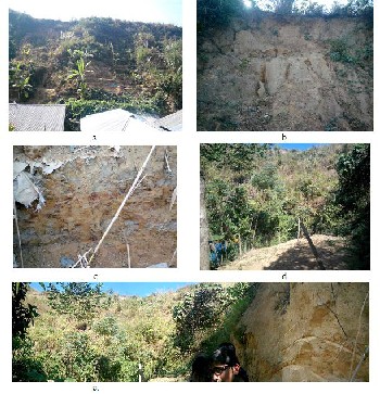
dition. This phenomenon is observed during field visit and sample collection. The Andhar Manik area (Fig. 2d-e) is very high with more than 70° slope angle. There are a few families living at the base of the slope in the Andhar Manik area with risk.
Fig. 2 Photographs of the study area, a-c) Akbar Shah, d-e) Andhar Manik
3. METHODOLOGY
Total sixteen (16) samples were collected from four (04) points in two (02) different locations (Akbar Shah area and Andhar Manik) in the Pahartoli area of the Chittagong City (Fig.1). At each point, three (03) samples were taken for the direct shear test and one (01) sample was taken for Unconfined Compres- sive Strength (UCS) test. The in situ samples are taken by cy- lindrical core sampler (made of steel) of 2 inch diameter after removing the soil/rock of weather zone. The different proper- ties of soils such as unit weight of soil, internal angle of fric- tion, cohesive strength, Poisson’s ratio, and Young’s modulus were measured by ASTM standards. These tests are conducted at the laboratory of Shahjalal University of Science & Technol- ogy. The detail method is already described in Islam et al. [6] and Islam and Hoque [7]. However, we also describe here for better understanding to the reader.
3.1 Measurement of unit weight of rock
Weight (W) of the each sample was measured by electronic weight machine using ASTM standard. Unit weight ( ) of the samples was measured using the equation

Where, V is the volume of the cylindrical sampler. The unit weight values were used to determine factor of safety using SLIDE2®.
IJSER © 2015 http://www.ijser.org
International Journal of Scientific & Engineering Research, Volume 6, Issue 3, March-2015 248
ISSN 2229-5518
3.2 Direct Shear Measurement
The test is carried out on remolded samples as well as in-situ samples in the laboratory of the department of Petroleum and Mining Engineering of Shahjalal University of Science and Technology using motorized direct shear apparatus (EDJ-2
Motorized Shear Appartus). The soil samples were compacted at optimum moisture content in a compaction mold and the assembled in the shear box. Then specimen for the direct shear test was obtained using the correct cutter provided. A normal load was applied to the specimen sample and the specimen was shared across the pre-determined horizontal plane be- tween the two halves of the shear box. This procedure was repeated for four times, including one in-situ sample and three remolded samples. Measurements of shear load, shear dis- placement and normal displacement were recorded. From the results, internal angle of friction and cohesive strength were measured using Coulomb’s shear strength equation (2).

Where τf= shearing resistance of soil at failure, the c = appar-
ent cohesion of soil, σf = total normal stress on failure plane, 
= angle of shearing resistance of soil (angle of internal fric-
tion). The values of these parameters (cohesion and angle of
internal friction) and unit weight were used to determine fac-
tor of safety using SLIDE2®.
3.3 Unconfined Compressive Strength test
According to the ASTM standard, the unconfined compressive strength is the compressive stress at which an unconfined cy- lindrical specimen of soil will fail in a simple compression test. The test was performed at the Soil Mechanics Laboratory of Civil and Environmental Engineering Department of Shahjalal University of Science and Technology is using unconfined compressive strength tester (ELE International, Model 25-
3605). Measurements of strains (%) and stresses were record- ed. From the results, Poisson’s ratio and Young’s modulus were determined. These parameters along unit weight, cohe- sion and angle of internal friction of samples were used to de- termine shear stress reduction factor using PHASE2.
3.4 Limit Equilibrium Method
The conventional limit equilibrium methods for investigating the equilibrium of soil mass tending to slide down under the influence of gravity. Transitional or rotational movement is considered on assumed or known potential slip surface below soil or rock mass. In rock slope engineering methods may be highly significant to simple block failure along distinct discon- tinuities. All methods are based on comparison of forces (mo- ments or stresses) resisting instability of the mass and those that causing instability (disturbing forces).
Advantages Limit equilibrium methods are still currently mostly used for slope stability studies. These methods consist in cut- ting the slope into fine slices so that their base can be compared with a straight line, then to write the equilibrium equations (the equilibrium of the forces and/or moments). According to the assumptions made in the efforts between the slices and the equilibrium equations considered, many alterna- tives were proposed. In the most cases, differences between the values of the safety factor obtained with the various meth-
ods are generally lower than 6% [8-10]. However, the disad- vantages of limit equilibrium are that the factors of safety are assumed to be constant along the potential slope surface and load deformation characteristics are not explicitly accounted. The Ordinary methods of slices are applicable to non- homogeneous slopes where slip surface can be approximated by a circle and based on the defining equation. The Bishop’s modified method is also applicable to non-homogeneous slopes and cohesive soils where slip surface can be approxi- mated by a circle. It is more accurate than the Ordinary Meth- od of slices, especially for analyses with high pore water pres- sures. Moreover, the jumbo generalized procedure is applica- ble to non-circular slip surface. This method is also used for shallow Long planner failure surfaces that are not parallel to ground surface. Fig. 3 shows the generalized force equilibrium of the multislice methods.
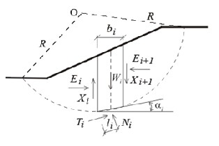
Fig. 2 The most common limit equilibrium techniques are methods of slic- es where soil mass is discretized into vertical slices.
3.4.1 Bishop’s simplified method
Bishop’s simplified method [11] is a primary slope stability method where the interslice shear forces are neglected and regardless of whether the slip surface is circular or composite that is based on the equation (3)
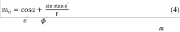
Where, ∆x is the width of the slice, and is defined by the following equation (4),
Where, and is the shear strength parameters for the center of the base of the slice, W is the weight of the slice, is the inclination of the bottom of the slice, u is the pore water pres- sure at the center of the base of the slice.
3.4.2 Janbu’s Simplified Method:
The Janbu’s simplified method [12] is similar to the Bishop’s simplified method except that the janbu’s simplified method satisfies only overall horizontal force equilibrium but not overall moment equilibrium.
The Janbu’s simplified factor of safety is actually too low, even though the slices are in force equilibrium. Since force equilib-
IJSER © 2015 http://www.ijser.org
International Journal of Scientific & Engineering Research, Volume 6, Issue 3, March-2015 249
ISSN 2229-5518
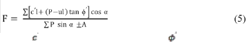
rium is sensitive to the assumed interslice shear, as in the Jun- bu’s simplified method, makes the resulting factor of safety too low for circular slip surfaces.
Where, is effective cohesion intercept, is effective angle of internal friction, l is the length of the failure surface at the base of the each slice, P is the total normal force on the base of the slice, A is the resultant external water forces, α is the angle between the tangent to the center of the base of each slice and the horizontal.
3.5 Finite Element Method- Shear reduction factor
Finite Element (FE) approach to slope stability analysis over traditional limit equilibrium methods where no assumption needs to be made in advance about the shape or location of the failure surface. Failure occurs naturally through the zones within the soil mass in which the soil shear strength is unable to sustain the applied shear stresses. The FE method preserves global equilibrium until failure is reached. If realistic soil compressibility data are available, the FE solutions will give information about deformations at working stress levels. The FE method is able to monitor progressive failure up to and including overall shear failure.
3.5.1 Shear strength reduction method:
The shear strength reduction technique for slope stability analysis includes the systematic use of finite element analysis to determine a stress reduction factor or the factor of safety, which brings a slope to verge (end) of the failure. Moreover the shear strengths of all the materials in a FE model of a slope are reduced by the SRF. The conventional method, finite ele- ment analysis of this analysis of this model is performed until a critical SRF value which induces instability is attained. With- in a specified tolerance a slope is considered unstable in SSR technique when it FE model does not converge to a solution. Shear strength reduction technique is widely used as it is readily available in many existing finite element softwares (e.g., Phase, Carsole, ABAQUS). It can be expressed in terms of principal stresses or normal stresses. Its linearity allows re- duced parameters to be calculated readily while an original shear strength model is reduced by a factor F. Reduction of the shear strength envelope by a factor F, determination of new strength model parameters that conform to the lowered enve- lope, and use of the new parameters in conventional FE Elas- to-plastic analysis.
3.2 Model Setup
On the basis of soil properties determined from the laboratory analysis, we set up mathematical modeling shown in Fig. 4. The cross-section is assumed homogeneous and isotropic Elas- to-plastic material.
4. Result and discussion
Laboratory measurement shows that the soil samples having unit weight ranging from 8.21 to 11.956 KN/m3 (Table 1)
where friction angle, cohesion and Young’s modulus of the
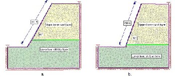
Fig. 4 Model set up for mathematical modeling of a) Akbar Shah, b) AndharManik Area
TABLE 1 ENGINEERING PROPERTIES OF THE SOIL SAMPLE IN THE
CHITTAgong City
Soil con- dition | Sample location | Unit weight (KN/m3) | Slope angle ( °) °) | Heig ht (ft) | Fric- tion angle (φ, °) | Cohe- sion (KPa) | Pois- son's ratio | Youn g's Mod- ulus (KPa) |
Wet con- dition | Akbar Shah upper layer | 11.172 | 60 | 300 | 25.94 0 | 1.080 | 0.39 | 12.51 |
Wet con- dition | Akbar Shah lower layer | 9.213 | 60 | 300 | 44.82 | 2.08 | 0.44 | 117 |
Wet con- dition | Andhar Manik upper layer | 11.956 | 70 | 250 | 26 | 1.25 | 0.48 | 115 |
Wet con- dition | Andhar- Manik lower layer | 9.213 | 70 | 250 | 44.82 | 2.08 | 0.44 | 117 |
Dry con- dition | Akbar Shah upper layer | 9.175 | 60 | 300 | 47 | 1.83 | 0.36 | 25.02 |
Dry con- dition | Akbar Shah lower layer | 8.212 | 60 | 300 | 43.48 | 2.17 | 0.41 | 234 |
Dry con- dition | Andhar- Manik upper layer | 10.154 | 70 | 250 | 45 | 1.83 | 0.45 | 230 |
Dry con- dition | Andhar- Manik lower layer | 8.212 | 70 | 250 | 43.48 | 2.17 | 0.42 | 234 |
samples decrease significantly in wet than dry condition (Ta- ble 1) which is consistent with previous result [6,10,13]. The main cause of this phenomena is the rainfall infiltration in slope that could result in varying soil suction and positive pore pressure, as well as raising soil unit weight, reducing anti-shear strength of rock and soil [13-14]. Some scientific and technical studies also (e.g., [15-19] suggest that rainfall is one of the most important triggering factor that causes landslides. The mathematical modeling result shows the effect of such condition that is induced in the landslide at wet condition in the Chittagong City (Fig. 5-6). Most of the slopes are stable at dry condition with factor of safety and Shear reduction factor values ~1 (Table 2) where slopes are vulnerable at wet condi- tion with factor of safety (FS) and shear reduction factor <1 (Table 2).
We present the rigorous analyses by using the Limit Equilibri- um Method and Finite Element Method (FEM) for strength reduction factors of different slopes at better assurance (Table
2). The SRF values are in good agreement with FS values in
IJSER © 2015 http://www.ijser.org
International Journal of Scientific & Engineering Research, Volume 6, Issue 3, March-2015 250
ISSN 2229-5518
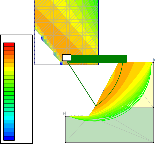
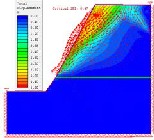
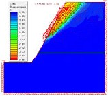
most cases. Figures (5c-d, 6c-d) show that the deformation
reasons for slope failure problems in the Chittagong city. The high hills in the city are almost bare and some covered with little herb and grass. Large tree with long root is almost de- pleted from the hills. Day-by-day the landslide susceptibility
Safety Factor
0.00
0.50
1.00
1.50
2.00
2.50
3.00
3.50
4.00
4.50
5.00
5.50
6.00+
1.10
Safety Factor
0.00
0.50
1.00
1.50
2.00
2.50
3.00
3.50
4.00
4.50
5.00
5.50
6.00+
0.49
is increasing in the Chittagong city. To protect the hurt dwell- er in the foot hill, some remedial measures such as i) landslide vulnerability assessment and zoning, ii) re-location of the foothill slums, iii) proper compliance of existing legal provi- sions, iv) real time monitoring and early warning, v) en- hancement of public awareness, vi) establishment of the emergency response and recovery team and facilities, vii) ad-
a. b.
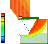
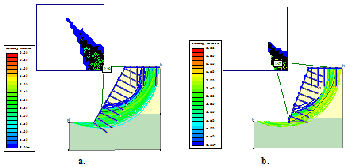
c. d.
Fig. 5 FS value using the Bishop’s simplified method at a) dry condition and b) wet condition and SRF at c) dry condition and d) wet condition of Akbar Shah area of the Chittagong city
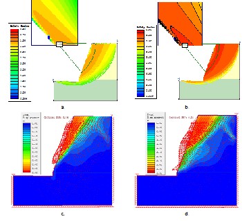
Fig. 6 FS value using the Bishop’s simplified method at a) dry condition and b) wet condition and SRF at c) dry condition and d) wet condition of the AndharManik area of the Chittagong city
vector in the slopes is indicative to greater deformation of the upper part of the slope face.
The main problems of these slopes are sharp angle and less shear strength of the material (Islam et al. 2014a,b). Islam et al. (2014a,b) also suggested that the slope would be stable at wet condition if slope angle is less or equal to the friction angle of the soil. Field observation during sample collection seemed that unwise and unregulated hill cutting by influential greedy and poor, homeless people and deforestation are the main
dressing poverty issue, and viii) strict compliance of zoning
and other legal and policy instruments etc., are proposed by
Islam et al.(2014a).
Fig. 7 FS value at wet condition with the support of geotextile and bolts for a) Akbar Shah and b) Andhar Manik of the Chittagong city
Table 2 The factor of safety and SRF values from mathemati- cal analysis of different slopes of the Pahartoli area of the Chit- tagong City
From the engineering point of view, the slope can also be made stable with the proper support system. The geotextile support (fully (100%) cover with tensile strength 40 KN/m) is proposed with bolting (length of 5 m)for the slope of Akbar Shah and AndharManik area (Fig. 7a-b) which could also be applied to other slope. Along with previously mentioned rem- edies, the support system will ensure the safe living of the poor foot hill dweller rather than the re-location issue.
5. Conclusion
Steep slopes in the Chittagong city during heavy monsoon rainfall caused the slope failure that cost the life of a large number of people. This phenomenon is due to unplanned hill cutting, deforestation and some other natural processes. The soil condition of the study area is loose and sensitive to water contact. Laboratory measurement shows that the value of fric- tion angle, cohesion and Young’s modulus is higher at dry
IJSER © 2015 http://www.ijser.org
International Journal of Scientific & Engineering Research, Volume 6, Issue 3, March-2015 251
ISSN 2229-5518
condition which reduces significantly at wet condition that leads slope failure. Major causes for the heavy rainfall infiltra- tion on the slope are increasing saturation and building posi- tive pore pressure, as well as raising soil unit weight, reducing anti-shear strength of soil. However, geotextile with bolt sup- ports are anticipated to keep the slope stable, avoiding acci- dents and even re-locate the poor hut dweller from the foothill of the city.
REFERENCES
[1] Khan YA, Lateh H, Baten MA et al. (2012) Critical antecedent rainfall condi- tions for shallow landslides in Chittagong City of Bangladesh; Env. Earth Sci.
2012; 67(1):97-106. DOI: 10.1007/s12665-011-1483-0.
[2] Khan YA and Chang C (2008) Landslide hazard mapping of Chittagong City
Area, Bangladesh. Indian Soc Eng Geol. 35(1–4): 303–311.
[3] Ahmed B (2014) Landslide susceptibility mapping using multi-criteria evalua- tion techniques in Chittagong Metropolitan Area, Bangladesh, Landslides, DOI 10.1007/s10346-014-0521-x.
[4] Evans P (1932) Tertiary succession in Assam. Trans. Min. Geol. Inst. India,
27:161-253.
[5] Reimann K-U (1993) Geology of Bangladesh; GebruderBorntraeger, Berlin,.
[6] Islam, MS, Hussain MA, Khan, YA Chowdhury, MAI, Haque MB (2014) Slope Stability Problem in the Chittagong City, Bangladesh, Journal of Ge- otechnical Engineering, 1(30): 13-25.
[7] Islam MS, Hoque, F ( 2014) River Bank Erosion of the Surma River Due to
Slope Failure. International J. Res. Innov Earth Sci., 1(2), 54-58: 13-25.
[8] Duncan, JM (1996) State of the Art: Limit Equilibrium and Finite-Element
Analysis of Slopes. J Geotech Engg, 122( 7):577-596. doi:10.1061/(ASCE)0733-
9410(1996)122:7(577)
[9] Baba K, Bahi, L, Ouadif L, Akhssas A (2012) Slope Stability Evaluations by Limit Equilibrium and Finite Element Methods Applied to a Railway in the Moroccan Rif, Open J Civil Engg, 2(1), DOI:10.4236/ojce.2012.21005
[10] Islam MS, Islam MS, Hoque F, Hosain. M, Ahmed ASD, Karim SU (2014) Landslides problem in Lalkhan Bazar Area of the Chittagong city, Bangla- desh, International J Scientific Engg Res 5(12): 918-927
[11] Bishop AW (1955) The Use of the Slip Circle in the Stability Analysis of Slopes; Géotechnique 5: 7–17p, doi: 10.1680/geot.1955.5.1.7.
[12] Janbu N, Bjerrum L, Kjaernsli B. Soil Mechanics Applied to Some Engineering
Problems (in Norwegian with English summary). Norwegian Geotech. Inst., Publication 1956:16p.
[13] Collin BD and Sitar N (2009) Geotechnical properties of cemented sands in steep slopes; J. Geotech. Geoenviron. Engg. 135: 1359-1366.
[14] Wilson RC and Dietrich WE (1987) The contribution of bedrock groundwater flows to storm runoff and high pore pressure development in hollows, Ero- sion and Sedimentation in the Pacific Rim; IAHS Publ. 165:49-59.
[15] Iverson RM (2000) Landslide triggering by rain infiltration; Water Resources
Res. 36(7):1897-1910.
[16] Hengxing L, Chenghu Z, Lee CF, et al. (2003) Rainfall-induced landslide stability analysis in response to transient pore pressure: A case study of natu- ral terrain landslide in Hong Kong; Science in China Ser. E Technological Sci- ences; 46: 52-68.
[17] Pradhan B and Lee S (2000) Landslide susceptibility assessment and factor effect analysis: Back propagation artificial neural networks and their compari- son with frequency ratio and bivariate logistic regression modeling; Environ. Model. Softw., 25 (6): 747–759.
[18] Chang KT, Chiang SH and Lei F (2008) Analysing the relationship between typhoon-triggered landslides and critical rainfall conditions; Earth Surf. Pro-
cesses Landforms. 33(8): 1261–1271.
[19] Xie M, Esaki T and Cai M (2004) A time-space based approach for mapping rainfall-induced shallow landslide hazard; Environ. Geol. 46: 840–850.
IJSER © 2015 http://www.ijser.org