Inte rnatio nal Jo urnal o f Sc ie ntific & Eng inee ring Re se arc h, Vo lume 3, Issue 2, February -2012 1
ISS N 2229-5518
Developing Appropriate Techniques to Alleviate the Ogun River Network Annual Flooding Problems
S.O.OYEGOKE, A.O. SOJOBI
Abs tract - The perennial annual f looding proble ms occurring in Lagos and Ogun States during the rainy season due largely to release of excess w ater f rom the multi-purpose Oyan Dam reservoir built across Oyan River, a tributary of Ogun River, located in Abeokuta North Local Government of Ogun State, has reached unacceptable level. Annually, the f looding hazard causes severe economic, social, ecological and environmental impacts such as displacement of no less than 1,280 residents, interruption of major roads w hich inevitably leads to loss of valuable man -hours, inf ection of surface and ground w ater leading to increased incidences of w ater-borne diseases, disruption of commercial and educational activities and recession of shoreline. This paper review s the genesis and root causes of the f looding problems w ith a view to proff er the best approach to alleviate and solve this problem on a permanent basis combining hydraulic and hydrological best practices.
Ke ywords : f lood, dam, reservoir, management, hydraulic, hydrology .
—————————— ——————————
1.0 INTRODUCTION
W orldwide, dams have contr ibuted significantly to socio- economic development of countless developed and developing nations. Often, they ar e usually designed for one or mor e of the following purposes: pow er pr oduction, water supply, irr igation, navigation and flood control (Tucci, 1994). How ever , the pr eponder ances of dams for socio-economic development since the middle of the last century and the associated impacts have cr eated conflicting inter ests. These have been exer cabated by the var ious dam failur es and catastr ophic floods associated w ith the operation and management of dams in var ious nations of the w orld. This scenar io have r eiterated the ur gent need for a paradigm shift in the design, constr uction, operation, management and monitor ing of dams. In addition, it also calls for a need to take into consider ation the upstr eam and dow nstr eam constraints and their pr otection in the planning and oper ational phases to aver t avoidable colossal losses. Even mor e challenging is the contribution of climate variability and dynamic forces to the sustainability of these dams. While developing nations such as Niger ia is still grappling with the above challenges, countr ies such as USA, Brazil amongst other s, have taken conscious and pragmatic efforts to impr ove the efficient operation and management of their dams with r educed impacts on the envir onment while the pr otection of the surr ounding floodplains have been br ought to the fr ont burner (Knapp and Ortel, 1992; Carter , et al 2006; Obeyseker a, et al 1986; Tucci, 1994). A case in point is the Foz do Ar eia dam built in the 1980’s, located 100km downstr eam of Iguacu River , State of Par ana, Br azil. Despite the fact that the operational level was r educed from 744m to 741.5m, the 1983 flood w ith a r eturn period of 170 years and dur ation of 62 days pr oduced an estimated loss of US$78.1 Million while in
1992, a flood with a r eturn per iod of 30 years and duration
of 65 days pr oduced an estimated loss of
US$54.6Million.Meanwhile, for about fifty (50) year s fr om
1930 to 1982, only a low to medium floods occurr ed (Tucci,
1994). Integration of flood for ecasting model w ith a lead
time of 24 hours, updated every four hours, using a known rainfall, helped to impr ove the operation of the dam, by keeping the level of water in the dam w ithi n operational level taking into consider ation upstr eam and downstr eam constr aints(Mine ,1998)(Figur e 1).
Figur e 1: Levels at Foz do Ar eia dam actual oper ation, w ith flood for ecasting and oper ation management model (Mine,
1998)
Fr om the study of Tucci and V illanueva (1997), it was
r ecommended that the use of a combination of both structural and non-str uctur al pr otective measur es w er e necessary to enhance the pr otection of the surr ounding
floodplains consider ing the huge intervention costs. On the other hand, in USA, r eduction of flood r isks necessitated a nationwide r e-evaluation of existing infrastructur e for flood pr otection following Hurr icane Katr ina w hich involved levees and flood contr ol dams among w hich is Folson Dam. Located in Sacramento, a confluence of Sacramento and Amer ican r ivers, one of the US cities most vulnerable to significant flooding, efforts have been made to impr ove the r eliability, capacity, and operations of the existing infr astr uctur e as w ell as constr uction activities to modify and b uild flood damage r eduction infrastr uctur e (Carter , et al, 2006).Although lar gely, the use of both str uctural and nonstr uctur al measur es w er e still debatable. The need to inculcate such pr oactive and pr eventive measur es in the management of our dams and in the protection of our floodplains was br ought to the for e by the incessant flooding caused by the r elease of water fr om Oyan Dam r esulting in catastr ophic losses. Oyan Dam, w ith coor dinates 7015’ 30’’N, 30 15’ 20’’E commissioned by Shehu Shagari administr ation in 1983 and operated by
IJSER © 2012 http :// www.ijser.org
Inte rnatio nal Jo urnal o f Sc ie ntific & Eng inee ring Re se arc h, Vo lume 3, Issue 2, February -2012 2
ISS N 2229-5518
Ogun-Oshun River Basin Development Authority, has been a mixed blessing. Being a stor age dam, Oyan dam was or iginally designed to supply r aw water to Lagos and Ogun States for municipal water pr oduction and support the
3,000ha Lower Ogun Irrigation Proj ect w ith power
generation potentials. Sadly, the dam has lar gely r emained
dysfunctional having failed to serve these purposes. Established in 1984, str uctur ally, the dam has an embankment cr est length of 1044m, a height of 30.4m, four spillway gates(each 15 m wide and 7m high), and thr ee outlet valves (each 1.8m in diameter ). The r eservoir has a sur face ar ea of 4,000ha, a catchment ar ea of 9,000km2, a gr oss stor age capacity of 270 million m3, and a dead stor age capacity of 16 million m3. Owing to the per ennial
flooding of the affected floodplains in the Ogun River networ k and the r esultant adverse effects, attention has been dr awn to the poor management of the dam and the associated r eser voir and the need for effective r eservoir an d dam management in line with modern best pr actices (Ofoezie & Asaolu, 1997) and likewise for enhanced pr otection for the floodplains in the r egion along the r iver networ k downstr eam. Hence, the essence of this paper .
1.1 EFFECTS OF THE FLOODING
The flooding caused as a r esult of the poor ly planned
r elease of excess water fr om the multi-purpose
Oyan Dam located in Abeokuta North Local Government
of Ogun State portends grave economic, social, ecological and envir onmental impacts on the surr ounding floodplai ns (Ofoezie & Asaolu, 1997). The two states lar gely affected ar e Lagos and Ogun States. The communities ravaged by the flood include Isher i, Oj odu-Ber ger , Maj idun, Ikosi-Ketu, Mile 12, Agileti, Thomas Laniyan Estate, Ow ode Elede, Owode Onir in, Agboyi, Ar epo, Odogun, Maidan, Epe and Ij ebu-Ode.Likewise, parts of Abeokuta, Ew ekor o and Obafemi/Ow ode Local Government Ar eas in Ogun State.
The most r ecent flooding occurr ed in October 2010 w hile the flooding which took place in May 2009 after a heavy rainfall caused flooding over an ar ea of 2,800ha. The unpr ecedented flooding incidence of October 2010 led to displacement of no few er than 1,280 r esidents, loss of valuable man-hours owing to deadlock traffic, er osion of br idges and r oad sur faces, disr uption of commerc ial and educational activities, endanger ed lives and pr operties, disruption of wildlife and spawning and r ecession of shor eline(Figur e 2).
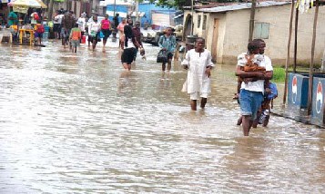
Figur e 2. Flooding in Aj egunle, Ketu ar ea of Lagos State
(Sour ce: The News, Oct 11, 2010)
Infection of sur face wat er and gr ound water leading to incr eased incidences of water -borne diseases such as Schistosomiasis (Ofoezie & Asaolu, 1997) is also pr evalent. Flooding also exposes r esidents to an impending cholera, diarrhea, malar ia, skin infections and other water-borne diseases epidemic
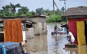
(Etuonovbe, A.K.,2011)(Figur e 3).
Figur e 3. Aj egunle-Ikor odu Flood in Lagos (Sour ce: Etuonovbe, A.K., 2011)
Encr oachment of r esidential and commercial developments into the floodplain of the dam as a r esult of false secur ity has not help matters. Based on the Federal Guidelines for Dam Safety, it is classified as Class 1 dam taking into consideration the height of dam, storage volume and potential downstr eam hazard (Federal Guidelines for Dam Safety, 1979).
2.0 HYDROGEOLOGY OF THE STUDY REGION
The location of a dam and the type of dam constr ucted is
based on factor s such as local geology, shape of the valley, local hydr ology, climate, availability of mater ials, manpow er and plant. For a river in any catchment, the flow is deter mined by climatic factors (particular ly pr ecipitation)
IJSER © 2012 http :// www.ijser.org
Inte rnatio nal Jo urnal o f Sc ie ntific & Eng inee ring Re se arc h, Vo lume 3, Issue 2, February -2012 3
ISS N 2229-5518
and the physical character istics of the dr ainage basin such as land use, type of soil, type of vegetation, ar ea, slope, elevation, orientation, type of dr ainage networ k, ext ent of indir ect drainage and artificial dr ainage (Wisler and Bater ,
1959; War d, 1967; Fetter , 1988). Geologically, the Ogun-
Osun River Basin to which the drainage basin of Oyan Dam
belongs is pr edominantly a basement complex in the north and coastal plain sand in the south but inter sper sed by Abeokuta, Ilar o and Ew ekoro Formations with some measur e of Alluvium(Aketoyon, et al, 2010) (Figur e 4). Located in the southwest r egion of Niger ia, it dischar ges through a chain of dendritic system (Idow u and Mar tins,
2007) into the Atlantic Coast via the coastal sedimentary
plains in Lagos State. The dam impounds Oyan River , a
tr ibutary of Ogun River cr eating Oyan Lake. Owing to the topography of the r egion which makes the upstr eam r ivers and tr ibutar ies dischar ge into it, the Ogun River r eceives water fr om Iseyin, Lanlate and other towns. The tr ibutar ies flow ing into Ogun River include Rivers Oyan, Ew ekor o, Opeji, Er edu, Iw opin, Sokor i, Owiw i, Aj ir e amongst others. The Ogun and Oshun River s in the basin dischar ge into Lagos Lagoon which flows into the Atlantic Ocean.
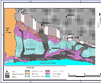
Figur e 4. Geology of the Ogun-Osun River Basin (Sour ce: Aketoyon et al, 2010).
Hydr ologically, Oyan Dam is located at a confluence of Oyan and Ofiki r iver s at an elevation of 43.3m above mean sea level. Short duration r ainfalls of less than tw o or thr ee hours ar e common occurr ence, contributing immensely to flooding in this tr opical r egion of the w or ld (Oyegoke and Oyebande, 2008).
The mean annual rainfall of the catchment is 1015.09m, out
of which rainy season accounts for 96.1% and the dry
season 3.9 %(Ufoegbune, et al, 2011). W ith eight(8) rainy months, the highest rainfall occur in June, July and
September which accounts for 47% of the total mean annual rainfall. The mean annual r unoff gener ated fr om the catchment is 822.2million cubic metr es. . The highest wind speed ar e found in the rainy seasons, Apr il (0.44m/s) while the highest r elative humidity occur s in July (89.5%).The mean monthly maximum and minimum temperatur e ar e obser ved in Apr il and December which ar e 35.20c and
26.10c while the minimum and maximum air temperatur e
occur in August(29.70c) and May and June(31.20c)
r espectively(Ufoegbune, et al, 2011). Furthermor e, the variability of r ainfall within the basin is within the range of
7%-13 %(Adeaga, 2006). The study of pr ecipitation data fr om synoptic stations in the basin cover ing 1944-2003 showed that station at Osogbo had the highest rainfall
stability(1.17) and the low est instability of hydr ological r egime(1.10) compar ed to the coastal stations which r ecorded the lowest rainfall stability (0.71) and the second highest instability of hydr ological r egime(1.65)(Adeaga,
2006). The ecological zone var ies fr om savanna to
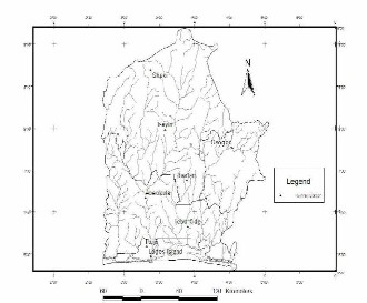
pr edominantly mangr ove and fr eshwater rainfor est (Idowu and Martins, 2007; Odumosu et al, 1999). The floodplains ar e fragile w etlands. The flow of the Ogun River netw or k is influenced by rainfall in upstr eam r egion, rainfall in the study r egion and downstr eam, water r elease fr om the various dams located upstr eam and high tide of Lagos
Lagoon. The southern end of the basin, which is Lagos State is dr ained by River Ogun in the centr e, Ona and Osun River s in the east and Yewa in the w est (Aketoyon, et al,
2010).
Figur e 5. Ogun-Oshun River Basin Drainge Netw or k, Southwestern Niger ia (Sour ce: Adeaga, 2006)
3.0 CURRENT MANAGEMENT PRACTICE AND FLOOD PROTECTION MEASURES
Dur ing heavy pr ecipitation in the r egion which ar e usually intensive, short-duration rainfall and appar ently w ith
IJSER © 2012 http :// www.ijser.org
Inte rnatio nal Jo urnal o f Sc ie ntific & Eng inee ring Re se arc h, Vo lume 3, Issue 2, February -2012 4
ISS N 2229-5518
contr ibution fr om upstr eam dams, the r eservoir of the Oyan dam quickly fills up. When the r eservoir level approaches 63m w hich seems to be the maximum design operational level, the gates of the dam ar e forced open to r elease excess water until the r eservoir level falls to betw een 58-62m. Owing to the sudden and rapid dischar ge of w ater fr om the Dam, the channels of the downstr eam r ivers r each flood levels which over flow their banks. Coupled with the sense of false secur ity which has encouraged infrastructural development in the floodplains along the downstr eam channels and disr egard for flood warnings, the impact of the flood assumes a catastr ophic dimension. Added to this fact is the lack of str uctural pr otective measur es for the entir e floodplain (Figur e 6). It is worr isome though that the Master Plan for Metr opolitan Lagos (1980-2000) and Ogun State Regional Plan (2005-
2025), which have zoned the floodplains and adj oining
ar eas as for est r eserves, conservation ar eas and buffer zones, have been j ettisoned by both pr ivate and public developer s.
Furthermor e, emer gency measur es taken by the gover nments of the affected states to evacuate and r elocate affected r esidents leaves so much to be desir ed. The conveyance channels downstr eam of the
Oyan Dam ar e not lined let alone built up for flood pr otection purposes. Also, maj ority of the communities in the floodplain have poor dr ainages which makes matters wor se. Without gainsaying, it is appar ent that the curr ent operational management of the dam is far below the minimum best pr actice r equir ed for a dam of such magnitude. The non-structural measur es for flood pr otection in form of flood w arnings and temporary evacuation is far fr om being adequate, let alone being effective.
4.0 HYDROLOGICAL MODEL FOR DAM
MANAGEMENT
The use of modelling to enhance dam operation and
management and mitigate flooding of downstr eam has been in use within the last two to thr ee decades. For Foz do Ar eia dam, flow for ecasting model has been applied (Mine,
1998) in combination w ith a rainfall-runoff model and a
hydr odynamic model which stimulat es the flow in the r iver r each (Tucci, 1978; War k et al, 1991; Villanueva, 1997). W ith the use of the models, the oper ational level was not exceeded using a flow for ecast w ith a lead time of 24 hours. Hence, downstr eam flooding was dr astically r educed. Likew ise for Str atton Dam, a hydr ologic model which
ser ves dual pur pose of simulating rainfall-runoff pr ocess in the water shed and flow-for ecast was used along w ith a flow r outing FEQ model which simulates flow hydraulics of Stratton Dam, Fox Chain Lakes and Fox River (Knapp et
al, 1991; Knapp and Ortel, 1992). Ther e r esults show ed that the ear ly r elease fr om the dam prior to the arr ival of flood upstr eam through the use of flow for ecast helped to r educe dow nstr eam flooding. The accuracy of the flow for ecast model depends lar gely in part on the number of rain gauges used to develop the model.
For the development of a hydr ological model for Oyan
Dam, pr ecipitation data fr om raingauge stations within its
catchment ar ea spanning considerable number of years
would be used. Pr eferably, extr eme, high-r isk pr ecipitation and some moderate-r isk pr ecipitation data which span some days would be valuable. Now that short-duration rainfall is a common phenomenon nationwide, data on this would be included. The eight synoptic rainguage stations
within the catchment ar ea which w ould be used include Ikej a, Lagos Island, Abeokuta, Ij ebu-Ode, Ibadan, Osogbo, Shaki and Isheyin.(Adeaga, 2006)
The Oyan Dam/River hydr ological model per forms two basic functions:
(1.) Estimates flow hydr ographs for ungauged tr ibutar ies/r ivers of the Ogun/Oyan Rivers upstr eam which serve as input into the Flood Routing Model, which is in line with Cor ps of Engineer Study(USACOE, 1984) and
(2.) When modified into a flow for ecast model, it
pr oduces flow for ecasts using near r eal-time data but fir st using past histor ical data to estimate a “pseudo-for ecast” for each historical flood that would be analysed. To make an oper ating decision for any day dur ing these histor ical floods, it is necessary to have :
I. know ledge of the antecedent str eamflow and oyan lake conditions occurr ing that day
II. an estimate of the flow for ecast that would have been available on that day
III. establish a r elationship between the flow
for ecasts and associated observed or r ecorded flow s
IV. the pr obability of under estimating or over estimating the flows of actual floods that occur
V. Recommended policy for operating the dams
for each alternative , based on antecedent conditions and for ecast data.
The model w ould be used for implementation of the ear ly r elease of stor age in the Oyan Dam in anticipation of flood event befor e arrival at the Dam.
IJSER © 2012 http :// www.ijser.org
Inte rnatio nal Jo urnal o f Sc ie ntific & Eng inee ring Re se arc h, Vo lume 3, Issue 2, February -2012 5
ISS N 2229-5518
0.5.
X = a weighting factor that var ies between 0 and
Constants a and n r eflect the stage dischar ge
char acteristics of contr ol sections
b and m = stage-volume character istics of the
section.
X = the r elative w eights given to inflow and
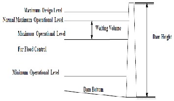
Figur e 7.Dam schematic operational levels for Flood
Contr ol.
Likew ise, it w ould allow for some lag time for safe water r elease fr om the dam w ithin acceptable level of r isk to dow nstr eam floodplain and provide waiting volume to contain the flood event (Figur e 7).
4.1 FLOOD ROUTING MODEL FOR DAM W ATER
RELEASE
Routing has been in use to pr edict tempor al and spatial variation of a flood wave as it tr averses a river r each and outflow hydrogr aph fr om a water shed (Viessman, 1989). The flood r outing model stimulates the hydraulics of the Oyan Dam, and associated rivers, and Oyan downstr eam channels and r ivers using momentum equations utilizing partial differ ential equations for unsteady flow. The flood
r outing hydr aulic model w ill take into consideration a wide range of histor ical and simulated flood conditions and potential oper ating schemes and w ould be utilised in pr oducing the outflow hydr ogr aph fr om Oyan Dam taking into consideration differ ent pr ecipitation and dam operation conditions. For the flood r outing model, two types of data ar e r equir ed namely physical and temporal data. The physical data includes channels and r ivers cross sections upstr eam and downstr eam of Oyan Dam. The temporal data include: inflow hydr ogr aphs, Oyan Dam gate oper ations and initial water levels. Past r ainfall model could be used and updated with new data. Using various floods with differ ent r etur n per iods would be useful in determining potential flood r isk of downstr eam floodplains depending on the various dimensions of pr otective structur es consider ed. The behaviour of a flood wave has been descr ibed by Muskingum in his method called Muskingum method(Viessman, 1989).It is states that the stor age in a r iver r each depend primarily on the dischar ge into and out of a r each and on the hydraulic character istics of the channel section expr essed as:
S = b/a [XIm/n + (1-X)Om/n] assuming m/n = 1 and b/k = K
This becomes: S = K [XI + (1-X) O]
Wher e K = the stor age time constant for the r each
outflow for the r each.
Assigning a r outine incr emental time time interval
Δt which var ies b etween K/3 and K, the
r esulting equation becomes

O2 = C0I2 + C1I1 + C2O1
Wher e subscr ipts 1 and 2 denote the beginning and ending
times for Δt and C0 +C1+C2 = 1
The limitations of the muskingum method w as over come by Cunge(1967) yielding r esults comparable with hydr aulic methods.
5.0 DAM OPERATION ALTERNATIVES AND STRUCTURAL PROTECTION FOR FLOOD MANAGEMENT
In or der to enhance pr otection of the affected floodplains, both str uctural and non-str uctur al measur es need to be implemented. The dam operation alternatives ar e on e of the several non-structural pr otection measur es that would be consider ed since it plays a significant, cr itical r ole in the
flooding of the downstr eam floodplain. Other non- structural measur es include flood zoning and emer gency flood alert and evacuation.
5.1 DAM OPERATION ALTERNATIVES FOR FLOOD MANAGEMENT
The dam oper ation alter natives include:
I. Open gates below maximum gate opening
dur ing intr a-stor m per iods whenever stages in the dam exceed the normal pool level
II. Open gates below maximally during intra-
stor m per iods whenever stages in the dam exceed the nor mal pool level
III. Open the existing gates below maximum gate opening pr ior to the flood using the flood for ecast model to estimate inflow using various scenar ios of one to tw o days lead time
IV. Open the existing gates maximally prior to the
flood using the flood for ecast model to estimate inflow using various scenar ios of one to two days lead time
IV. Follow alter native I but with normal pool level r educed.
V. Follow alter native II but w ith normal pool level r educed.
IJSER © 2012 http :// www.ijser.org
Inte rnatio nal Jo urnal o f Sc ie ntific & Eng inee ring Re se arc h, Vo lume 3, Issue 2, February -2012 6
ISS N 2229-5518
VI. Follow alternative III but with normal pool level r educed.
VIII. Follow alternative IV but with nor mal pool
level r educed.
Calibration and validation of the model would be done to ascer tain its effectiveness and applicability using tw o or mor e flood events using stage/dischar ge data.
5.2 STRUCTURAL PROTECTION FOR FLOOD MANAGEMENT
Structural pr otection for flood management includes dams, levees, dykes, canals, levees, r etention ponds, etc (Tucci,
1994). For Sacramento in United States, a combination of Folson dam and levees spanning several miles have been in use to confine floodwater s to the r iver netw or k and out of the floodplain wher e the city is located(Carter , et al, 2006). For the floodplains downstr eam of Oyan River Dam, feasibility studies into the best form of str uctural pr otection to pr ovide is necessary considering the huge capital expenditur es that w ould be involved which would have to take into consideration the level of pr otection to be pr ovided and the socio-envir onmental impacts as w ell. In the inter im, r elocation of affected citizens to safer ar eas may pr ove a tempor ary measur e, but a per manent solution is inevitable owing to the attractiveness of the floodplains for infr astr uctur al development.
6.0CONCLUSION AND RECOMMENDATIONS
Climate change and variability coupled with the tr aditional
operational method in use at Oyan River dam and the poor pr otective measur es have led to incessant flooding of the floodplains downstr eam of the dam. The ur gent need for a r obust pr otection system for the affected floodplain is r evealed by the enormous losses and impacts of the annual
flooding. A combination of both structural and non- structural pr otection measur es is r equir ed to alleviate the impacts of such flooding. The pr ovision of a proactive and pr eventive system in the use of hydr ologic model for flood- warning and hydraulic model for flow for ecasting is requir ed to enhance the oper ation of the dam and mitigate flooding downstr eam of the dam.
Failur e to pr ovide such pr agmatic pr otection system for the
floodplains and impr ove operation of the dam could pr ove disastr ous in the near futur e. The hydr ologic model would take into consideration the various operational alternatives mentioned while feasibility studies is r equir ed ascertain the
best for m of structural pr otection measur e to be put in place for affected floodplain. On the whole, dam planning and operation involves r esponsibility for the effects which may be pr oduced upstr eam and downstr eam of the dam
and as such a r obust pr otection system for the surr ounding floodplains should be taken into consideration.
This should apply to Feder al- and state-owned
infr astr uctur es such as dams acr oss the country hencefor th. Furthermor e, ther e is need to incr ease the density of obser vation/monitor ing stations and rain gauge stations along our rivers netw or ks and in each r iver basin especially along flood plain ar eas acr os s the nation with facilities for telemeter ing hydr ologic data. This w ill enhance the accur acy of model developed for hydraulic and hydr ologic pur poses and pr ovide lead time to avert flooding disasters. In conclusion, ther e is need to put structur es in place to enhance the usage of Oyan Dam for irr igation, water supply and hydr o-pow er gener ation pur poses which will enhance the socio-economic development of the flood plain and likewise help r educe flooding of the affected w etlands in general.
REFERENCES
1) Adeaga, O. (2006). Multidecadal Var iability of Rainfall and W ater Resour ces in Niger ia. Fifth
FRIEND W orld Conf., Havana, 2006.
2) Aketoyon, I.S., Ogundele, F.O. and Soladoye, O.(2010).
Character ization by Factor Analysis of
Chemical Faces of Gr oundwater in the Coastal Plain Sands
Aquifer of Lagos, South Western Niger ia. Int’l J. of
Academic Research. Vol. 2. No. 5, Sept., 2010.
3) Carter N.T., Ster n C.V. and Cody, B.A.(2006). Sacramento Flood Contr ol and Folson Dam: Recent Action and Curr ent Issues. Resour ces, Science and Industry Division, Oct. 6,
2006, Congr essionalService Report RL33682.
4) Cunge, J.A. (1967) “On the Subj ect of a Flood
Pr opagation Method”, J. Hyd. Res. IAHR 7(2), 205 -
230(1967).
5) Etuonovbe, A.K. (2011) Devastating Effect of Flooding in
Niger ia. FIG Wor king W eek 2011
6) Br idging the Gap betw een Cultur es Marr akech, Mor occo,
18-22 May 2011
7) Federal Guidelines for Dam Safety (1979) Pr epar ed by the Interagency Committee on Dam Safety, June 1979,
r eprinted Apr il, 2004
(http://www .fema.gov/plan/pr event/damfailur e/fema93.sht
m)
8) Fetter , C.W . (1988). Applied Hydr ogeology. Pr entice
Hall, Upper Saddle River , New Jersey.
9) Idow u, O.A. and Mar tins, O.(2007). Hydr ograph
Analysis for Gr oundwater Rechar ge in the Phr eatic
Basement Aquifer of the Opeki River Basin, Southw ester n
Niger ia. Asset Ser ies B(2007), 6(2):132-141
10) Knapp, H.V., Ortel, T.W . and R.S. Lar son. 1991.
Hydr ologic Modeling of the Fox River
IJSER © 2012 http :// www.ijser.org
Inte rnatio nal Jo urnal o f Sc ie ntific & Eng inee ring Re se arc h, Vo lume 3, Issue 2, February -2012 7
ISS N 2229-5518
11) Water shed. Illinois State W ater Survey Contract Repor t
518.
12) Knapp, V. and Ortel, T.W .(1992). Effect of Stratton Dam
Operation on Flood Contr ol along the Fox River and Fox Chain of Lakes, Office of Sur face Water Resour ces and Systems Analysis, July 1992.
13) Mine, M., 1998. Método determinístico para minimiza r o conflito entre gerar energia e
14) controlar cheias. Tese de Doutorado . Instituto de
Pesquisas Hidráulicas. UFRGS.
15) Obeysekera, J., Salas, J.D. and Shen, H.W .(1986). Normal
Operating Plan for the Valdesia Reservoir System. Department of Civil Engineer ing, Colorado State Univer sity, July 1986.
16) Odumosu T, Balogun Y.& Oj o. K (1999). (ed) Lagos
State in Maps, Rex Char les Publication,
17) Ibadan pp. 1-50.
18) Ofoezie, I.E. and Asaolu, S.O.(1997). Water Level
Regulation and Control of Schistosomiasis
Transmission: A Case Study in Oyan Reservoir , Ogun State, Niger ia. Bulletin of the W orld Health
Or ganization, 1997, 75(5), 435-441. W or ld Health
Or ganization.
19) Oyegoke, S.O. and Oyebande, L. (2008). A New
Technique for Analysis of Extr eme Rainfall for
Niger ia. Envir onmental Resear ch Jour nal 2 (1): 7-14, 2008
20) The News (2010). Sacked by Flood.
http://thenewsafr ica.com/2010/10/11/sacked-by- flood/
dow nloaded June 22, 2011
21) Tucci, C.E.M. 1978. Hydraulic and Water quality
simulation in a river ne twork. PhD dissertation Civil Engineer
Department Color ado Statr Univer sity. Fort Collins Co.
22) Tucci, C.E.M. (1994) Dams and Flood Contr ol,Institute
of Hydraulic Resear ch Univer sity Federal of Rio Gr ande do
Sul Porto Alegr e – RS Br azil
23)http://www.iph.ufr gs.br /cor podocente/tucci/publicacoes
/damsfloods.PDF
24) Tucci, C.E.M and Villanueva, A , 1997. Controle de
enchentes das cidades de união da Vitór ia e Porto União. CORPRERI, 117 p.
25) Ufoegbune, G.C; Yusuf, H.O., Eniola, A.O. and
Aw omeso, J.A.(2011). Estimation of W ater Balance of Oyan
Lake in the North W est Region of Abeokuta, Nigeria. British Journal of Envir onment and Climate Change, 1(1):
13-27, 2011
26) U.S. Army Cor ps of Engineers, Chicago Distr ict
(USACOE). 1984. Inter im Repor t, Fox River and Tributar ies, Illinois: Feasibility Report w ith Final Environmental Impact
Statement; Supporting
Documentation, Technical Volume B -- Hydr ology and
Hydr aulics
27) Viessman, W ., Gary, L.L. and Knapp, J.W .(1989) Intr oduction to Hydrology, 3r d Ed., Harper and Row Publishers, pp. 235-265
28) Villanueva, A O N, 1997 . Dynamic floodplains simulations: compound channels and wetlands. PhD thesis IPH-UFRGS (in portuguese)
29) War d, R., Robinson, M. (1990). Principles of Hydr ogeology. Thir d Edition. McGraw-Hill Book Company. UK.
30) War k, J. B.; Slade, J.E. Ramsbottom, D. M., 1991 . Flood
Discharge Assessment by the Late ral
Distribution Method. Report SR 277, Dez 1991. Hydraulics
Resear ch, W allingfor d
31)Wisler , C., Brater , E. (1959). Hydr ogeology. Second
Edition. John Willy and Sons Inc., Japan.
Department of Civil and Environmental Engineering, Univers ity of Lagos
IJSER © 2012 http :// www.ijser.org