International Journal of Scientific & Engineering Research Volume 2, Issue 11, November-2011 1
ISSN 2229-5518
Web-based Land Records System - The case of
Ghana
N.D. Tagoe, S. Mantey
Abstract— In Ghana, there is general indiscipline and lack of transparency in the land market. This is characterized by multiple sales of residential parcels, land encroachments and haphazard development. Land records form the bases of all land reforms and therefore regular online update of land records is essential.The objective of the web-based land records system therefore was to provide a quick, secure and transparent access to land records and land registration via the Internet and other communication devices. This will de-centralize the land registration process and thus reduce the workload on the land registration offices.This will also encourage land registration or legal parcel documentation due to the flexibility and simplicity of the system. The methods employed involve (1) providing GIS data access through MapObject and ODBC Driver, (2) integrating Google Earth (GE) with GIS
application using COM API: (3) importing GIS data into Google Earth: (4) linking GIS data with KML: (5) accessing external tabular data through ‘relate’ and (6) querying and visualizing land records online using Google Maps.The outcome of this study is a user-friendly web-based land records from which authorized users and subscribers can visualize and access a secured land records in the country. The new system will bring transparency and improve the way land records are maintained and administered in the country. The system will not only simplify the process of land registration and land records keeping, but will also provide many collateral benefits.
Keywords— Ghana, Google Earth, Land Records, Land Registration, MapObject, Visual Basic, Web-based GIS.
—————————— ——————————
1 INTRODUCTION
and dispute has been a major cause of conflict among in- dividuals, organizations and societies in Ghana. It was for
this reason that the Lands Commission was introduced to manage land transaction and provide a means of settling land disputes peacefully based on their records on the ownership of land. In 1986, the government of Ghana introduced the Land Title Registration Law to give certainty and facilitate the proof of title and to render dealings in land safe, simple and prevent frauds on purchase (PNDC Law 152).
This makes records kept by the Lands Commission a very im- portant document in the country since it is the only means by which one can defend his/her land. It also serves as documents for loan acquisition from banks and other financial institu- tions.
However, the mode in which the records are kept and re- trieved makes it almost impossible for the organization to de- liver its duties. There are no reliable land records or registra- tion of land rights in most parts of Ghana [1]. Earlier study by [2], revealed that, ownership rights and holding of lands are not properly documented and as a result, the enormous assets cannot be turned into capital, which create the wealth of na- tions.
Besides, in cities and peri-urban areas where the demand for land is high, there has been high incident of land en- croachment, multiple sales of land and conflicting claims over
————————————————
N. D. Tagoe is currently an assist. lecturer at the University of Mines and
Technology, Department of Geomatic Engineering, Ghana.
S. Mantey is currently a lecturer at the University of Mines and Technolo- gy, Department of Geomatic Engineering, Ghana.
boundaries. These have in turn resulted in land disputes, con- flicts and litigation between stools, skins, families and indi- viduals [3], [4].
The routine involved in the confirmation and verification
of land documents is complex and discouraging. As a result, people fail to verify these documents before making the actual purchase which also results in fraud and land disputes. Banks and other financial institutions also find it difficult to validate land documents submitted by their business partners due to the lack of a central server for all documents related to land parcels in the country.
To combat the weaknesses in the current system of land records, the web-based land records system has been devel- oped. The system which permits remote storage and query of data seeks to stimulate economic development and promote social stability by improving security of land tenure, simplify- ing the process for accessing land and making it transparent, efficient and developing the land market as well as promoting prudent land management.
Land records form the base for all land reforms and there- fore regular online updating of land records is essential.
2 LAND TENURE SYSTEM IN GHANA
In Ghana, the customary land tenure system placed Allodial titles in heads of clans, families or communities in trust for their subjects. It is a source of wealth for the clan or families and has important social and religious implications. Land te- nure in Ghana and in many parts of sub-Saharan Africa has evolved, from the era before and through the colonial past, with a dual system: the formal and the informal. The formal tenure arrangements based on English Common Law were
IJSER © 2011
http://www.ijser.org
International Journal of Scientific & Engineering Research Volume 2, Issue 11, November-2011 2
ISSN 2229-5518
applied mainly to facilitate access to land among the expa-
triate community, while existing customary laws guided the indigenous population in the acquisition and use of land in their communities. These tenure arrangements continue to have very far-reaching effects on land markets in Ghana today [5].
The pace of urbanization in Ghana has been quite rapid. In
1948, the ratio of the urban population to the total population was 13%. This increased to 31% in 1984 and 44% in 2000. In
1960, about 40% of Ghana’s population lived in the three larg- est cities – (Accra, Kumasi and Sekondi-Takoradi) and a fur- ther 9% lived in the next four (4) agglomerations: Cape Coast, Tamale, Koforidua and Winneba. Indeed, Accra alone accounts for over 40% of the total urban population. Thus, despite the large increase in the number of urban localities from 39 cities in 1948 to 364 cities in 2000, approximately half of the coun- try’s population lived in the seven (7) largest urban areas [6].
This rapid urbanization brought about pressure in the de- mand for land for housing and other forms of investments in the urban centres such as Accra. In response to demand for urban lands, the process of land supply under the family land tenure has changed from giving farming use rights to urban land use rights. This means that urban growth leads to the creation of individual property rights in communal lands [7].
The result of this pressure coupled with greed on the part
of land owners led to a chaotic land market and its resulting costly litigations and in some cases lost of investment or lives. There are about 80 000 land cases pending before the high courts in Accra alone [8].
3 ATTEMPT TO SANITIZE THE LAND MARKET
There were several attempts by succeeding Governments to sanitize the land market and to overhaul the land tenure sys- tem. The Land Development (Protection of Purchasers) Act
1962 (Act 2), on the other hand, was designed to ‚protect pur- chasers of land and their successors whose titles were found to be defective after building has been erected on the land‛.
The Land Registry Act 1962 (Act 122) went a step further to try and protect purchasers of land against greedy landlords. Due to the government’s cautious approach to traditional au- thority, those laws did not change the existing land tenure sys- tem; they operated within the scope set by the rules of custo- mary law. This limitation notwithstanding, such laws marked the state’s most forceful entry into the politics of land owner- ship and control and its attempt to gradually take over the management of customary lands in the country [9].
The chaotic nature of the land market continued despite at-
tempts by successive Governments to intervene. The 1970s also saw another attempt at streamlining the market. In 1986, the Government of Ghana enacted a Land Title Registration Law (PNDC Law 152) to remedy the weaknesses in the system of registration of instruments that existed then. However the
implementation of the formal system has been very slow. In
June 1999, the Government issued the National Land Policy (NLP) which was subsequently amended in 2002 [10]. The problems in the land market situation persist despite several attempts by successive Governments of Ghana.
As noted by a former President of Ghana:
‚… We furthermore found that, in spite of some positive achievements – including the introduction of maps, deeds and registry systems, and the release of land for public infrastruc- ture purposes like schools, hospitals and roads – the practical benefits of the Lands Commission and other delegated author- ities to the silent majority (i.e. the rural, peri-urban and urban poor, the disabled, the unemployed, the low and middle- income earners, etc.) were not evident. It also became evident that interventions by the Lands Commission, such as compul- sory acquisition of land and non-payment of compensation, have resulted in social unrest, displacement of villagers, and landlessness in affected communities. Land administration in Ghana is bedeviled with the multiple sale of parcels of land by different parties claiming ownership of the same parcel of land, the poor use of compulsory acquisition powers by gov- ernment agencies to acquire various tracts of land for which they are unable to pay compensation, weak management, both public and customary, and quite recently, the menace of land guards. As of July 2004, there were about 66 000 land disputes before the courts, due to the inability of traditional authorities to identify the extent of land boundaries‛ *11].
4 THE LAND ADMINSTRATION PROJECT
Against the background of the problems associated with land tenure and land reforms introduced by earlier Governments, the Government of Ghana in 1994 introduced the Land Policy Bill that culminated in the Land Administration Project. The overall goal of the project is to consolidate and strengthen land administration and management systems for efficient and transparent service delivery. This will be achieved through reviews and enactment of appropriate land administration laws and regulations, capacity building for land sector agen- cies and land owners. Specifically the project will:
Complete the drafting of the land and land Use Planning Bills and support the preparation of Legislative Instru- ments for the Land Acts; Land Use and Planning; Lands Commission and the Office of the Administration of Stool Lands.
Improve the land registration and title system in terms of security and reduction of time for service delivery.
Improve the real property and mapping system.
Undertake street naming and addresses.
Increase revenue generation by land agencies and district assemblies.
IJSER © 2011
http://www.ijser.org
International Journal of Scientific & Engineering Research Volume 2, Issue 11, November-2011 3
ISSN 2229-5518
Improve capacity of land sector agencies and private sector providers [12].
These reforms notwithstanding, the land market continue to be chaotic. People are still being swindled intentionally by land owners. One reason is that the process involves so much bureaucracy. Information relating to land ownership is not readily available to prospective buyers. Buyers find the bu-
reaucracy cumbersome.
5 OBJECTIVES
The objectives of this system are to:
(1) Provide a quick, secure and easy way of registering land
parcels via the Internet and other communication devices. (2) De-centralize the lands registration process and lessen the
burden and workload on the land registration offices.
(3) Encourage land registration or legal parcel document ac-
quisition due to the flexibility and simplicity of the system. (4) Introduce a remote land parcel document verification and validation via the Internet. Hence any device with Internet access may be able to communicate with the central land registration database and pullout information relating to
land parcel of interest.
(5) Feature a 3D representation of land parcel and its proper- ties by merging GIS data into Google Earth using
‚shape2earth‛.
(6) Provide a stepping stone for introducing the emergency response system which is concerned with keeping track of the current residents of citizens in the country for the pur- pose of tracking, crime limitation and package delivery policies.
6 MATERIALS AND SOFTWARE REQUIRED
For the system described above to be able to exist and deliver it purpose, the following are required:
(1) VISUAL STUDIO (PROGRAMMING ENVIRONMENT): This is the opening tool for developing applications that targets the .Net Framework. The .Net Framework provides developers with wide range of tools such as compilers, de- buggers, programming languages and execution engines. It features many programming languages such as Visual Ba- sic (VB), C++, J#, C# etc. making VISUAL STUDIO an all in one programming package for developers. The language of choice in this study was VB. It is compatible with COM and ActiveX controls and provides unlimited extensions for applications developed with VB.
(2) MAPOBJECT: The mapping component software created by Environmental Systems Research Institute, Inc. (ESRI), to allow mapping functions to be included in applications developed in a variety of programming environments. MapObject software is a set of mapping software compo-
nents that lets developers add dynamic mapping and geo- graphic information system (GIS) capabilities to existing Windows applications or to build custom mapping and GIS solutions.
(3) GOOGLE EARTH COM API OR PLUGIN: The Google Earth Plug-in and its JavaScript API let you embed Google Earth, a true 3D digital globe, into your applications. Using the API you can draw markers and lines, drape images over the terrain, add 3D models, or load KML files, allow- ing you to build sophisticated 3D map applications. Google Earth is mainly used to display Geospatial Data on a visu- ally appealing framework.
(4) SHAPE2EARTH: The incorporation of Google Earth into the application requires ““shape2earth””. ““shape2earth”” is the easiest and most powerful way to view GIS data in Google Earth by converting any shapefile to KML and also provides thematic symbology (colour code) to converted shapefiles.
(5) COMPUTER SYSTEM WITH OPERATING SYSTEM: This serves as the platform for hosting all the other require- ments. The application can be split into client side and server side which may require more than one of computer system and operating system.
7 METHODOLOGY
The methods employed include;
7.1 Accessing GIS Data through MapObject and ODBC Driver:
Using this component, the GIS data was accessed in conjunc- tion with an external database called SQL and Oracle. The programming environment provides the necessary drivers for accessing various database files, which includes Open Data- base Connectivity (ODBC) and ActiveX Data Object (ADO).
7.2 Integrating Google Earth (GE) with GIS Application using the COM API:
Google Earth rendering window was embedded in the appli- cation using GoogleEarthAirlines. The GIS data was then ex- ported to the rendering window using a modified version of
‚‚shape2earth‛‛. The application features 3d rendering of buildings and parcels which enhances visualization of data. The application is also able to act as a Google Earth with all the controls and also host the local GIS data (shapefiles of the area of study) as well as support interaction between the two components.
7.3 Importing GIS Data into Google Earth:
GIS Data was imported into Google Earth. Google Earth is mainly used to display Geospatial data on a visually appeal- ing Framework. Usually Google Earth does not allow query-
IJSER © 2011
http://www.ijser.org
International Journal of Scientific & Engineering Research Volume 2, Issue 11, November-2011 4
ISSN 2229-5518

ing or editing of GIS data. However the new Google Earth API makes it easier to perform such functionalities. The new Google API features the ability to click on a location and gen- erate the coordinate of that point. Its integration with Goog- leEarthAirlines enhances this functionality.
7.4 Linking GIS data with KML:
GIS data was linked with KML to render the GIS Data. In or- der to get the GIS data into Google earth, modified version of
‚shape2earth‛ was used. This converts the GIS data into KML and then writes the XML file that links the two files together. This makes it possible to access Geospatial data by clicking directly on Google Earth. The GIS data is therefore handled by the MapObject and the result of its operation is converted to KML by ‚shape2earth‛ and rendered in the Google Earth Window.
7.5 Accessing external tabular data through ‘relate’:
‚AddRelate‛ was used to join data file to an attribute table for the duration of a session. This means that the application can be provided with any external database file of a supported format to be linked to the attributes of the GIS (shapefiles) da- ta, hence making the attribute table of the GIS data (shapefiles) dynamic and unlimited.
7.6 Online visualization using Google Maps:
In order to incorporate Google map into the application a web browser was built and set to navigate to the Google maps. Google map provides interesting online map visualization for free. Google map however does not provide any land parcel visualization but may have the correct route and properties which can be used to identify a certain land parcel.
7.7 General work flow:
The application works by holding, saving and relating the two data types (Spatial and Non Spatial) together hence featuring the geo-referenced visual attributes of the spatial data together with the non spatial data.
Spatial data: These are geographic data of the area (Sunyani, Tarkwa, etc) showing land parcels, roads and buildings. The geographic data can be obtained by digitizing a map of the study area and geo-referencing it in GIS applications like Arc- View or ArcGIS.
Non Spatial data: These are details not represented on the spatial data. They may include specially designed database with details of every parcel on the spatial data such as Owner’s name, Date registered, Photo ID of owner, Home and Work address etc. The dynamic nature of the application al- lows it to be linked to any database at any time.
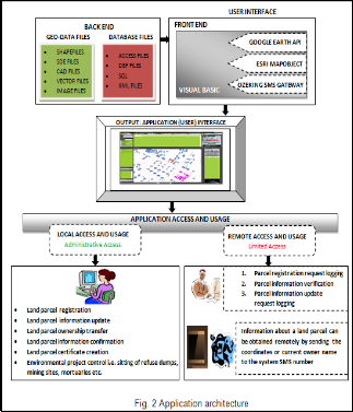
Application development: The application (Land Records System) was developed using VB, MapObject and Google Earth API as stated earlier in the methods. The back end of the application is shapefile or SDE files, Database file (DBF, Ac- cess, SQL etc) and image files. The front end (Interface) is de- veloped using Visual Basic, MapObject, Ozeking sms gateway and Google Earth API.
IJSER © 2011
http://www.ijser.org
International Journal of Scientific & Engineering Research Volume 2, Issue 11, November-2011 5
ISSN 2229-5518
8 RESULTS AND DISCUSSIONS
The application has been developed successfully by adding the web dimension to land records System. There are two Lo- gin modes of the application, they are;
(1) Administrator mode (Full privilege mode) and
(2) User mode (restricted mode)
With this application authorized users and subscribers can
Perform spatial and non-spatial queries
Update newly registered parcels
Add new registered parcels by coordinates and by on- screen digitizing
Update and process land records
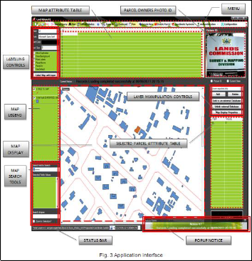
The Web-based land records system provides a user-friendly standalone application involving spatial details without the need of desktop GIS software like ARC/INFO, ArcView and ArcGIS. The application’s user interface is shown in Fig. 3. When any parcel is clicked, the details are shown along with the non spatial information of the parcel.
On the menu bar are the following:
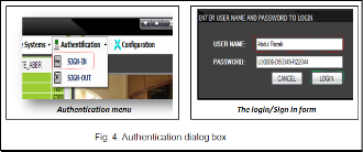
Authentication: This is a drop down menu that holds the “sign-in and sign-out” buttons (see Fig. 4). The application may lunch in a limited version when the user has not signed in. In this case the application limits its functions to only load- ing and displaying map data. Functions like printing, editing and all the administrative tasks are inaccessible until the user signs in using the sign-in button. After signing-in, the user can also sign out to return the application to its limited version mode. The printing of ownership certificate with the applica- tion requires the user to sign in because the certificate comes out as signed and accepted by the lands Administration offic- er, which is the name of the current user. So if you sign in, all printed certificates will have the user’s name as the Land Ad- ministration officer who accepted and registered that parcel. Hence it is essential for the user to keep his/her login creden- tials secret so that no other person can issue certificates in his name with the application.
Spatial query: This button brings out a window that allows the user to perform spatial analysis on the map (current layer).
IJSER © 2011
http://www.ijser.org
International Journal of Scientific & Engineering Research Volume 2, Issue 11, November-2011 6
ISSN 2229-5518
The Window allows the user to set some conditions under which a parcel will be selected. All the parcels that fulfill the condition will be highlighted on the map. For example all par- cels that intersects with a rectangle drawn on the map display. Highlighted parcels can be exported as new shapefiles, thus making it possible to truncate a larger map into smaller one
consisting of only the area of interest.
Find: The find tool allows the user to click on a parcel on the
map display and display it information. It is used for a quick search.
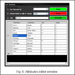
Edit attributes: This brings out the attribute editor table which allows the user to edit the maplayers attribute table as well as any other external database linked to the attribute table (see Fig. 6).
Zoom in: This activates the zooming function of the map. The user can click drag to define a zoom extend. The user can also click on the mapdisplay to zooming and center around the mouse click location.
Zoom out: This activates the zoom out function of the map. The user can double click to zoom out to full extend or simply click on the mapdisplay to zoom out.
Pan: This activates the pan function of the map display. It allows the map to be paned or moved to bring the area of in- terest into focus. Its effect is only visible when the map display has been zoomed in.
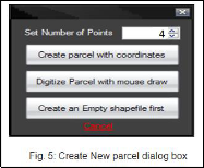
Creat new: The application allows the user to create new po- lygon (parcel) by entering the coordinates of the polygon points, create new polygon by drawing it on the map display and create a new empty shapefile (see Fig. 5).
Delete parcel: This button allows the administrator to delete a parcel or records from the map. When the administrator acti- vates the “DELETE BUTTON” and clicks on the on any par- cel on the map display, the selected parcel highlights, blink and prompt the user to whether he/she wants to continue the deleting process. If the yes button is clicked by the user, the parcel or polygon is deleted from the map layer.
Coordinate system: This is a dropdown button the present the user with some options regarding coordinates and coordinates system (see Fig. 7).
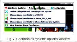
The options shown in Fig. 7 include:
Creating a shapefile with UTM projection system – This allows the user to project, export and save the current map layer with the .prj (projection) file attached to it.
Changing the layer coordinate to UTM 30N: This projects the current layer to UTM zone 30N (Ghana) coordinate system ‘on the fly’
Chaninge layer coordinates to Accra_TM_1_NW: This also projects the current layer to the Accra_TM_1_NW projection system.
Changing Layer coordinate to Ghana National Grid: This projects the current layer to the Ghana National Grid system.
View Selected Shape coordinates: This displays the
coordinates of the currently selected shape.
IJSER © 2011
http://www.ijser.org
International Journal of Scientific & Engineering Research Volume 2, Issue 11, November-2011 7
ISSN 2229-5518
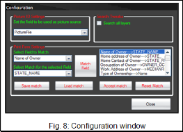
The Configuration window (in Fig. 8) is used to configure and reconfigure the application to match the current database in use. The user can then save the rematched settings and load it back any time the same external database file is used in the application.
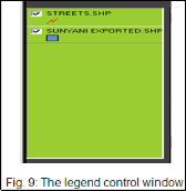
The legend control (see Fig. 9) displays the name and symbols of each map layer loaded. The user can turn on and off the visibility of each of the layers by checking and un-checking the checkbox in front of the layer name on the legend.
A double click on each of the layer names will launch the Map display property window which allows the user to change or customize the rendering style of the map display i.e. color, outline color and size, fill color and size etc.
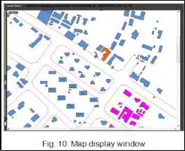
The Map dispay window (see Fig. 10) is the main window that shows the visual display of the spatial data/layers on the map.
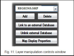
With the layer manipulation controls (see Fig. 11) the adminis- trator is able to add and delete layers from the map.
The administrator can also link and unlink the current layer with and external database file using the link to external data- base and unlink external database respectively.
The Map Display properties button allows the user to set the renderer style of the current layer on the map. It launches the map display Property window which allows the user to change the renderer style.
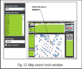
The Map Search tool presents the user with controls that al- lows the user to run inbuilt query statements on the map layer. Land parcels that fulfil the query highlighted on the map display window.
In Fig. 12, the user runs a query that searches for a parcel with
the name “PID 102”
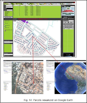
Google Earth Synchroniser: The Google Earth synchronizer button exports any selected or highlighted parcel for visualiza- tion on Google Earth (see Fig. 13 and Fig. 14). It does this by creating an array of coordinates of the selected parcel and creates a Google Earth Polygon KML file with it, which Loads into Google Earth automatically. The exported polygons are given a default Extrude height of 30 (suitable for countries, states etc). However this can make the exported parcel very
IJSER © 2011
http://www.ijser.org
International Journal of Scientific & Engineering Research Volume 2, Issue 11, November-2011 8
ISSN 2229-5518
long and difficult to view on Google Earth in case the parcel size is very small (towns, cities, farms, buildings etc.). There- fore it is recommended that the user adjusts the value of the
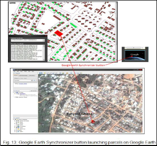
‚EXTRUDE HIEGHT‛ to a value that suits the size of the par- cel on the configuration form before exporting the parcel for visualization on Google earth.
centre or boundary coordinates of a parcel to the application sms number (the number refers to the SIM number in the GSM Modem used). When the application receives the sms, it processes the content of the message by running a search query with the content of the sms. The application then replies the sender with all the information about the parcel with the owner’s name or coordinates equal to the content of the sms received. As a result, anyone interested in making land trans- actions will have to acquire the current owner’s name or coor- dinates of the land parcel in question and send it to the sys- tem’s sms number. The information returned by the System may include;
Current username
Parcel location(City, Town, Street etc)
Parcel coordinates(Boundary and Centroid)
Contacts of current owner (Telephone No., Home Address, Work Address, etc.,)
Previous owner or original owner
Parcel size and locality type( for Residential, Educational,
Recreational, Industrial, etc)
Being able to access this information on-the-fly means that the sender will be able to determine whether he/she is dealing with the right owner or parcel.
Ownership transfer is also accomplished by sending the current owner’s parcel code (Secret password) and some de- tails about the new owner to the system Registration SMS number (multiple modems may be used for registering and verifying data). However this does not grant the new user full access to the land until he/she completes the registration process at any lands administration office where his photo ID and other details such as thumb prints will be registered for security purposes.
The application can forward all incoming calls to a specific number, this implies that one can voice chat with workers at the lands administration office when necessary.
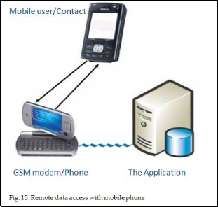
Remote data access with Mobile phone: As an application geared toward preventing land disputes, frauds and encourag- ing land parcel document verification and registration, it has a remote data access mechanism that makes it possible for its objectives to be met. This mechanism allows anyone with a mobile phone to send either the name of parcel owner or the
IJSER © 2011
http://www.ijser.org
International Journal of Scientific & Engineering Research Volume 2, Issue 11, November-2011 9
ISSN 2229-5518
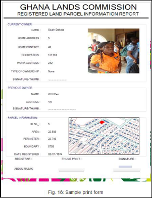
Print: this brings out the print form used for printing land parcel registration certificates (see Fig. 16).
9 CONCLUSION AND RECOMMENDATIONS
This study seeks to bring to the attention of all stakeholders as a matter of urgency, the need to have all information on land documented. This at the moment is being undertaken by the Land Administration Project. However from the studies, it has been observed that unscrupulous land owners will still swin- dle the public before one may find out. This project seeks to make information on land readily available to people interest- ed in acquiring land through mediums such as the Internet. This will in the long run reduce costly litigation, because one will be aware of the status of land being bought or leased.
Qualified land registration staff and surveyors must be available since the maintenance of the land registration system depends heavily on competent staff. Although education and training can significantly help, an existing core of qualified professionals is vital to begin the process and to assist in the training effort.
Only authorized land registration staff should have access to the administrator password and be allowed to add and edit land parcel information in the system.
ACKNOWLEDGMENT
The authors wish to thank Mr. Abdul Razak for his enomous support during the coding of this application software.
REFERENCES
[1] Kwesi, E.A.A., Mantey, S., and Aduah, M.S., ‚Land Compensation in the Oil and Gas Regions of Ghana-Challenges involved and the role of the Surveyor‛, The Ghana Surveyor, Special LS Division Seminar
2011 Edition, pp. 9-16, 2011.
[2] Kuntu-Mensah, P., ‚On the Implementation of Land Title Registra-
tion in Ghana‛ ISSER, University of Ghana, Accra Ghana, Technical
Publication # 14, pp. 30, 2006.
[3] Kasanga, R. and Kotey, N. A., ‚Land Management in Ghana: Build- ing on Tradition and Modernity‛, IIED, London, 2001.
[4] Dotse, J., ‚The Map as an Effective Tool in Land Administration — Resolution of Disputes, The Land Surveyor’s Perspective‛, The Ghana Surveyor, pp. 27-32, 2003.
[5] Aryeetey, E., Alhassan, R.M., Assuming-Brempong, S. and Twerefou,
D.K., “The Organization of Land Markets and Production in Gha- na”, ISSER, University of Ghana, Accra Ghana, Technical Publication #
73, pp. 13, 2007a.
[6] Anonymous, ‚A Study of Land Tenure in Urban Areas‛, Project Re- port, Water Aid, Ghana, pp. 24-25, 2009.
[7] Mends T.M and Meijer J., ‚Issues on Urban Growth: Customary Title and Informal Settlements‛, 5th FIG Regional Conference Accra, Ghana, pp. 7, March 8-11, 2006.
[8] Kotey, N.A.,‛Alternative Dispute Resolution (ADR)‛, Speech delivered before the Brong Ahafo Regional House of Chiefs, available at www.ghanaweb.com, 2003. [Accessed 17/04/2011].
[9] Aryeetey, E., Ayee, J.R.R., Ninsin, K.A. and Tsikata, D., ‚The Politics
of Land Tenure Reform in Ghana: From the Crown Lands Bills to the Land Administration Project” ISSER, University of Ghana, Accra Ghana, Technical Publication # 71, pp. 30, 2007b.
[10] Kuntu-Mensah, P., ‚On the Implementation of Land Title Registra- tion in Ghana‛ ISSER, University of Ghana, Accra Ghana, Technical Publication # 14, pp. 30, 2006.
[11] Rawlings J.J., ‚Challenges of Land Tenure and Reform in Africa‛, Address by Jerry John Rawlings, Former President of Ghana African Presidential Roundtable, Germany, available at http://jjrawlings.wordpress.com/2009/04/30/challenges-of-land- tenure-and-reform-in-africa/, April, 2009. [Accessed 17/04/2011].
[12] Anonymous, ‚Land Administration Project Website‛, www.ghanalap.gov.gh, 2011. [Accessed 17/04/2011].
IJSER © 2011
http://www.ijser.org