International Journal of Scientific & Engineering Research, Volume 4, Issue 10, October-2013 289
ISSN 2229-5518
The computing tools to assist with the
restitution of a heritage building.
Dr KACHER Sabrina
LVAP (Laboratoire Villes Architecture et Patrimoine), Algiers Algeria
EPAU (Ecole Polytechnique d’Architecture et d’Urbanisme), Algiers, Algeria
KEY WORDS: Mahkama, Ottoman Period, Almoravide period, 3D restitution, architectural photomodeling
Abstract — Nowadays when we restitute a heritage realization it doesn’t means that we will restitute only its formal shape or its spatial organization, but it also used as an activation element of student curiosity, scientist, or interested
This article tackles the particular question of the computing tools applied to the heritage domain. It concerns the presentation of the results obtained during restitution of an extension of the great mosque of Algiers. This extension is called the “mahkama” or “court house” which is a nearest part of the original great mosque. This restitution has been done in a pedagogic environment with post graduated student in architecture.
To make the restitution, three important phases have been done. The firt one concerns the contruction and the definition of the monography and the historical part of the building. The second one concerns the architectural survey with differents tools as the theodolite, photographic images. And the third one concerns the 3D laser survey. This part have been done in association with the student of the ENSA of Paris La Villette.
Index Terms— digital restitution, heritage realisations, photomodelling,
everal studies have shown that the restitution process is very important to capitalise and transmit knowledge in several domains such as the scientific domain, pedagogic field or even in the
tourist way.
The work presented in this paper have been done in a
pedagogic environment with post-graduated student
of the LVAP laboratory of the EPAU. Students made
surveys and a monography of a building belonging to
the Algerian heritage. The objective of the work was to
allow student to discover and to be familiarize with
the tools. This work has been done during a university
year and stats with a monograph and a historical
study of the restituted building.
To restitute the building several tools of 3D modeling
and rendering have been used.
This paper is structured in two mains parts. The first
part concerns the historical study to present the
heritage particular character of the restituted building.
The second one concerns the presentation of the
various tools used restitute the choose building.
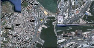
2. Geographic situation [5]:
The great mosque of Algiers is situated in the lower
Casbah (Figure 1). The casbah usually called « El
Kasbah » in arabic « la citadelle » in french and was
added to the world heritage list of the Unesco since
1992. The original city was built by Bologhine Ibn Ziri
over the structural failure of the Romain city called
“Icosium”.
It is situated in the Beni Mezghena area. The original name of the city given by Bologhine was because of the small islands faced the coast of the Algiers city à that time and their were linked to the city to constitute its actual jetty [4]. The “Algiers” means group of small Island “djozor” in Arabic.
The casbah is situated in a slopped site oriented toward the sea and is divided in two parts.
The “lower casbah” is situated between the sea coast and the bab el oued – bab azzoun road.
The “upper casbah” situated between the bab el oued
– bab azzoun axe and the “citadelle”. The upper part
was bordered by “ramparts”. Nowadays these
ramparts were changed as roads.
The lower part of the Casbah undergoes the most
important changes during the various historical
period and their modifications especially the French
period. The most important military opening
(Haussmann principles) were edified in this part of
the Kasbah [2].
Such as the expension of the circulation roads and the
edification of places such as the “matyrs” place and
the high-rise block of Socard. Nevertheless the lower
Casbah keeped some of the oldest realisations which
stay particular witnesses of their period.
The great Algiers mosqu and its dependences belongs
to these kind of realisations.
IJSER © 2013
International Journal of Scientific & Engineering Research, Volume 4, Issue 10, October-2013 290
ISSN 2229-5518
3. PART 01 ; THE RESTITUTED REALISATION :
As written before, the great Algiers mosque is one of the most important building of the lower Casbah. We will focuse on the “Mahkama” or “Dar El Kadi” which is a small space used to make and apply the public justice at that time.
In general the studies and research works related to the lower casbah studied the great mosqu but the mahkama which is an appended building to the mosque was not studied. For this we chose to restitute it because it is an important part of the mosque from a spatial and a social point of view.
The historic presentation that will followed will be devided in two parts. The first one concerns the presentation of the great mosque and in the second part we will present the mahkama.
3.1 The great mosqu :
The great mosqu was built by the Almoravide
« Youssef Ibn Tachfin ». the minaret or the prayer
tower was built by the zianide sultan abu Tashfin in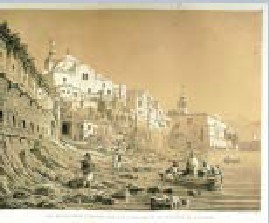
1324 [1].
The historic studies reveal that the justice cases were studied in this place but the results and the verdict were known in the great mosque space.
At that time most several mosque possess a “court house” part where justice cases were treated. The size and the location of the court house was depended of the size of the mosque.
So the Mahkama is an appended building to the Algiers great mosque which is one of the oldest mosque in Algiers city.
The prying room, without central dome, is “hypostyle”. The columns are linked by big arcs. The “mihrab” is decorated by columns and ceramics. The minaret is
A handle with three-brass balls with decreasing thickness overcomes the minaret. The outside gallery is not original and was added in the French period. More precisely it was added in 1836. Its marble columns (Figure 3) including floral motives are from the Sayida mosqu which was located in the matyrs place. The roof of the great mosque was recovererd with red tiles [8].
It is constructed with stones, bricks and wood. The decorative inside was made by ceramic and wood.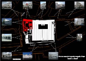
The great mosqu is situated in the « La marine »
(Figure 3) street and is the oldest mosqu in Algiers. Its
constitute with the Great mosque of tlemcen and the
great mosque of Nedroma the only witness of the
Almoravides dynasty today.
The building is in rectangular shape and is covered by
a double roof cover with tiles as all the almoravides
mosque.
We access inside the building by a portico oriented
given to three entrances in the wall oriented toward
the north direction. The courtyard is surrounded with
porticoes which some of them constitute the extension
of the nef of the prying room.
The prying room possesses sideway entrances and is
divided in eleven perpendicular naves to the qibla
wall in five bays.
The multilobes arcs are parallel to the mihrab and
constitute sequences with moorish arch which are
perpendicular and are based on rectangular and cross
pillars.
The construction of the great mosque happens
approximatively to the Ziride period eleventh century
IJSER © 2013
International Journal of Scientific & Engineering Research, Volume 4, Issue 10, October-2013 291
ISSN 2229-5518
because over its minbar is written 1096. After that the great mosque knows several modifications but keeps the spatial organization and the structural elements from the Almoravide period shared with the tlemcen mosque and the Nedroma mosque.
The stratigraphic studies of the great mosque shown important phases :
• Medieval phase
• Ottoman phase
• French phase
• Modern phase
3.2 The Mahkama :
When we combine the differents historic documents founded in studies about the great mosque and the mahkama, the initial restitution have been done. According to the founded information, the students restitute the map and the elevations of the various period and the modifications that happens in the mahkama.
We do not possesse a lot of documentations about the Mahkama, then we supposed that the mahkama have been construced during the Ottomane period. Because in the map drawing by Albert Devoulx [6], were the great mosque was also represented, the military modifications are represented, it was in 1838.
These modifications concerns the alignment lengthwise the marine road and then the modifications in the mahkama (Figure 4) [7].
So from this map, students suggested the main hypothesis that allow us to reconstitute the main room of the mahkama )Figure 4). These hypothesis concerns the composition in three parts of opening rooms to constitute a whole group of spaces.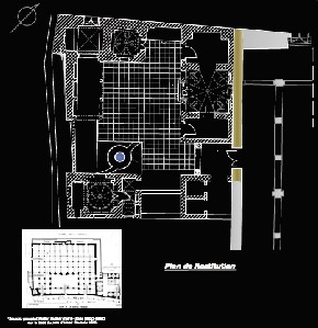
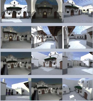
We decided to restitute the building as he exist (Figure
5). We choose this way because the main original
building is still exist. Their have been some
modifications but their was not fondamentory changes
when we compare them with the original building.
And it was very difficult to restitute and to identify
the various steps of the modifications that happens in
the mahkama because there was not a lot of
documentation about the building rather thant the
great mosque.
The restitution happened in several steps ;
4.1 Step 1 ; the manual survey
In this step several tools have been used.
The range-finder or remote rendering with laser
pointer, the theodolite and the decameter.
The decameter ; we use it as a measure tape, it allow
student to make a survey of the building with
traditional method. It allow us also to calibrate the
distometre (range finder) to check the first recovered
measures.
The theodolite; this tool allow us to recover some difficult measures more specifically the measures of elements situated in the upper parts of the building.
The range-finder : allow student to recover distances quickly.
All these tools allow students to restitute the building at the beginning in 2Dimensions. Students restituted a general and a global view of the building and identified the limits of the building.
But most of these measures were kept inside the building ot outside the building. To recover the outside measures of the building we used other technics such as the photomodelling.
4.2 Step 2 ; the photomodeling [3]:
This technic allow us to make two things;
• The first one was to complement the measures recovered with the decametre and the distometre. We completed the measures by using the photohgrammetry principles to recover the distances. For example we recovered the measures of the prying tour from photographic images. We recovered distances after the calibration of the relevant points, the calibration of the distances and the angles (Figure 7).
• The second one was to restitute from photographic images by extracting textures from photos and by modeling the building in
3 dimensions.
IJSER © 2013
International Journal of Scientific & Engineering Research, Volume 4, Issue 10, October-2013 292
ISSN 2229-5518
We just have to remember that the building is situated in a urban area, and it was difficult to keep some measures because of cars, people, …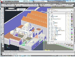
The extraction of textures (Figure 6) and the possibility of treating textures with specific softwares. When we extracted textures, we treated them with specific softwares of image editor to make orthophotos for texturing the 3D model (Figure 5) and (Figure 6).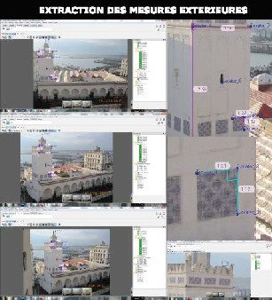
The photomodelling technic allow us also to recover some measurements information about ;
-the cracks appearing in walls after an earthquake, specifically when the construction is very weak or unstable.
-the additives constructions added over the existing houses and which are not accessible because of their illegal statement.
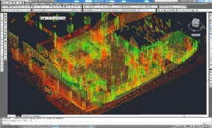
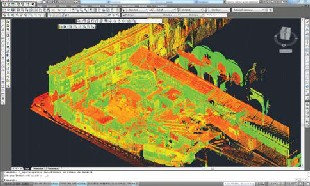
4.3 Step 3 ; the 3D laser measurement :
This part have been done with students of the ENSA of Paris La Villette with the laser Leica. This step was done outside and inside the building (Figure 8).
The steps followed were;
- First to put some target points to be able to recognize the differents angle of view of the cloud points,
- Second, to clamp and group the differents points cloud that were taken.
- Third, to erase the none relevant points
- Fourth, to construct the model by basing on the cloud point
- Five, add textures to the 3D model.
Than the more difficult parts concerns each view with some dropped parts.
IJSER © 2013
International Journal of Scientific & Engineering Research, Volume 4, Issue 10, October-2013 293
ISSN 2229-5518
In this paper we presented the differents steps used to restitute the mahkama of the great mosque of the Algiers city. This restitution have been done by student having an architecture diploma and are still in a progress formation to be specialised in heritage conservation management and the protection of the heritage architectural realizations of the EPAU LVAP laboratory.
This pedagogic environment was shared with student from ENSA of Paris La Villette for the 3D laser survey tool.
Than several tools have been used to restitute the building. Each tool allow student to recover a specific kind of measures. All these tools are complementary to have a complete and a global restitution.
Other restitutions of heritage building will be done in a pedagogic environment. These restitutions will be included in a database to constitute references for scientific or general people reaching about Algiers building heritage information.
[1] André Raymond, "Le Centre d'Alger en 1830," Revue de l'occident musulman et de la Meditérranée 31, no. 1 (1981):
73-74.
[2] Lespes René., 1930, Alger, étude de géographie et d’histoire
urbaines, Paris, Alcan .
[3] De Luca Livio, La photomodélisation architecturale, Relevé, modélisation, représentation d'édifices à partir de photographies, Eyrolles, Juin 2009.
[4] Missoum Sakina, Alger a l'epoque ottomane (xvieme-xixeme siecle): la medina et la maison traditionnelle, 2005, Edisud editions, 2005.
[5] Revue Africaine en ligne : http://www.algerie- ancienne.com/livres/Revue/revue.htm
[6] Chergui Samia, La « Nouvelle Mosquée » d’Alger. Le déroulement d’une procédure constructive aux viie siècle, Revue REMMN° 125, juillet 2009
[7] Chergui Samia, construire gérer et conserver les mosquées En El-Djazair Ottomane (XVIe-XIXe siècle), 2007, thèse de doctorat, La sorbonne, Paris.
Aknowledgements :
This work have been done thanks to some people persons of the Algerian ministry of Culture that allow us to access to the classified building. A special thanks to the post-graduated student of the LVAP laboratory in EPAU from the heritage option of the 2011-2012 year (Imène Arfi, Djamal-Eddine Grini, Badr El Mounir Horra, Sabrina Kasbadji, Yacine Kouri, Nacereddine. Makhloufi, Nabila Stambouli) and their teachers from the LVAP team; Mme Nabila Cherif, Mme Tsouria Kassab, Mr Boualem Djebri.
And also a special thanks to the student of l’ENSA de paris la Villette, students (Lena Charbonnier, Alexandre Cressey, Tahar Dargache, Dominique Delord, Khellaf Kherbache, Fabien Lepetit, John Ly, Bouchra Saadalah, Smail Sabete, Joscha Treeck, Isabelle Hydo, Joseph Dugan, Ma Kiaojun) and their teachers ; Mr Dalil Hamani, Mr Dominique Beautems, Mr Remy Huneau and their
IJSER © 2013