International Journal of Scientific & Engineering Research, Volume 4, Issue 6, June-2013
ISSN 2229-5518
Study of Flexible Pavement Distresses on a Section of GT Road, Pakistan.
Khan. K.M. 1, Riaz. K. 2, Ahmad. N. 3, Ahmed. I. 4, Ali. F. 5, Ahmed. S. 6
Abstract— Better and efficient Transportation system is a key to success for a developing nation. But it is affected by large number of causes and one of them is the distresses develop on the pavement during its service and result in premature failure of the pavements. There are numerous distresses found in the road. In this research paper the common distresses are discussed in the light of a survey conducted on a road. A section of GT Road from Taxila to Gujar khan (north N-5) is surveyed and the distresses found on it are also discussed and their probable causes and remedial measures are also provided.
Index Terms— Transportation System, Distresses, Pavement, causes, remedial measures
—————————— · ——————————
1104
1 INTRODUCTION
ransportation system is one of the most important factors affecting the national and public economy/development of any country. The better transportation system is the
necessity for developing the nation and public economically.
Pakistan is one of the developing countries and roads are used mainly for transportation. Unluckily the flexible pave-
ments in Pakistan undergo different types of distresses very soon after construction and the commuters suffer severely up- to the application of some remedial measures. A number of times, the remedies engaged do not serve properly due to er- roneous investigation of the distress cause and the funds/ efforts used are wasted, sometimes repeatedly.
So deep study of these distresses is very necessary to find out and classify these distresses, their genuine reasons/causes and then to know what theoretical and practical solu- tions/remedies can be adopted for effective healing of these distresses.
1.1. Scope of Research
GT Road from Taxila to Gujar Khan (Section of N-5) has been visited and found exhibiting variety of distresses. Said section has been selected as sample section and distresses available physically have been studied, listed and matched with theoretical information already collected.
Remedies have also been collected from literature and engineering departments and report has been composed.
2. LITERATURE REVIEW
Nejad F. M. et al presented an automatic diagnosis system for detecting and classification of pavement crack distress based on Wavelet–Radon Transform (WR) and Dynamic Neural Network (DNN) threshold selection. The algorithm of the
————————————————
1. Associate Professor, Civil Engineering Department, UET Taxila, Pakistan
Email: Kamran.mzaffar@uettaxila.edu.pk
2, 3, 6. Research Assistant, Civil Engineering Department, UET Taxila, Pakistan. Email: Engrkashif_89@yahoo.com
4. Lecturer, Civil Engineering Department, MUST (Mirpur) AK, Pakistan
Email: imtiaz674@gmail.com
5. Research Officer, Planning and Development, Pakistan
Email: faceuet@hotmail.com
proposed system consists of a combination of feature extrac- tion using WR and classification using the neural network technique. The proposed WR + DNN system performance is compared with static neural network (SNN). In test stage; proposed method was applied to the pavement images data- base to evaluate the system performance. The correct classifi- cation rate (CCR) of proposed system is over 99%. This re- search demonstrated that the WR + DNN method can be used efficiently for fast automatic pavement distress detection and classification. The details of the image processing technique and the characteristic of system are also described in this pa- per.
Brilakis I. et al presented a method for automated pothole de- tection in asphalt pavement images. In the proposed method an image is first segmented into defect and non-defect regions using histogram shape-based threshold. Based on the geomet- ric properties of a defect region the potential pothole shape is approximated utilizing morphological thinning and elliptic regression. Subsequently, the texture inside a potential defect shape is extracted and compared with the texture of the sur- rounding non-defect pavement in order to determine if the region of interest represents an actual pothole. This methodol- ogy has been implemented in a MATLAB prototype, trained and tested on 120 pavement images. The results show that this method can detect potholes in asphalt pavement images with reasonable accuracy.
A.Georgopoulos et al through their research paper described and proposed a method developed jointly by the Laboratories highway engineering and Photogrammetric of the National Technical University of Athens. The method involves digital image processing techniques to provide suitable digital image- ry as input to specialized software developed especially for this project. This software determines objectively and fully automatically the type, the extent and the severity of surface cracking for flexible road pavements. The proposed method presented substantial agreement, when compared with sys- tematic visual ratings of existing pavement cracking carried out according to the internationally accepted requirements for airfield and road pavement of the Federal Aviation Admin- istration (FAA).
Obaidat M. T. et al worked to investigate the potential of inte- gration of geographic information system (GIS), global posi- tioning system (GPS) and computer vision system (CVS) for the purpose of flexible pavement distresses classifications and maintenance priorities. The classification process included
IJSER © 2013 http://www.ijser.org
International Journal of Scientific & Engineering Research Volume 4, Issue 6, June -2013
ISSN 2229-5518
1105
distress type, distress severity level and options for repair. A system scheme that integrated the above-mentioned systems was developed. The system utilized the data collected by GPS and a PC-based vision system in a GIS environment. GIS Arcview software was used for the purpose of data display, query, manipulation and analysis.
Nejad F. M. et al focused on comparing the discriminating power of several multi-resolution texture analysis techniques using wavelet, ridgelet, and curvelet-based texture de- scriptors. The approach consists of four steps: Image collec- tion, segmentation of regions of interest (ROI), extraction of the most discriminative texture features, creation of a classifier that automatically identifies the pavement distress, and stor- age. Tests comparing the wavelet, ridgelet, and curvelet tex- ture features indicated that curvelet-based signatures outper- form all other multi-resolution techniques for pothole distress, yielding accuracy rates in the 97.9%.
Nejad F. M. et al proposed an expert system for pavement dis- tress classification. A radon neural network, based on wavelet transform expert system is used for increasing the effective- ness of the scale invariant feature extraction algorithm. Wave- let modulus is calculated and Radon transform is then applied to the wavelet modulus. The features and parameters of the peaks are finally used for training and testing the neural net- work. Experimental results demonstrate that the proposed expert system is an effective method for pavement distress classification. The test performances of this study show the advantages of proposed expert system: it is rapid, easy to op- erate, and have simple structure.
H.D Cheng introduced a new pavement distress image en- hancement algorithm, and a new analysis and classification algorithm. The enhancement algorithm corrects non-uniform background illumination by calculating multiplication factors that eliminate the background lighting variations. The new pavement distress classification algorithm builds a data struc- ture storing the geometry of the skeleton obtained from the threshold image. This data structure is pruned, simplified, and aligned, yielding a set of features for distress classification: number of distress objects, number of branch intersections, number of loops, relative sizes of branches in each direction, etc. This skeleton analysis algorithm relies on two-dimensional geometrical parameters, which are understandable by both developers and users, unlike some methods that deal with abstract quantities not readily understood by ordinary users. The proposed analysis algorithm can precisely quantify geo- metrical and topological parameters, can quickly accept new classification rules for classification, and can estimate the dis- tress severity from the threshold image.
3.ROADSIDE AREA FOR STUDY
3-1 Road stretch selected for study:
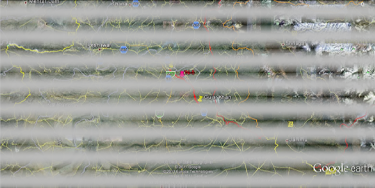
National Highway N-5 portion from Taxila to Gujar Khan has been selected, by this group, for studying the physical existence of different types of Flexible Pavement distresses. Said portion of GT Road consists of 70 Km between the chain- ages of Km 1493+000 and Km 1563+000. Location of the road stretch marked on Google Map is shown below in Fig. 1.
Fig. 1: Stretch of N-5, from Gujar Khan to Taxila, marked on Google Map
3-2 Climate of the selected section area:
The selected road portion passes through Rawalpindi and Islamabad which have a typical version of humid subtropical climate, with hot summers accompanied by a monsoon season followed by fairly cold winters. The hottest months are May and June, where average highs routinely exceed 38 °C (100.4 °F).The monsoon season is from June to September, with heavy rain falls and evening thunderstorms with the possibility of cloudburst. Winters are lasted from November to March with temperatures variable by location. In this area, temperatures vary from cold to mild, routinely dropping below zero. In the hills there is sparse snowfall. The weather ranges from a minimum of 3.9 °C (39.0 °F) in January to a maximum of 46.1 °C (115.0 °F) in June. The average low is 2 °C (35.6 °F) in January, while the average high is 40 °C (104.0 °F) in June. Climate charts/data of both the cities are given below
IJSER © 2013 http://www.ijser.org
International Journal of Scientific & Engineering Research Volume 4, Issue 6, June -2013
ISSN 2229-5518
1106
a) Climate data of Rawalpindi
Rawalpindi | ||||||||||||
J | F | M | A | M | J | J | A | S | O | N | D | |
56 17 3 | 65 19 6 | 80 24 11 | 36 30 17 | 31 41 32 | 60 46 26 | 258 36 28 | 287 34 27 | 91 34 24 | 27 31 17 | 14 24 9 | 34 19 5 | |
Average max. and min. temperatures in °C | ||||||||||||
Precipitation totals in mm | ||||||||||||
Source: World Meteorological Organization | ||||||||||||
![]()
b) Climate data of Islamabad
Climate data for Islamabad (1961–1990) | |||||||||||||
Month | Jan | Feb | Mar | Apr | May | Jun | Jul | Aug | Sep | Oct | Nov | Dec | Year |
Average high °C (°F) | 17.1 (62.8) | 19.1 (66.4) | 23.9 (75.0) | 30.1 (86.2) | 35.3 (95.5) | 35.0 (95.0) | 33.4 (92.1) | 33.5 (92.3) | 30.9 (87.6) | 25.4 (77.7) | 19.7 (67.5) | 28.5 | |
Average low °C (°F) | 2.6 (36.7) | 5.1 (41.2) | 9.9 (49.8) | 15.0 (59.0) | 19.7 (67.5) | 23.7 (74.7) | 24.3 (75.7) | 23.5 (74.3) | 20.6 (69.1) | 13.9 (57.0) | 7.5 (45.5) | 3.4 (38.1) | 14.1 |
Precipitation mm (inches) | 56.1 (2.2) | 73.5 (2.894) | 89.8 (3.535) | 61.8 (2.433) | 39.2 (1.543) | 62.2 (2.449) | 98.2 (3.866) | 29.3 (1.154) | 17.8 (0.701) | 37.3 (1.469) | 1,142.1 (44.965) | ||
Sunshine hours | 195.3 | 189.3 | 201.5 | 252.0 | 313.1 | 300.0 | 263.5 | 251.1 | 261.0 | 275.9 | 249.0 | 195.3 | 2,947.0 |
Source: HKO |
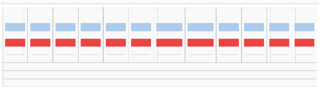
3-3 Geometry of road stretch
Geometric cross-section of the road has North Bound and
South Bound Carriageways. Each carriageway consists of standard size (3.65 m) two lanes with 1meter and 3 meter wide
inner s and outer shoulders respectively. Both the carriage- ways are separated by New Jersy Barrier (NJB) in urban areas and median in rural areas. Inner shoulder and two lanes have
2% cross slope and outer shoulder 4% cross slope. The road passes mostly through plain areas with zero or very small lon- gitudinal grade. At few locations in Rawalpindi City, there is
3-4 % longitudinal grade. Typical cross-sectional details are shown below
Fig 2. Typical Cross-section of the road
I
International Journal of Scientific & Engineering Research Volume 4, Issue 6, June -2013
ISSN 2229-5518
1107
The road has been constructed with both rigid and flexible pavement stretches at different locations. A linear plan show-
ing details regarding rigid/flexible stretches, location of medi- an/NJB, number of lanes, is given below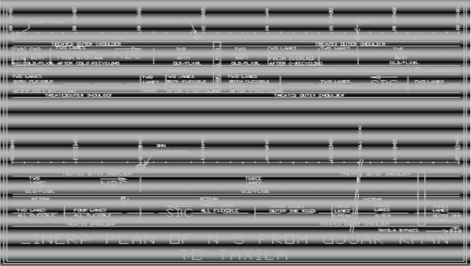
Fig 3. Linear Plan of the Road Section From Gujjar Khan to Taxila
3-4 Roadside population and traffic
The selected road portion passes through urban as well as
rural areas. Urban areas occurring along the selected road por- tion are Gujar Khan, Mandra, Rwat, Rawalpindi and Tarnoll.
In-between these urban areas are rural areas. Road is serving the fast moving vehicles i.e. motor cycles, cars, wagons etc. and slow moving vehicles i.e. tractor trollies, passenger bus- ses, trucks and heavy logistic trailers.
4. IDENTIFICATION OF DISTRESSES IN SELECTED ROAD STRETCHES
After literature review (Unit 2 above) and theoretical study
of flexible pavement distresses, the research team practically visited the GT Road (N-5) from Gujar Khan to Taxila Bypass. The road was found to be constructed in different stretches during different times. Some stretches, which are very old, are in very poor condition and have undergone a number of dis- tresses whereas some stretches, which have been constructed recently, are in very good condition and exhibit almost no damage. During visit only the flexible stretches were seen and the distresses were identified visually. The status of the dis- tresses observed is summarized in the table below
NBC Stretches where distress was observed
Sr. No. | Description of Distress | Stretch Chainage | |||
Sr. No. | Description of Distress | KM 1493-94 Both lanes KM 1517-20 Outer lane | KM 1494-96 Both lanes KM 1504-13 Both Lanes KM 1517-20 Inner Lane KM 1520-38 Both Lanes KM 1538-55 Three Lanes KM 1555-63 Both Lanes | KM 1496-1504 Both Lanes KM 1513-17 Both Lanes | |
1 | Fatigue (alligator) Cracking | - | √ | √ | |
2 | Bleeding | - | √ | √ | |
3 | Block cracking | - | √ | - |
IJSER © 2013 http://www.ijser.org
International Journal of Scientific & Engineering Research Volume 4, Issue 6, June -2013
ISSN 2229-5518
1108
4 | Corrugation and shov- ing | - | - | - |
5 | Depression | - | √ | - |
6 | Joint reflection crack- ing | - | √ | - |
7 | Lane/shoulder drop-off | - | √ | - |
8 | Longitudinal cracking | - | √ | - |
9 | Patching | - | √ | - |
10 | Polished aggregate | - | √ | - |
11 | Potholes | - | √ | - |
12 | Raveling | - | - | - |
13 | Rutting | - | √ | √ |
14 | Slippage cracking | - | √ | - |
15 | Stripping | - | √ | - |
16 | Transverse thermal cracking | - | √ | - |
17 | Water bleeding and pumping | - | - | - |
Comments | Rigid pavement stretches, not Observed for distresses. | Old Flexible Pavement stretches. The distresses marked are seen at numerous locations and in all severity levels. | Stretches fresh over- laid after cold recy- cling. The distresses marked are giving minor appearance. |
SBC Stretches where distress was observed
Sr. No. | Description of Distress | Stretch Chainage | ||
Sr. No. | Description of Distress | KM 1555-63 Outer one Lane KM 1553-55 Outer two Lane KM 1547-53 Outer one Lane KM 1514-24 Outer Lane KM 1503-05 Outer Lane | KM 1555-63 inner 2-lanes KM 1553-55 inner 1- Lane KM 1547-53 Inner 2-Lanes KM 1538-47 All 3- Lanes KM 1532-38 All 4- Lanes KM 1524-32 Both Lanes KM 1514-24 Inner 1-Lane KM 1503-05 Inner 1-Lane | KM 1505-14 Both Lanes KM 1493-1503 Both Lanes |
1 | Fatigue (alligator) Cracking | - | √ | √ |
2 | Bleeding | - | √ | √ |
3 | Block cracking | - | √ | - |
4 | Corrugation and shoving | - | - | - |
5 | Depression | - | √ | - |
6 | Joint reflection cracking | - | √ | - |
7 | Lane/shoulder drop-off | - | √ | - |
8 | Longitudinal cracking | - | √ | - |
9 | Patching | - | √ | - |
10 | Polished aggregate | - | √ | - |
11 | Potholes | - | √ | - |
12 | Raveling | - | - | - |
13 | Rutting | - | √ | √ |
14 | Slippage cracking | - | √ | - |
15 | stripping | - | √ | - |
16 | Transverse thermal cracking | - | √ | - |
17 | Water bleeding and pumping | - | - | - |
IJSER © 2013 http://www.ijser.org
International Journal of Scientific & Engineering Research Volume 4, Issue 6, June -2013
ISSN 2229-5518
1109
Comments | Rigid pavement stretches, not observed for distresses. | Old Flexible Pavement stretches. The distresses marked are seen at numerous locations and in all severity levels. | Stretches fresh overlaid after cold recycling. The distresses marked are giving minor ap- pearance. |
4.1. Distresses observed are visible on the road surface as shown by photographs below
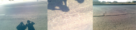
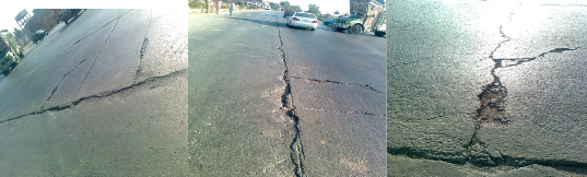
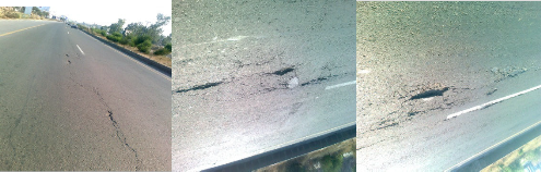
1) Fatigue (alligator) Cracking
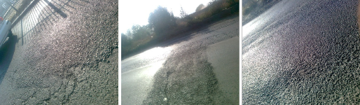
2) Bleeding
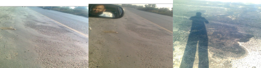
At KM 1525+000SBC at KM 1525+100SBC at KM 1533+000NBC
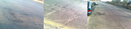
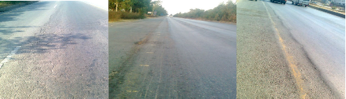
3) Block cracking
IJSER © 2013 http://www.ijser.org
International Journal of Scientific & Engineering Research Volume 4, Issue 6, June -2013
ISSN 2229-5518
1110
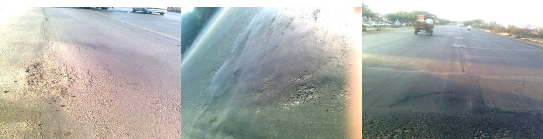
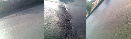
4) Depression
at KM 1537+000 SBC at KM 1548+200 NBC at KM1558+150 NBC
5) Joint reflection cracking
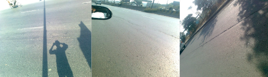
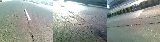
6) Longitudinal cracking
7) Patching
IJSER © 2013 http://www.ijser.org
International Journal of Scientific & Engineering Research Volume 4, Issue 6, June -2013
ISSN 2229-5518
1111
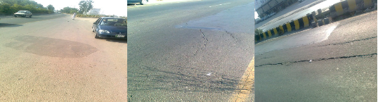
8) Polished aggregate
9) Potholes
Low severity pot holes Moderate and high severity Moderate and high severity
Pot-holes Pot-holes
at KM 1542+950NBC At KM 1533+125 SBC at KM 1533+219 SBC
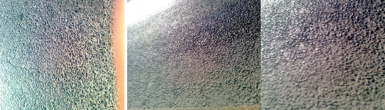
10) Raveling
IJSER © 2013 http://www.ijser.org
International Journal of Scientific & Engineering Research Volume 4, Issue 6, June -2013
ISSN 2229-5518
1112
11) Rutting
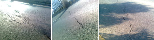
12) Slippage cracking
At KM 1557+150NBC at KM 1494+650 NBC at KM1504+100NBC
13) Stripping
At KM 1531+280 NBC at KM 1531+425NBC at KM KM 1543+175 NB
14) Transverse thermal cracking
Low severity thermal cracks High severity thermal cracks High severity thermal cracks
At KM at KM 1531+425NBC at KM 1524+800 SBC at KM1527+700NBC
IJSER © 2013 http://www.ijser.org
International Journal of Scientific & Engineering Research Volume 4, Issue 6, June -2013
ISSN 2229-5518
1113
5. CONCLUSIONS/COMMENTS
(1) The study was carried out by the Group in three steps. Each step after completion gives a group of similar infor- mation about the Flexible Pavement Distresses as below
In Step-1 the literature study for having information about Flexible Pavement Distresses detection and classification was carried out. A number of research papers were studied and some very useful proposals regarding distress detection and classification were collected and have been placed in Unit-2 of this report. In Step-2 different reports giving details of flexible pavement distresses commonly observed on roads were stud- ied. Seventeen number distresses, causes of their development and best possible remedies for their healing have been stud- ied.
In Step-3 a 70Km long stretch of GT Road (N-05, from Gujar Khan to Taxila Bypass) was visited by the team. The distresses studied were visually identified on the road. Photographs of these distresses, the road stretches exhibiting these distresses along-with road location, road geometry, climate of this area and linear plan of the road are shown in Unit-4.
(2) The analysis of the contents of Unit-4 leads to the results i) The distresses are common on old road stretches where
no proper drainage system has been provided and relatively less on well drained portions.
ii) The distresses are rare on recently constructed portions. iii) Rutting is common on truck lanes.
REFERENCES
[1] An Optimum Feature Extraction Method based on Wavelet–Radon Transform and Dynamic Neural Network for Pavement Distress Classification: Ferei- doon Moghadas Nejad, HamzehZakeri
[2] Pothole Detection in Asphalt Pavement Images:
Christian Koch, Ioannis Brilakis
[3] Digital Image Processing as a tool for Pavement Dis- tressess Evaluation: A.Georgopoulos, A. Loisos and
A.Flouda
[4] Integration of Geographic Information Systems and Computer-vision Systems for Pavement Distress Classification: Mohammed Taleb Obaidat, Sharaf A. Al-kheder
[5] A Comparison of Multi-resolution Methods for Detec- tion and Isolation of Pavement Distress: Fereidoon
Moghadas Nejad, Hamzeh Zakeri
[6] An Expert System based on Wavelet Transform and Radon Neural Network for Pavement Distress Classi- fication: Fereidoon Moghadas Nejad, Hamzeh Zakeri
[7] Automatic Pavement Distresses Detection System:
H.D Cheng ,M. Miyojim
IJSER © 2013 http://www.ijser.org