International Journal of Scientific & Engineering Research, Volume 4, Issue 12, December-2013 1817
ISSN 2229-5518
Structural Analysis of Existing Road Networks of
Assam: A Transport Geographical Appraisal
Bharati Gogoi
Abstract - Road has been described as the life-blood of human civilization. Social interaction and economic prosperity in space have been shaped by the road networks both at intra and inter regional levels. Consequently, it is regarded as one of the most important indices of economic, social and commercial progress of any region. According to IHDR (2011), the study area Assam ranked 16 (0.444) out of 23 states of India in human development indices in spite of its immense historical background, rich human resources and abundant mineral resources. The state does not have any remarkable industrial establishments with the population engaged in subsistence agriculture marked by low yield and productivity. An attempt has been made through the present study to explore the existing pattern and spatial variations of road networks of the study area with the help of structural measures of transportation network. Structural analysis of transport networks is getting utmost important in geographical studies because it involves the description of the disposition of nodes and their relationships and linkage of distribution. The study reveals that districts of Assam had minimum road density and most of the districts are characterized by minimum efficiency of road network in terms of connectivity. The efficiency of road network is very low and higher spatial imbalance.
Index Terms - Accessibility, connectivity, efficiency, economic prosperity, road network, social interaction, spatial variation
—————————— ——————————
1 INTRODUCTION
proper utilization of
IJSER
HE movement and exchange of people, goods and services is an obligatory feature of modern life
(Umoren et al., 2009) because of its multi-dimensional
functions and importance keeping relations and making
integrations among every aspect of a society ranging from an individual to a nation. Road that act as key for transportation of people and materials from one place to another have spread like veins and arteries throughout the country and brought substantial development (Badigar and Badigar, 2003). The improvement of transportation through road networks in between any two points leads to increasing regional specialisation reducing the transport costs. Agglomeration economies at not only the large cities but also in rural areas accelerate their growth, expand the markets and increase the dominance of transportation system. The impact of technological change in transport sector since the late 19th century has been as theatrical as in every sphere of life (Simon, 1996). While rebuilding any region or nation or country, roads always play a dynamic part. In essence, transport network is considered as a set of interconnected route linking with numerous destinations within and the outside the region and provides a pace for
————————————————
• Bharati Gogoi is currently pursuing Doctor of Philosophy in Geography in Dibrugarh University, India, PH-09859353977. E-mail: bharati_gogoi@rediffmail.com
movement of people and commodities. Practically, it performs manifold functions for the regional development reducing the spatial disparities and it brings equilibrium among societal, economic, political phenomena through the
resources. Transportation is not only a resource factor rather; it is a catalyst for the true development of various resource characters. No other transportation system is able to provide such a comprehensive door to door services nor any other mode have such extensive route network.
‘Transportation and Spatial Structure’ dealt with some
characteristics features of the processes in which the
transport networks are evolved (Taaffe and Gauthier, 1973).
These features play vital role in the development of a
region. In Assam, where other means of transport are yet to be developed, a well planned programme of the study of road network for its role in the development processes is urgently needed.
2 OBJECTIVES
1. To provide an idea about the existing road network of the district.
2. To find out the overall status of development of road network of the study area.
3. To find out the spatial variation of road network
development of the study area.
4. To suggest some relevant strategies for the policy makers.
3 DESCRIPTION OF STUDY AREA
Assam is a northeastern state of India. Its capital is Dispur, located within the municipal area of Guwahati city. Located south of the eastern Himalayas, Assam comprises the Brahmaputra and the Barak river valleys along with the
IJSER © 2013 http://www.ijser.org
International Journal of Scientific & Engineering Research, Volume 4, Issue 12, December-2013 1818
ISSN 2229-5518
Karbi Anglong and the North Cachar Hills with an area of
30,285 square miles (78,438 km²). Assam is surrounded by
six of the other Seven Sister States: Arunachal Pradesh,
Nagaland, Manipur, Mizoram, Tripura and Meghalaya.
Geographically Assam and these states are connected to the
rest of India via a narrow strip of land in West Bengal called the Siliguri Corridor or "Chicken's Neck". Assam shares international borders with Bhutan and Bangladesh.
Assam, extending from 89° 42′ E to 96° E longitude and 24°
8′ N to 28° 2′ N latitude. The total geographical area of
Assam is 78,438.08 km² with the total population of
31169272 persons including 15954927 males and 15214345
females in 2012 with a density of 397 persons per Sq. Km.
The total rural population is 26780516 and total urban
population is 4388756 in 2012. Assam comprises 27 districts,
56 sub – division, 219 Community Development Blocks, 184
circles, 214 towns, 26395 villages, 2202 gaon panchayat.
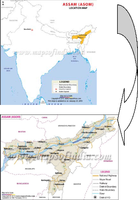
LOCATION MAP OF ASSAM
downpours reducing summer temperatures and affecting foggy nights and mornings in winters, frequent during the afternoons. Spring (Mar–Apr) and Autumn (Sept–Oct) are usually pleasant with moderate rainfall and temperature.
Comprising of valleys, hills and the perennial River of Brahmaputra, Assam Geography presents a fact file of the locational traits of the state. The forest lands occupy a major part of Assam's area. The agricultural fields of Assam are specially blessed by the River of Brahmaputra. Being divided into several rivulets and streams, the River as a whole makes the lands of Assam suitable for agricultural production. Adding the qualities of alluvial soil, Brahmaputra indirectly helps in increasing the crop growth of Assam state. The topography of Assam is also featured through many quaint hills that existed in the land from ancient periods. Placed on the foothills of the majestic Himalaya, Assam is adorned by beautiful valleys, rivers and plains. From Meghalaya, Nagaland and Mizoram to West Bengal, Arunachal Pradesh, Manipur and Bangladesh, the Assam area is a rich reserve of natural treasures. The area of Assam is known for its wide-spread tea plantation farms. Since the Assam topography comprises of various
geographical traits hence the place resembles the varied
IJSElandscapic chaRracteristics of the North Eastern Region.
With the “Tropical Monsoon Rainforest Climate”, Assam is temperate (summer max. at 95–100 °F or 35–38 °C and winter min. at 43–46 °F or 6–8 °C) and experiences heavy rainfall and high humidity. The average annual rainfall is
2296 mm. The climate is characterized by heavy monsoon
4 EXISTING ROAD NETWORKS OF THE STUDY AREA
After independence, the roads networks of the state have been extended a large. In 2012, the state had total 47448 km road length including 45500 Km. PWD roads and 1948 Km. National Highway. That accounts for approximately 60% of the total road length in the North-east. The major towns in the state are connected by National Highways. During the next five years, the Government will strive for the development of roads specifically in the industrial areas. Roads of the state have been maintained by different sectors of the Government like Public Works Department, Zilla Parisad, Gram Panchayet, Panchayet Samity and PMGSY. The total amount of road maintained by PWD is
45500 Km. Out of which 3134 Km. is State Highways, 4413
Km. is Major District road, 36544 Km. is Rural road and
remaining 1409 Km. is Urban road. The total surfaced
(Black topped) road network length is 21200 Km. and
Unsufaced road length is 24300 Km. On the other hand 4413
Km. road networks are maintained by Zilla Parisad. Gram
Panchayet and Panchayet Samity maintain surfaced road networks of 36544 Km. in the rural areas; while PMGSY bears the responsibility of habitation connectivity by connecting 7416 villages by surfaced road networks. The
roads of the study area can be classified in four categories i.e. National High way, State High way, District High way, Rural Roads and Urban Road.
IJSER © 2013 http://www.ijser.org
International Journal of Scientific & Engineering Research, Volume 4, Issue 12, December-2013 1819
ISSN 2229-5518
TABLE – 1
DISTRICTS COVERED BY NATIONAL HIGHWAYS
Source: Statistical Handbook of Assam, 2012
5 METHODOLOGY
Topological map of 27 districts of the study area Assam were prepared. 1,085 centres or nodes from 27 districts related to the structural analysis of existing road networks of Assam were identified on the basis of following characteristics-
1. Urban centres
2. Administrative head quarters
3. Regional and local market centres
4. Centres for education
5. Location point of health centres
To describe the road network quantitatively and to
SER
Baihata Chariali via Mangaldoi, Tezpur, Lakhimpur to Jonai
Silchar via Lakhimpur to
Imphal
Silchar to Aizawl
Kamrup, Darrang, Sonitpur, Lakhimpur and Dhemaji
Cachar
Cachar
compare the network of a district exactly with the other
networks of different districts following indicators have been analyzed.
TABLE – 3
FORMULA FOR STRUCTURAL ANALYSIS OF EXISTING ROAD
NETWORKS
TABLE – 2
DISTRICT WISE AND CATEGORY – W ISE LENGTH OF ROADS UNDER
PWD IN ASSAM, AS ON 31-03-2012 (IN KM.)


GTP =
(√𝑣− 1)2
6 RESULT AND DISCUSSION
Structural Analysis of Existing Road Networks of
Assam
Structure in transport geography refers to a system of arrangement consisting of a number of edges and vertices
IJSER © 2013 http://www.ijser.org
International Journal of Scientific & Engineering Research, Volume 4, Issue 12, December-2013 1820
ISSN 2229-5518
in a plain surface in terrestrial surface by making a nexus of spatial activities of people in order to get the connectivity.
6.1 Road Density
Density of road network indicates the length of road per unit of geographical area which discerns the degree of connectivity and accessibility of the road network system. The length of roads per lakh of population in Assam (2012) is 152.23 Km. The average density of the road network system per 00 Sq. Km. of geographical area in Assam is
60.49 Km / 00 Sq. Km. The state has been classified into three regions on the basis of road density. Thirteen districts namely Sonitpur (50.15), Lakhimpur (47.91), Dhemaji (41.40), Tinsukia (46.57), Dibrugarh (51.40), Karbi Anglong (41.29), Dima Hasao (38.38), Cachar (30.72), Karimganj (51.74), Hailakandi (35.64), Bongaigaon (46.66) Chirang (33.42) and Baksa (54.84) belong to the lower road density region. On the other hand, nine districts namely Kokrajhar (58.16), Dhubri (69.35), Barpeta (68.13), Marigaon (74.15), Nagaon (78.53), Jorhat (71.94), Golaghat (70.82),Kamrup Metro (72.87)and Darrang (57.60) belong to the moderate road density region while only five districts namely Goalpara (84.98), Sivasagar (107.72), Kamrup (92.86), Nalbari (95.59) and Udalguri (109.20) belong to high road density region (Table 4).
(1.25) have the most complex and well connected road networks. While nine districts namely Kokrajhar (1.14), Goalpara (1.14), Morigaon (1.125), Nagaon (1.20), Sonitpur (1.19), Tinsukia (1.17), Karbi Anglong (1.14) and Chirang (1.18) have moderate well connected road network and rest districts namely, Dhubri (1.06), Barpeta (1.08), Lakhimpur (1.09), Dhemaji (1.09), Dibrugarh (1.09), Karimganj (1), Hailakandi (1.05), Bongaigaon (1.06), Kamrup (1.07), Nalbari (1.06), Baksa (1), Darrang (1) and Udalguri (1.05) have the lowest well connected road network (Table – 5).
TABLE – 5
SUMMARY FOR BETA INDEX (Β)
Lower Value | 1 – 1.1 | Dhubri, Barpeta, Lakhimpur, Dhemaji, Dibrugarh, Karimganj, Hailakandi, Bongaigaon, Kamrup, Nalbari, Baksa, Darrang, Udalguri |
Moderate Value | 1.1 – 1.2 | Kokrajhar, Goalpara, Morigaon, Nagaon, Sonitpur, Tinsukia, Karbi Anglong, Chirang |
Higher Value | 1.2 – 1.3 | Sivasagar, Jorhat, Golaghat, Dima Hasao, Cachar and Kamrup Metro |
6.3 Alpha Index (ɑ)
The alpha index is a ratio measure of the number of the actual
IJSER
TABLE – 4
SUMMARY FOR ROAD DENSITY
Low Density | 30 – 55 | Sonitpur (50.15), Lakhimpur (47.91), Dhemaji (41.40), Tinsukia (46.57), Dibrugarh (51.40), Karbi Anglong (41.29), Dima Hasao (38.38), Cachar (30.72), Karimganj (51.74), Hailakandi (35.64), Bongaigaon (46.66) Chirang (33.42) and Baksa (54.84) |
Moderate Density | 55 – 80 | Kokrajhar (58.16), Dhubri (69.35), Barpeta (68.13), Marigaon (74.15), Nagaon (78.53), Jorhat (71.94), Golaghat (70.82),Kamrup Metro (72.87)and Darrang (57.60) |
High Density | 80 – 110 | Goalpara (84.98), Sivasagar (107.72), Kamrup (92.86), Nalbari (95.59) and Udalguri (109.20) |
6.2 Beta Index (β)
One of the simplest measures of connectivity is beta index (β) which can be found dividing the total number of arcs of a network by the total number of the nodes. Beta index ranges from 0.0 to network which consist just of nodes no arcs. If the value of beta index is greater than 1, the networks are well connected and higher values indicate higher the complexities of the networks. In the study area of Assam, out of 27 districts Karimganj, Baksa and Darrang have the lowest beta index value i.e. 1. On the other hand, Cachar district has the highest beta index value i.e. 1.297 enjoyed the most complex road network. The entire district has been divided into three regions on the basis of obtained beta values. In Assam, there are only five districts namely Sivasagar (1.25), Jorhat (1.295), Golaghat (
91.24), Dima Hasao (1.22), Cachar (1.30) and Kamrup Metro
circuits, to the maximum of in a given network. The range of
the index is from a value of 0 for a minimally connected
network to a value of 1 for a maximally connected one. The
district has been divided into four regions on the basis of
obtained alpha values. Tables 6 indicates that Karimganj,
Hailakandi, Bongaigaon , Baksa and Udalguri districts have minimally connected road network having the alpha index value 0. Eight districts namely, Dhubri (0.017), Barpeta (0.028), Marigaon (0.046), Lakhimpur (0.031), Dhemaji (0.031), Dibrugarh (0.037), Kamrup (0.023) and Nalbari (0.017) belong to the lower alpha index region having lower connected road network. While Kokrajhar (0.058), Goalpara (0.059), Nagaon (0.098), Sonitpur (0.089), Tinsukia (0.081), Karbi Anglong (0.062), Chirang (0.069) belong to the moderate alpha index region having moderate connected road network. On the other hand only five districts namely, Sivasagar (0.12), Jorhat (0.145), Golaghat (0.12), Dima Hasao (0.11) and Cachar (0.14) and Kamrup Metro (0.11) belong to comparatively higher connected road network.
TABLE – 6
SUMMARY OF ALPHA INDEX
IJSER © 2013 http://www.ijser.org
International Journal of Scientific & Engineering Research, Volume 4, Issue 12, December-2013 1821
ISSN 2229-5518
Value Golaghat (0.12), Dima Hasao (0.11), Cachar (0.14) and Kamrup Metro (0.11)

Since the number of faces is equivalent to the number of blocks, it is possible to judge that regions where the value of the alpha index is high have many blocks. This indicates that if the area of a region is fixed, the number of blocks is higher, and the average area of a block is smaller.
6.4 Gamma Index (ϒ)
Connectivity as measured by the Gamma index is expressed in terms of a graph theoretic range, that varies from a set of nodes having no interconnection of one centre to a set of nodes in which every node has an edge connecting it to every other node in the graph (Shing, 2003). The Gamma index is the ratio of the actual number of links to the maximum number of links that can be made according to the number of nodes on a graph. Simply Gamma index is a ratio between the observed number of edges and vertices of a given transportation network. The numerical range for the Gamma Index is between 0 and 1. Higher the value indicates higher the development of network. The Gamma index focuses on the connectivity of road networks. Tables 7 indicates that seven districts viz.
The difference between alpha and gamma indices is whether the focus is on the number of blocks or on the strength of connectivity of the road networks. As Okuno (1977) points out, while the alpha index does not accurately indicate the strength of connectivity of road networks, the gamma index overcomes this disadvantage.
6.5 Cyclomatic Number (µ)
Cyclomatic number is based upon the condition that as soon as a connected network has enough arcs or links to for a tree, then additional arcs will results in the formation of circuits. The cylomatic number 0 indicates a tree type graph, whereas the graph closer and closer to the completely connected state, the cyclomatic number increases. A disadvantage of this method is that networks with very different forms may have the same cyclomatic number (Waugh, 1995). Tables 8 indicates that the cylomatic number 0 of Karimganj, Hailakandi, Bongaigaon, Baksa, Darrang and Udalguri indicate a tree type graph while districts namely Sivasagar (17), Jorhat (20), Kamrup Metro (15) and Golaghat (15) having the highest cylomatic number represents its more closeness and more connected state of road network. On the other hand only six
districts namely Nagaon (13), Sonitpur (11), Tinsukia (9), Karbi
IJSER
Sivasagar (0.43), Jorhat (0.44), Golaghat (0.425), Dima Hasao
(0.425), Cachar (0.45), Chirang (0.44) and Kamrup Metro
(0.43) belong to the higher gamma index region. In the context of city planning, the road networks with a high value of the gamma index are well laid out in terms of the abundance of roads to choose from. Also, from the point of view of the possibility of a two-way escape, we can say that road networks with high value of the gamma index are well laid out. On the other hand ten districts namely Kokrajhar (0.41), Goalpara (0.40), Morigaon (0.41), Nagaon (0.41), Sonitpur (0.41), Tinsukia (0.40), Karb Anglong (0.39), Bongaigaon (0.40), Darrang (0.40) and Udalguri (0.39) belong to the moderate beta index region. Rest districts namely Dhubri (0.37), Barpeta (0.38), Lakhimpur (0.38), Dhemaji (0.38), Dibrugarh (0.38), Karimganj (0.36), Hailakandi (0.38), Kamrup (0.37), Nalbari (0.37) and Baksa (0.36) belong to lower gamma index region.
TABLE – 7
SUMMARY FOR GAMMA INDEX
Anglong (8), Dima Hasao (10) and Cachar (10) belong to the moderate cyclomatic index region having moderate value. Rest twelve districts namely Dhubri (1), Kokrajhar (3), Goalpara (4), Barpeta (2), Morigaon (2), Lakhimpur (2), Dhemaji (2), Dibrugarh (3), Chirang (2), Kamrup (2), Nalbari (1) have low value of cylomatic number and belong to the low cyclomatic number region.
TABLE – 8
SUMMARY OF CYCLOMATIC NUMBER
6.6 Grid Tree Pattern
The GTP index is derived by considering both typical types of road network patterns: the grid pattern and the tree pattern, and general road network patterns that are not classified as belonging in either the grid pattern or the tree pattern category. Thus the GTP index is considered as a new index combining the alpha and the gamma index. The GTP index is applied for evaluating road network patterns. The fact have to be consider that a square lattice pattern is considered to be an ideal pattern. The GTP is one of the most important measures
IJSER © 2013 http://www.ijser.org
International Journal of Scientific & Engineering Research, Volume 4, Issue 12, December-2013 1822
ISSN 2229-5518
for identifying pattern of network and connectivity. The value of GTP ranges from 0 to 1. The value of ‘0’ indicate that the existing network has tree pattern with poor connectivity & the value approaching towards ‘1’ represents grid pattern with highest network connectivity. The districts which have a GTP value of 0 are Karimganj, Hailakandi, Bongaigaon, Baksa, Darrang and Udalguri with tree pattern of road network and the poorest network connectivity. The poor connectivity of road network represented by hub and spoke pattern include the districts of Kokrajhar (0.16), Dhubri (0.1), Goalpara (0.16), Barpeta (0.1), Morigaon (0.13), Sonitpur (0.1), Lakhimpur (0.1),Dhemaji (0.1), Dibrugarh (0.12), Karbi Anglong (0.16), Kamrup (0.1), and Nalbari (0.1). Six districts namely Nagaon (0.24), Tinsukia (0.21), Golaghat (0.29), Dima Hasao (0.27) and Chirang (0.20) have hexagonal pattern which indicate moderate road network connectivity. The remaining three districts Sivasagar (0.30), Jorhat (0.36), Cachar (0.38) and Kamrup Metro (0.30) have grid pattern with highest connectivity of transport in Assam.
TABLE – 10
SUMMARY OF A. T. S.
Lowest Value | 1 – 8.1 | Kokrajhar (4.77), Dhubri (2.52), Goalpara (5.76), Barpeta (3.56), Morigaon (3.71), Lakhimpur (3.59), Dhemaji (3.59), Dibrugarh (4.61), Karimgnaj (1.37), Hailakandi (1.43), Bongaigaon (1.46), Chirang (3.89), Kamrup (3.5), Nalbari (2.50), Baksa (1.36), Darrang (1.4) and Udalguri (1.44) |
Moderate Value | 8.1 – 15.2 | Nagaon (14.98), Sonitpur (12.70), Tinsukia (10.86), Karbi Anglong (9.74), Dima Hasao (12.03) and Cachar (12.28) |
Higher Value | 15.2 – 22.3 | Sivasagar (19.10), Jorhat (22.24), Golaghat (17.07) and Kamrup Metro (16.98) |
TABLE– 11
DISTRICT WISE ROAD DENSITY AND COMPOSITE SCORE OF ROAD TRANSPORTATION IN ASSAM
TABLE – 9
SUMMARY OF GTP
IJ
Kokrajhar Dhubri Goalpara Barpeta Morigaon Nagaon Sonitpur Lakhimpur Dhemaji
1.14
1.06
1.14
1.08
1.12
1.2
1.19
1.09
1.09
6.7 A.T.S (Aggregate Transportation Score)
It is clear that thedistrcits namely Kokrajhar (4.77), Dhubri (2.50), Goalpara (5.76), Barpeta (3.56), Morigaon (3.71), Lakhimpur (3.59), Dhemaji (3.59), Dibrugarh (4.61), Karimgnaj (1.37), Hailakandi (1.43), Bongaigaon (1.46), Chirang (3.89), Kamrup (3.52), Kamrup Metro (6.97), Nalbari (2.50), Baksa (1.36), Darrang (1.4) and Udalguri (1.44) have almost equal and lower level of connectivity ranging from 1 to 8.10. Again, the districts like Nagaon (14.98), Sonitpur (12.70), Tinsukia (10.86), Karbi Anglong (9.74), Dima Hasao (12.03) and Cachar (12.28) have slightly better level of connectivity if compared with the previous category. Moreover, three distrcits i.e. Sivasagar (19.10), Jorhat (22.24), Golaghat (17.07) have higher A.T.S value which results higher degree of connectivity (Table
10). Therefore the overall picture of connectivity in the region
under study is more or less uniform with little regional
variations.
7 MAJOR FINDINGS
1. Assam has 40.49 Sq. Km road density per 100 Sq. Km. of geographical area, which is not satisfactory in position. Inter district variation of road density is very low.
IJSER © 2013 http://www.ijser.org
International Journal of Scientific & Engineering Research, Volume 4, Issue 12, December-2013 1823
ISSN 2229-5518
2. There is a little variation among the blocks in terms of Beta
Index and Gamma Index.
3. Three distrcits namely Goalpara, Kamrup, Nalbari and
Udalguri have minimally connected road networks in spite of
its higher density of road networks.
4. Karinganj, Hailakandi, Bongaigaon, Baksa, Darrang,
Udalguri have tree type of graph which represents the least
close road networks.
5. Inter distrcit variation of cyclomatic number is very high.
5. Cachar has higher close and connected state of road
networks in spite of its lower road density.
7. In case of all the connectivity indices (road density,beta,
alpha, gamma, cyclomatic number, GTP and ATS) only four
districts Golaghat, Sivasagar, Kamrup Metro and Jorhat represent highest value and highest degree of road connectivity and efficiency in the state.
8. Seventeen districts namely, Kokrajhar, Dhubri, Goalpara, Barpeta, Morigaon, Lakhimpur , Dhemaji, Dibrugarh, Karimgnaj, Hailakandi, Bongaigaon, Chirang, Kamrup, Nalbari, Baksa, Darrang and Udalguri have lower development of transportation in terms of connectivity and have the least efficient road network in Assam.
9. Karimgnaj, Hailakandi, Bongaigaon, Baksa, Darrang and
Udalguri have lowest development in terms of road
connectivity and efficiency in the state in spite of their strategic
aspects for proper utilisation of available resources. Not only the quantity but also the quality of the road network should be developed to achieve enough efficiency. Therefore, due attention should be paid by making required number of road to enhance mobility and efficiency in Assam, otherwise transport optimacy and its related development never be attained.
REFERENCES
[1] Badigar, G. S., K. R. Badigar, “Impact of Transportation Development on Industrialisation in Goa,” Geography of Transport development in India, B. C. Vaidya, eds. New Delhi: Concept Publication Company, pp. 250-272, 2003.
[2] C. H. Cooley, (1894). “The Theory of Transportation,” The American Economic
Association, http://www.jstor.org/stable/2485676. 2008
[3] P. S. Gautam, Transport Geography of India. New Delhi: Mittal Publication, pp.
1 – 6, 1992.
[4] B. W. Hodder, “Economic development reference to roads and road transport,” unpublished.
[5] B. Sukla, “Mass Transport Services in Calcutta Metropolitan Area,” Geography of Transport Development of India, B. C. Vaidya, eds. New Delhi: Concept Publication Company, pp. 124 – 139, 2003.
[6] H. M. Saxena, Transport Geography. New Delhi: Rawat Publication, pp. 9 –
35, 2010.
[8] P. Rogerson, Statistical Methods for Geography, A Student’s Guide. SAGE
location.
8 CONCLUSION
Publication Ltd: London, pp. 44 – 76, 2010.
[9] D. K. Halder, Studies in Urban Transport. Book Well Publishers: New Delhi, pp. 23 – 56, 2007.
[10] M. Yeats, An Introduction to Quantitative Analysis in Human Geography. Mc
The study reveals that in 2012, no districts of Assam had road density more than 150 km per 100 square km and most of the districts characterised by minimum efficiency of road network in terms of connectivity. Therefore, it is clear and evident from above discussion that the study area has been experiencing lack of spatial efficiency due to shortage road length. The consequence of which is very uneven spatial development when only a few parts of the study area is equated with well road network. As movements of people, goods and services are highly associated with efficiency of places, naturally the districts of the study area deprived of attaining this facility. Thus, nature of developmental efficiency is also poorer in the study area experiencing a large scale deprivation from every aspect of developmental issues in spite of its immense potentiality from different perspectives like forest resource, mineral resource, agriculture, tourism, agro based industries. These local facilities cannot be utilized properly without radical improvement of existing transportation (Cooley, 1894). Physical constraints like flood and monsoonal rainfall hinder transport development but at the same time it is also true that lack of transparency in between different Governmental organizations is another important factor for this. The progress of transportation is also necessarily dependent upon the consolidation of political power (Cooley, 1894). Number of roads in all blocks of the district should be increased to achieve the better connectivity and accessibility as improvement of transportation, including rural roads, is said to form the most valuable aspect of rural development (Hodder,; William,
1978). Efficiency of road network should be enriched in all
Graw Hill Publication: New York, pp 12 – 44, 1972.
IJSER © 2013 http://www.ijser.org