The research paper published by IJSER journal is about Scientific And Efficient Use Of Surface Water In The Basin Or Sub Basin 1
ISSN 2229-5518
The water resources in the country are limited considering the future demand. Moreover rainfall is confined to monsoon season and unevenly distributed both in space and time. At present various storages have been constructed to store water for various purposes. In case of heavy rainfall water gets spill over or in case of less rainfall there may be drought situation. Most of cases due to uneven rainfall in the basin or sub basin some storages/dams attain its maximum capacity, while some do not. On the other hand some basin has excess water available and some have deficit, while some basin/sub basin have exhausted the use of available water.
This paper represents the review of past work on the use of surface water by checking all possibilities like diversion of water from one basin/sub basin to other basin or sub basin, use of water by diverting it through available natural drain or local nallah from the catchment area of one reservoir to other, allowing spill water from dams to drains/river/local nallah by using existing canal system as a feeder canals etc.Attempts are also made to cover all methodology and techniques for water transfer in inter and intra basin.
Water is required in almost all activities of man, for drinking and municipal uses, for irrigation to meet production of food, power generation, for industrial use, navigation and recreation. It is most important part of development of country and hence it must be harnessed in most scientific and efficient manner. Based on the water availability India has divided in various basins. At present most of the basin have excess water available, while some have deficite.Verious dam or reservoir are constructed in the country. Because of uneven rainfall there are different problems of getting
reservoir full to its capacity. It often happens that
due to uneven rainfall in the catchment some reservoir get stored to its full capacity while some do not. In such situation even if water is available cannot be utilized to its full extent. Such situation can be studied and identify to divert the spill water to the river or natural drains. Such available water can divert or pump in adjoining river or nallah which can be optimally used. By making use of such water, it can be properly used in case of drought situation as well as new project can also be undertaken to increase irrigation, domestic and Industrial use. It will also defiantly useful to recharge the ground water levels in the area.
IJSER © 2012 http://www.ijser.org
The research paper published by IJSER journal is about Scientific And Efficient Use Of Surface Water In The Basin Or Sub Basin 2
ISSN 2229-5518
Luna Bharti, B.k.Anand, International water management Institute, Shrilanka consultant, Banglore, studied evaluation of water availability as against water demand in one of the NRPL link.i.e. From Godavari River (Poluvaram) to the Krishna River (at Vijayawada).The Godavari has been characterized as a surplus basin where as Krishna basin as a defecate one (GOI-1999) Based on annual water balance calculation as well as the current and projected (2025) water requirement, the central Water Commission (CWC) has concluded that the Godavari basin has sizable surplus water that can be transferred to water deficit Krishna basin.
Several link shave been proposed to transfer water from the Godavari to Krishna. The most downstream link-Palvaram (Godavari River)- Vijayawada (Krishna River) is considered to be a local project as an aim of this link is to transfer the water from Godavari to Krishna basin.
In order to assess the benefits of the proposed Polvaram project, two main scenarios were developed and simulated.
Scenario-1 Reference scenario: Water use under the current supply and demand network. The water source is ground water and river channel.
Scenario-2 with the polavaram reservoir and link canals water supply verses demand after the construction of Polvaram Project. The water source
is the Polvaram reservoir and link canal, Ground water and river channel.
After simulations with the link canal and reservoir show within the link command area, there minimal unmet demands for agriculture domestic and live stock requirements.
N.Ohara, A.M.SCCE, et.al. (2011),Detailed about significant increase in population in the Middle East has created new concerns about water needs for food production. Because water resources are very limited as a result of arid and semiarid climates of the region. Many Middle Eastern countries are highly sensitive to potential shortages in their water resourses.In the Tigris- Euphrates (TE) river basin, the largest water shade in the Middle East; the water resources have been intensively affected by the development of dams and barrages to store water for irrigation, hydroelectric power generation and general use by the region’s population. The author has pointed out that water regulation by dams in Turkey as well as these in Syria and Iraq, would eliminate critical water supplies from lower Euphrates and Tigris River that have sustained the ecosystem in the marshlands.
These remarks were largely based on static water balance studies (e.g.Kolars and Mitchell 1991) that used average river flow volume and irrigation water demands. Hence resulting water budgets used balances of the average water supplies and water demands during a historic period of record
or estimations of future irrigation water demands.
IJSER © 2012 http://www.ijser.org
The research paper published by IJSER journal is about Scientific And Efficient Use Of Surface Water In The Basin Or Sub Basin 3
ISSN 2229-5518
In this study, historic water demands-logic data
sets over the TE water shade climatic and hydrologic data sets over the TE water shade were reconstructed buy using a regional Hydro-Climate Model (Reg HCM-TE).Because the model is described in detail in the accompanying paper by chem. Et.al.(2011).In addition to climate and hydrological data sets, irrigation water demand under various water resource utilization scenario needs to be estimated (i.e. Irrigation activities are, by far, the most significant consumer of water resources in this water shade).Then corresponding to each utilization scenario the operation of the water resources system should be simulated to quantify dynamic water balances under the hydro climatic condition of the historical critical dry and wet periods. Within this frame work critical period analysis of available stremflows records in the TE water shade were performed to determine the historic critical dry and wet periods. Mean while irrigation water demands under various water resources utilization scenario were estimated by using vegetation pattern that corresponds to the historic critical dry and wet period. To compute the dynamical water balances within the water shade under utilization scenario, the computer model for operation of the system of reservoir within the water shade was used in this case study. Within this dynamic water balance-modeling frame work the effect of chronologically sequential water balances with daily temporal resolution over the whole TE water shade under various water resources utilization scenarios were quantified and
assessed.
Turkey has constructed 14 dam, five on Tigris and
nine on the Euphates.Syria has eight dams in the basin; the largest is the Tabqa Dam on Euphrates River. Iraq which lies downstream of the Turkey and Syria has 19 dams and barrages. Several reservoirs in Iraq are off-channel and make use of land depression where limited land gradient exists. Reservoir in Iraq is used for hydropower production, irrigation, and flood control and flow irrigation.
An objective of accurate assessment of water availability in the TE river basin under historically adverse water deficit and flood conditions is essential. The critical dry period is defined as the period with the list amount of water resources available in the historic record, where critical wt period is defined as the period with the largest water surplus on record. Such period represent the most extreme hydrologic conditions that have occurred in the basin. Because the water balance may be transferred from year to year, cumulative water resource need to be considered when critical dry and wet periods are determined.
As described earlier, past studies in the TE river basin has focused on static and annual water balance(Kolar and Miccell 1991).Such balance did not considered daily, monthly and seasonal fluctuations that can significantly affect water flow of its ability to meet demands in given year. To accurate evaluate a water resource to meet demand its operation during extreme hydrological condition at monthly or finer time increment
IJSER © 2012 http://www.ijser.org
The research paper published by IJSER journal is about Scientific And Efficient Use Of Surface Water In The Basin Or Sub Basin 4
ISSN 2229-5518
should be simulated. Such simulation is called as
dynamic water balance.
Daily dynamic water balance was computed under various utilization.Scenerio for the TE water shade and series of scenario were studied.
1) Demonstrate the model ability to accurately simulate observed water balance during historic critical hydrologic period under natural flow condition before the construction of major dam in TE
2) Assess dynamic water balance in the TE system under current levels of water resources development utilization in Syria and Iraq, while keeping pre-1970 condition in Turkey (Natural, unobstructed flows from Turkey and
3) Investigate various water utilization scenarios that meet the water resources demands of all countries in the basin .Dynamic water balances were obtained by using computer simulation models.
Primarily water balance is calculated on the basin of annual resolution, while it is observed that it is not suitable to calculate water balance to meet water demands because daily, monthly and seasonal fluctuation plays important role in actual allocation. In this study operation of the water resource system affected by seasonal variation in hydrology was simulated. Historic climate data required for such study were reconstructed by
using regional Hydro-climate Model. The satellite
driven data, such as elevation of water shade
characteristics.
The water balance model within Reg HCM-TE was calibrated under pre-1970 natural, unobstructed flow condition and was successfully validated by comparing it with observed flow during the entire study period at several river locations within water shade.
To develop optimum water management policies over the TE water shade that minimizes substantial reservoir evaporation losses while meeting current irrigation water demands, water balance in Iraq and Syria were quantified under various water releases from Turkish sector. The simulation result showed that it is possible to meet the current irrigation demand in Iraq and Syria.
According to simulation result, the highly efficient water allocation would be activated by arranging the release from the Euphrates sector of Turkey according to monthly reasonability of irrigation water demands in Syria and Iraq and by diverting water from Tigris to the Euphrates through Sammara Thakur Complex during the irrigation season.
On the basis of results under historical critical dry period /wet period hydro climate condition the following are the recommendations.
1) Store snow melt water at high elevation in cooler region of the water shade by using high capacity reservoir with low surface area to
IJSER © 2012 http://www.ijser.org
The research paper published by IJSER journal is about Scientific And Efficient Use Of Surface Water In The Basin Or Sub Basin 5
ISSN 2229-5518
store volume ratio to minimize evaporation
losses through the year, this saves the water.
2) To operate the Tigris and Euphrates river as an integrated water resources system by utilizing the Sammara-Thartar complex divert extra water from Tigris river to support irrigation needs along the lower Euphrates river sector .
To regulate water release from dam in the Tigris sector of the TE water shade downstream is seasonally varying pattern to optimize storage in the dam at the cool sector of the water shade with low evaporation rates to minimize water losses whole meeting irrigation demand in downstream nation.
Jayant Bandopadhyay, 2005, Expliained about heavy investment in engineering structures have opened the possibilities of withdrawing more and more water from natural sources like lakes, rivers, and the ground water aquifers. More than half of all accessible global freshwater runoff is currently withdrawn for human uses. The consequences is that drastic reductions have been taken place in amount of water remaining in stream causing degradation of aquatic ecosystem and affecting negatively the various services provided by ecosystem. The Nile in Egypt, the Ganges in South Asea, The Amu Darya and Syr Darya in Central asia, Yellow river in Chana, the Colorodo river in North America etc.are among the major watercourse whose flow have been
obstructed and diverted to such extent that for part
of the year, little or none of their freshwater flow
reaches the sea (Postal 2000).
Transfer of water from one river basin to another basin has been practiced as an exemplary engineering response for meeting the growing water requirement. One of the earliest example of interregional water transfer (IWT) is found in Egypt, where in the pharanic era, engineering efforts had been made to moderate the flow of river Nile, King Mina, a rules of Egypt in the first Dysteny, had constructed large number of canals and bridges to carry the Nile water to lower land
.Another example is of Japan, where river transfer
water from several years.
The some concept of engineering generated the proposal for South to North water transfer project in China. The Yangtze basin, well endowed with the water as well as other southern basins benefiting from the ample summer monsoon precipitations, contribute about 80 % of the total annual run-off in China. However, the water from these rivers is available to only 40 percent of the arable land. On the other hand ,the drier regions in the North and North East of the Chana,the Huang he (Yellow),the Huai he ,the Hai he basins and the North west inland region together have more than the half of the geographical area with 45 percent of the arable land and nearly 36 percent of the population.They,however,have direct access to only 12 percent of the water resources of the country(Gijja and Shaik,2004)
IJSER © 2012 http://www.ijser.org
The research paper published by IJSER journal is about Scientific And Efficient Use Of Surface Water In The Basin Or Sub Basin 6
ISSN 2229-5518
India occupies about 2.5% of the terrestrial surface
water and 72% of the geographical area of South Asia. When viewed in terms of precipitation per unit area of the land, country receiving 4% of total global precipitations seems to be well above global average. None the less, with over 17% of the world population living in the contry, its position in term of per capita water availability is seen to be quite difficult. Above 71% of the available water resources of India is localized in 36% of the geographical area of the country, primarily in the Ganges-Bramhaputra-Meghna basin and all the west flowing rivers from the Western Ghats.
Transfer of water from river basin with higher rainfall to the drier basin with objective of irrigation started to encourage policy makers to think on IWTS.In this line; Rao (1975) proposed three links of canals between Brahmaputra and Ganga, between Ganga and Cauvery, and between Narmada and parts of Rajasthan with the purpose of transferring water to the drier areas in southern and western India. Such proposal was not favored by CWC of India on various grounds including cost.
The main idea of transferring water from the Ganga-Bramhaputra river system to the less water endowed areas in southern and western parts of India by linking canals, nevertheless, remained alive in the minds of official in India’s Ministry of water resources and CWC.With the formation of National Water Development Agency (NWDA) in
1982, it got in circulation again. The NWDA was,
subsecuatly entrusted with the task of developing
plans for interbrain transfer of water to examine the possible storage site and interconnecting link in details.
After detail studies he proposed 30 links in the Himalayan and peninsular components which are now important part of the recent proposal for ILR in the country (TFILR 2003).The justification presented for ILR by TFILR (2003:22) is based on addressed three links of needs
1The paramount need for national self sufficiency in food and energy with sustainability.
2 The need for regional equity in regard to poverty alleviation and means of livelihood for the rural agricultural based population in low rainfall areas.
3 The need for promoting greater cooperation amongst the states in management of interstate river systems, thus avoiding water disputes, which have held up development or caused ill will amongst them.
Secured supply of the domestic water needs is a basic human right and should receive top priority in policy. For this, water may transfer across river basin at all costs. In term of quantity, the domestic requirements are small and transferring such quantities across basin will not be costly.
Nigam et al. (1997) had undertaken water availability studies in few water scares areas of India and their study made it clear that if the precipitation available within the concern water
IJSER © 2012 http://www.ijser.org
The research paper published by IJSER journal is about Scientific And Efficient Use Of Surface Water In The Basin Or Sub Basin 7
ISSN 2229-5518
shades or sub basins is harvested and conserved
properly, supply of domestic water needs would not pose serious problem in most of the parts of the country. For promoting domestic water security in dries area of India, local level water harvesting and conservation has been proven technology. It is a cheap and socially acceptable technological option even today when compared with large storage a long distance diversion facilities, which often carry high financial, social and ecological costs (WCD, 2000)
This article stressed that in hydrological science there is no differentiation of river basins as surplus or deficit. Through an analysis of whatever is available in the open, this article questions whether a)the IlR can control floods in high rainfall areas and provide water security in the water scarce area of India .b)India’s food self sufficiency depends on irrigation from the proposed ILR and c)a comprehensive knowledge based for the Himalayan component available. The official document is not found to be able to convincingly answer any of the above questions in the affirmative. We their conclude that unless the proposed ILR is discussed in all details with the stakeholders, the wisdom of going ahead with the proposal, in parts or as whole, will remain questionable.
Jean-Philippe et al. (2010) has carried out
multilevel analysis of the dynamic of irrigation and land use in the Nagarjun sager project (South India) in times of changing water availability (2000-2006) highlights that during low flow year, there is large scale adoption of rain fed or supplementary irrigation crops that have lower land productivity but higher water productivity and that a large fraction of land is followed.
Paper deals with
1. Main features of NJS multipurpose project
2. Changes in land use over period 2001-06
3. Fram level adjustment
4. Evaluation of economic impacts of variable water supply
5. Managerial adjustments by comparing water demand and water supply.
This multilevel analysis of the dynamics of irrigation and use in the NJS irrigation project during times of changing water availability (2000-
06), suggest that water supply shocks have
dramatic effects on farmer’s practices, cropping pattern and food production in large irrigated project in South-India.
Multitemporal remote sensing techniques and high resolution statistics, supported by micro level information on farmers practices, allowed mapping ‚hot spots‛, where land use and
cropping practices dramatically changed during a
IJSER © 2012 http://www.ijser.org
The research paper published by IJSER journal is about Scientific And Efficient Use Of Surface Water In The Basin Or Sub Basin 8
ISSN 2229-5518
water supply shocks(2002/2003) with the clear shift
from Paddy cultivation to follow,rainfed grain crops or supplementary irrigation cotton and Chillies.Cropping pattern changes lead to lower agricultural value produced at the regional level, to lower land productivity but in same time water productivity showing that same time to higher water productivity showing that farmer optimize the scarce production factors
Horigjian hou,et.al.(2011),Morphological adjustment in the river system due to urban development can be considered in term of changes in the channel C/S reach and network and basin. This paper deals with 1) examining the linkage between rapid urbanization and alteration of river network in Shenzhen, China and explaining the temporary change in relationship between both variables according to different extent of urbanization during the period 1980-2005 and
2) Analyzing the change in ecological services in the river ecosystem based on the measurement of ecological capital in the Guanlan River sub-basin (GLSB) of Shenzhen.
With the rapid urbanization, the river in cities have been totally altered from their natural states or even obliterated from the urban land scope. Using combination of remote sensing and GIS urban development and river network between 1980-2005 were analyzed .The percentage of urban land changed from 0.6% in 1980 to 8.9% in 1988 and
34.5% in 2005.The river network in Shenzhen
experienced a rapid loss characterized by an
increase in structural simplicity and restriction of
tributaries. The cumulative length of river is shorten, drainage density has been reduced, forest, bodies of water have been decreased due to urbanization.
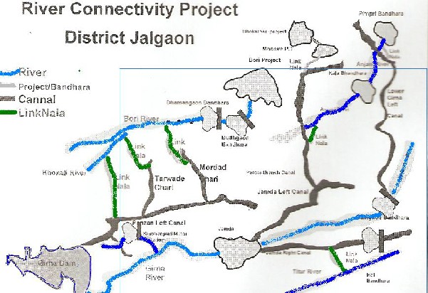
Demand based project through citizen’s participation, Jalgaon District is located in the North-West of the state of Maharastra.It receives the rainfall of about 690mm and temperature varies from 10-48 degrees Celsius. In July 2005, the district was unfortunate to receive scanty most of Maharashtra was experiencing flood like situations. The Jalgaon district has received less than average rainfall, i.e.only 15% by mid –July and 73% by end-October 2005, and too in unequal measures. Seven tehsil of Jalgaon district were in particular largely affected. There was no run-off water in the rivers and nalas; consequently, all water reservoirs were empty and groundwater levels was depleting while in the neighboring Nasik district, the Girna dam was overflowing. So this excess water from Girna dam, which was otherwise going waste, had the potential of being diverted to the water scares region of Jalgaon.
The diversion of surplus water from one region to the needy areas will avert the potential danger of floods and thus effectively harness the natural resources available. The objective of the project was ,providing water for drinking as well as irrigation purposes in the drought-bit areas of Jalgaon district by using diverted excess overflowing water, by adopting linking technique.
IJSER © 2012 http://www.ijser.org
The research paper published by IJSER journal is about Scientific And Efficient Use Of Surface Water In The Basin Or Sub Basin 9
ISSN 2229-5518
Since less than adequate rainfall in the seven
tassels was likely to create drought-like conditions. To overcome these problem and provide water for drinking purposes,useally in times of scarcity, new bore well are dug, temporary water supply schemes(TPWS) or existing water supply schemes are used or as a last mesuree,tanker deployed. But such an approach involves expenditure of crores of rupees every year. Moreover the expenditure does not create any permanent asset. The option of providing water tankers to tackle scarcity is not susstanable.The technique used to overcome the problem is based on innovative methods of linking of natural and artificial water drainage for inter- basin and intra-basin water transfer. This is unique technique of rain water conservation; utilization of flood water runoff and repleshing natural and artificial water bodies through natural and artificial water drainage channels.The excess water in a river is utilized to recharge the ground water bodies and dry wells in its command areas.The project is dedigned for the optimum utilization of rainfall-runoff for inter-basin and intra-basin water transfer through ennovative technologies of both
surface water transfer and grount water
recharge.The principal water shade management
within the command area is used not only for agricultural purpose,but also for drinking water and industrial purpose.
I.Linking of Bori and Girna river
The Girna major project is located on the border of the Nashik and Jalgaon districts.In 2005,due to heavy rains,in the interest of flood management,64000 cusecs water was released in the Girna river from the Tapi river,and finally into the arebian sea.
For regular irrigation purposes,the Girna project has Panzen left bank canal which flows towords Jalgaon district.The excess flood waters in the Panzan left bank canal were diverted and then the canal was breched at 31st km nad water was diverted into local nala,which flows and joins the Bori river by travelling a distance of 6km by gravity.The bory river flows 35 km towords the eastern side and reaches the Bori dam situated at Jalgaon district.This solevd the problem of water supply of Parola town and 73 villages depeded on Bori dam.
IJSER © 2012 http://www.ijser.org
The research paper published by IJSER journal is about Scientific And Efficient Use Of Surface Water In The Basin Or Sub Basin 10
ISSN 2229-5518
II Inter-linking of Girna and Anjani rivers.
The overflowing water was released in Girna river and the into Jamda weir.Jamda left canal and river to Parola branch canal and then water was released in Anjani river and Kala bandhara.The water traveled 127 km and problem of drinking water of Erandol and other villages were solved.
III Inter-linking of Girna and Titur rivers
The overflowing water after intering in Jamtha bandhara,diverted into the Jamtha right canal.From this canal,the water passed into a brook
and then successively into the Titur river.This
way,water traveled 84 km which solved the problem of drinking as wel as irrigation.
IV Filling of Bhokarbardi and Mhaswa project
The overflowing water was released from the Girna dam into the Girna river and then through Jamtha Bandhar,jamtha left bank canal which connected to the Paroala branch canal;tehn water reached to the Mhaswa dam.From here,water was channelized to the Bhokarbardi and Mhaswa Project.This solved the problem of drinking as well as irrigation.
V Filling of Pimpri Bandhara
IJSER © 2012 http://www.ijser.org
The research paper published by IJSER journal is about Scientific And Efficient Use Of Surface Water In The Basin Or Sub Basin 11
ISSN 2229-5518
The water from Girna dam to girna river then Jamtha bandhar and Dahigaon bandhar successively.From their water was passed into the Lower girna canal and then through the brook,this water was channelized and released into the Anjani river and then stored in Pimpri bandhar.In last stage ,the water traveled 186 km which was utilized for drinking and Irrigation successfully.
The benefits and after effect of Jalgaon River linking project have been validated through an independent socio-economic survey by third party agency.This survey was carried out in 2007-two year after the project’s implementation.The finding prove that the project is not only successful,but also susstanable;its benefits are still enjoyed by the peoples of Jalgaon.The project has been positively received by all sections of the society.
Conclusion;
1.Solved the problem of drinking for the population of about 8.5 lakhs.
2.Resulted in additional storage capacity of 4886
Mcft of water which is being used for irrigation.
Paper contributed to SADC RBO workshop on implementation of benefit sharing arrangement in SADC April-2010,Concept of benefit sharing (BS) is gaining popularity in transboundry water resources management and development. According to Sadoff and grey (2002), four types of benefits can be obtained from co-operation: I)
sustainable management of revering ecosystem
ii) Economic growth
iii) Political stability
IV) Regional integration.
First, cooperation can lead to better management of ecosystem, their by leading to ‘benefits to the river’ or ecological benefit. For example, wet lands, rehabilitation and restoration. Second, efficient cooperation in the management and development of transbondry river can yield major ‘benefit from river’ or development benefits such as increased food and energy production,i.e.direct economic benefit.Third,the easing of tension and building of confidance between riprapian states will result in a reduction of costs because of the river,as a tension between riprapian states will always be present,to a greater or lesser extent and those tensions will generate cost.Fourthly,co-operation will bring economic integration among riprapian state,generating ‘benefits beyond the river’.These benefits according to sadoff and Grey (2002) could be potentially obtained in all international river basin.
This paper uses the Lesotho Highlands water project(LHWP) in the Senque Orange River Basin,between the contries of Lesotho and South Africa as a case study to demonstrate how concept of BS can be aspplied in the transeboundry management and development of water resources.
The LHWP is one of the biggets international Inter
Basin Transfer in the world .Scheme transfers
IJSER © 2012 http://www.ijser.org
The research paper published by IJSER journal is about Scientific And Efficient Use Of Surface Water In The Basin Or Sub Basin 12
ISSN 2229-5518
water from highland of Lesotho through gravity to
water deficite Vaal region in SA.
The project considt of an interlinked system of dams and tunnels designed to regulate the flows of upper Senque (Orange0 river basin in Lesotho,to store awter in Lesotho and deliver it to the Vaal river absin in SA.The river system of the basin namely,Makhaleng and Mohokare and respective tributaries ,floew into SA,becoming the orange river.The South Africa could have impounded water from the orange river within its borders through the scheme known as Orange Vaal Transfer Scheme but water water is already too far south bt the time it passes from Lesotho to be easily accessible to the Vaal region.South Africa then found transporting water from the highlands of Lesotho through gravity as cheap alternative.
The water of phase –I is supplied by the following river:Malinbamatso,Senqu,Matsoku and Senqunyane .From Katse reservoir the water passes through the Muela hydropower plant to generate power.Afterword,the water is transferd by Trans-culeday tunnel into the upper reachs of the As river in SA.From tunnel outlet,the water flows northwaords via Saulspoort Dam,the Liebenber gsvlei river and the Wilge river to Vaal dam where water is impounded for industrial and municipal use in the Vaal river.
The project is managed by two countrie i.e.SA and
Lesotho an dbenefits are shared in ratio 44-
56,Lesotho share is paid by SA as a royalties over fifty year water delivary period.
The LHWP is a classic example that shows the
concept of BS can work.Given the Sandoff-Grey typology on benefits,the LHWP portraya classic direct economic type as co-operation between the two contries was necessitated by economic of social development needs.
The LHWC and the joint permanent technical committee (JPTC) between Botswana and SA served as a basis for the bigger basin management authority.In the orange Senque River Basin,the orange Senqu river basin commition (RASECOM).The two authority have been granted an authority to develop and implement policies and procensure of ORASECOM-Ad two bilateral agreement are not affected by the ORASECOM agreement according to its stipulation.
J.Nieto;D.N.Larner;A.J.Saul etc,Journal of Hydrology engg ASCE/Jan 2012,Explined abouth urban flood risk management. Hypothesis is that a simple water balance including rainfall inputs, surface storage and pathways is able to represent the main processes that are responsible for surface water flooding. Main objective are 1) to construct water balance model for urban surfaces2) to test its sensitivity and validity.
The model founded on a GIs approach that is widely accessible and capable of analyzing raster data: the most common format for digital Elevation Models(DEMs).GIS is also standard approach for special planning application and in this study ESRIGIS software was used to manage the data
and to assemble the surface water balance model.
IJSER © 2012 http://www.ijser.org
The research paper published by IJSER journal is about Scientific And Efficient Use Of Surface Water In The Basin Or Sub Basin 13
ISSN 2229-5518
Hydrodynamic model are those linked to a sewer
network may take several hours to simulate a large area .Such models are also complex often requiring an exact representation of the characteristics of the catchment surface and the input of large number of hydraulic and network parameters .These model require expert users. Hence, the development and application of a simpler and faster representation of surface water would be considerable benefit to all those involved in screening for urban flood risk management.
Researcher developed urban water balance model. Excess surface water is that which remains on the surface after accounting for losses. Such as infilteration.Water that drains to a surface sink is stored according to sink volume and any further water is passed downstream. In development of model land cover, runoff co-efficient, digital elevation model were studied.
Water balance is calculated by using standard ESRI Arc tool boxes and special analyst tools which are automated by using model builder and organized as tool boxes.
Result of models: 1) Sensitivity anlisis, the assumption mode in the model are tested with sensitivity analysis. It is performed for
1) The method used for processing multiple outlet sink
2) The criteria used to select sinks to be represented in the model.
3) The runoff coefficient values used to generate
the excess surface water.
Validation –The model is applied to four known catchments where flooding occurs. The runs by using 5, 10, 20, and 50mm rainfall depth. Were carried out and 10mm depth provided the closest match to known locations.
Conclusion-It is a simple method that can be used by decision maker to analyze effect and opportunities of development on surface water risks.
Rebecca L.Teasley,(2011) River basin management is as varied as each basin. Rapidly increasing populations and economic development in many basins often tightly constrain the allocation of limited water supplies. Water planning and operations in transboundry river basin that border or pass through two or more countries-can be difficult as it is based on politics, laws and regulations of the countries in those basin and possibly to co-operative agreements among the contries.The benefits of cooperatively managing transboundry river basins are often elusive and opaque to riparian shake holders sharing a basin. However the benefit can be increased through a co-operative allocation of the basins water.
The four riparian countries of the Syr Darya basin have existing water sharing agreement and have recently been negotiating a new agreement
(ADB2007)
IJSER © 2012 http://www.ijser.org
The research paper published by IJSER journal is about Scientific And Efficient Use Of Surface Water In The Basin Or Sub Basin 14
ISSN 2229-5518
In this paper benefits of cooperation to the Sry
Darya riparian countries from this new water and energy sharing agreement are analyzed by using co-operative game theory with a water resource model.
A river basin model is used to calculate the benefits of various operations for cooperation among the riparian contries.The model includes the two largest uses of Syr Darya water: Hydropower generation and irrigated agriculture.
The model allocates water for energy and agricultural production over a 10-year period by using a monthly time step and benefits were calculated to different contries.Model estimates the net benefits to the contries.Model estimates THE NET BENEFITS TO THE CONTRIES UNDER VERIOUS OPERATION COALIATION.The net benefits to each country calculated by model are used to determine the characteristic function for each possible coalition in the game theory analysis. The objectives of the countries are minimizing energy deficits and maximizing agricultural profits.
The Syr Darya Basin four riparian countries Kyrgyzstan (kg), Tajikistan (TJ), Uzbekistan (uz) NAD Kazakhstan (KZ) could form 15 coalitions or partnerships among themselves and benefits were calculated on the base of which, it was agreement: Kyrgyzstan may divert 0.5% of water, Tajikistan
7%, Uzbekistan 50.5% and remaining 42% is the
limit for Kazakhstan.
Limitation-Result is useful in relative sense rather
that in absolute sence.They indicates the difference between country position and satisfaction with various benefits allocation. This is attributable to several factors including sparse data concerning crop, prices, water use and return flows. These values can be updated to sharpen the result.
Conclusion-This paper analyze the draft agreement on allocation of water and energy resources of the Syr Darya Basin from the view point of benefits sharing and quantifies the benefits of co-operation among riparian nations to water resources in trance-boundary river basin. The analysis shows increased benefit to all counties in the basin if they follow cooperative arrangement outlined in the draft agreement.
From the above literature it can be concluded
1 Surface water can be used by Inter and Intra basin transfer.
2. Surface water can be used at reasonable cost as compared with cost of construction of reservoir by diverting or transferring in Inter or Intra basin through existing natural drains, rivers or existing canal system.
3. It is helpful for decesion maker to analyze the effect and opportunities of development on surface water.
4. Problem drinking water can be solved to some extent.
IJSER © 2012 http://www.ijser.org
The research paper published by IJSER journal is about Scientific And Efficient Use Of Surface Water In The Basin Or Sub Basin 15
ISSN 2229-5518
1 Prof Sanjay D Bonkile,Assistant Professor,Civil
Engg.Deptt.PRMIT & R Badnera,Amravati ,(MS)
e-mail: sanjay_db@rediffmail.com
2.Prof Dr P S Pajgade,Professor,Civil .Deptt,PRMIT
&R ,Badnera Amravati (MS)
References
1 Bandopadhyay, J. (2003) ‚and quit flows the
river project ‚The Hindu Business Line (Chennai)
14 March.
2 Luna Bharti, B.k.Anand, International water management Institute, Shrilanka consultant, Banglore,
3 Govt.of India ,Ministry of Water Resourses,1999.Integrited Water Resources Development-A plan for Action, Report of the National Commission for Integrated Water Resources Development,Vol -I,New Delhi, India
4N.Ohara,A.M.SCCE,M.L.Kavvas,F.ASCE;M.L.Ad erson,M.ASCE,Journal of hydrology engineering ASCE/Dec-2011/2071
5 Jayant Bandopadhyay, Breakthrough Vol II No 2
Sept 2005
6.Benefit sharing arrangements in the orange- senqu river basin: The case of Lesotho highlands water project (LHWP) Paper for SADC RBO workshop on implementation of benefit sharing arrangements in SADC April-2010
7 Linking Rivers in the Ganges-Brahmaputra River Basin: Exploring the Tran boundary Effects by Anik Bhaduri,International Water Management Institute, New Delhi and Edward Barbier
,University of Wyoming,Wyoming,USA
8 Strategic Analysis of the National River Linking Project (NRLP) of India Series 2,Procedings of the workshop on Analysis of Hydrological, Social and Ecological Issue of the NRLP
9Future Water Supply and Demand in the Okanagan Basin, British Columbia: A Scenario- Based Analysis of Multiple, Interacting Stressors, by Kirsten J.Harma.Mark S.Jonson.Stewart J.Cohen
,published online:03 Nov 2011 (Springer)
10 Interlinking of River Basins:A Mega Harvesting Plan-A Review By B.S.Prakasa Rao and Others in J.Ind.Geophy.Union (January 2010)Vol.14 No.1,pp
31-46
11 Interlinked modeling of large floods by combining one and two-dimentional diffusive wave approaches.4th International Symposium on Flood Defence:Managing flood risk,Reliability and vulnerability Totanto,Ontario,Canada.May 6-
8,2008
12 The Interlinking of Rivers:Some questions on the Scientfic,Economic and Environmental Dimensions of the proposal by Jayanta Bandopadhyay and Sharma Perveen,Paper presented at seminar on Interlinking Indian River:Bane or Boon? At IiSWBm,Kolkata 17 June
2003
IJSER © 2012 http://www.ijser.org
The research paper published by IJSER journal is about Scientific And Efficient Use Of Surface Water In The Basin Or Sub Basin 16
ISSN 2229-5518
13 Jean-Philippe Venot,Kiran Jella,Journal of
Irrigation and drainage engg ASCE/Sept-2010/595, (Jean-Phillipa Venot et al 2010)
14 National Water Development Feasibility Report of River Linking proposal for 14 Links and other information www.nwda.nic.in
15 Horigjian Zhou,PeinjuShi,Jing’ai Wang ,Journal
of Urban planning and development ASCE/June
2011/121,
16 West Bengal Academy of Science and Technology,Procedding of the workshop on interlinking of rivers,(May 23,2003),Kolkata 2004
17 River –Linking Plan to Have Big Impact on
Environment‛ Indian Express,Chandigarh,May
5,2003
18 J.Nieto;D.N.Larner;A.J.Saul etc,Journal of
Hydrology engg ASCE/Jan 2012,
19 IWRS (1996) Theme paper on Inter basin
transfer of water for National Development Problems and Perspectives Indian Water Resources Society.
20 MOWR (2002) Inter basin transfer planning for
Basin Transfer
21 Rebecca L.Teasley,Journal of Water Res
Planning and management ASCE Dt Dec/2011,
22 Jalgaon River Linking Project, Demand Based
Project Through Citizen Participation.
23 Samya Centre for Equity studies (3003),‛Linking of Indian Rivers: Some Concerns and Issues New Delhi :Uthra Print Communications.
IJSER © 2012 http://www.ijser.org