International Journal of Scientific & Engineering Research, Volume 4, Issue 7, July-2013 2330
ISSN 2229-5518
Preliminary Copper Ore Deposit
Investigation in Sabon Birni Area, Kebbe
Local Government Area of Sokoto State
1Kasim, S., 2Sabiu, B., 3Nura A. Yelwa
(sakasim@abu.edu.ng)
1Centre for Energy Research and Training, Ahmadu Bello University, Zaria-Nigeria
2Department of Chemical Engineering, Ahmadu Bello University, Zaria-Nigeria
3Department of Geology, Usmanu Danfodio University, Sokoto-Nigeria
ABSTRACT
This paper presents a summary and outcome of the field survey and field mapping carried out by the authors in and around Sabon Birni area of Kebbe Local Government area of Sokoto State Nigeria, with a view to finding out copper ore deposit concentration. The aim of the field study is to find out whether the copper ore deposit in Sokoto State is of commercial quantity and can scale through to exploitation stage. The work involves traversing the area, carrying out Chips sampling of the mineralized zone and alteration zone and also carrying out a field survey to gather initial geologic information. The result was accompanied with a simple mineral potential map and site plan of the area of interest. An attempt was made to express the probability of the presence of mineralization in each location, which is a very important step. The copper was seen in the original sample and verified and significant visible gold, related to this same mineralization, was also located at Sabon Birni. The samples obtained from the field were subjected to XRF analysis and the result show that copper ores has 64.30% copper oxide using standardless method.
KEY WORDS: Copper ore, Chip Sampling, Field mapping, Kebbe, Mineralized zone, XRF, Sokoto.
INTRODUCTION
Nigeria is endowed with a number of solid minerals and Sokoto State is not an exception. A mineral deposit is a mineral occurrence of sufficient size and grade that might, under the most favorable circumstances, be considered to have economic potential (Cox et. al, 1986). The
solid mineral industry in Sokoto is filled with
opportunities for interested investors to take position and make good returns on the investment. Sokoto is endowed with many natural and mineral resources. These include kaolin, gypsum, limestone, phosphate, feldspar, lignite, marble, clays, sand, gold, copper etc. The availability of these economic potentials provides good
investment opportunities for mining industries.
IJSER © 2013 http://www.ijser.org
International Journal of Scientific & Engineering Research, Volume 4, Issue 7, July-2013 2331
ISSN 2229-5518
Copper is one of the industrial minerals that have been discovered in Sokoto State. Copper (Cu) is a chemical element with atomic number 29. It is ductile metal with high thermal and electrical conductivity. It has many uses among which are: used in electrical wires, building material, industrial machinery, constituents of various metal alloys etc.
Not many research work have been conducted on
the exploration of copper ore deposit in Sokoto, it
is hope that this work will surely give interested companies chance to scale to an exploration and mining stage.
STUDY AREA
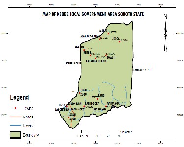
Kebbe Local Government area (Figure 1) is in Sokoto State, Nigeria. The local government shares border with Zamfara State to the east and Kebbi State to the west. It is about 150km away from the state capital. Although Sokoto is located within the Iullumeden basin, it is however surrounded to the east by the Precambrian basement complex (Figure
2).
Figure 1: Map of Kebbe Local Government Area
(Drawn by the authors)
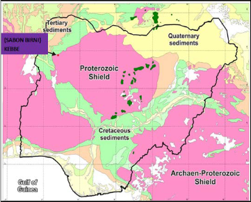
Figure 2: Map of Nigeria showing the study area
CLIMATE AND SOILS
The climate of Sokoto is tropical continental and is dominated by tropical and maritime continental air masses. In terms of climatic statistics, the annual
IJSER © 2013 http://www.ijser.org
International Journal of Scientific & Engineering Research, Volume 4, Issue 7, July-2013 2332
ISSN 2229-5518
rainfall for Sokoto ranges between 300 mm and 800
mm. The mean annual temperature is 34.5 0C, although dry season temperatures in the region often exceed 400C (Ekpoh and Ekpenyong, 2011). Sandy top soils and clayey subsoil are common; however, the study area is also rich in lateritic soil containing iron oxide.
DRAINAGE
Sokoto – Rima river system (Figure 3), which contains rich alluvial soil, is the most important river system that drains the area. Rivers Bunsuru and Gangare flow in a northerly direction, joining the Rima near Sabon Birni, the Sokoto, Zamfara and Ka tributaries.
GLOBAL TRENDS OF COPPER
The varying copper content of different types of ore deposit is inevitably reflected in differences in the average yields of ore mined in different countries and regions. Table 1 complements table shows the regional distribution of copper mine production, by continent from 1987 to 2008. It is presumed that the average percentage of copper content of ores mined has steadily declined.
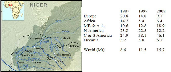
Table 1: Percentage shares of global copper mine output
Source: ICSG (2008), WBMS (2011)
METHODOLOGY
Figure 3: Drainage system showing two important rivers (Sokoto and Rima)
IJSER © 2013 http://www.ijser.org
International Journal of Scientific & Engineering Research, Volume 4, Issue 7, July-2013 2333
ISSN 2229-5518
The objectives of this work are to assess and evaluate the topographic map of Kebbe local Government area and delineate areas with high copper amplitude, conduct geological mapping of areas with high copper amplitude, collect rock, soils and stream sediment samples from high amplitude areas and analyse the samples for copper and/or any other mineral.
In the course of our field trip, the area traversed and covered is about 8km2. This areal coverage include not only that of copper deposits but also gold. Global Positioning system and Compass clinometers were used to locate positions and take directions respectively.
Chip sampling method of sample collection was adopted thereby making pieces of samples (ores) to be picked at random. The samples were collected from the prospect pits (dug by the local miners), underground workings and exposures of bedrocks where there is evidence of mineralization (Figure
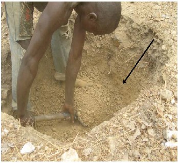
4). Local people were employed to dig some selected areas for overburden estimation (Figure 5). Alluvial and soil samples were collected across the
main target areas. Few stream sediments were also
collected along river channels where local miners
are mining gold locally (Figure 6).
Laboratory analysis of the samples was carried out at the Centre for Energy Research and Training, Ahmadu Bello University Zaria Nigeria using X- ray Fluorescence (XRF) machine. XRF is a non- destructive and reliable method and it requires no or very little, sample preparation and is suitable for solid, liquid and powdered samples (John et al.,
2001). The result of the XRF provides quantitative values of the oxides available in the ore deposits. PROCEDURE FOR THE ANALYSIS
The sample for analysis was weight and grinded in an agate mortar and a binder (PVC dissolved in toluene) was added to the sample, carefully mixed and pressed in hydraulic press into a pellet. The pellet was loaded in the sample chamber of the spectrometer and a voltage (30kv maximum) and a current (1mA maximum) was applied to produce the X-rays to excite the sample for a preset time (10 minutes in this case).
IJSER © 2013 http://www.ijser.org
International Journal of Scientific & Engineering Research, Volume 4, Issue 7, July-2013 2334
ISSN 2229-5518
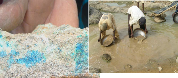
Figure 4: Sample containing copper (green) and
azurite (blue)
Figure 5: Determination of the overburden
Figure 6: Local miners in the stream collecting raw alluvial deposits containing gold as placer deposit.
RESULT AND DISCUSSION
The results of this work will be used to enhance the design for further exploration programmes both locally and regionally.
The initial geologic information gathered shows that the area is made up of two rock types. The rocks are metamorphic rocks i.e. phyllites and quartzite. Mineralization is found in both the rock types. A mineral potential map and site plan were prepared which give indication of the areas where
copper is concentrated and the actual coordinates
IJSER © 2013 http://www.ijser.org
International Journal of Scientific & Engineering Research, Volume 4, Issue 7, July-2013 2335
ISSN 2229-5518
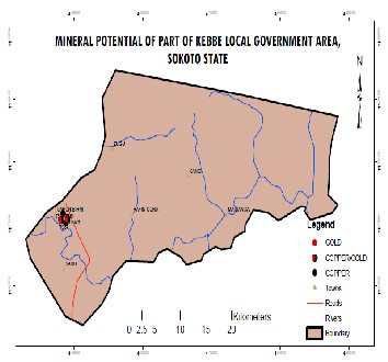
of the areas of mineralization (Figures 7 and 8). The depth to overburden which was determined based on the local pit dug during the course of this exercise ranges from about 4m to 6m from one place to another. However, accurate depth will be known when more holes are drilled especially with the help of drilling machines.
The grade will give us a quick and ready economic
assessment of the ore in question using the
available data. Ore grade is only possible when
proper geochemical analysis of the chipped samples is conducted. Although we could only ascertain the actual grade of the copper ore when detailed survey is carried out, it is however important to note that a simple geochemical analysis was carried out just to know the percentage of copper ore in the sample collected. This will give us an insight of the grade.
Figure 7: Map of Part of Kebbe local Government showing potential minerals
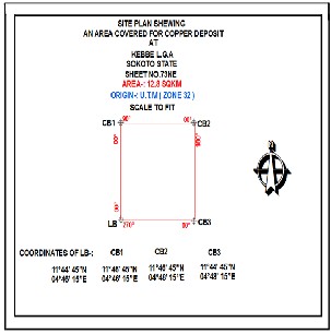
Figure 8: Site plan showing an area covered for copper ore deposit
The spectrum from the sample analysed and the concentration of the element in the sample using
XRF is given in the table below:
IJSER © 2013 http://www.ijser.org
International Journal of Scientific & Engineering Research, Volume 4, Issue 7, July-2013 2336
ISSN 2229-5518
Table 2: RESULT OF COPPER SAMPLE CARRIED OUT AT CENTRE FOR ENERGY RESEARCH AND
TRAINING, ABU ZARIA (concentration unit is in PERCENTAGE)
Application: Standardless
Time (s): 300
Initial Weight: 0.502
Final weight: 0.470
Al2 O 3 | SiO2 | P2 O5 | SO3 | K2 O | CaO | Sc2 O 3 | TiO2 | V2 O 5 | Cr2 O 3 |
7.1 | 20.7 | 0.1 | 1.1 | 0.819 | 0.32 | 0.01 | 0.628 | 0.070 | 0.045 |
MnO | Fe2 O3 | NiO | CuO | ZrO2 | Rh2 03 | BaO | Bi2 O3 |
0.020 | 3.33 | 0.13 | 64.30 | 0.03 | 0.02 | 0.16 | 1.1 |
The method can be used for wide range of elements and provide detection limits at the sub- ppm level; it can also measure concentrations of up to 100% easily and simultaneously (Jenkins, 1999). The major elements of the standardless reference of the characteristic X ray intensities as measured after the irradiation of the sample is presented. Eighteen elements were detected in all by the XRF method with varying concentrations. The result shows that cooper and SiO2 are the major constituents in the sample, however there are some aluminium and Iron oxide present. The result therefore indicates that the target mineral to be
explored is in abundance in the area.
CONCLUSION
In conclusion, it could be said that Sabon Birni area which is under Kebbe Local Government area of Sokoto State has proven to contain copper oxides. The standardless XRF method of analysis confirmed that the copper ore has 64.30% copper oxide. The copper exists as malachite. The mineralization is hosted in the Phyllite and Quartzite metamorphic association.
There is potential for additional gold mineralization in adjacent areas especially along stream channels where it exists as placer deposit.
RECOMMENDATIONS
IJSER © 2013 http://www.ijser.org
International Journal of Scientific & Engineering Research, Volume 4, Issue 7, July-2013 2337
ISSN 2229-5518
Special recommendations concerning next phases
of project are outlined below. We recommend that further work should be carried out on the area to ascertain the continuity and dimensions of mineralization. This shall include among others:
-Airborne geophysical survey and detailed geochemical mapping of the area be carried out to find out more of the solid minerals in Sokoto apart from copper.
-Geological mapping and prospecting of the field area.
-Remote sensing (satellite studies) and Geographic Information System (GIS) to determine local and regional structure, alteration and possible mineralization.
-Core drilling to delineate deep mineralization in the area.
ACKNOWLEDGEMENT
The authors are highly grateful to Ado Garba of Material Science Section, Centre for Energy Research and Training, ABU Zaria-Nigeria for his cooperation and assistance during the XRF analysis. We are also grateful to Abdullahi Lawal and Ibrahim Alti for their assistance during the
field trip.
REFERENCES
Cox, D.P., Barton, P.R., and Singer, D.A., (1986) Introduction, in Cox, D.P. and Singer, D.A., eds., Mineral deposit models: U.S. Geological Survey Bulletin 1693, p. 1-10.
Ekpoh, I. J. and Ekpenyong, N. (2011) The Effects
of Recent Climatic Variations on Water Yield in the Sokoto Region of Northern Nigeria, International Journal of Business and Social Scienc, Vol. 2, 7.
ICSG (2008) Statistics of the International Copper
Study Group, private communication.
Jenkins, R. (1999). X – Ray Fluorescence
Spectrometry. Wiley Interscience, New York. pp. 5-
7.
John A, Alexanda S, Larry A (2001). Approaching a universal sample preparation method for XRF analysis of powder materials. International center for Diffraction Data 2001, Advances in X – Ray Anal. 44: 368-370.
WBMS (2011) World Metal Statistics, Monthly
Bulletin, February 2011, Ware, Herts.
IJSER © 2013 http://www.ijser.org


