
International Journal of Scientific & Engineering Research, Volume 6, Issue 2, February-2015 612
ISSN 2229-5518
Planning Strategies for Traffic Management in Central Business District (Gandhi Square in Mysore City); an Urban Design Study
Development Studies, University of Mysore, Mysore, email id
Mysore, Mysore, amini.urbanplanner@gmail.com
—————————— ——————————
Pedestrian zone: Happy and healthy living in towns is related to the extent that town’s open green space system is enough
Transport is a functional land use. Transportation is an
essential part of today's life. It has been an essential and an integral part of the functioning of any city. Transportation plays an important role in the spatial organization of activities, exhibit the characteristics and determine its specific function and its importance for the overall development of the city. In the heritage urban areas, the well –organized transportation provides the connecting linkage with heritage landmark zone to avail the working opportunities and the movement of people in most efficient manner possible. The main factors which influence the choice of different modes of transport are cost of services, speed of transport, regularity and flexibility of services, traffic volume, and management. And density influenced the cost of service.
Transportation System Plan (TSP) that establishes a city’s goals in developing it’s transportation system for both in short and long run. The Plan identifies both existing and future needs, and recommends improvements to meet that needs. It must provide mobility and accessibility to all urban residents in a safe and environment friendly modes of transport.
Central Business District is focal point of a city. It is the commercial, office, retail, and cultural centre of the city and usually is the centre point for transportation networks.
Traffic congestion is a condition on road networks that occurs as use increases, and is characterized by slower speeds, longer trip times, and increased vehicular queuing.
for the requirements. Today, pedestrian zones have been
achieved to increase rapidly disappearing open space and to provide comfortable and safe circulation for pedestrians. A pedestrian zone is simply an area where vehicles are restricted and reserved for pedestrians who are free to occupy the entire space. The zone entrances and exits are often designated with signage to make all users of the road aware when they are entering or exiting such an area.
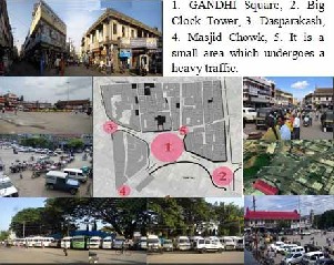
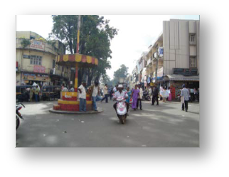
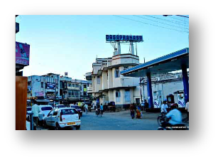
Gandhi Square: It is a heritage square which is situate in CBD area. It is a famous landmark which uses to be a plaza and cultural zone in last century.
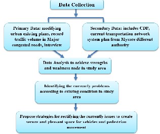
1. To analysis the existing land use and structural conditions of the buildings in the area.
2. To study the existing transportation system and traffic volume in the selected site.
3. To identify the problems in the CBD area.
4. To propose a planning design solution through creating pedestrian zone in the area.
The project has been deal with in five difference stages as follow:
IJSER © 2015 http://www.ijser.org
International Journal of Scientific & Engineering Research, Volume 6, Issue 2, February-2015 613
ISSN 2229-5518
![]()
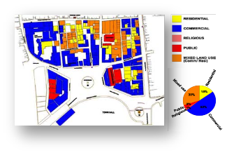
The existing land use constitutes mainly with commercial zone in 52%, especially around Gandhi square. Mixed land use is the second highest portion which includes commercial activity in ground and first floor, residential is the third one. The major business activities include Building materials, hardware’s, jewelleries, hotels, lodges etc.
In few places it is seen that the structural condition of the buildings are in dilapidated state needs to be demolished and redeveloped. The condition of buildings, the facade treatment, the alterations and transformations required to bring in the visual continuity and aesthetic ambience of the streetscape in influencing the visual perception and characters.
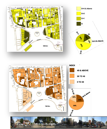
The Vertical developments with most of the buildings is as per the individual owner which do not satisfy the zoning regulations and planning parameters influencing the narrow streets and lanes in complicating the urban fabric without having the knowledge of the future. The max permissible FAR is 1.5 and the FAR consumed presently ranges from 3.5 & 4.
The developments tell us the past, present construction techniques and the materials used in different times expressing the Architectural characters in understanding the generations and the quality of life style in visualizing the transformation of urban space and the urban design of the future.
IJSER © 2015 http://www.ijser.org
International Journal of Scientific & Engineering Research, Volume 6, Issue 2, February-2015 614
ISSN 2229-5518
Non-existence of adequate and defined roads and footpath, the square area has been encroached by on street parking, which decreased its capacity. The urban infrastructures which are the urban characters like street lights, signage, furniture, drainages etc., are not well organized and have created visual chaos. Unauthorized street activity like street dwellers and hawkers on the pavements and roads causes disorder of municipal affairs. Movement pattern of pedestrian and vehicles has conflict which cause to urban distribution.
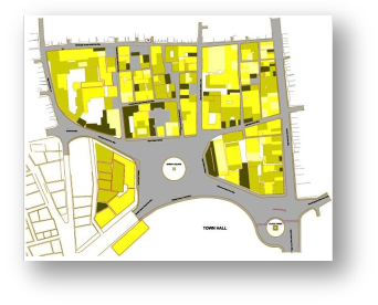
The amalgamation of the above maps (Condition of buildings/ building heights and land use) outlines to achieve synthesis map to determining issues and identifying required guidelines to propose best solution strategies. Darker nodes show spaces which have more opportunity for redevelopment.
IJSER © 2015 http://www.ijser.org
International Journal of Scientific & Engineering Research, Volume 6, Issue 2, February-2015 615
ISSN 2229-5518
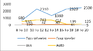
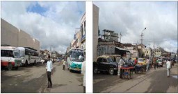
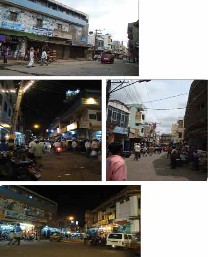
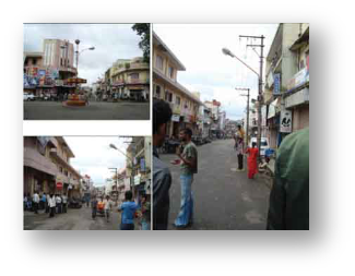
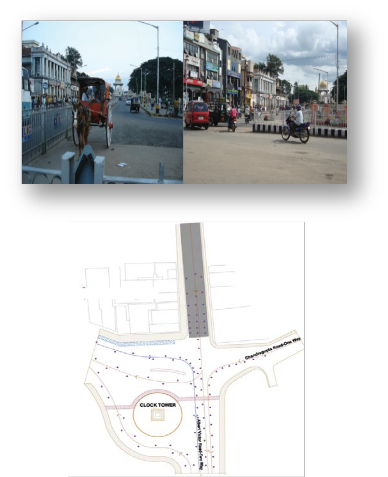
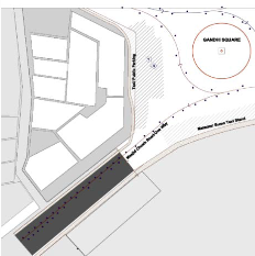 Figure 11: Soji Street views
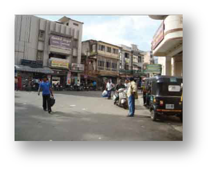
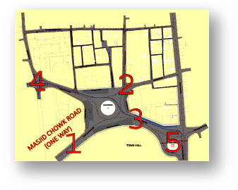
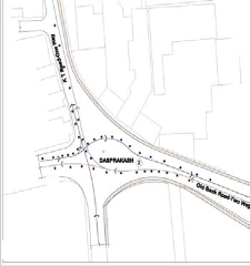
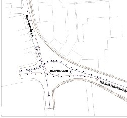
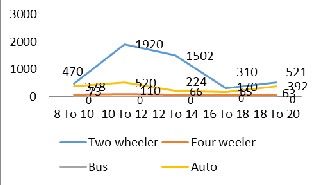 Table 4a. Traffic volume KT Street (One way) Figure10: Traffic volume in Masjid chowk road
IJSER © 2015 http://www.ijser.org
International Journal of Scientific & Engineering Research, Volume 6, Issue 2, February-2015 616
ISSN 2229-5518
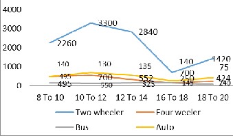
Time(hours) | Two Wh | Four wh | Bus | Auto |
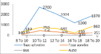
8 To 10 | 140 | 85 | 0 | 310 |
10 To 12 | 2700 | 450 | 0 | 750 |
12 To 14 | 2004 | 320 | 0 | 640 |
16 To 18 | 1200 | 130 | 0 | 230 |
18 To 20 | 1870 | 255 | 0 | 863 |
Total | 7914 | 1240 | 0 | 2793 |
IJSER © 2015 http://www.ijser.org
International Journal of Scientific & Engineering Research, Volume 6, Issue 2, February-2015 617
ISSN 2229-5518
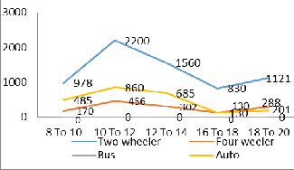
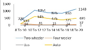
Time(hours) | Two Wh | Four wh | Bus | Auto |
8 To 10 | 978 | 170 | 0 | 485 |
10 To 12 | 2200 | 456 | 0 | 860 |
12 To 14 | 1560 | 302 | 0 | 685 |
16 To 18 | 830 | 130 | 0 | 130 |
18 To 20 | 1121 | 288 | 0 | 201 |
Total | 6698 | 1355 | 0 | 2361 |
IJSER © 2015 http://www.ijser.org
International Journal of Scientific & Engineering Research, Volume 6, Issue 2, February-2015 618
ISSN 2229-5518
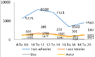
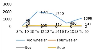
Time(hours) | Two Wh | Four wh | Bus | Auto |
8 To 10 | 5725 | 1289 | 301 | 1085 |
10 To 12 | 8100 | 1750 | 285 | 1417 |
12 To 14 | 7321 | 1560 | 293 | 1347 |
16 To 18 | 3500 | 950 | 301 | 723 |
18 To 20 | 4560 | 1202 | 180 | 1421 |
Total | 29206 | 6751 | 1360 | 5993 |
According to above traffic volume which mentioned the highest portion is belonging to two wheelers that are more in old bank road and Mahaveer road. The second highest portion is 4 wheeler and auto that according to width and accessibility of roads they changed alternatively. It is observed that peak hours for traffic volumes is 10 to 12 in the morning because offices start to work by 10.30 am in India and it is from 6 to 8 pm.
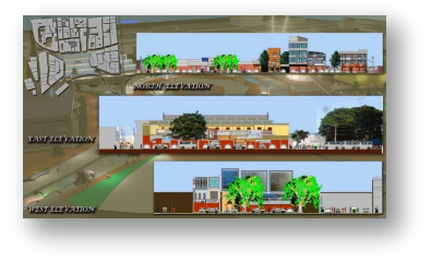
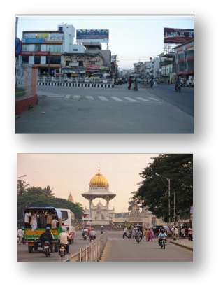
In this picture it is observed skyline of buildings around Gandhi square buildings materials and shapes is heterogeneous. Banners and boards of commercial stores don’t have any harmony in size and color which has bad effective on visual view. Existing of LMV in front of old amphitheater and around square provokes to existing chaos.
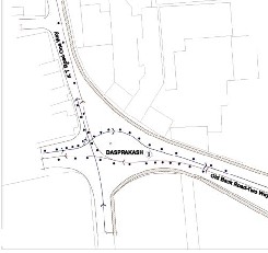
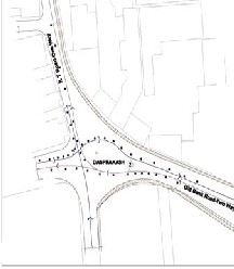
As specific in the master plan for preventing form conflict of pedestrian and vehicles movement, separate route for vehicles has been embedded. Plaza allocated in the center by number 3 which is a place for gathering people for festivals as past. In town hall yard some landscape design has done to create visual connectivity with pedestrian zone and plaza to
IJSER © 2015 http://www.ijser.org
International Journal of Scientific & Engineering Research, Volume 6, Issue 2, February-2015 619
ISSN 2229-5518
integrating precinct. One the edge of pedestrian zone there are spaces for vendors which would be able to have their activity in good order and in identified place.
In right side of square according to land use map in existing document there is an abandoned amphitheater which has been located by building number 5. This building has connected by Sky Bridge to town hall yard which prepare for people to have a bird view of site. In left side building number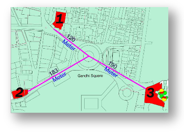
6 has been proposed to incorporate retail shops in one building. Around Gandhi Square there are three vacant lands which has shown by their distance in meter from center of study area under number 1, 2 and 3 which their area is 1024 m², 2000 m² and 3540 m² respectively. By considering their area location number 1 and number 2 is sufficient for multilevel parking for road users. Location number 3 because of its area and its accessibility to heritage zone like palace.
Big clock tower and other historical area would be a good nominate to propose cab service space for transferring local and international tourist.
Transport problems are very common in the Central Business District of Indian Cities as a result of the growing concentration of population, rapid urbanization and economic activities of certain point of the world. The problem associated with Parking and traffic Management problem within the Central Business District Area. Findings in this research work revealed that parking problems and Traffic Management which leads to time delays and traffic congestion are as a result of inadequate parking space, traffic signs/signals, human factor indiscipline act and development of illegal stalls.
All Local Planning Authorities should specify and enforced the provision of parking space in conjunction with new building in Gandhi Square, Mysore. It has been noticed that parking problems and traffic congestion are apparent in commercial area as a result of the land use pattern. The commercial land use has a high vehicular and pedestrian traffic generating capacity.
In light of the findings of this research work, the following recommendations are suggested to reduce and possible eradicate the problems of parking and traffic congestion confronting the study areas. Recommendation was made for Parking Management, Parking design standard, parking control; traffic management for both vehicular and pedestrian, Land-use and Land development; enforcement of edict and bye-laws by statutory agencies.
[1]. Raman, Afried (2003). Bangalore – Mysore. Bangalore: Orient Longman. ISBN 0-86311-431-8.
[2]. Schade, J., & Schlag, B. (eds.) (2003). Acceptability of transport pricing strategies. Oxford, Elsevier.
[3]. Kamath, Suryanath U. (2001).A concise history of Karnataka: from pre-historic times to the present. Bangalore: Jupiter books. OCLC 7796041. LCCN 809-
5179.
[4]. Khak Pour and Javaher Gholam (2014) Pedestrian Zone Planning in line with Sustainable Development with an Emphasis on Standards, Asian Journal of Research in Social Science and Humanties,Vol.4,No.3,pp.470-481.
[5]. Nasim Iranmanesh (2008), Pedestrianization a great necessity in urban designing to create a sustainable city in developing countries, 44th ISOCARP Congress.
[6]. Neil Davies (2010), pedestrian characteristics and control for the Toowoomba city center master plan area.
[7]. Kulash, Damian. (1973), Parking Taxes for Congestion Relief: A Survey of the San Francisco Experience. Report 1212-91. The Urban Institute, Washington, DC.
[8]. Balamohan (2000),Enterprise GIS Approach for Urban Transportation Planning, Travel Desire between municipalities and Doha, ESRI Map book Vol 14, Pp 109, ESRI, USA.
[9]. Sherman, R. (1972),Subsidies to Relieve Urban Traffic
Congestion‘, Journal of Transport economics and Policy,
6(1), pp. 22-31.
[10]. RegInald Souleyrette and Sitansu Pattnalk. (2003),Designing a traffic maintaining program using land use change detention. 6thAnnual conference and exhibition on GIS, GPS A.P and R.S January 28-31.
[11]. Bly, P.H., F.V. Webster and S. Pounds (1980), Effects of
Subsidies on Urban Public Transport, Transportation,
9(4), pp. 311-331.
IJSER © 2015 http://www.ijser.org
International Journal of Scientific & Engineering Research, Volume 6, Issue 2, February-2015 620
ISSN 2229-5518
1. Setareh Oruji, B. Architecture (Shiraz), M.A.,MUD(MYSORE)., PhD student in development study, Institute of Development Studies, University of Mysore, Mysore, Karnataka, India.
2. Dr. T. M. MAHESH, M.A.MURP, MUD (HONG KONG), Ph.D., Professor of Urban and Regional Planning, Institute of Development Studies, University of Mysore, Mysore, Karnataka, India.
3. EHSAN AMINI, B. Civil Engineering, M.A.MURP(Mysore), PhD student in Urban and Regional Planning, Institute of Development Studies, University of Mysore, Mysore, Karnataka, India.
IJSER © 2015 http://www.ijser.org