International Journal of Scientific & Engineering Research, Volume 2, Issue 11, November-2011 1
ISSN 2229-5518
Natural resource inventory of Manbazar block (Purulia district) in the eastern plateau of India: Technology intervention for sustainable agricultural development
Aditi Sarkar, P.K. Ghosal, B. Mahato and Pabitra Banik
Abstract— Natural resource base degradation, forest denudation, instability in crop production due to scarcity of water necessitates a thorough insight on sustainable agricultural development for conservation of natural resources not only for the present generation but also for the posterity. An attempt had been made to study the natural resource inventory of part of eastern plateau of India, using LISS III satellite imagery and Participatory Rural Appraisal Technique (procedure for rapid acquisition of sufficient knowledge with the involvement of rural people and household survey for development activity and decision making). Topo-sequence based micro-level
study revealed that there were four types of land situations: upper terraces locally called Tanr, Bahri (land close to homesteads), Baad (middle terraces) and Garha (lower terraces). Adverse biophysical and socioeconomic conditions and age-old, traditional, unscientific agricultural activities in the region act as deterrents for crop production and natural resource management. Based on the study, it can be concluded that priority should be given to long term strategies encompassing: construction of water harvesting structure of different sizes for different land situations; silviculture or silvi-pastoral system (cultivation of trees and pasture simultaneously) on upland; culti- vation of short duration flash flood tolerant high yielding rice variety for Aman (wet) season, and cold tolerant rice variety for winter season in low land areas; social forestry in degraded land; agro-ecologically suited cropping systems with suitable variety choice for problem areas; and judicious nutrient management in homestead gardens which may be ecologically suitable, socio-economically ac- ceptable, technologically sound, and environmentally sustainable for future perspective.
Index Terms— Manbazar block, natural resource inventory, Participatory Rural Appraisal, satellite image, spatial interpolation, water harvesting structure,.
—————————— ——————————
1. INTRODUCTION
he problem of water shortage in arid, semi-arid and sub- humid regions is one of low rainfall and uneven distribu-
tion throughout the season, which makes rainfed agriculture a risky enterprise. Therefore new interest came up in recent decades to evaluate traditional water management techniques (Prinz et.al. 1999) most of them being simple, sure to imple ment and of low capital investment. The classical sources of irrigation water are often at the break of overuse and therefore untapped sources of (irrigation) water have to be sought for increasing agricultural productivity and providing sustained economic base. Water harvesting for dry-land agriculture is a traditional water management technology to ease future water scarcity in many arid and semi-arid regions of world.
This old technology is gaining new popularity these days.
————————————————
Author: Aditi Sarkar is currently pursuing PhD programfrom Jadavpur
University, India, PH-+9830621995. E-mail:Aditi.iirs@gmail.com
Co-Author: Pabitra Banik is Associate Professor in Indian Statistical Insti- tute, India, PH-03325753226. E-mail: pbanik@isical.ac.in
As the appropriate choice of technique depends on the amount of rainfall and its distribution, land topography, soil type and soil depth and local socio-economic factors, these systems tend to be very site specific. The water harvesting methods applied strongly depend on local conditions and in- clude such widely differing practices as bunding, pitting, mi- cro-catchments water harvesting, flood water and ground wa- ter harvesting (Prinz 1996, Critchley and Siegert 1991). Micro- catchment water harvesting is a method of collecting surface runoff from a small catchment area and storing it in the root zone of an adjacent infiltration basin. The basin is planted with a tree, a bush or with annual crops.
The agricultural sector has an important role to play, both directly and indirectly, in the socio-economic growth and development of eastern India. The general scarcity of natural and agricultural resources mainly water, necessitates the im- plementation of sustainable agricultural management prac- tices (Mulder and Brent, 2006). Eastern India occupying a siz- able portion of cultivable land remains almost neglected. In most rural areas of eastern India, agriculture - often ‘subsis-
IJSER © 2011
http://www.ijser.org
International Journal of Scientific & Engineering Research, Volume 2, Issue 11, November-2011 2
ISSN 2229-5518
tence – oriented’ farming - is the primary source of their in- come. Household incomes depend on the natural resource base and agricultural conditions in the area make seasonal underemployment pandemic. Eastern plateau, a part of east- ern India is truly a representative of degraded soil with fragile ecosystem.
In much of eastern plateau the natural resource base can be characterized as poorly suited to agriculture because of climat- ic, water resource. Deforestation due to poaching of remaining forest areas and soil erosion due to erosive south-west Mon- soon rains (heavy flush of precipitation, which occurs during June to September) and unsustainable land use practices are proceeding rapidly in many parts of eastern India. Moreover, increase in population pressure per unit area, shrinking in arable land resources, soil degradation, depletion of nutrients from soil call for holistic approaches for sustainable develop- ment of natural resources to face the long march towards hu- man resource development. Under such perspective an at- tempt has been made to integrate modern technology and the farmers’ traditional wisdom. Trends with respect to the state of natural resources combined with the paucity of options for non-agricultural income make the prognosis for the future of the area and of the families that live there, worrying.
Ethnically, the eastern plateau lies in the so-called tribal belt
of eastern India. The population from scheduled tribe or sche- duled caste (Socio-economically backward and privileged group of people under Indian constitution Schedule Number
9/Article 244-244 A) families represents a large proportion of
the population. Individuals from tribal and scheduled castes represent around 40% of the total population in Purulia dis- trict.
The most effective way to develop the area is to develop the
agricultural systems as 90% of the inhabitants maintain their livelihood through agriculture and its allied enterprise and non-agricultural income generating source is also limiting for the study area. The agricultural system, which is now prac- ticed by the local inhabitant, is unsustainable without consi- dering the availability of natural resources. The sustainable agricultural system might be considered as the prime concern for developing the area where natural resource inventory will play a key role to support developmental planning and deci- sion-making and to provide a base line for technological inter- vention.
In order to target policies and develop appropriate technol-
ogies to assist poor farmers to improve their welfare while sustaining the natural resources upon which their long term livelihoods depend, it is important that policymakers, devel- opment agencies, and agricultural researchers have a realistic understanding of the existing natural and environmental con- ditions in areas where farming households live and work. In particular, it is essential that they have access to information about the biophysical constraints faced by farming households in their agricultural production and other income generating activities. This generalization is particularly true for rainfed lowland rice growing areas in Eastern India. In much of East-
ern India the biophysical environment is characterized as drought prone, heterogeneous in terms of micro-topography and accessibility, and suffering soil degradation as a result of years of deforestation and intensive agriculture.
With this background this study was undertaken to identify
the existing natural resources using image processing and GIS (Geographic Information System) tools and to study the agri- cultural scenario of the area to evolve site specific, need based, socially acceptable, eco-friendly technologies for sustainable agricultural development through natural water harvesting system.
2. MATERIALS AND METHODS
2.1 Data Used
Base map and Indian Remote Sensing (IRS) 1C Linear Imaging Self Scanning Sensor (LISS) III satellite imagery of Manbazar block of Purulia district were used for our study. It has four spectral bands: 0.52 – 0.59 m; 0.62 – 0.68 m; 0.77 – 0.89 m;
1.55 – 1.70 m with the resolution of 23 m. The swath was 141
km with 24 days of revisit cycle. We also used the resource
map made by the local key personnel using participatory rural appraisal technique (a qualitative investigation methodology
aims to involve a group of people in describing their shared situation and process of change in their own terms). Daily rainfall data collected from 263 weather stations covering the whole of West Bengal, Bihar and Jharkhand was also consi- dered for this work.
2.2 Software Used
Image processing and GIS software namely
i) GEOMETICA
ii) SURFER
iii) ARC VIEW
iv) IDRISI
The rainfall data collected from the 263 weather stations
were used to generate rainfall surfaces using spatial interpola-
tion technique (Krigging) in SURFER and IDRISI and these
raster surfaces along with potential evapotranspiration (PET)
data and soil water percolation rate and bund height for standing water in the field were used as inputs to generate
surfaces showing soil water storage at 23 and 44 Standard Me- teorological Week (SMW).
2.3 Natural resource inventory using satellite imagery
Resource mapping, such as mapping of the landuse pattern, soil physical characteristics, availability of surface water and crop characteristics was carried out by digital analysis of satel- lite imagery of Manbazaar I and Manbazaar II blocks of Pu- rulia district.
The digital data analyses were done using PCI Geo- matica software. Digital data processing techniques can be broadly divided into three groups.
Image rectification and restoration
IJSER © 2011
http://www.ijser.org
International Journal of Scientific & Engineering Research, Volume 2, Issue 11, November-2011 3
ISSN 2229-5518
Image enhancement
Image classification
The satellite imagery of IRS-1C LISS III dated Febru- ary 3, 2000 covering the study area was acquired from Na- tional Remote Sensing Agency Data Centre. The image was then registered with the topographical map (Toposheet) of Survey of India (SOI) through ground control point (GCPs) identification and by developing map to image coordinates transformation equation and the data was resampled for geo- metric correction. The boundaries of the blocks under consid- eration were also digitized from the SOI toposheets and over- laid on the imagery for the identification of the blocks. The blocks were then subsetted from the whole image. Supervised classification was performed using Maximum Likelihood Classification (MLC) algorithm for the following classes.
i. Forests (including homestead and perennial
vegetation)
ii. Degraded forests (including homestead and
perennial vegetation)
iii. Upper terrace (Tanr)
iv. Mid terrace (Bari & kanali)
v. Lower terrace (Garha)
vi. Stream channel (and lower terrace)
vii. Reservoir and Ponds
viii. Sand bank
ix. Township (Settlement)
Resource mapping was done with the help of participatory rural appraisal (PRA) technique and then digitized using GEOMATICA software. Local farmers drew a rough sketch of soil using wheat flour, turmeric powder, brick dust etc. and then the resource map was prepared on paper and digitized the same. Natural resource mapping was also done on IRS 1C LISS III imagery using GEOMATICA software.
2.4 Study Area
Our study area lies in the Manbazar I and Manbazar II blocks of Purulia district in the eastern plateau of India. The total geographical area of the plateau is 79270 sq. km., which is around 100% of the total geographical area of Jharkhand and
13% of West Bengal states.
of years of rice agriculture and tree cutting to meet household fuel needs. To support their livelihoods, farmers of Chotanag- pur area use a wide range of natural resources, including the rice plant and genetic resources, water, land and soil mineral nutrients. They also depend on weather elements, especially rainwater and solar radiation.
Under these circumstances, the main strategy is to help farmers effectively use and expand their windows of opportu- nity for rice production to meet their immediate household needs. So this paper attempts to explain and illustrate the nat- ural resources of the Manbazar block of Purulia district in the eastern plateau region in the context of rice production.
3. RESULTS AND DISCUSSIONS
Research over the past few decades by the agricultural re- searchers at large made significant achievements in boosting productivity. Achieving further improvements in agricultural production has become more challenging than ever before. This has to be accomplished using increasingly limited land, water, biological and other resources in the face of increasing population pressure and the mismanagement of natural re- sources may be the ‘Achilles heel’ of long term sustainable development (Kam, 2003). Recent trends are driving a demand of broadening research and management practices that are aimed not only at productivity gains but also at ensuring truly sustainable development in the ecological, economic and so- cial sense.
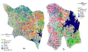
The landuse pattern of the study area (Fig. 1a & 1b) were analysed by unsupervised followed by supervised classi- fication of IRS 1C LISS III imagery using GEOMATICA soft- ware.
The elevation of the plateau is roughly 450 m above sea level. The climate of this region in general is characterized as sub- humid mega-thermal with a deficiency of water during the winter season. The variation of rainfall ranges from 810 mm to
2250 mm in a year. But the long-term analysis (50 to 70 years) of rainfall shows the annual average is 1230 mm. Rainfall is highly seasonal, 83% falling during the Monsoon season be- tween June and September. The land surface is rugged and has an undulating topography ranging from flat land to al- most steep slopes. Many areas in the Bihar Plateau suffer from soil degradation and degradation of forest resource as a result
IJSER © 2011
http://www.ijser.org
International Journal of Scientific & Engineering Research, Volume 2, Issue 11, November-2011 4
ISSN 2229-5518
Fig 1: Landuse pattern (a): Manbazar – I block, (b) Manba- zar – II block

Manbazar I Manbazar II

Forest 1427 (3.7) 958 (3.9) Degraded Forest 7751 (20.3) 4965 (20.46) Tanr (Upper terrace) 6915 (18.1) 3935 (16.22) Mid Terrace 9609 (25.2) 5671 (23.37) Lower Terrace 10416 (27.3) 4526 (18.65) Stream Channel 774 (2.0) 683 (2.81) Reservoir and Ponds 1059 (2.8) 2480 (10.22) Sand bank 241 (0.6) 39 (0.2) Total area (computed) 38192 24257
Total area (1991 Census) 38132 28581

Discrepancy (%) 0.2 15.12

Table 1: Landuse pattern (in hectare) of Manbazar I & Man- bazar II blocks of Purulia
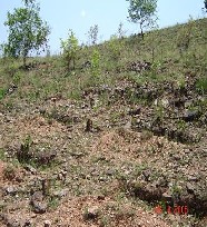
Results (Table 1) indicated that the discrepancies between the computed data and the data (block area) available in Census report was negligible for Manbazar I block (0.2%) but in case of Manbazar II block (15.12%) the discrepancy was quite high. This might be due to non-incorporation of some area within the block boundary as imposed on the satellite imagery. Data also revealed that the area under forest was very less (3.7% and 3.9% for Manbazar I and Manbazar II blocks respectively) whereas degraded forest area was reasonably high (20.3% and
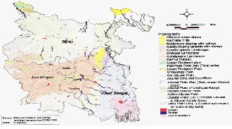
20.46% for Manbazar I and Manbazar II blocks respectively). Concerning the topo-sequence of the study area it was found that 17.16% of the total geographical area was under tanr (Up- per terrace) lands whereas areas under medium and low lands were 24.28% and 22.97% respectively. On scaling down to vil- lage, similar trend in landuse pattern was observed. This lan- duse pattern map along with the physiographic map (Fig. 2) and topographic map (Fig. 3) gave an insight about the natural resources of this area.
Fig 2: Physiographic Map of Bihar, Jharkhand and West
Bengal
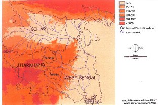
Fig 3: Topographic Map of Bihar, Jharkhand and West
Bengal
The girded surfaces for the average weekly field wa- ter storage for the weeks 23 and 44 (Fig. 4a and 4b) showed that the water storage was minimum in the region covering the Purulia district. Though there was slight increase in the field water in week 23, it declined in the week 44.
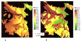
Fig 4: Average field water storage (a) Week 23, (b) Week 44
So, under such a water stress condition, certain technologies can be introduced depending on the various land situations. The main intervention for the degraded upland should be to replace rice by any short duration hardy non-rice crop and to check further land degradation through effective reforestation using appropriate and relevant tree species that can also pro- vide products for use of local residents. In case of water stressed soil condition of the cultivable mid - uplands, tradi- tional low yielding rice varieties should be replaced by high yielding non-rice crops that have low water requirement. Con- struction of water harvesting structures can be recommended for storing rainwater for irrigating the medium lands, which
IJSER © 2011
http://www.ijser.org
International Journal of Scientific & Engineering Research, Volume 2, Issue 11, November-2011 5
ISSN 2229-5518
provide the highest potential for supporting a variety of crops including rice. The most important intervention in the lowland is to improve short duration flash flood tolerant high yielding rice variety for wet season and cold tolerant high yielding rice variety for winter season. The detail technologies for the dif- ferent land situation are as hereunder.
3.1. Technology intervention on different land situation
3.1.1. Hillock Treatment-Staggered Trench
In practice, trenches of 6'2'1.5' are excavated with 6' spacing between trenches on the same contour and between contour lines (Fig. 5). The catchment area of the trench is (6'2'6'2') 6' 96 square feet. Assuming 2 inches of peak
rainfall, the water harvested from this area is 96 2 12 16
cubic feet. This water is to be entirely harvested in the lower
plot dimensions.
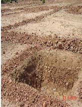
Fig 6: Pit made on upland with less than 8% slope
trench. The volume of each trench is kept as
6'2'1.5' 18
cubic feet so as to provide some free board in every trench.
The plots are planted with trees, shrubs, grasses, pulses, oil- seeds, vegetables and rice; either singly or in combination ac- cording to the local conditions. Trees are planted at a distance of 8 feet within the plots and bunds. Sabai is planted on field bunds and shoulder bunds (of the pit) in 2 feet apart, 5 slips to a pit.
3.1.3. Medium land (5% Model)
The pit is made in each and every plot and is to conserve moisture of 2 inches, which is the crop water requirement for two week. The average bund length per hectare is 3000 feet, the width being 2 feet i.e. the area under bunds per hectare is
6000 square feet. Since a hectare is 107640 square feet, the area
not under bund is 107640 6000 101640
square feet per
Fig 5: Hillock treatment – staggered trench
The treated area is put under trees and grasses, with one sapl- ing on every trench burn and the area between trenches under grasses. The number of trees per hectare will be 1122 (as many as the number of trenches). The area between two correspond-
hectare. Five percent of this area will be excavated up to a depth of 3.5 feet, in separate plots. The total earthwork there- fore is, 101640 0.05 3.5 17787 cubic feet.
3.1.4. Home-stead land
This is an age-old food production system practiced by village people in their backyard, with the help of limited to a short period of rain. It is located near or around home. It is mainly
ing pits on consecutive contours is 6'2'6' 6' 84
square
used for own purpose and based on local inputs. In homestead
feet. Sabai are planted in pits spaced 2 feet apart, 5 slips to a pit, the number of slips per hectare is 94185 4 5 117731
slips.
3.1.2. Upland
Upland treatment is done on slopes of less than 8%. The pit has to be designed to store a volume of 100 cubic feet of water.
HAPA use of wastewater, kitchen waste and animal manure is maximized and use of external inputs is very limited or un- common.
Pit dimensions of
6'6'3'
are normally used. In the actual
3.1.5. Dug-well
implementation, plots of 30'40' are first laid out, 30' along the
Another complementary device is the sunken or recharge well.
slope and 40' across the slope. A pit of
6'6'3'
is dug at the
These are man-made cavities or large diameter seepage wells.
lowermost corner of each plot (Fig. 6). The length and breadth are average dimensions. As the earth is very hard, vertical cutting of the earth is difficult. The section of the pit will there- fore not be rectangular but trapezoidal. The excavated earth is used to prepare bunds of 1' breadth and 9'' height along the
They receive water through capillary movement, seepage and percolation, which is stored in the well and in the recharge zone around the well. Surface water is safely stored as sub- surface water, which is available for use in dry winter and summer months. This water has better quality because of per- colation through soil layers. These wells are basically water
IJSER © 2011
http://www.ijser.org
International Journal of Scientific & Engineering Research, Volume 2, Issue 11, November-2011 6
ISSN 2229-5518
resource development devices and they should be left alone as such. They are not used to directly exploit ground water.
4. CONCLUSION
Despite the generally unfavourable bio-physical condition in the eastern plateau region, there could potentially be some opportunities for technical interventions to improve the pro- ductivity of rice and the natural resource base at different landscape position. Though rice can be grown in Purulia upto
38 SMW but uplands and medium lands are not suitable for any type of rice. In the lowlands, HYV/improved long dura- tion rice variety can be grown with minimum risk.
Short duration traditional hardy crops like, ragi, kado or black gram etc. alternate to rice can be tried if the monsoon commences earlier and in any land situation particularly in up and medium land, mixed cropping should be tried to explore the rainwater efficiently (Banik, 1996).
Rainwater Harvesting has the potential to increase the productivity of arable and grazing land by increasing the yields and by reducing the risk of crop failure. They also facili- tate re- or afforestation, fruit tree planting or agro-forestry. With regard to tree establishment, rainwater and floodwater harvesting can contribute to the fight against desertification. Most of these techniques are relatively cheap and can there- fore be a viable alternative where irrigation water from other sources is not readily available or too costly. Unlike pumping water, water harvesting saves energy and maintenance costs. Using harvested rainwater helps in decreasing the use of other valuable water sources like groundwater. Remote sensing and Geographical Information Systems can help in the determina- tion of areas suitable for water harvesting (Prinz et al. 1998).
Rainwater harvesting should suit its purpose, be ac- cepted by local population, and be sustainable in local envi- ronment. In dry areas (and without storage facilities), field crops with deep rooting and drought resistant trees constitute the most promising application.
This study will contribute toward a better under- standing of the climatology of drought in major monsoon re- gion of the orld. The results of this paper will be useful to ag- ricultural planners and irrigation engineers to identifying the areas where agricultural development should be focused as a long term drought mitigation strategy.
REFERENCES
1. Banik, P., 1996. Unpublished; Studies on Some Agronomical Prac- tices of Rice Based Cropping System in Eastern Plateau Area. Thesis (PhD). University of Calcutta, Kolkata.
2. Banik, P., Midya, A., Fajardo,S. and Kam,S.P., 2006. Natural Re- source Inventory of Luppi Village, Eastern Plateau of India: Im- plication for Sustainable Agricultural Development. Journal of Sustainable Agriculture, 28 (2): 85-100.
3. Critchley,W. and Siegert,C., 1991. Water Harvesting Manual. FAO
Paper AGL/MISC/17/91, FAO, Rome.
4. Kam,S.P. 2003. Integrated Natural Resource Management for
Agricultural Production. International Rice Research Notes, 28 (2):
12-18.
5. Mulder,J., Brent,AlanC., 2006. Selection of Sustainable Rural Agriculture Projects in South Africa: Case Studies in Landcare Programme. Journal of Sustainable Agriculture, 28 (2): 55-84.
6. Prinz,D., 1996. Water Harvesting – History, techniques, trends.
Z. F. Bewässerungswirtschaft, 31 (1): 64 – 105.
7. Prinz,D., T.Oweis and A.Oberle. 1998. Rainwater Harvesting for Dry Land Agriculture- Developing a Methodology Based on Remote Sensing and GIS. Proceedings, XIII International Congress Agricultural Engineering, 02-06. 02.1998 ANAFID Rabat Morocco.
8. Prinz,D., and S.Wolfer., 1999. Traditional Techniques of Water
Management to Cover Future Irrigation Water Demand. Z. F.
Bewässerungswirtschaft, 34 (1), 41-60. ISSN 0049-86027.3.
IJSER © 2011
http://www.ijser.org