International Journal of Scientific & Engineering Research, Volume 5, Issue 6, June-2014
ISSN 2229-5518
Monitoring Mangrove Status using Remote Sensing and Geo-informatics in Piram Island, Gulf of Khambhat, Gujarat State, India
Dhara O. Bhavsar1, Yogesh T. Jasrai1, Himanshu A.Pandya1, Vijay Singh2, Ajay Patel2, and
Manik H. Kalubarme2
1Department of Botany, USSC, Gujarat University, Ahmedabad, Gujarat-38009
Email Id: dhara_xaviers@yahoo.co.in
2Bhaskaracharya Institute for Space Applications and Geo-informatics (BISAG) Department of Science & Technology, Government of Gujarat, Gandhinagar 382 007 (Corresponding Autor email-d: mhkalubarme@gmail.com)
999
The results of this study on change monitoring of mangroves in the Piram Island indicate that mangrove area has been consecutively declining from 0.74 to 0.23 sq km in the Piram Island during the period from 2007 to 2013. Change detection study was carried out for monitoring mangrove status in Piram Island and results were compared with the mangrove estimates carried out by the Department of Ocean Development (DOD), Government of India,
2002. DOD carried out the mangrove mapping using the satellite data of 1987 and 1999 covering Piram Island and the results indicated that the man-
grove area has decreased from 0.74 to 0.57 sq km. The results of present study on change monitoring revels that mangrove area is consecutively de- clining from 0.74 to 0.23 sq km in the Piram Island. Previous studies showed that mangrove forests has been significantly denuded owing to cutting down trees for firewood, charcoal making, construction materials, construction of salt pan and Aquaculture. (Bhavsar et al, 2013).
Soil samples were also collected and analyzed for parameters like pH (8.6), Electrical Conductivity (8.6 mO), Bulk Density (1.5 w/v), %Organic Carbon (3.6%) and Soil Organic Carbon (12.65 kg C m-2). The organic carbon and soil organic carbon is greater at 30 cm depth. The correlation between pa- rameters is also discussed in detail. The mangrove area has very high potential to sequester the carbon which can be increased further in future by con- serving or protecting the mangrove areas in the Piram Island. This study gives clear idea to land managers in implementing conservation initiatives for mangroves as well as protection of Piram Island.
Index Terms—Indian Remote Sensing Satellite (IRS), LISS-III & LISS-IV digital data, Mangrove mapping, Change detection, One way ANOVA, Land use classification, Weightage Analysis, Physical & Chemical analysis of soil sampls.
—————————— • ——————————
ujarat State enjoys the distinction of having the longest coast line in the country. It is more than 1650 kms and extends right from Jakhau in Kachchh District to Umar-
gam in Valsad district. There are two prominent indentations
in this stretch namely the Gulf of Kachchh and the Gulf of
Khambhat. The coastal environment of India plays a critical
role in the economy of the nation by virtue of its resources and
ecosystems such as mangroves, coral reefs, salt marshes, sand dunes, estuaries etc. Gujarat coast has about 1.6 lakh sq.km on the continental shelf. The coast, due to its varied physiograph- ic features, geomorphology, coastal processes and river dis- charge into the sea, provides a wide variety of coastal features. Based on the distinct variation in the land form categories, the Gujarat coast has been broadly classified into five regions:
(i) The Rann of Kachchh, (ii) Gulf of Kachchh, (iii) The
Saurashtra Coast, (iv), The Gulf of Khambhat and (v) The South Gujarat Coast. The coast lines of the Gulf of Khambhat and Kachchh together form about 65% of the coast line of the state (Singh, 2000).
The tidal range at Gulf of Khambhat is the largest along the Indian coastline on account of that world’s biggest Ship break- ing yard is present (Sanil Kumar, et al, 2010). The Gulf has many small Islands at present. Among them Piram is unique because there are very few islands of the Indian West Coast, which are so easily accessible. It is unique also due to the fact that it is privately owned and has a size, which is just right to savor the experience of sea all around.
IJSER © 2014 http://www.ijser.org
International Journal of Scientific & Engineering Research Volume 5, Issue 6, June-2014
ISSN 2229-5518
1000
Piram is a living witness to the ancient disturbances of nature, changes in flora and fauna over million of years and centuries of tides and ebbs. All of this history is evident in the layers of rock that make this island. This island is rich in history, ma- rine and archaeological wonders and an exclusive place wait- ing to be developed for its variety of potentials. Island comes under the effect of the Delhi-Mumbai Industrial corridor (DMIC). Island has evidence of pre-historic periods evolving over millions of years and a recorded history of more than
5000 years. Authenticated by the Gazetteer of Piram has a his- tory of all faiths: Hindu, Buddhist, Jain and Islam. It is an in- habited island showing the roots of the four main religions of India. It reflects the coexistence and respect for one another true secularism. (Anonymous, Piram Island, 2009 and Guar, A.S.,2010). Island has good mangrove vegetation and also nesting site for two endangered Species of Sea turtle. Man- grove ecosystems play a dual role and provide two important environmental services: as carbon sink and as buffer to protect the terrestrial ecosystem from adverse effects of climate change (Loffoley et al., 2009, Bunting et al., 2007). Piram Island has high density of mangrove vegetation (Anonymous, 2013).
Realizing the ecological importance of mangroves this study was carried out using Satellite Remote Sensing and GIS Data along with detailed field surveys. However, no detailed stud- ies have been conducted that will give a general picture of the Piram Island to guide land managers and policy makers in implementing conservation initiatives. One of the basic re- quirements for planning coastal protection act it is important to understand coastal process of erosion, deposition and transport of sediment which arise as a result of natural as well as anthropogenic process (Rajawat, et al, 2005). The man- groves on the Piram Island are damaged due to discharge of oil, chemicals and other pollutants from the ship breaking yard at Alang.
This study aims to monitor changes in mangrove vegetation, in Piram Island using multi-temporal Indian Remote Sensing satellite data in GIS environment. The physico-chemical prop- erties of soil at various sites in the Piram Island were also studied. Previous studies showed that mangrove forests has been significantly denuded owing to cutting down trees for firewood, charcoal making, construction materials, construc- tion of salt pan and Aquaculture (Bhavsar et al, 2013).
Remote sensing technique due to its synoptic, multi-temporal, coverage and multi-spectral ability in whole range from opti- cal to microwave regions can effectively act as tool par excel- lence providing advance and reliable information on man- grove extent and status of its growth along the coastal areas.
The reflectance pattern of vegetation in visible & NIR spectral region give information on condition of vegetation cover. The various satellite-derived indices such as Normalized Differ- ence Vegetation Index (NDVI) and Ratio of NIR & Red wave- lengths can also be effectively used to monitor the vegetation status and condition of mangrove ecosystem. NDVI is based on difference between maximum absorption of radiation in red due to chlorophyll and maximum reflection of radiation in NIR due to leaf cellular structure. The combination of red and Infrared (IR) bands along with vegetation indices help in dis- tinguishing between mangroves, swamps and other vegeta- tion in the wetland zones.
Mangrove mapping of 13-coastal districts with 35-coastal blocks/talukas in Gujarat, have been carried out by BISAG and GEC using Indian Remote Sensing Satellite (IRS) LISS-III digital data of the 2006-07 period. The mangroves have been classified into two density classes namely, dense mangroves and spares mangroves and maps have been prepared at
1:10,000 scale and these are compiled in the form of Mangrove Atlas of Gujarat State. The comparison of mangrove area esti- mates carried out by BISAG and Forest Survey of India (FSI) indicates a net increase in the area under mangrove cover (Pa- tel et al., 2014).
The major objectives of study on mapping and monitoring mangroves in the Piram Island in the Gulf of Khambhat region of Gujarat State (India) are as follows:
� Delineation of Mangrove Density using Indian Re- mote Sensing (IRS LISS III, IV data of 2007, 2010,
2013).
� Monitoring Changes in Mangrove Status based on
Multi temporal Remote Sensing Satellite Data.
� Physico-chemical Analysis of Soil samples of Piram
Island
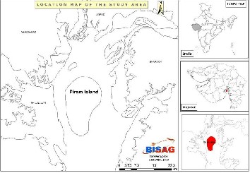
Gulf of Khambhat which is in the northern part of the Arabian Sea has a width of 80 km at mouth and funnels down to 25 km over the longitudinal reach of 140 km. Seabed in most part of the Gulf remains in quasi steady state and it moves as sand bars with tides. Bhavnagar Port is located on the western part of the Gulf (Sanil Kumar V. et al, 2010). Piram Island is locat- ed at 21° 35' North and 72°34 East, at a distance of 7.2 nautical miles south of Ghogha and 4 nautical miles from the nearest part of the mainland (Dist. Bhavnagar, Gujarat, India) (Figure-
1).
IJSER © 2014 http://www.ijser.org
International Journal of Scientific & Engineering Research Volume 5, Issue 6, June-2014
ISSN 2229-5518
1001
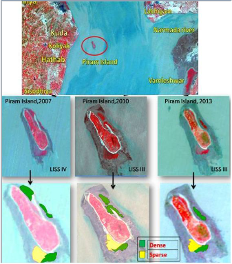
In this study Indian Remote Sensing Satellite (IRS) LISS III and LISS IV digital data of three different time periods was used. The multi-year data LISS-III data of 2007, 2010, and 2013 was analysed for mapping mangrove vegetation and monitoring changes in Mangrove cove in he Piram Issland. The location of Piram Island in the Gulf of Khambhat is shown on the IRS LISS-III digital data in Figure-2. The details of Satellite data used is given in Table-1.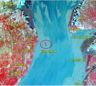
Figure- 2: Location map of Piram Isdland in Gulf of Khambhat marked on IRS LISS-III image
Table-1: Details of Indian Remote Sensing Satellite Data used
No | Satellite | Sensor | Path/Row | Date of Pass |
1 | IRS-1D | LISS-IV | 201/104 | 12-Mar-2007 |
2 | IRS-P6 | LISS-III | 93/57 | 7-Jan-2010 |
3 | IRS P6 | LISS-III | 93/57 | 3-Jan-2013 |
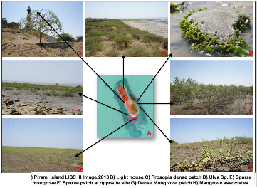
Ground truth / field verification is an important component in this project and an important source of information for verifi- cation and accuracy estimation / validation of thematic details mapped from satellite imagery. Initially a reconnaissance sur- vey was carried out to identify mangrove growing areas. Based on this information, base maps were prepared for de- tailed ground truth data collection. The details of field survey and areas of mangrove along with density observed and asso- ciated vegetation are given in Figure-3.
Figure-3:A
The soil samples were collected randomly from the study site for physico-chemical analysis. Triplicate soil samples were collected at different depths at 0-10, 10-20, 20-30 cm. The soil samples were allowed to dry at room temperature. The finally grinded soil samples were then passed through sieve of parti- cle size 2 mm. The pH of the soil suspension (1:2) was estimat- ed using pH meter. The conductivity meter was used to de- termine the electrical conductivity of the soil suspension (1:5).The bulk density was determined using w/v method.
The IRS LISS-III and LISS-IV digital data covering study area was analyzed and it broadly consists of following steps:
i) multi-date data preparation and geo-referencing, ii) Admin- istrative boundary superimposing, iii) Generation of spatial information in GIS environment at the desired scale, iv) super- imposing GPS locations of mangrove sites collected during GT
IJSER © 2014 http://www.ijser.org
International Journal of Scientific & Engineering Research Volume 5, Issue 6, June-2014
ISSN 2229-5518
1002
data collection on the registered LISS-III digital data, v) identi- fication & delineation of mangrove into different density clas- ses, vi) generation of thematic maps showing extent of man- grove areas and v) area estimation under mangroves and change detection in the mangrove vegetation and density clas- ses.
The methodology flow chart of satellite data analysis and
Mangrove mapping procedure is given in Figure-4.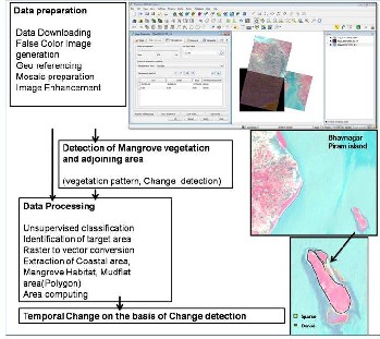
The multi-date satellite LISS-III digital data have been inter- preted visually for mapping mangrove cover in the Piram Is- land. The mangroves have been classified into two classes namely dense mangrove and sparse mangrove based on the intensity of pink tone observed on LISS-III images. On IRS LISS-III False Colour Composites (FCC) mangroves occur in bright red colour if it is in continuous patch. When mangroves are scattered or degraded then instead of bright red colour, a light brick red colour may be seen.
The mangrove mapping was carried out using IRS LISS-III images of 2007, 2010, and 2013. The Quantum GIS software was used for mangrove delineation and computation of area. The Ground Truth information about mangrove density was superimposed on the IRS LISS-III data before mapping of mangrove classes. The Google images and Wikimedia were also used for reference purpose. There were only two man- grove species were recorded from the study site. This area is directly exposed to the ocean with rocky sandy-muddy sub-
strate. Avecinnia marina and Prosopis chilensis are the domi- nant species. The mangrove delineation was carried out using Quantum GIS (Q-GIS) software. The vector features were transformed to raster features using polygon formation and polygons were attached with polygon IDs and assigned labels such as mangrove-dense, sparse, degraded, mudflat, etc. The two mangrove density classes identified on IRS LISS-III data along the Piram Island coast are shown in Figure-5.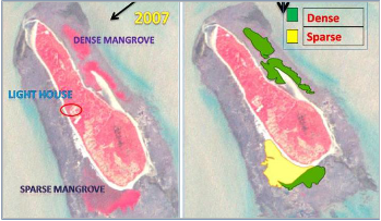
IRS LISS-III digital data of 2007, 2010, and 2013 was used ana- lysed for mapping and monitoring changes in mangrove vege- tation in the Piral Island. The mangrove density classes of dense and sparse mangrove were mapped along the coastal areas of Piram Island using Q-GIS open source software. The detailed Ground Truth information along with GPS measure- ments were superimposed on the LISS-III images for accurate identification of Mangrove as well as its density classes. The IRS LISS-III and LISS-IV data covering Piram Island of 2007,
2010 and 2013 along with mangrove density mapping is given in Figure-6.
The area estimates of mangrove mapping based on IRS LISS- III data analysis of 2007, 2010 and 2013 are given in Table-2.
Table-2: Temporal Change of Mangrove vegetation on Piram
Island and its comparison
IJSER © 2014 http://www.ijser.org
International Journal of Scientific & Engineering Research Volume 5, Issue 6, June-2014
ISSN 2229-5518
1003
The IRS LISS-III Images clearly indicate the decrease of the mangrove area over the period of 7 years from 2007 to 2013. Mangrove exhibited a marginal decline in the area from 0.326 to 0.236 sq km during this period. The Department of Ocean development, Government of India, also mapped the man- grove area on the Piram Island during the period of 12 years from 1987 to 1999 using the Satellite data and their results also indicate the decrease in the area from 0.74 to 0.57 sq km (Ta- ble- 2). The comparative results of both the studies are plotted in the graph given in Figure-7.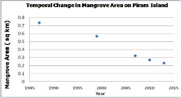
The temporal changes study result revel that mangrove area are consequences decreasing (Table-2 & Figure-7). It can be observed in table and figure that mangrove areas are subse-
quently decreasing on the Piram Island due to various devel- opmental activities. The risk of oil spill is present at the Island because of Ship breaking yard at Alang. As the tidal current velocity is high at the Gulf of Khambhat, the movement of oil slicks towards mangrove areas especially during high tides is significant and a matter of concern for its impact on mangrove vegetation.
The results of soil analysis indicate the soil texture of Piram Island is sandy. The statistical analysis shows that the soil samples collected from this area are alkaline in nature. The Electrical Conductivity range is 13.4 to 22.8 mO (18.1±0.227). The hydrogen ion concentration ranges between 8.0 to 8.95 (8.6±0.023). The % Organic Carbon and Soil Organic Carbon content varies between 3.0 to 3.95 (3.6±0.018) and 33.57 to
82.68 mg c ha-1 (52.7±1.22). Anoxic conditions and prevalence of high pH values may be partially responsible for high con- centrations of organic carbon.
A non significant (p < 0.001) negative correlation were ob- tained between pH, EC and SOC (r2 = -0.313, -0.400 and
-0.318). However, highly significant (p < 0.001) positive corre- lations were observed between BD and SOC (r2 = 0.995), BD and %OC (r2 =0.519), %OC and SOC (r2 = 0.573). A highly sig- nificant positive (p < 0.001) correlations were obtained be- tween Depth and %OC (r2 = 0.516) (Figure-8).this phenome- non indicate that %OC increases with the depth. Long periods of tidal flooding and low decomposition rates result in sus- tained anoxic conditions (below 10 cm depth) and high con- tent of organic matter, which may explain the higher values in organic matter content at 30 cm depth (Ceron- Breton et al,
2011) .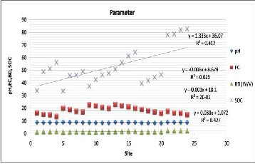
The Soil Organic Carbon rapidly increases with depth which indicates that a small fraction of carbon that is being intro- duced into the soil remains there. This pattern is typical of Swam forests where organic matter and nutrients accumulate
IJSER © 2014 http://www.ijser.org
International Journal of Scientific & Engineering Research Volume 5, Issue 6, June-2014
ISSN 2229-5518
1004
in soil layer. We can conclude that the accumulation of organic matter and carbon storage are determined by the rate of decay and the production rate of organic matter. The soil has high carbon content rather than any other terrestrial ecosystem ow- ing to the site is flooded all the time and the combination of anaerobic conditions increases the productivity of the system.
In the present study, Indian remote Sensing Satellite (IRS-P6) LISS-III and LISS-IV digital data covering Piram Island for the period of 2007, 2010 and 2013 have ben analysed for mapping mangroves. The LISS-III and LISS-IV data have been interpret- ed visually and the mangroves have been classified into two density classes namely, dense mangroves and spares man- groves based on the intensity of pink tone observed on the Satelllite data. Field Survey was carried out for mangrove density identification with the help of GPS measurements at various places in the Piram Island. During field visit soil sam- ples were also collected for physical chemical analysis. Remote Sensing data was analyzed using ENVI Software and the mangrove density classes were delineated using the Quantum GIS software. The physico-chemical properties of soil of vari- ous sites in the Piram Island were also studied.
The results of this study on change monitoring of mangroves in the Piram Island indicate that:
• Mangrove area has been consecutively declining from 0.74 to 0.23 sq km in the Piram Island during the period from
2007 to 2013.
• Change detection study was carried out for monitoring mangrove status in Piram Island and results were com- pared with the mangrove estimates carried out by the De- partment of Ocean Development (DOD), Government of India.
• DOD carried out the mangrove mapping using the satel- lite data of 1987 and 1999 covering Piram Island and the results indicated that the mangrove area has decreased from 0.74 to 0.57 sq km.
• The results of present study on change monitoring revels that mangrove area is consecutively declining from 0.74 to
0.23 sq km in the Piram Island.
• Soil samples were also collected and analyzed for parame- ters like pH (8.6), Electrical Conductivity (8.6 mO), Bulk Density (1.5 w/v), %Organic Carbon (3.6%) and Soil Or- ganic Carbon.
• The organic carbon and soil organic carbon is greater at 30 cm depth. The correlation between parameters is also studied in detail.
• The mangrove area has very high potential to sequester the carbon which can be increased further in future by
conserving or protecting the mangrove areas in the Piram
Island.
• This study gives clear idea to land managers in imple- menting conservation initiatives for mangroves as well as protection of Piram Island.
The authors like to express their sincere thanks to Shri T. P. Singh, Director, Bhaskarcharya Institute for Space Applica- tions and Geo-informatics (BISAG), Department of Science & Technology, Government of Gujarat, Gandhinagar 382007, and Team Members of BISAG, for fruitful discussions, sugges- tions and continuous cooperation in carrying out this project.
1. Anonymous (2013). Integrated Environmental Impact As- sessment of Proposed Open Cast Mining at Ghogha- Surka, Khadsaliya-II and Khadsaliya-I Lignite Mines, Bhavnagar District, Gujarat, Project Report, National En- vironmental Engineering Research Institute, Nagpur,
page 401.
2. Anonymous (2009). Piram Isaland, http://piramislanddeveloper.com/business.html, Downloaded on 15th July, 2013.
3. Bhavsar D. O., Jasrai Y. T. and Pandya H.A. (2013) The Impact of Aquaculture on Indian Mangroves Ecosystem: A Case Study of Olpad Taluka, Surat, India, International Journal of Recent Scientific Research, 4(12), 2016-20.
4. Bunting S W and Pretty J (2007) Global carbon budgets an aquaculture - emissions, sequestration and management options. Centre for Environment and Society Occasional Paper, University of Essex, UK.
5. Ceron- Breton, J.G., Ceron- Breton, R.M., Rangel-Marron, M.,Muriel-Garcia, M.,Cordova-Quiroz,A.V., and Estrellla- Cahuich,A. (2011): Determination of Carbon sequestration rate in soil of a mangrove forest in Campeche, Maxico. In- ternational journal of energy and environment, 3(5); 328-
336.
6. FAO (2007) Tshe world’s mangrove 1980-2005: FAO, For- estry Paper 153, Rome.
7. Gaur A.S (2010) Gogha: An Indo-Arab Trading Post in the Gulf of Khambhat (Cambay), India. International Journal of Nautical Archaeology, 39.1, pp.146–155.
8. GoI (Government of India, Department of Ocean Devel- opment) (2002) Critical Habitat Information System-
IJSER © 2014 http://www.ijser.org
International Journal of Scientific & Engineering Research Volume 5, Issue 6, June-2014
ISSN 2229-5518
1005
Gujarat, Project report, pp.12.
Natural Coastal Carbon Sinks, IUCN Gland, Switzerland.
11. Rajawat A. S., Gupta M., Pradhan Y., Thomaskutty A.V. and Nayak S. (2005) Coastal process along the Indian Coast- Case study based on synergistic use of IRS-P4
OCM and IRS 1C/1D data, Indian Journal of Marine Sci- ence, 34(4), pp. 469-472.
12. Sanil Kumar V. and Ashok Kumar K. (2010) Waves and Currents in tide dominated location off Dahej, Gulf of Khambhat, India, Mar.Geod, 33(2), pp 218-231.
13. Singh H. S. (2000) Mangrove of Gujarat, Current Status and Strategy for Conservation
IJSER © 2014 http://www.ijser.org