International Journal of Scientific & Engineering Research, Volume 3, Issue 1, January-2012 1
ISSN 2229-5518
Modeling a Homogenate GIS Architecture Based On Service Oriented Architecture for the Tourism Mapping Needs
Abubakar Agil Emhmed, Kalaivani Chellapan
UNIRAZAK (Universiti Tun Abdul Razak), Institute Of Space Science (ANGKASA)-Universiti Kebangsaan Malaysia
Kuala Lumpur, Malaysia abobakr_alhamaly@yahoo.com, kckalai@yahoo.com
Abstract—Location information is a set of data describing an individual geographical location. This information can be used in many ways
to provide information and entertainment services to the user who has the require devices and resources to operate such services. However, different challenges are reported in terms o availability and homogeneity. These challenges are mainly focused on the integration, standardization, security and privacy of the various GIS resources that helps to show essential but exhaustive information into a simple, clear and possibly user-friendly interface. Therefore, a simple but complete interface should provide all GIS functionalities, identified by graphically clear and easily understandable symbols, icons or texts. This paper intends to apply the Service Oriented Architecture (SOA) to re-manage the GIS resources and provide a distributed, dynamic, and reliable service system that can meet information and service requirements of many different users over the internet.
Index Terms— GIS, SOA, map locator, mobile services, web services, JSP, GIS mappping
1 INTRODUCTION
—————————— ——————————
HE deployment of new technologies in the various com- munication sectors have indicates the needs for enhancing and developing a new techniques to fit a specific purposes.
It’s become quite familiar that using mobile in our daily life has extremely extended to help users to save and retrieve a certain information through wireless services [1]. The prime reason for using mobile devices back to that mobile devices are small handheld devices such as mobile phones, palmtop computers and other devices that come with operating system. From the other hands, mobile services provide a wide range of accessibili- ty for different clients that locates in different locations, which include the most competitive technology such as the Personal Digital Assistants (PDAs) with or without networking capabili- ties that could access the Web services [2].
Even though that tourism industry is now undergoing tre- mendous change due to tourism development, but it does not stop the commercial and residential growth. The level of inno- vation is high and new technologies, devices, applications and services emerge in a rapid manner. The application of GIS can be huge and one of them is tourism. Tourism is information intensive and sensitive industry in which GIS in expected to play an important role. Tourists need well-organized informa- tion anywhere and anytime, to ensure pleasant traveling. Paper maps usually provided, but it has many limitations such as li- mited amount of details and environment changed. This paper is conducted to model an effective tourism application architec- ture based on mixture of mobile computing and GIS technology along with the SOA.
SOA helps to allow the transition from an application-centric view of the world to a process centric one. Mobile applications now have the freedom to combine business services from mul- tiple applications to deliver true end-to-end support for busi-
ness processes. SOA has a variety definitions regarding what it consists of, sometimes driven by vendor-specific solutions in- stead of a general architecture [3]. It is important that SOA is about more agile business processes and not purely a technolo- gy-driven solution. SOA is an architectural concept, and hence to realize an SOA solution, one must map the architecture to a logical construct followed by an implementation using a specific set of technologies/platforms/products [4].
Form the other hands, providing a homogenate mobile ser- vice for locating places has recognized as a challenging proce- dure for proceesing, presenting, and organizing contents based on some function to calculate the user destination and mapping the current user location. Then, this procedure is often meas- ured based on the performance and efficiency of the system.
Tourists mostly use maps before, during and after place vis- its. Before a visit, tourists usually use maps to assists them planning their activities and also learn about the general layout and social zones of cities. These pre-visit activities are increa- singly supported through web sites which may even offer inter- active maps and associated services to help with the planning of a visit [5].
2 ISSUES & CHALLANGES
Nowadays, it is become hard for individual standalone servic- es to meet all the service requirements of many users. Such service requests could be met by dynamically chaining mul- tiple services provided by single and multiple service provid- ers. These challenges were clearly defined by Dogru and Toz (2008) stated the flexiability of using SOA to recognize these challenges and tries to construct a distributed, dynamic, flexi- ble, and re-configurable service system over Internet that can
IJSER © 2012
http://www.ijser.org
International Journal of Scientific & Engineering Research, Volume 3, Issue 1, January-2012 2
ISSN 2229-5518
meet information and service requirements of many different users [6].
Furthermore, the process of managing GIS information into classified sets is found to be a problematical task especially for hand-held devices and the request-response delay increases based on the hardware and software provided. From another side, a various drawbacks were demonstrated, which involves the connection, delays and high response times. These issues are wished to be eliminated with the development of a suitable GIS architecture. This was indicated also with stand-alone applica- tions that don’t require any communication with a remote source during the execution.
GIS application server is employed to update the GIS infor- mation and user profile details frequently. This allows the GIS system administrator or the manager to add, delete, and update the relevant GIS information very quickly as well as work with information at the last level of updating.
GIS functions vary depending on the use that mobile GIS have been thought for. So, basic functionalities of map viewer such as zoom in, zoom out, query such as feature query and attribute-based query, and editing information, while other functionalities, such as search place, register service controls are added for characterizing the service. This back to the limitation of physical constraints of hand-held devices, such as small screen, small memory storage, and low frequency of CPU, some critical issues must be taken in account.
Fangxiong and Zhiyong in [7] addressed the difficulties for displaying the GIS contents over the client devices of WAP- based Mobile GIS. They acknowledged that such devices need a suitable mechanism to be installed on the server to determine the client device and generate corresponding presentation logic for the client.
By consequence a mobile GIS is required to show essential but exhaustive information into a simple, clear and possibly user-friendly interface. This aspect become even more impor- tant when the mobile GIS is oriented to the users such as travel- ers. Therefore, a simple but complete interface should provide all GIS functionalities, identified by graphically clear and easily understandable symbols, icons or texts. To make essential and exhaustive the displayed geographic content, Mobile GIS have to face the challenges of map generalization, i.e. how to vary maps depending on the scale without loss of information for a given scale, and map schematization, which can be considered an effective mean of generalization at large scales, to make con- tents user friendly for interpretation [8]. Several implications, such as generalization, assortment, displacement and combina- tion of features, are necessary to create maps with features sim- plified in form or shape [9].
Another reason for developing a new SOA architecture for GIS application is that all the and-held devices have low memo- ry capacity, which mostly consume within 64 MB against at least 512 MB of desktop PC with a low frequency of CPU at 400
MHz against 4 GHz of desktop PCs. This affects on the devel- opment of GIS functionalities for mobile, because such a limita- tion doesn’t consent to provide a high CPU stress operations. Therefore, many functions of data analysis available on desktop PC cannot be moved on Mobile GIS. Thus, WMS (Web Map Services) and WPS (Web Processing Services) can be considered as a potential solution, because they enable the GIS server side operations to be performed highly, while the client has only to call the service and to manage the response. Thus, this paper aims to design a new GIS architecture for the tourism mapping needs based on the classification of SOA.
3 COMPARISON STUDY
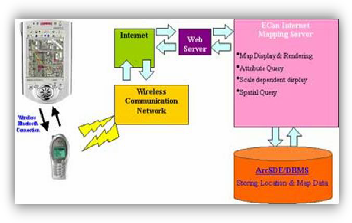
Today, most of the handheld devices have the necessary built- in hardware [10]. Location Based Services (LBS) are informa- tion services that provide users with customized contents such as the nearest restaurants, hotels, clinics, petrol pump from the dedicated spatial database based on the user’s current location [11]. Figure 1 presents the initialization of GIS into mobile ap- plication for retrieving and displaying the location details re- motely.
Fig 1. GIS Services through Mobile [11]
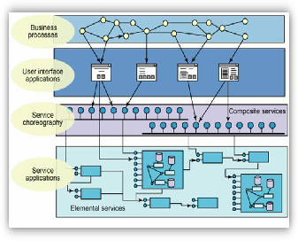
Service Oriented Architecture is considered as a collection of different services such as converting the business applications into individual business functions and processes and security between enterprises that transferred via the Web [12].
Nevertheless, different number of layers can be adopted while using SOA in system development as shown in Figure 2.
IJSER © 2012
http://www.ijser.org
International Journal of Scientific & Engineering Research, Volume 3, Issue 1, January-2012 3
ISSN 2229-5518
Fig 2. SOA Components [4]
According to Nie, et al. in [13] proposed a design and im- plement of a tourist route planning and navigation system based on LBS. This system called TRPNS which helps tourist to arrange travel route and navigate tourist through the chosen travel route. By the help of LBS, the portable devices are aware of its location and can query the back-end system for the up- dated information about the local sites of interest in anytime and anywhere. The proposed system allows a tourist to plan a specific day, find places, shopping, hotel, airport, interesting/ beaches, provide value-added services according to his/her preferences.
Another scholar by Neteler and Raghavan in [14] conducted his research on the digital cities, mobile applications and Geo- graphic Information Systems (GIS) tourism applications. He proposed a prototype location-aware outdoor application to help people navigate through a city with a mobile handheld device. The research embraces the above areas as well as re- search on building recognition through image processing. His system helps people locate their positions and identify the buildings from user-supplied Personal Digital Assistant (PDA) images, as well as GPS and orientation data, is presented.
As stated in [15] implemented system framework, designed efficient algorithms of a GIS system, called Intelligent Map Agent (IMA) system. The main focus of the IMA is to provide access to services, which require the usage of spatial data and information, to mobile users regardless of their location. The IMA can accommodate a large number of mobile users and ser- vices which distributed across a wide geographical area. The system represented by agents using JADE/LEAP technologies.
3 PROPOSED ARCHITECTURE
A number of stages were involved in this research to design and develop an efficient GIS architecture.
A number of solutions were developed and executed for

mobile GISs in terms of two groups, client server architectures and stand alone applications, which carried different advantag- es and disadvantages. Mobile GIS client-server solutions, are usually considered as derivative of Web GIS as acknowledged by [16]. They estimated that the mobile GIS presents the client side is constantly linked to a wireless network that helps to connect with the server. Such process was used in order to pro- vide a reliable schema for sending the request details and re- ceiving responses through Internet services. Frequently a “four- tiered architecture” is executed in terms of; the client tier that includes the desktop GIS, web processing services, and mobile GIS applications, application server tier that includes web map services (WMS), GIS Application Server, java platform, geospa- tial model language, GIS application server, and Data Base (DB) server, service tier that includes web map services, client-server application, LBS, and java scripts, and geo database tier that includes places information, map viewer, MySQL, PostGIS, Geo-data Repositories. Consequently, a client-server application allows establishing a real-time connection with the server, that provides data and services, and, by consequence, allows getting up to- date information, which relies on the request execution. LBS services were integrated to allow user or the manager to edit their details based server at real-time and contribute to up- date the database in order. MapfileManager.java was also used to generate contrast-language-based MapFiles as shown in the typical procedure below:
1 enables the generateAllMapfiles method, which estab- lishes the process for every contrast-language combina- tion
2 enables the generateMapfile method, which aims to product a MapFile
3 look through the Mapviewer file
4 enable the etMapfileHc method to switch to high con- trast settings
5 call for query results
6 enable naming and saving the generated MapFile
The constructing of SOA without bearing in mind the main considerations of client-server side, may address presence of obstacles make difficult in some cases to get connected and to have a correct and normally fast interaction between client and server.
The SOA service function is well defined with LBS and UMN
& JavaScript to create robust connection. The service starts by sending message and establishing to the connection by response
the message. The request and subsequent response connections are define in some way that is understandable to both the ser- vice consumer and service provider. However, two fold data capture requirement has been adopt from Klippel, Worboys and Duckham, 2006. In the beginning, it must provide automatic loggers, capturing data and store into the database [17]. Finally, system must be able to convert data to structure compatible with the data model for the database, checking validity and integrity of the data. Figure 3 elaborates and presents the pro- posed SOA architecture for mobile GIS.
IJSER © 2012
http://www.ijser.org
International Journal of Scientific & Engineering Research, Volume 3, Issue 1, January-2012 4
ISSN 2229-5518
Desktop GIS Appli- cation
Web Processing
Services
Mobile GIS Applica- tion
Client Tier
Mobile service interface
Distributed Component
CCaacchhee ((offff-l-inlien)e)
Web Map Service (WMS)
Internet
Internet
Application Server Tier
Java Platform
Geospatial Model Language (GML)
DB Server
GIS Application Server
Service Tier
Metadata-XML
Geo Database Tier
Places Infor- mation
Map Viewer MySQL PostGIS Geo-data
Repositories

Fig 3. SOA Architecture for GIS
IJSER © 2012
http://www.ijser.org
International Journal of Scientific & Engineering Research, Volume 3, Issue 1, January-2012 5
ISSN 2229-5518
4 DISCUSSION
Deploying the homogenate GIS architecture could result the following:
- Provide a reliable performance;
- Enable users to display information easily;
- Provide flexibility especially with other GIS services;
- Provide mapping services based on the Geo database tire;
- Deals with different users based on the client tire;
- Works together with other services based on the ap- plication server tire;
- Allow to add on other services based on the services tire;
5 CONCLUSION
Providing a reliable and flexible GIS services has appeared to be a wide speared issues on the handheld devices. Modeling a new GIS architecture to re-organize the GIS information in a definite mechanism could help to overcome these issues. Thus, this pa- per was conducted to model homogenate GIS architecture based on SOA for the tourism mapping purposes. A number of previous researches were demonstrated in this paper for detail- ing the possibility of using various tools into the proposed GIS architecture.
ACKNOWLEDGMENT
The authors wish to thank his supervisor Kalaivani Chellapan for her valuable support and guidance.
REFERENCES
[1] D. Goren-Bar, "Overcoming mobile device limitations through adaptive information retrieval," Applied Artificial Intelligence, vol.
18, pp. 513-532, 2004.
[2] N. M. Suki, "Mobile phone usage for m-learning: comparing heavy and light mobile phone users," Campus-Wide Information Systems, vol. 24, pp. 355-365, 2007.
[3] N. Bieberstein, et al., "Impact of service-oriented architecture on enterprise systems, organizational structures, and individuals," IBM systems journal, vol. 44, pp. 691-708, 2005.
[4] R. Saha and A. Patel, "Processing of Service-Oriented Tasks within a Grid Computing Environment," ed: Google Patents,
2009.
[5] M. Norrie and B. Signer, "Overlaying paper maps with digital information services for tourists," Information and Communication Technologies in Tourism 2005, pp. 23-33, 2005.
[6] A. Dogru and G. Toz, "Development Of A Service Oriented Architecture Based Gis For Earth Sciences," in ISPRS Beijing- China, 2008, pp. 763-766.
[7] W. Fangxiong and J. Zhiyong, "Research on a distributed architecture of mobile GIS based on WAP," 2004, pp. 12-23.
[8] S. Anand, et al., "Generalisation of large-scale digital geographic
datasets for mobilegis applications," Dynamic and mobile GIS. CRC Press, Taylor & Francis Group, pp. 161-168, 2007.
[9] J. M. Ware, et al., "Automated map generalization with multiple
operators: a simulated annealing approach," International
Journal of Geographical Information Science, vol. 17, pp. 743-769,
2003.
[10] M. Petit, et al., "A contextual approach for the development of GIS: Application to maritime navigation," Web and Wireless Geographical Information Systems, pp. 158-169, 2006.
[11] B. Jiang and X. Yao, "Location-based services and GIS in perspective," Computers, Environment and Urban Systems, vol. 30, pp. 712-725, 2006.
[12] C. M. MacKenzie, et al., "Reference model for service oriented architecture 1.0," Architecture, vol. 2006, pp. 1-31, 2006.
[13] Y. F. Nie, et al., "A Tourist Route Planning and Navigation System Based on LBS," in Proceedings of the 2009 International Symposium on Web Information Systems and Applications (WISA’09), Nanchang, P. R. China, 2009, pp. 88-290.
[14] M. Neteler and V. Raghavan, "Advances in free software
geographic information systems," Journal of Informatics, vol. 3,
2006.
[15] J. Yi, "A ubiquitous gis: framework, services and algorithms development," Carleton University Ottawa, Ont., Canada, 2009.
[16] A. Mansourian, et al., "Development of New Generations of Mobile GIS Systems Using Web Services Technologies: A Case Study for Emergency Management," Journal of Applied Sciences, vol. 8, pp. 2669-2677, 2008.
[17] A. Klippel, et al., "Geographic event conceptualization,"
Cognitive Processing, vol. 7, pp. 52-54, 2006.
IJSER © 2012
http://www.ijser.org