International Journal of Scientific & Engineering Research Volume 2, Issue 8, August-2011 1
ISSN 2229-5518
Land Use in Suburbia: Perungalathur Village of Chennai Metropolitan Area
Dr. S. Ramesh1, N. Nagarajan2, Dr. S. Poongothai3
Abstract— Land use of a region is a function of use of land, community, attitude of people in their daily walks of life, occupation of the region and finally location, rate and quantum of interaction irrespective of distance with the nodal point at the region. The functionality of the region differs from place to place and remains a key factor in Suburbia. Land use is obviously constrained by environmental factors such as soil characteristics, climate, topography, and vegetation. Subject of geography deals with the study of space and the nature of people who live in it and how they advocate for the changes taking place over the region, which is clearly exposed by an understanding of the literal meaning of suburbia. The suburbanites as a distinctive social element and secondly the manners, styles and customs typical of suburban life. This reveals that the nomenclature of the region wholly depends upon the intensity and type of use of land by the people. The paper aims at examining the evolving land use patterns in a Suburb of Chennai, namely, Perungalathur. The spatial and temporal variations are studied from the land use maps prepared at the Cadastral level, demographic and occupational structures of the region for the periods of
1960 – 2001 are also discussed. The Change Deduction analysis is used in the study for understanding the evolving land use pattern. By viewing the data obtained from the Adangal (Revenue Record Book) and Census data, the study suggests that this region is subjective to higher rate of land use conversion, that is, from agriculture to plots, residential its allied activities such as shops (petty shops, construction related shops) which indirectly exposes the nature of change in occupation pattern and the pull factors which have invited a change in demographic pattern of the region which elucidates the evolving land use pattern.
Keywords: Land use pattern, Suburbia, Cadastral level, Change detection in demographic pattern
—————————— • ——————————
due course, the suburbs turn into self-sufficient urban areas
and are not partaking in the city development.
INTRODUCTION
se of any land, rural or urban, is subjective. Human beings in the locality control changes in land uses and the amount of changes depends upon the nature of
accessibility and land use amenability of the natural re- sources (Vink, 1975). Other factors that indirectly contribute to changes in the use of land are government policies and development taking place locally and in adjacent areas. Ouřendníček (2007) put forth reasons for de-concentration of residential development processes, differing considera- bly in migration, motivation, relationship to core city, qual- ity of housing, and impact on source and target of the lo- calities during the course of sub-urbanisation in Paraguay. Hence, it may be ascertained that reasons for constant change in land use depend upon a wider range of issues, and connote areas by various terminologies, namely, urban, rural, urban fringe and edge cities.
Suburban fringe is a region of absorption of infrastructural facilities from the city, growth in population and residential development as it leads to changes (Hudson, 1973). Slovak (1985) quotes the content of a paper on Sternlieb and Huges as “People and jobs have moved to the suburbs at hefty rates, and with them have gone many facilities - shopping centres, restaurants, sports and entertainment complexes - once monopolized by cities”. Their main argument is to prove how suburbs evolve from expenditures on Cities. In
————————————————
1 Kendriya Vidyalaya IIT Madras, IIT Campus, Chennai, Tamil Nadu, India. e-mail: sadasivam.ramesh@gmail.com
2 Asst. Professor, Dept. of Civil Engg., FEAT., Annamalai University, Annamalai Nagar, Tamil Nadu, India. e-mail: nnrajan.au@gmail.com
3 Professor, Dept. of Civil Engg., FEAT., Annamalai University,
Annamalai Nagar, Tamil Nadu, India. e-mail: spoong86@yahoo.com
Similarly, the term ‘suburbia’ gets its significance because of its differing nature of development, community setup, societal organisation and human behaviour when com- pared to adjoining areas. Cunningham (2004) says that suburbia is physically indeterminate and shifting. The cha- racteristics of urbanisation include expansion of suburbs, increased road density, and upgradation of roads and other related infrastructures that lead to conversion of land uses (Theobald, 2005).
Land uses at the fringes of metropolitan cities, especially in developing countries, are forced to undergo a process of transformation, seamlessly, due to various politico-socio, economic and technological developments taking place. The basic difference between city and suburban is one of socio-economic levels (Kirschenbaum, 1972). The process of development takes place in all walks of life, within and specifically along, the fringes of the metropolitan area, irre- spective of the distance factor. It leads of course to large variations, spatially as well as in the livelihood patterns of residents.
Land use conversion, that is, the farmlands located at the suburbs get into a cycle of development, namely, layouts and vacant land for future development. Layouts inherit the characteristics of various land uses and as such land devoted for commercial purposes within the residential area, public spaces namely park and public sanitation plac- es. Similarly, plots devoted to residential development take up new forms of development such as apartments, duplex houses and row type of houses. It explains the nature of modification in land uses of an area and adds richness to the complex urbanisation process.
Composition of land uses or combination of land uses in the suburbs increases the intensity of urban problems. The
IJSER © 2011
http://www.ijser.org
International Journal of Scientific & Engineering Research Volume 2, Issue 8, August-2011 2
ISSN 2229-5518
phase of infra-structural development is slow when com- pared to growing population of the suburbs. The literal meaning of suburbia, according to the Webster dictionary, is that of “the suburbanites as a distinctive social element and secondly the manners, styles and customs typical of suburban life”. A Shorter Oxford dictionary meaning is: “the residents or their way of life in the suburbs of a city”. The Macmillan dictionary describes it as “the people who live in them, or their way of life”.
Land is an independent component. In it the humans inter- act with all their potentiality for their survival. Human be- ings are a major interactive element whose interaction is such that the process of interaction remains dynamic and complex in order to support their survival. The result of the catalyst process can be visualised in nature and in its sub- jectivity. It varies over the regions of the earth’s surface. According to Vink (1975), “Land use is the application of human controls, in relatively systematic manner and is a key element within any ecosystem with which the man tends to derive the maximum benefits”. The process of ur- banisation has led to, in certain regions, an adaptation of the characteristic of the nodal point. As the net impact of interaction, and also with the inherited characteristics pos- sessed by the region, the resultant impact may be visualised as a new form as land use is emerging in the region, on a larger scale.
Land use of a region is a function of use of land, commu- nity, and attitude of people in their daily walks of life, oc- cupation of the region and finally location, rate and quan- tum of interaction, irrespective of distance with the nodal point of the region. The functionality of the region differs from place to place and remains a key factor in suburbia (http://www.ciesin.org).“Land use is obviously con- strained by environmental factors such as soil characteris- tics, climate, topography, and vegetation”.
Aim and Objectives
The study aims at examining the evolving land use patterns in the suburbia of Chennai, taking Perungalathur as a case in point. The objectives of the study are:
• To analyses changes, spatial and temporal in suburban land uses with a case in point, and
• To assess the nature of development in the suburban area in the context of local economic development.
Study area
Location and Geographical Extent
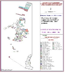
Perungalathur is located in the southwest of Chennai City, in the Chennai Metropolitan Area. The latitudinal extent is from 12o 56’ 54” N to 12 o 53’ 43” N and the longitudinal extent is from 80o 04’ 41” E to 80o 06’ 07” E (Figure 1). The extent of the study area is 702 ha. This peri-urban place is located at 3 km from Tambaram Town, which is a tradi- tional market area on the eastern side. Further, it is a nodal point, which serves as a social area of the southern suburb. Connections between Perungalathur and Tambaram are very frequent as they help in the movement of goods and
services from the city to the suburb.
Demography
This suburb has registered a population growth of 5.70 per cent during the period 1971 to 2001. Further, spatially, a majority of the population is distributed along the rail line, major streets and around the water bodies. Recently, there has been a shift in the concentration of population, irrespec- tive of distance to the road or rail line due to increase in vehicular traffic. In the present occupational pattern, there are 105 agricultural labourers, 62 cultivators, 6,290 main and marginal workers and 43 persons working in the household industry. Other workers are 6,087 as per 2001 census. The proportion of other workers to that of the total population is 31 percent and this reveals that there is a change in the attitude of the people inculcating the need for land use change.
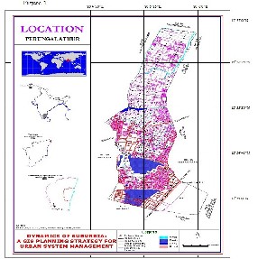
Table 1 Population data of the study area (1961-2001)
Year | Total Population |
1961 | 1,633 |
1971 | 3,714 |
1981 | 6,185 |
1991 | 11,235 |
2001 | 19,343 |
Source: Census of India
Table 1 above shows the population distribution of the suburban Perungalathur. There has been a great increase in population in the last four decades. The population has trebled during 1961-71 and again during 1981-2001.
Water Bodies
The major occupation of the people here is agriculture,
IJSER © 2011 http://www.ijser.org
International Journal of Scientific & Engineering Research Volume 2, Issue 8, August-2011 3
ISSN 2229-5518
which is borne out from the presence of irrigation tanks. This peri-urban area consists of two major tanks, namelt, Periya Eri and Sitheri, located in the southern and south central parts of the suburb. Minor tanks and ponds (Kuttai) are scattered and the notable one is Vannan Kuttai. Apart from it, a stream (Odai) that divides the suburbs into two parts. There is a channel connecting the Periya eri with the Sitheri. The stream runs along the eastern margins for a few kilometres.
Transportation
The study area is served by the NH45, which passes through the suburb for about 1.5 km in the southern part; further, the rail lines, metre and broad gauges (MG, BG) run parallel to it. Apart from the highway, the suburb is also served by a bypass road, which runs from east to west and leads to Kancheepuram town, an ancient heritage and market town via two small market and professional towns, namely, Padappai and Wallajabad. On the whole, transport is very well established.
History and Growth of Village
According to oral accounts of the farmers and merchants, they interacted with Chennai city on a daily basis in order to sell agricultural products such as roses and samphengi, another local variety of flowers. During the course of inter- action, they purchased the daily requirements on a weekly basis. Some merchants say that they purchased goods of daily need in small quantities and sold them in local mar- ket. In due course of time, when the Standard Motor Com- pany was established during the 1950s, the people started settling down along the adjacent area, irrespective of the land category: wet or dry and grazing land. Further, the train, which crossed the suburb around noon, was called
‘Sambar Train,’ but it did not stop at the suburb. Later on, in response to the demand from the workers, the railway
station was built. As a consequence, the suburb turned out
to be a pull factor for the employees to get settled near the company.
During the mid 1980s, when the factory was shut down, the workers of the factory turned to do some petty businesses
as purchasing goods from the city and selling them in the local market, while a few others started constructing houses
for renting. But currently, as there is a change in the atti- tude of the people as well as in the policy of the govern-
ment in response to Globalisation, the suburb came to pos- sess many employment opportunities for people. This has
also forced the people from other suburbs of the city and also the city to migrate and settle down in the suburb.
Methodology
Mapping
• The maps have been generated from Filed Meas- urement Book (FMB’s) using data building tech- nique;
• The generated data have been geo-referenced, coded with the aid of data dictionary;
• The consistency of the digital data in terms of
‘area’ has been validated using standard deviation technique;
• Spatial data have been linked to aspatial data;
• Generalized land use maps have been prepared for
3 decades from 1963 to 1985; and
• A detailed land use map has been prepared and the change detection analysis was performed.
Secondary Data
• The land use details have been collected from the taluk office, especially from the “adangal” for the years 1963-64, 1973-74, 1984-85, 1990-91, 2000-01 and 2004-05.
Techniques of Analysis
• Change detection analysis has been used for identi- fying the temporal variations for the years 1990-91,
2000-01 and 2004-05.
Software used
• AutoCAD, Arc/Info, Arcview GIS
Limitations
• Due to non-availability of subdivision numbers in the record sources (FMBs), the data have been gen- eralized and parcel based land use change detec- tion has been performed;
• Generalization of non-spatial datasets has been made and coded; and
• Compilation of the census data.
Results and Discussion
Land use of any place is subjected to change in response to market forces and irrespective of distance from the city. The impact of Chennai City is one of the foremost reasons be- hind land uses of the suburbs. As this suburb was devoted to agriculture for decades, changes were fast paced due to the policy of globalization and due to changes in the atti- tude of the people of the locality. The city and the adjoining areas have responded well through residential develop- ment and related activities. The people of this suburb commute to the city, and to the nearest town and other parts of the region in search of Jobs and also shopping for basic goods. As a consequence of the movement of people, there has been an increase in the vehicle traffic in both the National and State Highway corridors and an increased pace of development in infrastructural facilities along the transport corridors. As the low land value and non- polluted environment invited a large number of people to make use of this suburb as the residential enclave, and fur- ther this suburb was on the verge of becoming a suburban
IJSER © 2011 http://www.ijser.org
International Journal of Scientific & Engineering Research Volume 2, Issue 8, August-2011 4
ISSN 2229-5518
residential enclave of the metropolitan area.
This has forced an increase in the intensity of land utilisa- tion, as desired by the community. Changes in the land use pattern are drastically taking place and can be explained by the land extent devoted to particular uses. Simultaneously, there is an increase in other land use categories; apart from that, there is introduction of new land use patterns in the region. It is revealed from the following land use maps (Figure 2 – Figure 7) that there is an increase in the use of land for diversified activities, particularly, in some parts of the suburb. There is an increase in the extent of residential area and decrease in the fallow and agricultural lands. In other parts of the suburb, land use was in great flexibility. It may be because of the natural and local economic forces that are effective in bringing out the suburb’s responses to changing economic opportunities.
Physically, there is an increase in petty shops and commer- cial activities, especially construction related establishments and there is loss in the traditional construction establish- ments, which used to sell materials for thatching the houses. There has also been a symbolic representation of changes in the land uses and occupational patterns of the
suburbia. 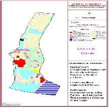
IJSER © 2011 http://www.ijser.org
International Journal of Scientific & Engineering Research Volume 2, Issue 8, August-2011 5
ISSN 2229-5518
Trends In Land Use Pattern
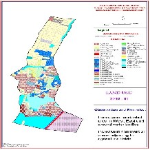
During 1963-64, the original settlement was only at the cen- tre of the village. There was a small settlement, its overall extent being 33.02 ha, which was 4 per cent of the total area. During 1973-74, there was a marginal increase of 0.1 per- cent of the area of settlement. During 1984-85, the percent- age of residential land use was 12, and this was when peo- ple began to settle mostly along the borders of the minor roads.
CHANGE DETECTION
The change detection analysis for the years 1990-91 and
2000-2001 reveals that 20.86 ha of fallow lands in the north and eastern parts of the suburb have been converted into
housing plots, 14.98 ha of fallow lands in the central and eastern parts of the suburbs have been converted directly
into residential areas. Similarly, 6.80 ha of the land devoted to rice cultivation have been converted into residential
lands. During this period, 13.60 ha of land devoted to water bodies and residential activities were converted into places
of public services and residential areas. In general, how- ever, the natural conversion of land uses was from the fal-
low of rice and of floriculture.
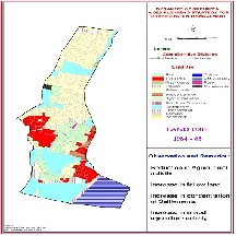
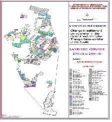
The change detection analysis for the years 2000-2001 and
2004-05 exposes the nature of change in the land use pat- terns: 13.45 ha of fallow land have been converted into
plots, 14.10 ha of fallow land have been converted into resi- dential areas. In the eastern and central parts of the sub-
urbs, 17.26 ha have been converted into residential uses. Similarly, 3.79 ha of rice cultivated area has been directly
converted into residential uses (Figure 8 – Figure 9).
While studying the nature of change in land uses, it has become known that some places within the suburbs are susceptible for higher levels of change and they are not con- fined to the hierarchical development.
MAPPED LAND USES AND THE FINDINGS
From the maps of land uses of different periods, the following have been extracted.
Land Uses 1963-64
• Predominant occupation: agriculture
• Agriculture is concentrated in the eastern and cen- tral portions of Perungalathur
• Land in the north is under fallow
• Buildings are in the central parts and along the transport corridors of the south
IJSER © 2011 http://www.ijser.org
International Journal of Scientific & Engineering Research Volume 2, Issue 8, August-2011 6
ISSN 2229-5518
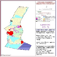
Land Uses 1973 –74
• Major activity is primary - agriculture
• Minor changes in the cropping pattern in the cen- tral and eastern parts
• Land in the north is left fallow
• Settlement is concentrated along the central and along the transportation corridors of the south
• Emergence of new settlements in the eastern por- tions
Land Uses 1984-85
• Reduction in agricultural activity
• Increase in fallow land
• Increase in concentration of settlements
• Increase in mixed agricultural activity
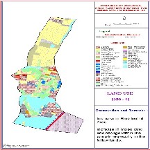
Land Uses 1990-91
• Increase in residential area
• Increase in mixed land use change within the par- cels, especially in the fallow land region
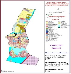
Land Uses 2000-01
• Increase in residential area in the west, east and around water bodies
• Increase in commercial areas adjoining to agricul- ture fields
Land Uses 2004-05
• Increase in residential areas in the north
• Reduction in variations of land use pattern within the land parcels
• Reduction in fallow lands
CONCLUSIONS
IMPLICATIONS FOR SUBURBAN DEVELOPMENT
The rate of suburbanization viewed through the extent of land use changes indicates that the residential development and related establishments play a key role in the growth of the suburb. The nature of changes in land uses on the whole determines that in future this suburb would largely be a residential enclave.
IMPLICATIONS FOR LOCAL ECONOMIC DEVELOPMENT
The growth in population, changes in occupation and land use patterns, give us the inference that there is a higher scope for development by means of increases in fixed assets of the suburb, which are indeed the wealth of the suburb.
IMPLICATIONS FOR SUBURBAN POLICY
Hence, it becomes essential to emphasize planned devel- opment at the initial stages, to vacate or regulate the exist- ing unauthorised developments and to have thorough knowledge about the global policies and to formulate new policies for land use development and local economic de- velopment, based on these.
REFERENCES
(1) Alan, Kirschenbaum 1972: City-Suburban Destination Choic- es Among Migrants to Metropolitan Areas, Demography,
9(2): 321-335 (Population Association of America).
(2) Cunningham, Gail 2004: Houses in between: Navigating Suburbia in Late Victorian Writing, Victorian Literature and Culture, 32(2): 421-434 (Cambridge University Press).
(3) Hudson, John 1973: Density and Pattern in Suburban Fringes, Annals of the Association of American Geographers, 63(1):
28–39 (Taylor and Francis, Ltd.).
(4) Macmillan English Dictionary for Advanced Learners Ouřendníček, Martin 2007: Differential suburban develop- ment in the Prague urban region, Geography Annals, 89B(2):
111–126 (Swedish Society for Anthropology and Geography). (5) Shorter Oxford English Dictionary Volume – II
(6) Slovak, J.S. 1985: City Spending, Suburban Demands, and Fiscal Exploitation: A Replication and Extension, Social Forces, 64(1): 168-190 (University of North Carolina Press).
(7) Theobald, D.M. et al., 2005: Ecological support for Rural Land Use Planning, Ecological Applications 15(6): 1906-1914 (The Ecological Society of America).
(8) Vink A.P.A. (1975), Land Use – Advancing Agriculture, Series in Agricultural Sciences – I, Springer – Verlag Berlin Heidel- berg, New York Pg 2
(9) Webster 3rd New International Dictionary unabridged
(10) www.ciesin.org
IJSER © 2011 http://www.ijser.org