International Journal of Scientific & Engineering Research, Volume 4, Issue 7, July-2013 1963
ISSN 2229-5518
Interpretive approach to hydrogeological and
geophysical prospection data for the choice of the best boreholes sites in area of fractured rocks in Ivory Coast.
Konan Emmanuel Kouadio, Arthur Brice Konan-Waidhet , Kouadio Koffi , Théophile Lasm, Issiaka Savane, Nagnin Soro
Abstract- Groundwater research in fractured rocks requires both a hydrogeological study and a geophysical investigation to make the best choice of boreholes favorable location. However, as the electrical resistivities measured don’t absolutely reveal the presence of water, the interpretation of geophysical data often leads to failures. So a new strategy is necessary. In the framework of a water supply program, a specific study was conducted to highlight the interpretation of both hydrogeological informations and geophysical investigations data in order to find the best sites for drilling. An analysis is made for each parameter on every site and a score is given in the form of stars. The number of stars varies between 1 and 3 depending on the quality of the parameter studied. A classification of the sites is made regarding the sum of stars obtained. The site with the highest number of stars is recognized as the best. So the second or the third better site is determined. The boreholes campaign took place and the success rate was 75% in general. But, among the sites identified as priorities, 93% were satisfactory. Finally, the results show that this strategy is interesting but don’t allow quantifying the reserve of groundwater.
Index Terms - groundwater exploration, Fractured rocks, geophysical method, drilling, Côte d'Ivoire
1. INTRODUCTION
During the campaign of boreholes location by geophysics, several sites (2 or 3) are usually identified in each village. However, among the sites surveyed, the choice of the best one to drill firstly is often a difficulty. So the boreholes realized on the first sites chosen are frequently negative. Under these
conditions, it is the second or the third drill which gives positive results. However, if the choice strictly adheres to objective criteria, an order of efficient drilling holes could be established and avoid negative borehole at the first attempt. This shows that there is a lack of serious interpretation of data acquired during hydrogeological and geophysical investigations [1], [2]. There is a kind of groping in the final classification of the sites in priority order. In reality, the synthesis of the selection criteria is often poorly made. In other words, the hydrogeological conditions of the sites and the results of measurements of apparent resistivities are often poorly compiled to show a rational classification of selected sites [3]. In order to help practitioners in the field of drilling, such as hydrogeologists and geophysicists, it was adopted a new approach to investigation data interpretation and the choice of wells sites in a drinking water program financed by KfW Bank for urban centers. This study aims to develop a scientific tool to optimize drilling order to minimize failures and make the drilling campaigns most profitable.
2. MATERIALS AND METHODS
2.1 Geological and hydrogeological overview
studied, several geological formations are found: Proterozoic formations such as biotite, granite observed at Doropo, Bayota, Konéfla, Canton N'Goys, Doukouya, and Binao Gadouan- Zagoréta. There are also Birimian formations, such as schistes observed at Loviguié and Amoriakro. a few Archean formations like migmatites were identified at Lataha, Nambingué, Toumoukoro, Dignago and Bonoufla. In this group, the gneiss is the crystalline basement seen at Iroporia [4]. Hydrogeologically , all villages are located in an area where groundwater resources are in fractured rocks. The recharge depends on regional rainfall, geomorphology of the watershed and the degree of fracturing of the basement. Thus, research of groundwater is focused on fractures [5].
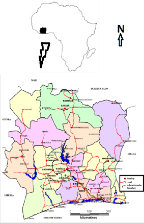
The study was realized in fifteen (15) localities spread over the territory of Côte d'Ivoire (Fig. 1) in the framework of the project financed by the Kreditanstalt für Wiederaufbau (KfW). Considering the multiplicity of areas to be covered and the geographical distribution of communities, the environmental conditions vary in space but also in time. For example, the geological and hydrogeological context varies from one area to another while climatic conditions change over time and inevitably have an impact on water resources. In the areas
IJSER © 2013 http://www.ijser.org
International Journal of Scientific & Engineering Research, Volume 4, Issue 7, July-2013 1964
ISSN 2229-5518
Fig. 1. Location of study areas all over the Ivorian country
2.2 Preliminary provisions
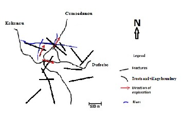
Morpho-structural study was conducted to determine the hydrogeological situation of each locality from aerial photographs or satellite images coupled with hydrographic and topographic maps at scale 1/50000 [6], [7]. Thus the main outlines are drawn on aerial photographs using a stereoscope (Fig. 2). Based on excerpts from topographic maps and hydrographic, the zone morphology is analyzed and determines the directions of geophysical exploration.
Fig. 2. Example of plot of main fractures and prospecting direction on Amoriakro area
On the ground, the fractures are expressed through their signatures marked as visible abnormalities in geomorphology: alignment of vegetation, termite alignment aboveground drainage, thalweg, fractures in outcrops, etc. [8]. These structures were identified using topographic maps at scale
1/50000, a compass and a Global Positioning System (GPS). This is a quick and inexpensive way to draw a structural or geological sketch, especially to identify fractures. It is a priori all alignments morpho-structural or lineaments highlighted by the hydrographic network or simply expressed by light or dark color in the photo. This technique also allows up fast and precise hydrographic network.
2.3 Measurement phase and choice of drilling sites
Before the intervention of the geophysicist, transects were realized in directions that could overlap with fractures. From this point, the installation of the device was guided to geophysics exploration by electrical methods. The apparent resistivity measurements were made. The data were processed and interpreted on site with the software Ipi2win installed on a laptop or with a semi-logarithmic diagram (Excel sheet or paper). Resistivity profiles are plotted and highlight anomalies in the basement. Geophysical methods applied are electrical dragged and electrical survey according to the approach of Schlumberger. The method of electrical dragged was used to delineate areas of anomalies corresponding to the presence of faults or fractures. The electrical dragged of the apparent resistivity reflect horizontal variability properties of the subsoil. They are used to monitor the lateral continuity of the
layers in a given position, and can confirm the presence or absence of anomalies [9]. The survey method was used to determine the thicknesses, the nature of the vertical structures and the depth of the anomaly beneath the measuring station. At each place explored, a site was retained for drilling, totaling three (3) sites per locality. Each selected site is identified by an alphabetical letter: A, B or C following the prospecting operations order.
2.4 Classification of sites and drilling order
At this stage, it is necessary to classify these three sites on the basis of their hydraulic potential, their accessibility and profitability in the project. The following criteria: hydrogeology, geophysics, accessibility, distance from the electrical power line. This classification is used to define the order of priority for drilling. The criterion "Hydrogeology" is appreciated on the basis of the mapping study, fracturing and geomorphology of the zone. The criterion "geophysics" is the appreciation of the values of apparent resistivity and the quality of the contrasts emerged on the resistivity profiles. The criterion of "accessibility" allows appreciating the practicality of ground to allow drilling machines to be installed on the site. The criterion "distance from the electrical power ligne" is an economic parameter involved in water supply projetcs. Indeed, the greater the distance between the drill and the power line, the greater the investment is huge for the electrical connection of drilling. It is therefore necessary to minimize this distance. However, both objective criteria that prevail in the classification are the hydrogeological context and the results of geophysical prospecting. The analysis of the different criteria allow to assign to each site, a number of stars varying from 1 to
3 (* or ** or ***) according to the assessment of the quality of the criterion studied. Three stars (***) are assigned when the parameter being evaluated is "very convincing." Two stars (**) are assigned when the parameter being evaluated is "pretty convincing." A single asterisk (*) is assigned when the measured parameter is "just okay." For the classification of the sites A, B and C, stars are added and the site which gets the highest number of stars is in the first position (Site of order 1). This site is a priority in the order of drilling. It is followed in second place by the most quoted site among the remaining two (Site of order 2). This is the site that is drilled if the first one is negative or does not provide the expected flow rate of drilling. If the first two sites don’t give satisfaction, the third one is drilled (Site of order 3). The criterion "geophysics" is based on the values of apparent resistivity. Resistivity profiles are plotted on semi-log graph and analyzed to identify the most favorable points.
3. RESULTS AND DISCUSSIONS
The data obtained from the hydrogeological and geophysical investigations have been compiled to highlight the classification of sites prioritized for drilling, taking into account the accessibility of drilling machines to selected sites (Table 1).
IJSER © 2013 http://www.ijser.org
International Journal of Scientific & Engineering Research, Volume 4, Issue 7, July-2013 1965
ISSN 2229-5518
Table 1: Number of stars gained according to the parameters studded and order of drilling
villages studied | Sites Hydrogeology Geophysics Distance to Quality of the way Drilling electricity line to the site order |
Amoriakro | A *** ** 900 Good 2 B ** *** 40 Good 1 C *** * 800 Tract to create on 300 meters 3 |
Bayota
A ** * 100 Good 3
B *** ** 1000 Good 1
C ** ** 200 Good 2
Binao-Boussoué

A *** * 800 Good 3
B ** ** 150 Good 2
C ** *** 500 Good 1
Bonoufla

A ** ** 300 Good 1
B ** ** 400 Good 2

C * * 600 Good 3
Bazré

A ** ** 400 Good 2
B * ** 100 Good 3
C ** ** 150 Good 1
Dignago
A ** * 200 Tract to create on 150 meters
B ** * 100 Good 2
C * ** 400 Good 1


A * ** 70 Good 3
Doropo
B *** * 1600 Tract to create on 250 meters

C ** ** 300 Good 1
Doukouya
A *** ** 250 Good 1
B ** ** 70 Good 3
C * *** 50 Good 2
Gadouan
A ** ** 500 Good 1
B ** ** 800 Good 2
C ** * 500 Good 3

Iroporia

Kononfla

A ** ** 800 Good 2
B * * 500 Good 3
C *** ** 300 Tract to create on 500 meters
Good
A ** *** 150 Good 1
B ** *** 200 Good 2

C ** ** 700 Good 3
Lataha
A ** *** 1000 Good 1
B * * 1200 Good 3
C ** * 500 Tract to create on 150 meters
Loviguié
A *** ** 150 Tract to create on 150 meters
B * ** 30 Good 3
C ** ** 450 Good 2


A ** ** 750 Good 2
Nambingué
B * ** 600 Tract to create on 250 meters

C ** ** 350 Good 1
Toumoukoro
A ** ** 70 Good 2
B ** *** 70 Good 1
C ** ** 600 Good 3
IJSER © 2013 http://www.ijser.org
International Journal of Scientific & Engineering Research, Volume 4, Issue 7, July-2013 1966
ISSN 2229-5518
Table 2 : Results and their explanation according to the flow and the order of drilling
Villages | Drilling Drilling flow rate Needs of populations order (m3/h) (m3/h) Analyze of drilling results |
Amoriakro | 2 not drilled The borehole 1 is successful and the drilling flow rate covers the 1 12.6 6 needs, so the other sites are not drilled 3 not drilled |

3 not drilled The borehole 1 gave an acceptable yield but it is not enough to cover
Bayota
1 7,96 19,4
2 18,9
the needs, so the site 2 was drilled. The assessment of survey data did not allow to quantify groundwater

3 1,13 The flow of drilling one does not cover the needs, so the sites 2 and 3
Binao- Boussoué
2 0,98 12,2
1 9,45
were drilled. But the drilling flow rates of those last boreholes are low. Therefore, the first borehole whose yield is better is allowed to be used while waiting for a over project of drilling.

1 11,63 Drilling 1 gave an acceptable drilling flow rate but it is not enough to
Bonoufla
2 37,8 17,5
3 not drilled
cover the needs, so the site 2 was drilled. The site ranked 2nd is best. The assessment of survey data did not allow to quantify groundwater

2 not drilled The borehole 1 is successful and the drilling flow rate covers the
Bazré
3 not drilled 9,1
1 44,5
needs, so the other sites are not drilled.

3 8,9 The yield of drilling one does not cover the needs. Drilling 2 was
Dignago
2 0,33 9,5
1 5,04
negative. It is the site ranked third that gave the best throughput. Data interpretation was not correct or there is failure in the measures.

3 not drilled The borehole 1 is successful and the drilling flow rate covers the
Doropo
2 not drilled 11,3
1 21,2
needs, so the other sites are not drilled

1 5,82 The yield of drilling one does not cover the needs. The Site 2 gave
Doukouya
3 not drilled 9,4
2 16,9
more than the expected rate. The interpretation of the data did not allow to quantify groundwater

1 13,75 Drilling 1 gave a yield of interest but not enough to cover the needs, so
Gadouan
2 16,8 26,7
3 not drilled
the site 2 was drilled. Here the need is enormous, so the drilling of two sites is required to achieve the goal. The difference between the two rates is minimal, but the choice of sites was well done.

2 2,6 Drilling 1 gave the best throughput. Polling sites 2 and 3 were given
Iroporia
3 4,72 10,5
1 10,8
smaller flows. The attempt to find a significant additional flow failed. Site 1 was selected even though the flow barely covers the needs

1 1,02 The flow of drilling 1 is small compared to the needs. This is the site 2
Kononfla
2 25,2 18,8
3 not drilled
which gave a good flow covering needs. The order of drilling was not correct

1 12,6 The borehole 1 is successful and the drilling flow rate covers the
Lataha
3 not drilled 6,5
2 not drilled
needs, so the other sites are not drilled

3 37,8 Site 1 was not available to the passage of the workshop in rainy
Loviguié
2 4,45 6,6
1 0,25
periods, sites 2 and 3 were first drilled, but rates have been insufficient. Site 1 was drilled in the dry season and gave ample flow. Data interpretation was correct

2 not drilled The borehole 1 is successful and the drilling flow rate covers the
Nambingué
3 not drilled 10,2

1 30,24
needs, so the other sites are not drilled
Toumoukoro
2 not drilled
1 12,6 6,5
3 not drilled
The borehole 1 is successful and the drilling flow rate covers the needs, so the other sites are not drilled
IJSER © 2013 http://www.ijser.org
International Journal of Scientific & Engineering Research, Volume 4, Issue 7, July-2013 1967
ISSN 2229-5518
3.1 Assessing the results of hydrogeological prospection
The study of fracturing allows appreciating the hydraulic potential of surveyed areas. More the area is fractured, more the interconnection of fractures is assertive and the chance to meet a productive fracture is highest [10].
Processing of aerial photographs has highlighted the characteristics of lineaments network. These are: the number, length, orientation and density of lineaments. Properties of the aquifer and the boreholes’ drilling flow rate in crystalline area depend on these parameters [11]. Previous studies have shown that fractures parallel to the direction of tectonic compressive stresses are open, while those that are orthogonal to tectonic stresses are closed [12], [13]. In fact, the direction NS (North- South) and his dispersions are parallel to constraints, so they are open. The direction NE (Northeast), or more precisely the orientation 40 ° N, corresponding to the birimian direction, is also considered as the direction of distortion.
In contrast, the orientation of fractures Northwest (NW), orthogonal to the constraints is tight. It is the same for trending fractures East-West (EW).
Therefore, fractures directions have a hydraulic quality questionable because some of them are opened and others are closed. Those that are open are susceptible to store water, so conducive to boreholes productivity, while those that are closed can’t ensure this hydrogeological role conferred upon them.
As a result, all fractures are not productive. The studies of Engalenc [12] showed that the frequency of fractures is a favorable factor in the storage reserves and transit flows, but the high frequency of a family of fractures is not necessarily a criterion of productivity. However, the fracture density influences the chances of success of drilling.
The geomorphologic analysis was used to assess the hydrogeological quality of the surface of the area prospected. Thus, the convergence zones of streams or trough are potential areas for infiltration of rainwater and groundwater supply [14].
When the slopes are softened, runoff has time to seep if the permeability of the ground permits. By cons, a steep slope is the site of rapid runoff that does not favor the retention of runoff water that accumulates in a short time at the outlet of the watershed [15].
The outlet is the gathering place for runoff and subsurface flow, so, it is often subject to flooding. The location of drilling site takes into account this aspect for the sustainable productivity of borehole.
In brief, the sites were sides taking into account the hydrogeological environment. The number of stars reflects the quality of hydrogeological conditions as follow:
One star (*): Slightly marked structure (site C of Bonoufla, site
B of Bazré, etc.).
Two stars (**): Fairly well marked structure (site B of
Amoriakro, Site A of Bayota, etc.).
Three stars (***): well marked Structure, priori favorable (Site of Amoriakro, site B of Bayota, etc.).
3.2 Assessment of the results of geophysical investigations
The analysis is focused on the values of apparent resistivity and contrasts observed through the resistivity profiles drawn
on semi-logarithmic diagram for both the electric dragged and the electrical survey.
The resistivity ρ of an area is the physical property that determines the ability of the environment to pass electricity [16]. On the profiles of electrical dragged, lower resistivities points are the places most electrical conductor. Geophysical exploration research is oriented on contrasts in the basement studied.
3.2.1. Case of electrical dragged
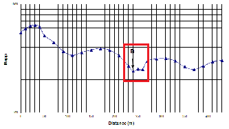
The shape of the anomaly highlighted on the resistivity profile is taken into account in the choice of the best temporary site on prospecting line (transect). Anomalies in U-shaped, V or H are the best because, from experience, drilling on this type of anomaly gave the best drilling flow rates (Figures 3, 4 and 5). The site B of Amoriakro was implemented on a contrast form looking like V and gave a significant drilling flow rate (12.6 m3/h). The site A of Bayota located on the fault type G produced a flow rate of 18 m3/h. Drilling performed on an abnormal form H of Konéfla also gave a high flow (25.2 m3/h). These results corroborate the study of Dieng et al [17] on the shape of the anomalies.
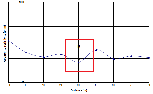
Fig. 3. Profile of apparent resistivities of Amoriakro electrical dragged: contrast form looking like V
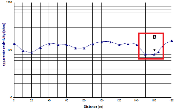
Fig. 4. Profile of apparent resistivities of Bayota electrical dragged: contrast form looking like U
IJSER © 2013 http://www.ijser.org
International Journal of Scientific & Engineering Research, Volume 4, Issue 7, July-2013 1968
ISSN 2229-5518
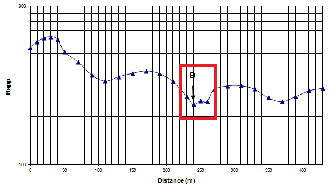
Fig. 5. Profile of apparent resistivities of Kononfla electrical dragged: contrast form looking like H
At the end of the prospecting phase, each file is analyzed and the definitive sites for drilling are adopted. A hierarchy is established between sites located to determine the drilling order. This order is based on the indices e
of apparent resistivity and appreciated Thus, it has been defined the following in One star (*) or Low geophysical index: th the presence of the anomaly is not clear; Two stars (**) or Medium geophysical i quite visible but does not express a specifi Three stars (***) or Strong geophysical i very clear and a specific form looking li through the profile.
3.2.2. Case of electrical sounding
Concerning the profiles of electrical sounding, the contrast observed on the resistivity profile reflects the presence of fractures at the corresponding depth. When the rise of a branch is dragging, it indicates the presence of important fractures in the depth (Figure 6 and 7). Therefore, there is resurgence of relatively lower resistivity at the crystalline basement which is very hard. More the trailing area is important on profile, more the fringe area of cracked area is greater [18].
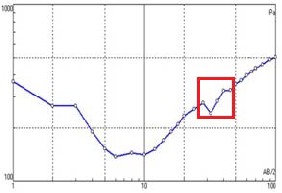
Fig. 6. Single contrast on the resistivity profile at Bayota
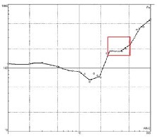
Fig. 7. Trailing contrast on the resistivity profile at Kononfla
ults of surveys and order
is rated at 3 stars for the nd 2 stars for the geophysical
+ 2 = 5). The B site totals 4 stars, geophysics. Site C has 3 stars in sics and totals 4 stars as Site B.
h has the largest number of stars order. The other two sites B and f points but priorities must be
identified and rank these two sites. Indeed, in terms of hydrogeology, site C has the best layout but geophysical measurements gave high resistivities and the contrast is not correctly perceived in bedrock to mark the presence of fractures. Thus, the site B which better expresses the anomaly in the basement is retained in second position in the drilling order.
In all localities, any site has perfectly fulfilled both hydrogeological and geophysical conditions. The maximum of points is 6 stars, but it is observed anywhere. By cons, there are several sites with low indices for all the scoring criteria. These sites are ranked in the last position (order 3) and can be probed if the first and the second site fail. This is the case of site C of Bonoufla, B of Iroporia and B of Lataha. This shows that all sites in position 3 do not have the same value in terms of drilling probability of success.
However, some sites are in position 1 in some places but have geophysical or hydrogeological characteristics similar to position 2 or 3 of other locations. For example, at Dignago, the maximum point obtained is 3 stars on each site, so the site C in position 1 has only 3 stars. Or 3 stars correspond to the 3rd position of Bayota, Gadouan, Bazré, and Gadouan Lataha. This means that the assessment and classification of sites depend on the environmental conditions of each locality [19].
When sites have the same number of points, priority is given to the site with easier access, away from sources of pollution such as cemetery, dumps, etc. (Sociological criterion) and closer to energy source (economic criterion). In addition, there
IJSER © 2013 http://www.ijser.org
International Journal of Scientific & Engineering Research, Volume 4, Issue 7, July-2013 1969
ISSN 2229-5518
are sites that require additional work such as access roads, backfill or leveling of land for the construction of civil works and installation of hydraulic equipment for the drilling operation if it is positive. It is obvious that this leads to additional costs that increase the project budget.
The issue of accessibility is taken into account because it is not enough to find the favorable site but it must be accessible to run the drill. Indeed, a too steep slope is not feasible for heavy equipment such as drills or straight trucks of equipment or water tanks in wet weather because the ground gets slippery.
3.4 Results and discussions of drilling strategy
The drilling campaign took place in all selected villages. The drilling order defined after the analysis of hydrogeological and geophysical data has been followed, exception of Loviguié because of the inaccessibility of the priority site in rainy weather. Through the analysis of the results in terms of wells productivity, it was possible to make the criticism of this drilling strategy (Table 2). A borehole is considered positive when it can cover the needs of the population or when it products a flow rate greater than 5 m3/h or equal. Considering the flow rate of 5 m3/h, the site ranked priority at Kononfla failed because the flow rate is 1.02 m3/h.
Taking into account the coverage of needs, sites respectively in position 1 at Bayota, Dignago, Bonoufla, Doukouya, Gadouan, Iroporia have not yielded the expected results. Therefore, a second or third hole was drilled for adding flow rates to meet the needs. This is the typical case of Gadouan and Bayota or needs are enormous because it is relatively large population centers.
Comparing flow rates, the sites listed in order 1 aren't necessarily the best. Some of them ranked in second order were superior to those of order one. This is the case of Bayota, Bonoufla, Kononfla and Gadouan. This means that the study did not quantify the groundwater even if it can locate it. However, on a total of 15 priority sites listed, 14 of them yielded a flow rate superior to the minimum allowable (≥ 5 m3/h), with 93% success rate. There are six localities (Amoriakro, Bazré, Doropo, Lataha, Nabimgué and Toumoukoro) where only one drill was enough to cover all the needs with flow rates ranging between 12.6 and 44.55 m3/h. In this case, other sites ranked in 2nd or 3rd position have not been drilled and it is economical for the project.
In total, there were 28 wells drilled with a success rate of 75% (Table 3). In fractured basement area, these high flow rates show that it is one of the best campaigns of drilling [20]. If it was a project of village boreholes with hand pumps, only three wells would be rejected for flow rate less than 1 m3/h.

Table 3: Summary of drilling results
Kononfla 2 1 1
Lataha 1 1 0
Loviguié 3 2 1
Nambingué 1 1 0
Toumoukoro 1 1 0
TOTAL 28 21 7
Pourcentage (%) 75 25

4. CONCLUSION
In this study of exploration, several parameters are involved and are, respectively scientific and economic. The study is based on scientific criteria. It is during the implementation that economic aspects are analyzed.
The present study, as conducted, was tested in numerous villages and the results obtained allow to judge the method used. In fact, the compilation of hydrogeological studies and geophysical investigations data allowed to groundwater prospecting on a multi-criteria analyze and scientific bases. Three sites were identified by location and they were classified in a priority order for the drilling phase. The choice of the best site requires a correct interpretation of apparent resistivities seen on the profile. It is necessary de get a good knowledge on the forms of the anomaly expressed on that profile. At the end of the drilling campaign, which followed the order predefined except for one village because of accessibility reasons, the results are conclusive. All localities were equipped with a borehole that can meet the needs of populations. On a total of
28 drillings, 21 were positive, 75% success rate on the basis of a qualifying 5 m3/h minimum flow rate. This success rate is related to the goal of meeting the needs of urban hydraulic systems that require high flow rates.
However, in practice, it is worth noting that the field of exploration of the hydrogeologist is sometimes limited due to sociological constraints such as cemeteries, sacred woods of Africa, etc. In addition, when drilling site is far from the electrical power line in the framework of a system which uses an electric pump, or when the drilling environment requires civil works (embankment, drainage rainwater, channels, etc.), the investment becomes more expensive. Thus, to take into account sociological and economic factors, the results of scientific investigations are somewhat skewed and it can have an impact on the results of the drilling campaign. In any case, it remains to develop new technologies to quantify groundwater in fractured basement aquifers. In geophysics, electrical methods which are the most used in the research of groundwater are not yet able to give a clear idea of the
Localities Number of boreholes
Number of positive boreholes
Number of negative boreholes
capacity of the aquifers explored, especially in fractured crystalline area. Therefore it is necessary to continue the
Amoriakro 1 1 0
research to improve the electrical Méthod of geophysics.
Bayota 2 2 0
Binao-Boussoué 3 1 2
Bonoufla 2 2 0
Bazré 1 1 0
Dignago 3 2 1
Doropo 1 1 0
Doukouya 2 2 0
Gadouan 2 2 0
Iroporia 3 1 2
IJSER © 2013 http://www.ijser.org
International Journal of Scientific & Engineering Research, Volume 4, Issue 7, July-2013 1970
ISSN 2229-5518
ACKNOWLEDGEMENT
We want to address our thanks to the Kreditanstalt für Wiederaufbau (KfW) for the financing of the project. We also thank the National office for drinking water and Gauff Ingenieure (Ingineering office) for their helping and collaboration without which this study would not have been possible.
REFERENCES
[1] Sree P.D., Srinivasulu S., Kesava K.R., 2001. Delineation of groundwater potential zones and electrical resistivity studies for groundwater exploration. Environmental Geology, Volume
40, Issue 10, pp. 1252-1264
[2] Sultan A.S., Hatem M.M., Fernando M.S., 2009. Groundwater exploration and appraisal by using geophysical interpretation (case study: Al Qantara East, North Western Sinai, Egypt). Arabian Journal of Geosciences, Volume 2, Issue
3, pp. 199-211
[3] Michael J.F., Oderson A.S.F., Fabio I., Adalene M.S., Sueli Y., 2012. Data-driven modeling for groundwater exploration in fractured crystalline field, Northeast Brazil. Hydrogeolgy Journal, Volume 20, Issue 6, pp. 1061-1080
[4] Tagini B., 1971. Structural Outline of Côte d'Ivoire, regional geotectonic test. Thesis, University of Lausan.
[5] Biemi J., 1992. Contribution of the geological, hydrogeological and remote sensing study subsahéliens watersheds of the Precambrian basement of West Africa: hydrostructurale, hydrodynamics, hydrochemistry and isotopic discontinuous aquifers furrows and granitic areas of high Marahoué (Côte d'Ivoire). State thesis in Natural Sciences, University of Abidjan, 424 p
[6] Ngo Y.A., Lasm T., Koïta M., and Savané I. Extraction of Remote Sensing of the major fracture networks in Precambrian basement area of Dimbokro (Centre of Côte d'Ivoire). Remote Sensing Journal, 2010, Vol. 9, No. 1, p. 33-42
[7] Youan Ta M., Lasm T. Jourda J.P., Kouamé K.F., Razack M. Mapping of geological features satellite imagery Landsat-7 etm
+ and analysis of fracture networks of Precambrian basement of Bondoukou region (north-east coast ivory). Remote Sensing Journal, 2008, Vol. 8, No. 2, p. 119-135.
[8] Koussoubé Y., Nakolendoussé S., and Savadogo A.N. The different signatures fractures in crystalline rocks of Sudano- Sahelian zone of Burkina Faso (watershed Bidi, Yatenga) . Remote Sensing, 2003, vol. 3, No. 5, p. 419-427
[9] Bakkali S., and Bouyalaoui J. Geophysical Prospecting applied to the evaluation of groundwater of Médiouna (Tangier, Morocco). Journal of Engineering Sciences, No.
4/2004, pp. 13-22
[10] Lasm T., 2000. Hydrogeology of fractured reservoirs of base: statistical analysis and geostatistics fracturing and hydraulic properties. Application to the Region of Hydrogeology Prospecting in Crystalline and Metamorphic Area by Spatial Analysis of Productivity Potential 390
Mountains Côte d'Ivoire (Domain Archean). PhD thesis, University of Poitiers, 272 p.
[11] Summers W.K., 1972. Specific Capacities of wells in crystalline rocks. Groundwater, Vol.10, No. 16, pp. 37-47
[12] Engalenc, 1981. Study and research of groundwater in crystalline rocks of West Africa, Volume 3 method. Atlas photo-interpretation. CIEH, Géohydraulique, 38 p.
[13] Savané I, Bénié G.B., Gwyn Q.J.H., and Biémi J. Application of remote sensing research of groundwater crystalline medium: Odienné, Côte d'Ivoire. Science news (as) AUPELF-UREF. Remote sensing of water resources. Proceedings of scientific conference in Tunis in 1993, pp. 111-
120
[14] Croke B.F.W., Islam A., Ghosh J., and Khan M.A., 2011. Evaluation of approaches for estimation of rainfall and the unit hydrograph. Hydrology Research volune 42 No. 5/2011, pp.
372-385
[15] Banton O. and Bangoy L.M., 1997. Hydrogeology, University Press of Quebec, Canada, 460 p.
[16] Chapellier D, 2000. Electrical Prospecting surface. Online course of geophysics - electrical resistivity. University of Lausanne, French Institute of Applied Geophysics, 102 p
[17] Dieng B., Kouassi A.H., and Bakyono B.A. Optimization of the geophysical location of drilling base area in northern Burkina Faso. South Science and Technology, No. 12 - June
2004, pp. 21-30
[18] Savadogo N.A, 1984. Geology and hydrogeology of the crystalline basement of the Upper Volta. Regional Study Watershed Sissili. PhD in Natural Sciences, Scientific and Medical University of Grenoble, 351 pages
[19] Savané I., 1997. Contribution to the geological and hydrogeological study of discontinuous aquifers Odienné crystalline basement (north-western Côte d'Ivoire). Contribution of Remote Sensing and hydrogeological information of spatial reference system . - State Thesis, University of Cocody, Abidjan, Côte d'Ivoire, 396 p.
[20] Kouadio K.E., 2005. Prospecting Strategy of groundwater by spatial analysis of potential productivity and optimize depth of drilling. Case of Denguélé region (Northwest of Ivory Coast). PhD Thesis, University of Cocody, Abidjan, Cote d'Ivoire, 181 p.
DETAILS ABOUT AUTHORS
Konan Emmanuel Kouadio : UFR des Sciences de la Terre et des Ressources Minières, Université Félix Houphouet Boigny, Abidjan, B.P. 582, Abidjan 22, Côte d’Ivoire ; Email : emmakouadio@hotmail.com; Tel : +225 47 24 46 11
Arthur Brice Konan-Waidhet : UFR des Sciences et Gestion de l’Environnement, Université Jean Lorougnon Guédé, Daloa; B.P.V. 1501, Daloa, Côte d’Ivoire ; Email : konanwab@yahoo.fr
Kouadio Koffi : UFR des Sciences et Gestion de l’Environnement, Université Nangui Abrogoua, Abidjan; B.P.
801, Abidjan 02, Côte d’Ivoire ; Email : kouadiok1@yahoo.fr
IJSER © 2013 http://www.ijser.org