International Journal of Scientific & Engineering Research, Volume 4, Issue 11, November-2013 39
ISSN 2229-5518
Geothermal gradient of the Niger Delta from recent studies
1Adedapo Jepson Olumide ,2 Kurowksa Ewa, 3 Schoenick. K, 3 Ikpokonte. A. Enoch
ABSTRACT
In this paper, s ubs urf ac e temp erature meas ured from c ontinuou s temperature logs were us ed to determine the geothermal gradient of NigerDelta s edimentar y basin. The meas ured temp eratures were c orrec ted to the true s ubs urf ac e temperatures by applying the Americ an Association of Petroleum Res ourc es (AAPG) c orrec tion f actor, borehol e temperature c orrec tion f actor with La Max’s c orrec tion f actor and Zeta Utilities boreh ole c orrection f ac tor. Geothermal gradient in this bas in ranges from 1.20C to 7.560C/100m. Six geothermal an om alies
c entres were obs erved at depth in the s outhern parts of the Abakaliki anticlinorium around Onits ha, Ihial a, Umuaha area and named A1 to A6 while two m ore c entre appeared at depth of 3500m and 4000m named A7 and A8 res pectively. Anom aly A1 desc ribes the s outhern end of the Abak aliki anticlinorium and extends s outhwards , Anomal y A2 to A5 were f ound ass ociated with a NW -SE struc tural alignment of the Cal abar hinge line with s tructures desc ribing the edge of the Niger Delta bas in with the bas ement bloc k of the Oban massif. Anom al y A6 loc ates in
the s outh-eas tern part of the bas in offshore while A7 and A8 are loc ated in the s outh wes tern part of the basin offs hore. At the average explorator y depth of 3500m, the geothermal gradient values f or thes e an omali es A1, A2 A3 A4 A5 A6 A7 A8 are 6.50C/100m, 1.750C/100m,
7.50C/100m,1.250C/100m,6.50C/100m,5.50C/100m,60C/100m and 2.250C/100m res pec tively. Anomal y A8 area may yield higher thermal value at greater depth than 3500m. Thes e res ults show that anom alies areas of A1, A3, A5, A6 and A7 are pot entially pros pective and explor able
for geothermal energy using ab andon ed oil wells in the study area. Anomalies A1, A3.A5, A6 occ ur at areas where drilled boreholes were
not expl oitable f or oil and gas but f or the remaining areas where wells are s o exploitable there appears no geoth ermal anom aly. Geothermal energy is environm entally f riendly, clean and revers ible.
Key words: Continuous temperature logs, geothermal gradient, geothermal anomalies, Niger Delta and sediments.
.
The geothermal gradient is the rate at which the earth’s temperature increases with depth. This implies that heat is flowing from the hot earth’s interior to the surface. The earth’s heat is believed to have being derived from the decay of radioactive elements, impact and compression of the earth in the release of meteorites, heat released from the electromagnetic effects of the earth’s magnetic field and heat released during tidal force on the earth as it spins along its axis and rotates since the land cannot flow like water, it compresses and distorts thereby generates heat. There are variations in geothermal gradient from place to place. It is determined from the measurement of temperature of rocks penetrated by borehole after drilling when the drilling fluids have reached the ambient temperature but this is not always achievable for practical reasons.
————————————————
• 1Adedapo Jepson Olumide is currently a lecturer with Mineral Resources Engineering Department, Federal Polytechnic, Ado-Ekiti. Nigeria. E-mail address: olujepson@gmail.com
• 2Kurowksa Ewa is currently a Senior lecturer University of Silesia.
• 3Schoenick. K and Ikpokonte. A. Enoch are currently a Professor and a
Reader at Geology Department. Ahmadu Bello University, Zaria. Nigeria respectively.
The knowledge of the geothermal gradient of a place helps in determining the suitability of such places for siting geothermal plants for the generation of electricity that can be utilize for industrial, domestic and recreational activities and the predictions of zones that can house petroleum/crude oil and in the design of deep wells, cementing programs, oil and gas evolution history (Kerogen) as in hydrocarbon generation, migration and organic maturity.
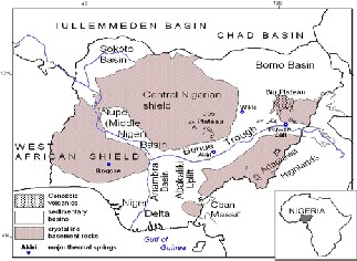
The major sedimentary basins in Nigeria are shown in Figure 1. They are: Niger delta about 12 km deep, Anambra Basin, Lower Benue Trough and Middle Benue Trough which are about 7 and 5 km of depth, Upper Benue Trough only about 3 km to the crystalline rocks, Nupe Basin about
1.2 km, Sokoto Basin(Part of Illumeden Basin) about 1.5 km, Chad Basin 7 km deep and finally Dahomey Basin, about 3 km maximum of depth. The depth is important for geothermal exploration. Theoretically, higher geothermal gradients are expected in deeper basins, lower in shallower basins [18]. There are however exceptions from this rule: The highest geothermal anomalies were discovered by [31], in the relatively shallow Sokoto Basin, while the lowest geothermal gradients in Nigeria were recorded by [21], in the deepest Nigerian basin, that is in the Niger Delta.
Few authors have worked on the geothermal gradient of Nigeria’s sedimentary basins. Historically, quest for geothermal energy in Nigeria starts with report on hot water flowing from artesian wells drilled in Chad Basin, published in 1965 by two hydrogeologists, [8]. Then, [21],
IJSER © 2013 http://www.ijser.org
International Journal of Scientific & Engineering Research, Volume 4, Issue 11, November-2013 40
ISSN 2229-5518
calculated the geothermal gradients in Niger Delta sedimentary basin from 1000 oil-well logs and reported that regional geothermal gradients range between 0.7 – 1.00F /
100ft over the centre of the delta and then increase towards northwards and seaward to a maximum value of 2.7 to
3.00F/100ft. He discovered an inverse relationship between the geothermal gradient and depth to basement. Also he recommended that part of the basin is undrilled, therefore there is need to extend drilling below the present 2500m depths of exploration.
The third step in geothermal exploration of Nigeria was made by [3], investigated the geothermal conditions of the Chad Basin by analysis of thermal information from 64 shallow boreholes drilled for water supply and deduced that the geothermal gradient of this Basin is between 2.70C to 50C/100m. In the same year [29] at the international conference on Chad Basin held in N”djamena Chad Republic presented geothermal maps of Chad Basin from results of temperature measurements in water from 27 wells. The geothermal anomalies on the presented geothermal maps shows cool anomalous zone ~ 2- 30C/100 m and warm anomalous zone~ 6.40C/100m. Three years later, in 1990, for the same Nigerian part of the Chad Basin, [23] using temperature data of 12 oil wells calculated a geothermal range of 2.160C to 5.260C.
Then, in 1989, [31] presented to the Department of Geology Ahmadu Bello University his master’s thesis on geothermal gradient in Sokoto Basin. Using temperature data from boreholes drilled for water supply he was able to locate a long narrow positive geothermal anomaly up to 100C/100m on the background of 30/100m.
In 1999, [26] worked on data from 16 deep wells in respect of subsurface temperature variations and heat flow in the Anambra Basin and published that there are large variations in temperature gradients and heat flow within the basin. The geothermal gradients vary between 25 and
49 ± 1°C km−1, while heat flow estimates are in the range 48 to 76 ± 3 mW m−2. The highest geothermal gradients and heat flow values were computed for the wells located in the southwestern part of the basin north of Onitsha and Asaba. This part of the basin coincides with zones of thick, low conductivity sediments, low ground surface elevation, and hydraulic discharge zones. Their results do not support the general direction of increase in geothermal gradient, originally projected as south to north by earlier workers dealing with the Niger Delta data and, perhaps because of the very limited well data from the Anambra Basin, is inconsistent with the results of the present study.
Recently, in 2009, [22] deduced from the work on the geothermal gradient in the Chad Basin. Nigeria from logs of boreholes drilled for oil that the thermal gradient for Chad Basin ranges between 3.0 to 4.4 0C/100m with an average of 3.40C/100m and that the obtained gradient values are lower than the adjoining Benue Trough, Anambra Basin and Niger Delta. This difference they attributed to high tectonic activity in Chad Basin and the basin is considered unstable. However the geothermal gradient in this basin is highest at the centre and lowest in
the northeast and southeast part of the basin. The relatively high geothermal gradient in the central part of the Chad Basin which is the Nigerian section indicates high thermal conductivity resulting in the conversion of oil to gaseous forms therefore the other areas should be the target for oil exploration
Unpublished document kindly availed by [6], on his work on the Geothermal Energy Potential of the part of Middle Benue Trough in Nassarawa State using information obtained from the temperature measurements in 150 boreholes drilled for water supply and some thermal springs (Akira, Ribi, Azara, Keana and Awe) discovered several geothermal anomalies up to 70C/100m on the background of 30C/100m.
The other aspect of geothermal exploration in Nigeria is investigating the surface geothermal manifestations in form of the thermal springs and seepages, which occur mainly within sediments of the Middle and Upper Benue Trough. Akiri and Ruwan Zafi the water of the warmest springs in that area, described by [6] have temperature about 54°C. This may suggests the existence there of some, not yet known, geothermal anomalies.
It is important to state that the last research work on the geothermal gradient of the whole Niger Delta sedimentary basin took place about forty years ago, hence the researcher opined that there might be new discovery in terms of geothermal anomaly in these areas because of the following reasons:-Increase in drilling activities which implies more temperature data, greater drilling depths and improved prospecting and exploration technology which allows accessibility of inaccessible areas three decades ago.
This paper presents the results of the analysis of more geothermal data for alternative energy resource of the Niger Delta where oil and gas extraction extensively practiced now may exhaust in the year 2040.
Geothermal power plants require no fuel (except for pumps) and are therefore immune to fuel cost fluctuations. Drilling accounts for over half the cost and exploration for deep resources entails significant risks with about 20% failure rate. The plant has minimum land and freshwater requirements. Geothermal plants use 3.5 km2 (1.4 sq. ml) per gig watts of electrical production compared to 32 and
14 km2 for wind and coal respectively.
Geothermal energy is used in space heating, agriculture
and animal husbandry and electric power generation.
The Niger delta basin is situated on the continental margin of the Gulf of Guinea in equatorial West Africa between latitudes 30 and 60 N and longitudes 50 and 80 Et. It ranks amongst the world’s most prolific petroleum producing Tertiary deltas that together account for about 5% of the world’s oil and gas reserves and for about 2.5% of the present – day basin areas on earth. It is one of the world’s largest deltas covering an area of 75,000 km2 with a fill of about 12,000 m classic sediments. (Figures 1 & 2) It is one of the prominent basins in West Africa and actually the largest delta in Africa.(Reijers ,1996) The Niger delta area covers Abia, Akwa Ibom, Bayelsa, Cross River, Delta, Edo, Ondo,
IJSER © 2013 http://www.ijser.org
International Journal of Scientific & Engineering Research, Volume 4, Issue 11, November-2013 41
ISSN 2229-5518
Ebonyi , and Rivers states of Nigeria. The areas are easily accessible by good road networks.
There are a large number of academic publications concerning the general geology of the Niger Delta but few on the underground temperature distributions. Notably among the past are [34],[16],[28].
[34] described the Niger Delta as a large, arcuate delta of the destructive wave dominated type. A sequence of under compacted marine clays overlain by parrallic deposits in turn covered by continental sands is present throughout, built up by the imbricated superposition of numerous offlap cycles. Basement faulting affected delta development and thus sediment thickness distribution. In the parrallic interval growth faults with associated rollover structures traps hydrocarbons. Faults in general play an important role in the hydrocarbon distribution. Growth faults may even function as hydrocarbon migration path from the overpressured marine clays. Depositional environments of reservoir sands strongly influenced well productivity as well as recovery efficiency.
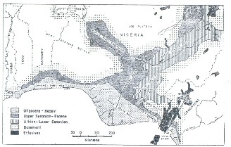
[12] described the Tertiary sediments of the Niger Delta basin as deposits in three major sequences. The oldest sequence, the Akata Formation consists of the holomarine shale which ranges in age from Oligocene to Recent and is assumed to be the main active source rock in the basin. This unit is overlaid by the dominant Eocene to Pleistocene – aged marine sand-shale sequence of the Agbada Formation. The youngest sequence is the Benin Formation consisting of upper coastal plain sands and a massive continental sequence. Growth faults and roll over structures are the common trapping mechanism for hydrocarbon accumulation in the Niger Delta complex. Most oil fields are associated with these features. (Figures 2 & 3.)
The research methodology was analytical and descriptive. The temperature (primary data) were borehole data sourced from the Department of Petroleum Resources, Lagos and geophysical data from Shell Petroleum Development Company, an oil company operating in the area of interest with secondary information obtained from review of temperature distributions in this area. The temperature data were subjected to corrections, analysis and interpretation.
Temperature log of six hundred wells were acquired from the Department of Petroleum Resources, Lagos an arm of Nigerian National Petroleum Corporation.(NNPC) The data were received in form of pdf file. In addition a Nigerian block map containing the names and location of all the wells has been acquired form Department of Petroleum Resources, Lagos. The map was received as computer – PDF file.
By assuming a linear relationship of temperature and depth, the geothermal gradient was calculated. The results were presented in form of a table and used to plot the gradient map as well as some statistical analysis i.e the mean, median and mode of the obtained geothermal gradient. Since geothermal gradients are calculated on the
assumption of a linear increase of temperature with depth, the temperature and depth relationship can be specified as follows:
Geo gradient OC/100m =
Corrected Temperature OC – Surface Temperature tOC χ 100
Depth (m)
The corrected temperatures of the deep rock mass used for this research work were obtained by using three correction methods. They are: 1) American Association of Petroleum Geologist (AAPG) correction factor. GoM Waples et.al. (2004) correction factor, Zeta utilities borehole correction factor.
Manual preparation of a base map with geothermal gradient map of the Niger Delta ensued after the calculation of the geothermal gradients for each oil well. Thereafter the maps were prepared with the use of Geographic Information Systems (GIS) software’s /tools viz., MapInfo, Global Mapper and Surfer. Results and Discussions.
Temperature data was used for plotting map of geothermal gradient (Figure 4). The geothermal cross sections were also produced Figures 5 & 6
In this research work, the highest geothermal values were recorded very close to the Cretaceous rocks outcropping in the North of Niger Delta while the minimum geothermal gradient obtained across the sedimentary basin is
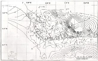
1.2OC/100m which is found at the central part of the basin. The maximum value is 7.62 OC/100m obtained at the north eastern part of the basin very close to Abakaliki anticlinorium, Oban massif and Afikpo syncline. The mean geothermal value is 3.29OC/100m; median is 2.53OC and Range 6.62OC/100m. The result obtained from this work is in conformity with [21] work which deduced from his work on Approximate geothermal gradient in Niger Delta sedimentary basin that the gradients are lowest at the centre of the delta and increase northward and southward. He opined that these differences and high geothermal range value suggest that the rates at which various wells attain equilibrium may be caused by such factors as differences in borehole diameter and thermal conductivity of rocks. The geothermal minimum of this sedimentary basin coincides with the location of the gravity minimum. Hospers, 1965 deduced from his work that this area coincides with the area of the basin where there is maximum thickness of sediments.(figure 5 and 6) The geothermal range conforms to the range found in tectonically inactive areas [21]
It was deduced from the geothermal map (figure 3) the geothermal gradient is highest at the north eastern part of the basin and quite high at the south eastern part of the sedimentary basin offshore. The geothermal gradient map is also useful as an exploration tool in the oil industry [21] Anomaly describes an edge of a structure. In this study, they are curvi linear in arrangement depicting /defining a structural edge. The structural edges are at the north eastern, south western and south eastern part of the basin. The structural edges are defined by a fault that could be referred to as Calabar Hinge line or eastern limit of the
IJSER © 2013 http://www.ijser.org
International Journal of Scientific & Engineering Research, Volume 4, Issue 11, November-2013 42
ISSN 2229-5518
basin with the basement of the Oban Massif.
The Aba/Umahia geothermal anomaly is interpreted from
five boreholes ( Ikpe 1,Ngwa 1,Ikono 1,Ika 1,Ikana south 1
and Ibesit 1 ) in which the rock temperature at their bottom
ranged from 180C to 2170C and their gradient ranges from
6.14/100m to 7.62/100m while the geothermal anomaly is
located within the Uyo/Iket oil field.
The geothermal anomalies are named A1, A2, A3, A4, A5,
A6, A7 and A8. The shapes of the anomalies are either
rounded or ellipsoidal. (Figure 4)
A1 anomaly lies North West of the cross river structural
trend with the Calabar hinge line. It is close to the
Onitsha/Ihiala area which is the structural end of Abakaliki
anticlinorium and Afikpo syncline. The rock bottom
temperature ranges from 179.630C to 188.60C and
geothermal gradient is high 6.50C/100m in Nsukwa oil field
FF1 the structural trend describes the Okitipupa hinge line as a step faulted margin of the basin with the south western Basement Complex. It does not define a high geothermal anomaly; however, oil show at Okitipupa would prove to
be energy alternative as different from the eastern edge where there is no oil but has geothermal energy indication. Araromi west and Benin west 1 are the extreme wells towards North West and they show a shallow basement and a faulted structures. The extension of anomaly could be found in A1. [26] worked on data from sixteen deep oil wells in respect of temperature variations and heat flow in the Anambra Basin. In their work the highest geothermal gradient and heat flow value were computed from wells located in the southern part of the basin north of Onisha and Asaba and these zones coincides with the zones of shallow depths. Their result is consistent with the result of the present study.
In cross section BB1, the anomaly is shown at the southeastern part of the Basin; high anomaly is obtained at Amojie 1 and Ikpe 1 boreholes from shallow depth.
It is noted that the high geothermal anomalies occur in areas where boreholes are not producing oil and gas but for the remaining areas where oil wells are producing there is no anomaly and temperature gradient is minimal. Anomalies at depths ranging from 500m to 3000m are named A1 to A6 while the two remaining anomalies appear at depth above 3000m A1 is located in the southeastern end of the Abakaliki anticlinorium around Onisha/Ihiala. Umahia areas and extends southerly. Anomalies A2 to A5 are found associated with structural alignment of Calabar hinge line, a structure here describing the eastern edge of the Niger delta basin with the basement block of the Oban massif. Anomaly A6 is located in the southeastern part of the basin offshore while anomalies A7 and A8 locate at the south western part of the basin offshore. At a depth 3500m and above A7 disappears probably because at that depth the temperature is not hosted in the rock while A8 appears this implies that with further investigation of greater depths more anomalies will be discovered while some may disappears. A2 and A4 are negative geothermal potential directly opposite anomalies A3 and A5. The findings from the Nigerian block map indicated that oil wells close to A2
and A4 are probably producing oil wells while oil wells that are of close proximity to A3 and A5 are likely non- productive. At the average exploratory depth of 3500m, the geothermal gradient values for these anomalies A1, A2 A3
A4 A5 A6 A7 A8 are
6.50C/100m,1.750C/100m,7.50C/100m,1.250C/100m,6.50C/1
00m, 5.50C/100m,60C/100m and 2.250C/100m respectively
In this work, the recorded geothermal gradient is low in
Warri and Port Harcourt areas (central part of the Niger
Delta Basin). However pockets of high geothermal gradient
values are recorded in the northeastern part of Niger Delta
specifically at Ibesi and Adofi where there is elongated hot
anomaly probably unknown due to fracture below. This
indicates enormous/ great energy potential that can be
extracted for various purposes. Energy exploitation will be
optimal if sited around the northern and southern parts of
the basin. At the offshore 6.2OC is recorded at Ikano, southern part of the Basin. A geothermal fracture trending NW/SE is recorded at Aba/Umahia axis. However it was observed from the results of this work that the regional low
thermal gradients correspond with the large areas of subsidence beneath the deep Delta Basin mostly onshore and near shore.
The result obtained indicated that the geothermal gradient of Niger Delta increases from the central part of the Delta outwards towards the northeastern and the southeastern parts of the Basin with the background geothermal gradient value of 2.53OC/100m. It was also observed that the regional geothermal relationship is non-linear but variable indicating a drastic change in gross lithology. The centre of the basin where there is exploitation activities is not indicating high geothermal gradient possibly because energy preserved is form of hydrocarbons from there while the high geothermal gradient areas are not indicating much occurrences. The geothermal anomalous areas could possess great heat which is the alternative reservation of energy in the study area.
Minimum geothermal gradient value of 1.2OC/100m is found at the central part of the basin while maximum value is 7.62 OC/100m obtained at the north eastern part of the basin very close to southern part of the Abakaliki anticlinorium and western part of the Oban massif and Afikpo syncline. The mean geothermal value is
3.29OC/100m; median is 2.53OC and Range 6.62OC/100m. The following conclusions can be derived from the present study.
1. The gradient range from 1.2OC/100m to
7.62 OC/100m in the study area while the
mean value is 3.29OC/100m. The lowest
geothermal gradient is recorded at the centre
of the basin and increases southward,
northward and southeastward to a maximum value of 6.50C/100m,7.620C/100m and
5.50C/100m respectively.
2. Deductions from the drawn geothermal,
geological cross-sections and maps are in good
agreement.
IJSER © 2013 http://www.ijser.org
International Journal of Scientific & Engineering Research, Volume 4, Issue 11, November-2013 43
ISSN 2229-5518
3. Areas of low geothermal gradient are mostly areas where the oil wells are prolific.
4. Areas of high geothermal gradient are areas of gas wells .The oil must have been converted to gas because of the high temperature or energy preserved as heat
5. There are high gradients in the western offshore and eastern flanks of the Niger Delta to about 5.50C/100m and areas of lowest temperature gradients occur at the nose of the Niger Delta basin and coincide with areas of maximum sediment thickness.
Also in this work three positive geothermal anomalies
60C/100m, 6.50C/100m and 7.620C/100m not known to the
past workers were discovered onshore over the
background of 2.50C/100m. To these two anomalies the
names Adofi and Ibesit anomalies respectively are herewith given. Two positive geothermal anomalies ware discovered offshore with a peak of 60C/100m and
6.860C/100m to which the names Ikano and Obianga
anomalies are given.
[1]. Ako,B.D., Ojo,S.B., Okereke,C.S., Fieberg, F.C., Ajayi,T.R.., Adepelumi.A.A.,Afolayan, J.F., Afolabi.O and Ogunnnusi,H.O., (2004): Some Observations From Gravity/Magnetic Interpretation Of The Niger Delta.. NAPE Bulletin, Vol 17/1:1-21.
[2] Ajibade.C. A., Woakes.M, Rahaman.M.A(1989):- Proterozoic Crustal Development In Pan-African Regime of Nigeria. In: Kogbe .C.A (ed). Geology of Nigeria. 2nd Revised Edition. Abiprint & Pak Ltd. Ibadan.
[3]Askira. M. T. (1987): Geopresured Aquifers And Geothermal Gradient In Borno State. Nigeria. Unpublished Masters of Science Thesis, submitted to the Department of Geology, Ahmadu Bello University, Zaria.
[4]Avbovbo, A.A, 1978; Tertiary Lithostratigraphy Of Niger
Delta. American Association of Petroleum Geologist. Bulletin
62,295-300.
[5]Avbovbo.A.A, 1978; Geothermal Gradients In The
Southern Nigerian Basins. Bulletin of Canada Pet
Geology,(26)2. 268-274.
[6]Bako. A. J. (2010): Geothermal Energy Potential In The
Part Of Middle Benue Trough located In Nassarawa State. Unpublished M.Sc. thesis, submitted to the Department of Geology, Ahmadu Bello University, Zaria.
[7] Barber W. (1965): Pressure Water In The Chad Formation Of Borno And Dikwa Emirates, Northern Nigeria. Geological Survey of Nigeria Bulletin. Vol 70. No12.
[8] Barber. W and D. G. Jones (1960): The Geology and
Hydrology of Maiduguri, Borno State. Unpublished records of
the Geological Survey of Nigeria. Kaduna.
[9] Burke, K. 1972; Longshore Drift, Submarine Canyons,
And Submarine Fans In Development Of Niger Delta.
American Association of Petroleum Geologists 56, 1975-1983.
[10] Carter, R. C., and A. B. Alhassan, (1998):-
Groundwater, Soils And Development In The Oases Of The
Manga Grasslands, Northeast Nigeria: In Hydrology in a
Changing Environment, Leeds: Wheater, H and C. Kirby
(ed): Proceedings of the British Hydrological Society, Exerter, pp 205-211.
[11] Doust, H., Omatsola, E. 1990; Niger Delta. In: Edwards, J.D., Santogrossi, P.A.(Eds), Divergent/Passive Margins Basins, Vol 4. American Association of Petroleum Geologists Memoir, pp. 2239-248.
[12]Dublin-Green.W.F and Agha.G.U (2005): Future Petroleum Potential Of Nigeria. Document sponsored/printed by NNPC/Mobil.
[13] Jubril M. A, Shaw H. F and Fallick A. E (1998); Stable Isotope And Geochemical Evidence Of Formation Pore Fluid Evolution During Diagenesis Of Tertiary Sandstones And Mudstones Of The Niger Delta. Journal of African Earth Sciences, Vol. 27, Nos 3 and 4, pp. 417-435, 1998, Elsevier Science Ltd.
[14] Jubril M. A and Amajor L. C.(1991); The Afam Clay Member; A Lower Miocene Incised Channel In The South- Eastern Niger Delta. Marine Petroleum Geology. Vol. 8., pp.
163-173.
[15]Knox, G. J. Omatsola, E. M., (1989); Development Of
The Cenozoic Niger Delta In Terms Of The “Escalator
Regression” Model And Impact on Hydrocarbon
Distribution. In; van der Linden, W.J.M.
[16] Kogbe C.A. (1989): Geology of Nigeria. 2nd revised
edition. Rock View (Nigeria) Press. Jos. Pp 257-275, pp 325-
334.
[17]Kulke,H.,( 1995); Nigeria. In: Kulke, H.(Ed), Regional
Petroleum Geology Of The World, Part II: Africa, America,
Australia and Antarctica. Gebru Borntraeger, Berlin, pp 143-
172.
[18] Kurowska,E. and Schoeneich.K (2010): Geothermal
Exploration In Nigeria. Proceedings of World Geothermal
Congress, 2010. Bali, Indonesia, 25-29 April 2010.
[19]Millegan, P.S and D.E Bird.(1998): ‘’How Basement
Lithology Changes Affect Magnetic Interpretation : In
Geologic applications of Gravity and Magnetic: Case
Histories’’(Eds. Gibson, I. and Millengan, P.S)(SEG Geophysical Reference No 8 and AAPG studies in Geology, No 43. Tusla 1998)pp40-44.
[20]Murrat .R.C (1970): Stratigraphy and Palaeogeography Of The Cretaceous And Lower Tertiary In Southern Nigeria. In African Geology. University of Ibadan Press Dec
IJSER © 2013 http://www.ijser.org
International Journal of Scientific & Engineering Research, Volume 4, Issue 11, November-2013 44
ISSN 2229-5518
1970 .pp251-266
[21] Nwachukwu, S.O. (1976): Approximate Geothermal
Gradients In The Niger Delta Sedimentary Basins. The
American Association of Petroleum Geology. Bulletin. vol 60,
No 7, pp 1073-1077.
[22] Nwankwo.C.N and S.A. Ekine (2009): Geothermal
gradients in the Chad Basin, Nigeria from bottom hole
temperature logs. International Journal of Physical Sciences,
Vol 4 (12), Pp 777-783.
[23] Nwazeagwu A. U. (1990): Hydrocarbon Exploration In
Frontier Basin. The Nigeria Chad Basin Experience.
proceedings of the 26th Annual Conference of the Nigerian
Mining and Geosciences Society. Port Harcourt.
[24]Obaje, NG; Wehner, H; Scheeder, G; Abubakar, MB;
Jauro, A (2004). Hydrocarbon Prospectivity Of Nigeria’s
Inland Basins: From The Viewpoint Of Organic
Geochemistry And Organic Petrology. AAPG Buletin, 88, 3,
325-353.
[25]Ochuko.A (2011); Determination Of Geothermal
Gradient And Heat Flow Distribution In Delta State,
Nigeria. Intern. Journa. of the Physical Science. Vol. 6 (31)pp
7106-7111.
[26]Onuoha K.M, (1999): Structural Features Of Nigeria’s
Coastal Margin: An Assessment Based On Age Data From
Wells. Journal of Earth Sciences, Vol 29, No 3, pp485-499.
[27]Powell, D.W., (1965):’’ A Rapid Method Of Determining
Dip or Magnetization Inclination From Magnetic
Anomalies Due To Dyke –Like Bodies’’. Geophysical
prospecting. 13(1): 4p
[28] Reijers T.J.A. (1996): Selected Chapters On Geology:
Sedimentary Geology And Sequence Stratigraphy In
Nigeria, Three Case Studies And A Field Guide. Shell
Petroleum Development Corporation. Corporate Reprographic
Services. Warri.
[29] Schoeneich. K. and M. T. Askira (1987): Preliminary
Geothermal Outline Of The Nigerian Part Of The Chad
Basin. International Seminar on Water Resources of the Lake
Chad Basin held at Njamena, Chad Republic, from 3rd to 5 June
1987.
[30] Short, K. C., Stauble, A. J. (1967); Outline Of Geology Of Niger Delta. American Association of Petroleum Geologists Bulletin 51, pp. 761-779.
[31] Solomon A. O (1989): Geothermal Gradient And Temperature Of Groundwater In The Sokoto Basin. Sokoto State. Nigeria. Unpublished M.Sc thesis Ahmadu Bello University. Zaria.
[32] United Nations Development Programme (UNDP) (2007): Niger Delta Human Development Report.
[33] United Nations Development Programme (UNDP) (2010): Contribution Of Energy Services To The Millennium Development Goals And To Poverty Alleviation In Latin America And The Caribbean, ECLAC Project Documents
Collection.
[34]Weber K.J., and E. Darkoru (1971): Petroleum Geology
Of The Niger Delta. Geologie en mijnbouw. Vol50(3) pp 559-
576.
[35] Weber. K. J., Daukoru, E. M., (1975); Petroleum
Geology Of The Niger Delta , In: Proceedings of the Ninth
World Petroleum Congress, Geology. Vol 2. Applied Science
Publishers Limited. London, pp. 210-221
[36] Waples, Douglas W., Pacheco. J and Vera. A. (2004);A
Method For Correcting Log-Derived Temperatures In Deep
Wells, Calibrated In The Gulf Of Mexico,
Petroleum.Geosciences,Vol10.Pp39-
245. http://zetaware.com/utilities/bht/waples_gom.htm
1. Waples, D.W. and Ramly Mahadir. (2001); A
statistical method for correcting log-derived
temperatures. Petroleum Geoscience. Vol 7. Pp
231-
240. http://zetaware.com/utilities/bht/waples_g
om.htm
2. Whiteman,A.1982; Nigeria: Its Petroleum
3. ZetaWare Utilities- Borehole Temperature
IJSER © 2013 http://www.ijser.org
International Journal of Scientific & Engineering Research, Volume 4, Issue 11, November-2013 45
ISSN 2229-5518
Figure 2: Geological sketch map of Niger Delta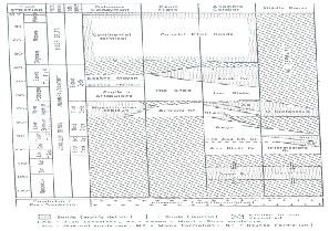
Figure 4: Geothermal gradient map of Niger Delta Basin. Explanation 1. ʘ Borehole locations with temperature data used for the construction of this map. 2. Isograds
in 0C/100m and
4. Geological cross section lines shown in figures 16 and 17.
5. A1-A8 are geothermal anomalous areas.
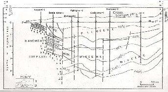
Figure 5: Northwest –Southeast section across line FF1. Explanation: 1 Isograds in 0C/100m. 2. Isothermal in 0C Source of the geological cross section is from Onuoha.K.M
1999.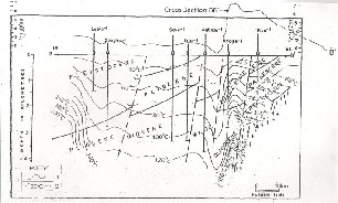
Figure 6: Southwest –Northeast section across line BB1. Explanation: 1 Isograds in 0C/100m. 2. Isothermal in 0C Source of the geological cross section is from Onuoha.K.M
1999.
IJSER © 2013 http://www.ijser.org