
International Journal of Scientific & Engineering Research, Volume 2, Issue 11, November-2011 1
ISSN 2229-5518
Geographic Information System (GIS) – for
Business Analytics
Prof Dr.Kavita KM, Prof Gouri Patil
Abstract— Modern Commerce, advanced technologies and infrastructure stimulates business expansions. India being an emerging market finds its continuous expansion exhibiting the growth registered every year. This phenomenon of expansion in retail business is in the verge of sustenance as observed by the rapidly increasing number of Malls all over metros of India . However there have been instances in Navi-mumbai that the concept of retailing in the form of malls were not so encouraging ,but slowly customer buying behavior is changing and are becoming more and more receptive to what the market has to offer. Our study serves as a basis for creating awareness about the GIS technology and theoretically exploring about the opportunity to explore competitive and sustainable advantage to Retail Managers, Management Faculty and other academicians. This paper also tries to answer some of the needs of the market and tries to cognize the scope of innovative methods like GIS. It explains how GIS along with classical methods and new advanced tools could be used to foster a new approach of the business acumen in site suitability analysis, customer profiling,exploring future market potential analysis and the emerging trends in the retail sector.
Index Terms— GIS, retailing, Cannibalization, satellite image, layers
—————————— ——————————
ways that reveal relationships, patterns, and trends in the form
of maps, globes, reports, and charts.
As quoted by Mr. Jack Dangermond Truly a father of GIS
“GIS is extending business minds by abstracting their world with models, maps and imagery that creates a framework for understanding their business in the sense of geographic expansion.”
to capture, store, manipulate, analyze, manage, and present all types of geographically referenced data .Or in simpler terms, GIS is the combination of digital data in the form of map
,Statitistical anaysis of data and database technology.
GIS provides a framework for planners to design things more efficiently by designing capabilities.
Thus GIS integrates hardware, software, and data for capturing, managing, analyzing, and displaying all forms of geographically referenced information.GIS allows us to view, understand, question, interpret, and visualize data in many
————————————————
Dr.Kavita KM, EX Scientist MRSAC presently Prof Operations
Welingkar Institute of Management and Research Matunga (Mumbai )
Prof Gouri Patil Assistant Professor Welingkar Institute of
ManagementDevelopment and Research ( Mumbai)
GIS technology helps to answer questions and solve problems by looking at the spatial data on real time basis in a way that is quickly understood and easily shared and displays information ensuring faster decision making.
Geographic Information System (GIS) continues to accelerate, and is compelling right now, because maps communicate better than words, spatial analytics helps us understand and make decisions about our world with a broader sense and cloud computing extends further more in the line. GIS is helping to unlock in environmental conservation, ecological science, natural resources, disaster response, business analytics, crime mapping, etc. GIS is becoming societal infrastructures as a national information system. GIS no doubt massively could go beyond just simply desktop use. The issue of climate change is going to have a major impact, and GIS has a huge role to play in the desperate race to turn around the impact.
GIS is evolving with many forces that are converging, including more measurement, more ubiquitous computer networks, open data policies, better geographic science, and it
all feeds collective geographic understanding. GIS changes
IJSER © 2011 http://www.ijser.org
International Journal of Scientific & Engineering Research, Volume 2, Issue 11, November-2011 2
ISSN 2229-5518
how we reason by bringing together different disciplines and creating integrated thinking. The paper tries to analyze the use and applications of GIS a technology in the globalised world.
GIS is changing our planet by helping us understand our world, rooted in the science of geography. GIS got its start as computational geography, by blending computers, mapping and geographic science, a new kind of exploration that looks at relationships, patterns and processes. The early pioneering work led to the creation of a platform that supports visualization, modeling, and spatial data management
GIS organizes geographic data so that a person wants to know specific information can read a map can select data necessary for a specific project or task. A thematic map has a table of contents that allows the reader to add layers of information to a basemap of real-world locations. For example, A Business analyst might use the basemap of Maharastra, Mumbai, and select datasets from the India to add data layers to a map that shows residents' education levels, ages, and employment status. With an ability to combine a variety of datasets in an infinite number of ways, GIS thus is a useful tool for nearly every field of knowledge information extraction from Geology to Criminology.
we intend to show non conventional ways to improve sales management for Indian Retail companies as already implemented by USA and others. To understand the present scenario of the market, businesses need to capture the real time data of consumers or customers such as form “where do they arrive “,What is their buying capacity Customer preferences towards the products and their behavior by using powerful GIS technology for decision making.
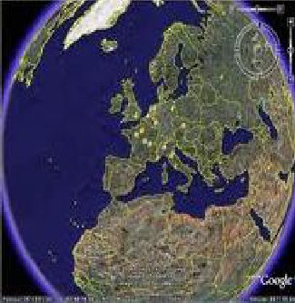
Companies like Digital Globe, design the instruments that can capture, process and display an image of reality. More Prominently Google Earth, is meant to stimulate business benefit and is part of an industry named as GIS oriented to the principle of Web Mapping.
This action needs to be done through modeling processes, in a
suggestive manner so as to obtain a spatial representation of the market’s characteristics for site suitability analysis, market selection, cannibalization ,space management in stores and many more. These new tools to be taken into consideration are computer based solutions known as Geographical Information Systems (GIS), which are used successfully in USA for market analysis of any kind. A digital map becomes a way in which spatial data, can be captured sophisticated spatial analysis and display procedures that can be integrated.
By representing and identifying the reality on a map it is
possible to show tendencies and traits
which cannot be revealed easily using only usual tabulated
data and at the most charts displays.
Transportation Routes
Satellite image Source:- Image from Google Earth
Pin codes
District map
Census data
IJSER © 2011 http://www.ijser.org
International Journal of Scientific & Engineering Research, Volume 2, Issue 11, November-2011 3
ISSN 2229-5518

In the present context of globalization of the economic activities and the expansion of knowledge management, the structured information a company owns becomes a vital resource for maintaining the level of competitiveness. GIS helps to break down the barriers between the Organizations. The quality and the opportunity of information held influences the strategic decision process, and have a major impact on the future development of the organization. In this context managers need to use powerful instruments for decision making, instruments that can capture, process and display a true image of reality in a suggestive manner through a spatial representation of its characteristics. Considering these aspects, the paper aims to draw attention on the impact of using Geographical Information Systems (GIS) in providing scientific way to solve the Business problems . Through the tools users can perform complete and complex market analysi analysis that brings together geographical, economical and census datasets. This means using complex applications for market analysis, based on GIS technologies any business scour could be achieved on real time analysis with a display of geographical
indications of the businesses as well.
GIS is changing rapidly and co-evolving along with measurement technologies, whole new levels of data volumes, computing and the cloud, networks, and science that is becoming more
quantitative and analytic. GIS is becoming more multidimensional,
easier to use, with better data management and usability, and more mobile and real-time.
People
Hardware
Processes
Recent studies show that 80% of the total data handled by decision makers in any organization, public or private, has a location or geographic component. The first thing that a business man wants to know where are my customers are arriving from ? and the first thing that the customers always wanted to know
where is the nearest retail outlet for me? Tools in GIS technology
Data in the form of digitized maps
Software technologies
answers such queries with a handy map with spatial data updated on real time basis and eases with real time solutions for selective business and personal queries.
In the USA national databases and GIS applications were created, in order to facilitate public and direct access. Obviously, a necessary condition is using powerful tools and adequate tools to analyze and process these data sources. Using these tools has great relevance on elaborating the development strategy of different companies, as they give them the possibility to use these
datasets in achieving their own objectives.
Environmental Scientific Research Institute (ESRI) are the providers of GIS software viz ARC GIS ,ARCVIEW, ARCINFO which started to pay attention to the business analysis component. and customized some examples for biggest provider of Geographic Information Systems, ESRI developed an extension specialized in Business Analysis called Business Analyst. In the USA the extension is provided together with a database that consists of business, household and demographic data. Seeing all that data on a map gives a better insight and helps in making
better decisions. With the help of ARCINFO software solution you
can analyze customer related queries and better understand their
behavior.
These systems are being used successfully in USA and in other
Countries for economic studies like consumer profiling, complex
IJSER © 2011 http://www.ijser.org
International Journal of Scientific & Engineering Research, Volume 2, Issue 11, November-2011 4
ISSN 2229-5518
marketing analysis, strategic segmentation, and logistics, in helping create and analyze market areas or analyze customer profiles. It is also easier to find people in target marketing, create analysis for locations, conduct drive time analysis, perform site prospecting etc. Geographical Information Systems are used in all economic fields and it is obvious that the modern management could exploit the geographical component more and more.
GIS Applications reached many business activities, because it is not just a way to see things and get informed, it is a way through which analysis can be performed and solutions could be found.
GIS can be found at operational, tactical and strategic decision making levels. We can say that retail is one of the fields in which a business can really take advantage of GIS benefits. If until now
GIS was used to map marketing and sales results, now more and more analytical processes would go on. In this way it becomes
very easy to determine sales areas, to identify proper retail sites, to analyze your competitors and to predict future development and sales. Different models have been developed and they all work in a GIS environment Retail marketing establishes relation between demand and supply, clients and suppliers. These two major components can be easily displayed on a map, as each of them has a geographic component and then it becomes easy to analyze with the help of GIS.
Practically, large organizations allocate considerable resources for focus-groups, for market-polls and other instruments used to determine the consumer’s profile and its behavior. But, it’s obvious that, besides the demographic information regarding: age, sex, income, family situation, etc, the managers need also the geographic information to control the expansion or to optimize
the presence on the market, facilitating in this way the management for interest zones and also the oriented marketing. Knowing the client localization area and the efficient using of this
strategic information turns into a crucial advantage.
The economic organizations must manage and use a large amount of thematic information. This information includes: a geographic localization, an address, a specific service’s area coverage, a sales territory, a delivery route that may be visualized and analyzed on
a map. The profitableness maximization is realized through a suite
of geographic applications that include selection of the best
emplacements, defining the consumer’s profile, the market-poll
and the supplying of services based on optimal localization.
As punctual connection elements between the thematic information layers, that are rigorously defined, some of the additive data is introduced in the system like the address, the pin code and the longitudes and latitudes stereographic (x, y) or
geographic coordinates.
GIS has the capacity to incorporate large databases with useful information that can be further be used in analysis and can also be showed on a map. All businesses deal with the geographic components could be thus be diaplayed in a graphical manner. In all these ways information could be made available at different levels. Top level managers can benefit from GIS applications for making strategic decisions, when deciding the markets they need to penetrate and or type of products to launch.
In marketing research GIS applications help in knowing where clients are based, in determining their profile, in the strategic analysis of the competitive environment, in finding out where the competition is located, in seeing where there is potential for expanding, and in finding out how to reach the customers through promotional activities.
Organizations can go beyond standard data analysis by using GIS tools to integrate, view, and analyze data using geography. These applications could be used across entire organization, in any field. Successful business decision makers use GIS software viz ARCGIS
, ARCVIEW, ARCINFO
Retail business processes, including market analysis, site selection, merchandising, distribution, delivery, and facilities management, involve geographic relationships. GIS enables retailers to understand and visualize these geographic relationships and improve productivity, effectiveness, and efficiency in these processes.
Predictive investigations such as market and customer analytics could also be enhanced by GIS. Many different forms of real-world and modeled data can be used with it to understand the demographic, competitive, and psychographic interaction of consumers, suppliers, and the geographic space in which the data
is distributed. The powerful technology GIS allows companies to
consider many possibilities, understand potential, review the impact of different investments, store and produce configurations, and analyze changing trends in the retail landscape.
GIS is used in different industries but in the business sector very few companies like Reliance Industries ltd Reliance Infocomm , RoltaIindia, Genesys International have taken into consideration. Its high time that Companies have realized the potential and cost advantages also the fact that GIS are platforms for knowledge management. By using this spatial enabled computer technology it is possible to turn it into a real economic advantage.
GIS applications to Retailers begin with site Suitability Analysis, District Map and updates,to analyse markets, to penetrate
IJSER © 2011 http://www.ijser.org
International Journal of Scientific & Engineering Research, Volume 2, Issue 11, November-2011 5
ISSN 2229-5518
markets, for profiling of customers, to forecast Market potential, to predict consumer buying behavior, finally to integrate in store, catalog and internet market analyses.
Modern trends are attracting our companies to focus on retailing solutions to create an application that integrates demographic, geographical and economic datasets. Reports in the date sets could be created and analyzed which helps retailers to analyze how their strategies are implemented and their consumer buying behavior . Using in the GIS platform everything would be represented on a map showing the relevance of the application and all the valuable information it can offer. Practically, it will be possible to demonstrate how the application can be used efficiently in customer profiling, sales force management, drive time analysis, market segmentation, market prospecting, marketing activities, etc and how this contributes to a better sales management.
Hypermarkets, supermarkets, etc can make their databases transparent by using GIS. In this way they will know exactly where their clients stay , their spending pattern on weekly basis
.Their average time taken to reach the retail outlet . The retailers would better know how to orientate their direct marketing, their
promotional activities and many more. Today's technology helps businesses make sense out of a sea of data to better understand who their customers are, where they are located, and where opportunities may exist. However, even in the brave new business world, nothing is perfect. Disparate data repositories, varying data formats, software complexity, and other hurdles can make it difficult to get the most out of customer information.
It is often seen for small departmental stores or retailers one company's challenge sometimes becomes another companies opportunity if the retail trade is not organized properly. To avoid or rather overcome such challenges, the nationwide retailer developed a customized market research application using ArcView and Avenue. The desktop GIS provides a means of integrating proprietary databases and allowing market researchers with little or no GIS experience to quickly and accurately analyze existing markets. The result is an advanced solution turning customer and market data into valuable information. To perform its analyses, the department uses a diverse array of data such as Access databases containing credit sales, vendor demographics, and other information gathered from proprietary, government,
and industry sources including field research.
India acquired GIS technology in the late 1990s to perform simple map production and analysis, but the technology and system designed for integration purpose was not really commercialized by the government.
Now its high time that private players should realize the business advantages viz location based advantages to enhance business decision making with tremendous cost reduction and full utilization the potential for economic advantage.
The GIS data in the form of digitized maps is made available by the Indian government agencies like National Remote sensing Agency (NRSA), Maharashtra Remote Sensing Application centre (MRSAC) and other State Centers.
The demographic data can be obtained by National Informatics Centre (NIC) for Statistical analysis of data and layers of database technology provide the real solutions of the business.
The expansion of GIS technology is a major asset for the business world. GIS is a technology is widely accepted in the US and in India , Reliance Industries has benefitted to a large extent by maintaining database of entire country for in house in the form of digitized maps and these base maps can be used for any business applications viz for optimizing transportation routes, maintenance of pipeline across globe etc. Also diversified areas of business can
be thought of. All the benefits of using spatial data are available for businesses and major providers of GIS technology take into
consideration adapting them even more to the business needs. In the present context of the market, in which competition becomes
IJSER © 2011 http://www.ijser.org
International Journal of Scientific & Engineering Research, Volume 2, Issue 11, November-2011 6
ISSN 2229-5518
more and more intense using these advanced solutions can turn into a real competitive advantage. Thus Retailers can benefit from GIS and maybe in the future can think of building a national database with data that all economic agents can access, as in case of USA. Thus GIS can bring in Significant improvements in boosting their sales , reducing costs and wastes ensuring faster decisions to the retail and marketing managers.
GIS as a tool or technology actually exists but somewhere in the analytics of the GIS process it is encountered that there is a gap in the availability of resources and interpretation from the resources in retail GIS analysis and discovery process. This is could be due to lack of skill in using and handling data. In addition, the
researchers have differing levels of computer skills and relied
heavily on "institutional" knowledge acquired over the course of
years but we have noted that something over and above software education and understanding is required to handle GIS and expertise in this technology, as use of this is specific to situation, location and needs per say.
GIS is changing rapidly and co-evolving along with measurement technologies, whole new levels of data volumes, computing and the cloud, networks, and science that is becoming more
quantitative and analytic. GIS is becoming more multidimensional,
easier to use, with better data management and usability, and more mobile and real-time.
The technology of GIS is widely accepted in the computerized US , western world, this is thus getting in the inseparable part of globalization and glocalization now as india is slowly catching up with this prevailing concept and technology. Organizations like Reliance are going on GIS for business expansions and customer satisfaction, companies feel and agree that thoughtful use of this tool is adding up to the business acumen, success and progress, thus adding to the GDP of the organization and the nation as well. There is wide gap in need demand and training in the technology, as apart from software expertise geological knowledge and geographical understanding is required to know, use and understand this technology. Future scope of research in this field would be training in geographical expertise along with software understanding required for business expansions and customer satisfactions using this technology.
• Basanu, G., Pricop, M.- Managementul aprovizionării si
desfacerii, Editura Economica,
2004, Bucahrest
• Donaldson, B -Strategic Market Relationships,. Selling and Sales
Management
• Donaldson, B - Sales Management:Theory and Practice 3rd edition, Codecs Publishing House, 2001
• Using GIS to Empower Business Solutions: the role of
Academia, Susan Wachter, article
• Bennison, D.- Retailing and the Marketing of Urban Places: a UK perspective, International Review of Retail, Distribution and Consumer Research, 15 (2), 191-215 (with G. Warnaby and B. Davies), 2005
• Bennison, D.- People and Partnerships: Marketing Urban Retailing, International Journal of Retail and Distribution Management, 2004
• Bennison, D -Explaining Retail GIS: the Adoption, Use and Development of GIS by Retail Organisations in the Netherlands, UK and Canada, Neederlandse, Study,1999
• Environmental Systems Research Institute, Inc. ArcView
Business Analyst-An ESRI White Paper
• Environmental Systems Research Institute, Inc-Case Study
• Toppen, F., Wapenaar, H.,GIS in business: Tools for Marketing
Analysis, EGIS,1994
www.colorado.edu www.nic.in www.google.com
IJSER © 2011 http://www.ijser.org