International Journal of Scientific & Engineering Research, Volume 6, Issue 2, February-2015 1152
ISSN 2229-5518
Geo-electric investigation of the groundwater Potential distribution within the Northern Basement Complex of Nigeria.
E. A. Kudamnya and J. O. Osumeje
ABSTRACT: Kaduna, a town within the crystalline hydro-geological province of the Basement Complex of northern Nigeria, is faced with an increasing demand for water due to high population growth rate and growing prosperity. Hence there is dependence on groundwater in meeting the water needs of the area. It is therefore important to delineate the water potential regions of aquifer units within the study area. To achieve this, two important hydraulic properties – hydraulic conductivity and transmissivity, of the aquifer media in the area were computed. A geoelectric survey was carried out involving Vertical Electrical Sounding (VES) to investigate the sub-surface depth using the Schulmberger technique. Abem Tarrameter SAS 1000 was used and twenty points were sounded in area. Data obtained were processed using the Earth Imager 1D Version 2.0.4 software to display results in a log-log graph. Values for transmissivity and hydraulic conductivity were computed. The data together with the coordinate of points for each station, obtained using a Garmin global positioning system (GPS), was employed to plot 2D and 3D contour maps. This was done with the aid of Surfer 11 software. In
conclusion, transmissivity values recorded is within a range of 1.31 m2/day to 20.08 m2/day, with an average value of 19.12 m2/day. Hydraulic
conductivity values range from 6.5827 x 10⁻⁶ m/s to 9.7225 x 10⁻⁶ m/s with an average value of 7.5358 x 10⁻⁶ m/s. Aquifer thickness recorded a range of value between 2.00 m to 31.00 m with an average of 15.66 m. Groundwater yield in the study area is adequate to sustain water supply need of communities like Afaka and Riga Chikun. Other places like Kurumi Mashi and Makera will have just enough water for private use. There is a strong positive correlation between transmissivity and aquifer thickness, while there was no correlation between aquifer transmissivity and aquifer resistivity.
Keyword: Hydraulic conductivity, transmissivity, groundwater, aquifer, groundwater,vertical electrical sounding (VES).
1. INTRODUCTION
+234 803 481 8736 +234 803 291 9520
The occurrence of groundwater may vary from one place to
Kaduna is faced with an increasing demand for water due
to high population growth rate and growing prosperity.
Especially in a time where taps being supplied pipe-borne
water from the state water board are no longer running but
dry. Thus, the importance of groundwater in meeting water
needs cannot be over-emphasized. Groundwater occurs in
the interstices or pore spaces of weathered crystalline
basement and sedimentary rocks within geological medium
called aquifer. Sometimes, they occur in inter-connected
fractures or fissures of fresh crystalline rock, in which case
they are referred to as fractured aquifer. The aquifers of
the Basement Complex rocks are the regolith and the
fractures in the fresh bedrock which are known to be
inter-connected at depth [1], [2]. However, [3] described
regolith aquifer in the crystalline basement of Nigeria as
partly overlain by a shallow, porous aquifer within the
————————————————
• Ebenezer Agayina KUDAMNYA (a Hydrogeologist) is currently a
lecturer at the Department of Geology, University of Calabar, Nigeria, PH-
+23408034818736. E-mail: obeydelaw2013@gmail.com
• Joseph Orojah OSUMEJE, (a Geophysicist) is currently a lecturer at the
Department of Physics, Ahmadu Bello University, Zaria, Nigeria, PH-
+23480329191520. E-mail: josumejeh@yahoo.com
lateritic soil cover.
another depending on the aquifer inherent hydraulic
properties. Thus, the transmissivity and hydraulic
conductivity of an aquifer both depends on the properties
of the medium (rock material) as well as of the fluid or
water [4]. Knowledge of these two can be used to determine
the groundwater potentiality of an area during exploitation
of the resource. Conventional method of determining
hydraulic properties is by drilling/pumping test, although
expensive and time consuming. A relatively inexpensive
and quick method employs the Dar Zarrouk parameters [5],
together with results from geo-electrical surveys. There are
several works that has shown that the Dar Zarrouk
parameter (of transmissivity and conductivity) and the
geologic information of an area can be used to compute the
distribution of water potential surfaces: [6], [5], [7], [8], [9],
[10], [4].
According [11], the areas underlain by migmatite-gneiss
complex and schists of the Younger Metasediments
represent generally a poor groundwater terrain due to
their lithological and structural characteristics. These
unconsolidated materials are known to reflect some
dominant hydrologic properties, and the highest
groundwater yield in Basement Complex area are found
in areas of thick overburden overlying fractured zones
and are characterized by relatively low resistivity, [12], [13],
[14].
IJSER © 2015 http://www.ijser.org
International Journal of Scientific & Engineering Research, Volume 6, Issue 2, February-2015 1153
ISSN 2229-5518
This study aims to employ hydro-geophysical parameters which include the Dar Zarrouk parameter and geoelectrical resistivity data to estimate the hydraulic conductivity (K) and transmissivivty (T) in order to determine the groundwater potential distribution of the study area.
2. LOCATION AND GEOLOGY OF THE STUDY AREA
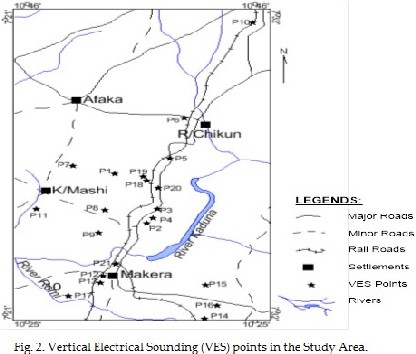
The area is bounded by latitudes 10°25ˈN and 10°46ˈN and Longitudes 7°21ˈE and 7°32ˈE. It covers towns that include Afaka, Riga-Chikun, Kurmin-Mashi and Makera in Kaduna State. It covers an area of approximately 780.84 Km2, in the Basement Complex of North Central Nigeria (Fig. 1).
The Nigerian basement complex forms a part of the Pan- African mobile belt and lies between the West African and Congo Cratons [15]. According to [16], the Northern
Nigerian Basement Complex is underlain by three main groups of rocks namely:
1. Migmatites and (high grade) gneisses derived from Birrimain sedimentary rocks through high grade metamorphism and granitization;
2. Younger Metasediments of Upper Proterozoic age which are low grade metamorphic rocks that were folded along with the migmatite and gneisses during the Pan-African orogeny;
3. Older Granite series which were intruded during the Pan- African orogeny.
Ajakaiye et al. [17], reports that the oldest rocks are metesediments, which have been transformed to gneisses and migmatites during two tectono-metamorphic cycles. The first orogenic cycle characterized a period of deformation and folding during the epiorogenic uplift, [18].
Fig. 1: The Geology and Location of the Study Area.
The age suggested for this was the Eburnean, (1850 ± 250) Ma by syntectonic metamorphism of probably siltstones and mudstones. The second orogeny occurred after the Pan- African (650 ± 150) Ma, as a result of contact metamorphism due to thermal effect of the Granitic intrusion during the Eburnean Orogeny according to [19]. This marked the end of the Pan-African event in Nigeria. The area under study is represented by two distinct lithological units, namely the Older Granite suite and the gneissic rocks (see Fig. 1). However, weathering of the
crystalline Basement Complex rocks under tropical condition is well known to produce a sequence of unconsolidated material whose thickness and lateral extent vary extensively [20].
3. THEORETICAL BACKGROUNDS Geologists have used resistivity information to quantitatively assess the permeability of clay alluvium over the years. From the geologic conditions, it is sometimes
IJSER © 2015 http://www.ijser.org
International Journal of Scientific & Engineering Research, Volume 6, Issue 2, February-2015 1154
ISSN 2229-5518
convenient to relate the Dar Zarrouk parameters of transmissivity and conductivity to explore for water. The yield of a bore hole can be determined from the hydraulic transmissivity. Several authors have explained the expressions used for exploration of groundwater by geo- electrical resistivity method. For instance, [21], [22], [23], [24], [25] have all carried out studies relating to the Dar- Zarrouk parameters.
On a broader view, geophysicists apply Physics Laws to study the earths subsurface. Thus, groundwater flow in a porous medium is governed by Darcy’s law and it is analogous to the Ohms law. Details of the theories can be found in [4] and [26] respectively. The Dar-Zarrouk parameters used in this work are the conductivity (K) and the transmissivity (T).
Hydraulic Conductivity (K) is a measure of the ability of a formation to transmit water. It is expressed in m s-1. While transmissivity (T) is the time-rate of flow of water at the prevailing field temperature under a unit hydraulic gradient through a vertical strip of aquifer of unit width and extending through the entire saturated thickness of the aquifer. It is expressed in m2 d-1 or m2 s-1.
Darcy’s law, in terms of T, can be expressed as;
Q = TIL (1)
Where Q = rate of flow, I = hydraulic gradient, L = width of
the flow section, measured at right angles to the direction of
flow.
In a confined aquifer like that of the study area,
T = Kb (2)
Where b is the saturated thickness of the aquifer and K is
assumed to be an isotropic and constant across the
thickness of the aquifer which may be horizontal or dipping
[4].
There exist a relationship between transmissivity (T) and
resisitivity (ρ). This relationship which can be expressed as
K is either decreasing or increasing and it has generally
been proved to contain an exponential fit between
transmissivity (T) and resisitivity (ρ) [24], [25], [4]. The
present study area is located in a basement complex region
with evidence of hard rocks. Based on [27], depending on
the geologic formation of the study area, the value of K in
equation 2 can be expressed as;
K = b x 8 x 10⁻⁶e⁻⁽°.͘͘͘͘ °°13ρ) (3)
Where b = the aquifer thickness (m), ρ = the resistivity of the
aquifer in (Ωm).
Knowledge of permeability and transmissivity distribution
is decisive for any groundwater development or
consideration. In hydro-geologic maps, transmissivity has
been the best hydraulic property to clearly express ground
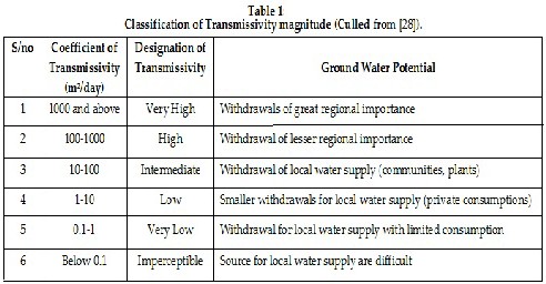
water potentia [28], Table 1.
In this research work, the Schlumberger array technique
has been used to obtain the Vertical Electric Sounding
(VES) from which the thickness and resistivity of the
aquifer was obtained. Fig. 2 shows the location of the VES
points around the study area.
IJSER © 2015 http://www.ijser.org
International Journal of Scientific & Engineering Research, Volume 6, Issue 2, February-2015 1155
ISSN 2229-5518
4. MATERIAL AND METHODS
The schulmberger technique which is best for probing depth was used to acquire the Vertical Electrical Sounding (VES) data. This technique has long been used to source for water in any type of geologic setting. In this study, Abem Tarrameter SAS 1000 was used and twenty points was sounded in areas were drilling could be done as shown in Fig. 2. The data collected was processed using the EarthImager 1D Version 2.0.4 software. This software was able to display a processed result in a log-log graph. From
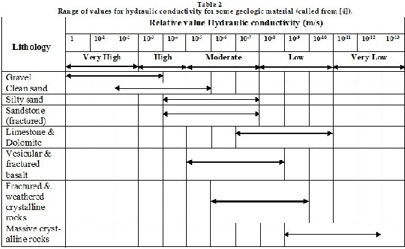
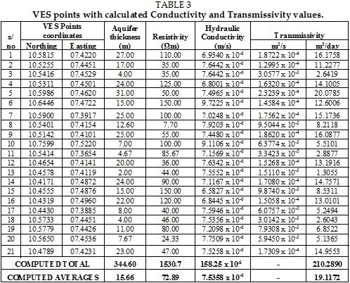
the result, the weathered aquifer was identified with its resistivity as shown in Table 2. By using equations 2 and 3, values for transmissivity and hydraulic conductivity were computed (see Table 3). These data, together with the coordinate of points for each station was plotted to obtain using a Garmin global positioning system (GPS) and obtained a 2-dimensional contour maps as shown in Fig. 2,
3, 4, 5 and 6 below. This was done with the aid of Surfer 11 software.
IJSER © 2015 http://www.ijser.org
International Journal of Scientific & Engineering Research, Volume 6, Issue 2, February-2015 1156
ISSN 2229-5518
5. RESULTS DISCUSSION
Results obtained from the vertical electrical sounding was
documented in Table 3 showing co-ordinates of VES points
with the estimated thickness of the aquifer, its associated
resistivity value, and the computed total and average
values for conductivity and transmissivity according to the
equations (2) and (3).
These data were used to obtain contour maps for the
aquifers’ thickness, resistivity, hydraulic conductivity and
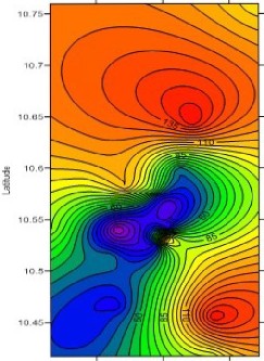
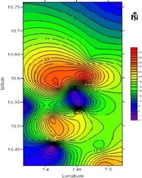
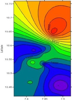
transmissivity. They are represented by Fig. 3, 4, 5 and 6.
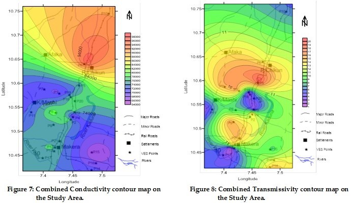
Fig. 7 is the combined aquifer transmissivity contour map and the study area map while Fig. 8 is the combined aquifer conductivity contour map and the study area map. Transmissivity values recorded are within a range of 1.31 m2/day to 20.08 m2/day, with an average value of 19.12 m2/day. Hydraulic conductivity values range from 6.5827 x
10-6 m/s to 9.7225 x 10⁻⁶ m/s with an average value of 7.5358 x 10⁻⁶ m/s. Aquifer thickness recorded a range of value between 2.00 m to 31.00 m with an average of 15.66 m.
IJSER © 2015 http://www.ijser.org
International Journal of Scientific & Engineering Research, Volume 6, Issue 2, February-2015 1157
ISSN 2229-5518
Thus, on the basis of its average transmssivity values the study area can be classified to have ‘intermediate’ transmissivity according to [28] classification, see Table 1. On the basis of the entire range of data collected (1.31 m2/day to 20.08 m2/day), the area was generally classified to have ‘low to intermediate’ transmissivity distribution as shown in table 1. This is because the distribution of groundwater potential on the basis of its transmiissivity, were reflected in the transmissivity contour map (Fig. 6). Relatively higher potential for water is located at the middle of the study area, extending towards both the northwest and southeast direction. This area is estimated to cover probably about 75-80% of the entire study area and on the basis of their transmissivity values recorded shows intermediate potential. Furthermore, location indicating transmissivity values of less than 10.00 m2/day represented by the blue colour are classified as the ‘low transmissivity’
potential areas. They occupy approximately 20-25% of the study area. When the transmissivity map is draped over the study area map, settlements with intermediate groundwater potential for local use include; Riga Chikun, Afaka, and Makera, while Kurmin Mashi is located in the low groundwater potential area.
Regions that record low transmissivity occur around areas with exposures of rock outcrop. This is probably so because of low porosities where the crystalline rocks are poorly fractured. They correspond to the areas with small aquifer thickness, see Fig. 3 and 4. Groundwater in the study area occurs within two aquifers - the Soft Overburden Aquifer and Fractured Crystalline Aquifer. This is evident as when type of aquifer medium conforms to the desired range of values obtained from the hydraulic conductivity as shown in Table 2.
IJSER © 2015 http://www.ijser.org
International Journa l of Scientific & Engineering Research, Volume 6, Issue 2, February-2015

ISSN 2229-5518
1158
(4 r.4t.
l.ong11U<lc
1.!,
Fig.3. Aquifer Resistivity contour map.
Long.tude
Fig 5. Conductivity contour map.
Fig. 4. Aquifel' thickness contour map.
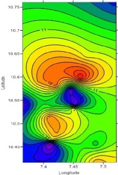
Fig. 6. Transmissivity contour map.
IJSER 2015 http //www 11ser.org
International Journal of Scientific & Engineering Research, Volume 6, Issue 2, February-2015 1159
ISSN 2229-5518
Since weathering of the crystalline Basement Complex rocks under tropical condition is well known to produce a sequence of unconsolidated material whose thickness and lateral extent vary extensively, we can say that from the hydraulic conductivity (see Table 2 and Fig. 8) in the range of 10-6 ms-1 in the study area is fractured and
weathered crystalline rock according to [4]. The Fig. 5 shows the distribution of the conductivity of the study area. Riga Chukin has the highest value.
The aquifer-thickness contour map has shown good correlation when compared to the transmissivity contour map (see Fig. 4 and 6). Transmissivity is characteristic of
IJSER © 2015 http://www.ijser.org
International Journal of Scientific & Engineering Research, Volume 6, Issue 2, February-2015 1160
ISSN 2229-5518
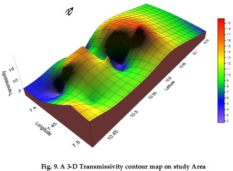
fluids and the aquifer material but also depends the saturated thickness (compare Fig. 4 and 6). This shows that thicker aquifers can support the storage and yield of more groundwater, which in-turn implies good water potentials. A 2D model showing distribution of hydraulic conductivity (Fig. 7) in the study area is obtained, while the same model for transmissivity distributions is represented in Fig. 8. A
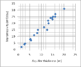
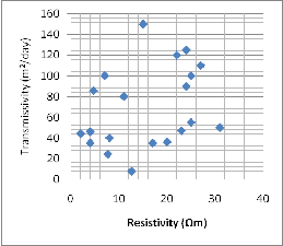
3D model for the transmissivity distribution in the area clearly illustrates potential regions of higher groundwater yield with respect to regions of lower yield. In Fig. 11(a) there is a strong positive correlation between plots of
aquifer transmissivity versus aquifer-thickness, while for a plot of aquifer transmissivity versus electrical resisitivity shows no correlation between them. This probably suggest that a thicker weathered overburden store more water, thus the transmissivity will also be high and consequently indicating a higher potential.
On a broad scale, the groundwater potential of this area ranges in quantity from large withdrawal for local water supply (as community consumption) to smaller withdrawal for local supply (private consumption) according to Table 1.
(a) (b)
Fig. 10. A correlation plot of aquifer transmissivity against aquifer thickness is shown in (a) while correlation plot of aquifer transmissivity against electrical resistivity is shown in (b).
6. CONCLUSION
Hydrological parameters are important in ground water
prospecting. The conventional methods of obtaining this
parameters involves drilling (which is usually expensive),
however, a less expensive and faster method of obtaining
this parameter was used in this research work to determine
the ground water potential of the study area. The geology
of the study area has encouraged the use of this technique
to determine conductivity and transmissivity values of the
area.
The result has been compared with previous standard
values. Transmissivity values recorded have a range of 1.31
m2/day to 20.08 m2/day. Average transmissivity value
computed was 19.12 m2/day. The ground water potential of
this study area has been determined to be from intermediate to low on the transmissivity scale. Localities like Riga Chikun, Afaka, and Makera has been found to have intermediate groundwater potential for local use, while Kurmin Mashi is located in the low groundwater potential area.
This implies that the groundwater yield is adequate to sustain water supply need of communities like Afaka and Riga Chikun. Other places like Kurumi Mashi and Makera will have just enough water for private use. There is a strong positive correlation between transmissivity and aquifer thickness, while there was no correlation between aquifer transmissivity and aquifer resistivity.
REFERENCE
1). S.A. Alagbe. Hydrogeology of the River Kangimi Catchment Area, Kaduna State. Unpub. M. Sc. Thesis, Dept. Geol., Ahmadu Bello University, Zaria, p. 168, 1987.
2). E.A. Adanu. Hydrogeology of the Basement Complex Terrain in the Zaria – Kaduna Area (Nigeria). Ph.D. Thesis, FU TFH TU, Berlin, p. 75, 1989.
3). A.E. Annor and P.I. Olasehinde. Vegetational Niche as a Remote Sensor for Subsurface Aquifer: A Geological- Geophysical Study in Jere Area, Central Nigeria. Water Resources, 7, pp26-30, 1996.
4). B.B.S. Singhal and R.P. Gupta. Applied Hydrogeology of Fractured Rocks, 2nd Edition. Academic Publishers (now Springer), pp141-143, 1999. ISBN 978-90-481-8798-0. DOI
10.1007/978-90-481-8799-7.
5). R. Maillet. The Fundamental Equations of Electrical
Prospecting: Geophysics, Vol. 12, No. 4, pp.529- 556, 1947.
doi:10.1190/1.1437342.
6). A.A.R. Zohdy. The Auxiliary Point Method of Electrical
Sounding Interpretation and its Relationship to the Dar
IJSER © 2015 http://www.ijser.org
International Journal of Scientific & Engineering Research, Volume 6, Issue 2, February-2015 1161
ISSN 2229-5518
Zarrouk Parameters. Geophysics, vol. 30, no. 4, pp644-660,
1965.
7). M.S. Hantush. Hydraulics of Wells. Advances in Hydro-
science, vol. 1, pp281-432, 1964.
8). S. Niwas and D.C. Singhal. Estimation of Aquifer
Transmissivity from Dar-Zarrouk Parameters in Porous
Media: Journal of Hydrology, Vol. 50, pp. 393-399, 1981. doi:
10.1016/0022-1694(81)90082-2
9). R. Frohlich and W.E. Kelly. The Relation between
Transmissivity and Transverse Resistance in a Complicated
Aquifer of Glacial Outwash Deposits: Journal of Hydrology,
Vol. 79, 1985, pp. 215-219, 1985.
10). K.M. Onuoha and F.C.C. Mbazi. Aquifer
Transmissivity from Electrical Sounding Data of the Case of
Ajali Sandstone Aquifers, South East of Enugu, Nigeria. In:
C.O. Ofoegbu (ed.). Groundwater and Mineral Resources of
Nigeria. Friedvieweg & Son Pub.: Berlin, Germany, pp17-29,
1988.
11). A.E. Bala, O.M. Eduvie and J. Byami. Borehole Depth
and Regolith Aquifer Hydraulic Characteristics of Bedrock
Types in Kano Area, Northern Nigeria. African Journal of
Environmental Science and Technology, vol.5 (3), pp.228-237,
2011.
12). A. Aderinto. Estimation of Aquifer Transmissivity in
the Basement Complex using Dar Zarrok Parameters.
Unpubl. M.Sc. Thesis. Department of Geology, University
of Ibadan, pp50-60, 1986.
13). M.A. Olurunniwo and Olorunfemi. Geophysical
Investigation for Groundwater in Precambrian terrains: A
Case History from Ikare, South-Western Nigeria. Journal of
African earth sciences 6, pp. 787-796, 1987.
14). M.O. Olurunfemi and S.A. Fasuyi. Aquifer Types
and the Geoeletric Hydrogeologic Characteristics of Part
of the Central Basement Terrain of Nigeria (Niger State).
Journal of Africa Earth Science 16, pp.309-317, 1993.
15). N.G. Obaje. Geology and Mineral Resources of Nigeria, Lecture Notes in Earth Sciences 120, pp13, 2009. DOI
10.1007/978-3-540-92685-6 2
16). P. McCurry. A General Review of the Geology of the
Precambrian to Lower Palaeozoic Rocks of Northern
Nigeria. In: Kogbe, C. A. (ed) Geology of Nigeria, pp13-37,
1989.
17). D.E. Ajakaiye, D.H. Hall and T.W. Millar.
Interpretation of Aeromagnetic Data across the Central
Crystalline Shield Area of Nigeria: In Kogbe, C. A. (ed),
Geology of Nigeria, pp. 81 – 83, 1989
18). P. McCurry. Plate tectonics and the Pan African
Orogeny in Nigeria. Nature, Volume 229, pp. 154 – 155,
1971.
19). P. McCurry. Geology of Sheet 102, Zaria. Unpublished
PhD thesis submitted to the Ahmadu Bello University
Zaria, 1973.
20). W.R. Dearmaun, F.J. Dayness and T.T. Irfah.
Engineering Grading of Weathered Granite. Engineering
Geology No. 12, pp.345-374, 1978.
21). P.K. Bhattacharya and H.P. Patra. Direct Current

Electrical Sounding. Elsevier, Amsterdam, pp135, 1968.
22). O. Koefoed. Geosounding Principles 1; Resistivity
Sounding Measurements, Elsevier, Amsterdam, 1979.
23). F.C. Frischknecht and G.V. Kellev. Electrical Methods in
Geophysical Prospecting, 1966. ISBN10:008011525X | ISBN-13:
9780080115252
24). W.K. Kosinky and W.E. Kelly. Geoelectrical Sounding
for Predicting Aquifer Properties: Groundwater, 19, pp163–
171, 1981.
25). N. Sri and D.C. Singhal. Aquifer Transmissivity of
Porous Media from Resistivity Data, J. Hydrol.82, 143–153,
1985.
IJSER © 2015 http://www.ijser.org