International Journal of Scientific & Engineering Research, Volume 4, Issue 12, December-2013 1135
ISSN 2229-5518
Growth of Small Towns in the Surroundings of Guwahati City, Assam, India
Rinku Manta* Jnanashree Borah**, and Jayashree Borah***
Abstract- Urbanization carries several important dimensions that collectively and individually produce macro and micro impacts on the society and everyday life. Among these dimensions, Urban Geography and Regional planning are the most expanding sub-disiciplines of Geography to identify and account for the distribution and growth of towns and cities and spatial similarities and contrasts that exists within and between them, and their role in regional and urban development over the last decades both in terms of theoretical concepts and practical applications. The paper attempts to assess the growth of the small towns in the surroundings of Guwahati city in terms of its origin, size and spatial distribution.
In order to achieve the study’s objectives, secondary sources have been taken, like Census of India Reports, Statistical Handbook of Assam, Master plan and City Development Plan. The study depicts that the growth of small towns in the surroundings of Guwahati city is stagnant, slow and high based on decadal growth of towns for a period of 1901-2001. The Spatial distribution of small towns in the study region reveals unevenness, linear and scattered in pattern and high concentration around the Guwahati city. the trend of urbanisation in the study region is found to be remarkably high as compared to the situation of Assam, due to the dominance of the lone Class-I city i.e Guwahati.
Key Words: Urbanisation, dimensions, spatial, growth, surroundings, stagnant, dominance
INTRODUCTION:
Urbanization is an index of transformation from traditional rural economies to modern industrial one. It is a long term process. “Understanding of Urbanisation” (Jha, 2006), the term is related to the core concern of Urban Geography. It stands for the study of Urban Concentration and Urban phenomena. By Urban Concentration what is meant in the different forms of urban setting; and by urban phenomena we mean all those processes that contribute to the development of urban centers and their resultant factors. Thus the scope of the term is certainly comprehensive. (Mallick, 1981). Urbanization carries several important dimensions that collectively and individually produce macro and micro impacts on the society and everyday life. Among these dimensions, Urban Geography and Regional planning are the most expanding sub-disiciplines of Geography to identify and account for the distribution and growth of towns and cities and spatial similarities and contrasts that exists within and between them, and their role in regional and urban development over the last decades both in terms of theoretical concepts and practical applications (McKinney Global Institute 2010).
Urbanization in India has occurred more slowly than in other developing countries and the proportion of the population in urban areas has been only 28 per cent based on the 2001 census, which has increased to 31.16 percent in
2011 Census. Level of urbanization increased from 27.8 percent in 2001 Census to 31.16 percent in 2011 Census. India
shares most characteristic features of urbanisation in the developing countries. Number of urban agglomeration
/town has grown from 1827 in 1901 to 5161 in 2001. Out of the total 5161 towns in 2001, 3800 are statutory towns and
1361 are census towns. The number of statutory towns and census towns in 1991 was 2987 and 1702 respectively. The
number of total population has increased from 23.84 crores in 1901 to 102.7 crores in 2001 whereas number of population residing in urban areas has increased from 2.58 crores in 1901 to 28.53 crore in 2001. It reflects a gradual increasing trend of urbanization. India is at acceleration stage of the process of urbanization. (Shah, 2006). Large cities are the focus of urban policies and programmes (Mahadevia, 1999), though poverty is concentrated in the small towns (Dubey, 1999), which also have lower levels of basic services than the large cities (Kundu 1999). Surging growth and employment in cities will prove a powerful magnet. 300 million Indians currently live in towns and cities. Within 20-25 years, another 300 million people will get added to Indian towns and cities. This urban expansion will happen at a speed quite unlike anything that India has seen before. It took nearly forty years for India’s urban
IJSER © 2013 http://www.ijser.org
International Journal of Scientific & Engineering Research, Volume 4, Issue 12, December-2013 1136
ISSN 2229-5518
population to rise by 230 million. It could take only half the time to add the next 250 million. If not well managed, this inevitable increase in India’s urban population will place enormous stress on the system.
Urbanization in Assam is one of the last frontiers in India where large urbanization began (Das.A, 2007). Assam is one of those states of India, which is traditionally rural in character with agriculture and allied activities being the primary occupation of its population. However, over the years there has been an upward trend towards urbanization and it got momentum particularly in the post independence era. While the share of urban population to total population of Assam in 1951 was only 4.29 percent it increased to 12.1 percent in 2001 and 14.08 percent in 2011
Census which is still lower than the national average of 27.78 percent. Even among the North-eastern states, Assam has the lowest urbanization, while Mizoram having 49.5 percent urbanization, and is the highest. Among all the districts of Assam, Kamrup is the most urbanized with 35.81 percent urbanization.
Guwahati city the capital of the state is the largest urban centre in Assam with 23.89 percent of the total urban population of the state. Guwahati has been the capital of the reorganized state of Assam since 1972. Prior to that, Guwahati has never served even as the State Headquarters. The population of Guwahati Metropolitan Area has grown almost 6.5 times between 1971 and 2001. The municipal limit of the city increased from 7.68 sq.km in 1951 to
14 Sq. km. in 1961, which further increased to 43.82 sq.km in 1971 and 216.79 sq.km. in 1991. The city achieved its municipal corporation status in 1974. Interestingly, for the past 10 years, the Guwahati city has experienced deranged growth leading to drastic change in its landuse and land cover.
The nature of urban growth in a study region is understood at the state level and than by further disaggregating down to the district level. Even then the nature of towns’ growth remains unclear (Sivaramakrishna,
2005). In the present study, the growth of small towns is examined in terms of origin and growth pattern of small
towns in Assam and in the study region.
The paper attempts to focus on the growth of small towns in surrounding of Guwahati city in terms of its origin, size and spatial distribution, in the surroundings of Guwahati city.
METHODOLOGY:-
The analysis for growth of towns in the surroundings of Guwahati city is based on secondary data obtained from different sources as Census of India Reports, Statistical Handbooks of Assam, Census Town Directory, Master Plan, and City Development Plan. The Census Reports 2011 was published in 2013 and hence it couldn’t be used in the present study which was carried on in the year 2011.
The data have been analysed with the help of statistical techniques and inferences are drawn based on these:-
Demarcation of the Study Region:-
In the present study regionalisation of Assam has been done based on urban centres, for the purpose of demarcation of the study area. The regionalisation is done by adopting population potential model.
The details of the construction and application, the versions of the basic population potential model vary
in three main ways: in their interpretation; in the phenomena dealt with; and in the reasons for using them. Gopal Krishan and S.C Gupta has modified population potential model and used for regionalisation of India on the basis of relative population potentials of cities. The study uses data by individual cities for the three post- Independence censuses from 1951-71 and presented a dynamic picture of regionalisation in India. The model is published in R.P. Mishra’s Regional Planning: Concepts, techniques, policies and case studies (Mishra 1992) which is a Reprinted from Area, Institute of British Geographer. This objective has been achieved by computing population potential of towns upon each other by identifying dominant towns, henceforth called the regional centres, and by delimiting population potential zones of various regional centres (Gupta and Krishnan, 2002). The significance is three fold. First, a system of regional centres, along with zones of their population potential, is identified; a knowledge of which may be usefully employed in any scheme of regional or national planning. Secondly, the number, spacing and locational pattern of regional centres would reflect imbalances in urban development. Thirdly, it would be of great academic interest to compare these zones with the physical, economic, cultural or administrative divisions.
The formula used for this purpose was: Population potential of a town:
X upon Y town = Population of town X
IJSER © 2013 http://www.ijser.org
International Journal of Scientific & Engineering Research, Volume 4, Issue 12, December-2013 1137
ISSN 2229-5518
Distance in kilometres between town X and town Y
Since, the demarcation of the study area in the present research is based on aforesaid model, the methods, techniques, and limitations remain same.
Following are the steps followed for demarcation of the study area:-
• For the present study, the very first step was to locate all the 126 towns of Assam on an outline map of
Assam. Based on the population size, 7 towns namely, Guwahati, Nagaon, Dibrugarh, Jorhat, Silchar, Tinsukia and Dhubri have been identified as dominant towns hence forth called Regional centres. Moreover, these towns give a spatial coverage of whole of Assam, from north to south, east and west and the central part of it.
• The next step was to find out the distance between various towns with the specific regional centres. Since
most of the inter –town goods and passenger traffic moves by road transport, it was deemed proper to adopt the shortest road distance which was noted from the Census Town Directory 2001.
• This stage is followed by identification of population potential zones .The population potential of all 126
small towns of Assam upon the selected 7 regional centres were calculated with the help of the aforesaid model. The towns whose population potential of a specific regional centre was the highest would come under the purview of that particular regional centre.
• The zonal boundaries were drawn by joining the mid points of two towns falling into two different regional centres (Figure 1).The boundaries of the population potential zones do not correspond with those of administrative, physical or cultural divisions of Assam.
• Thus, 7 population potential zones have been created. Among seven population potential zones of Assam
the Guwahati population potential zone covers total of 24 small towns. The Guwahati population potential zone i.e the study region, comprises of 24 small towns namely, Barpeta Road, Sarbhog, Barpeta, Howli, Bohari, Sarthebari, Pathsala, Rangia, Sualkuchi, Bamun Sualkuchi, Palasbari, Kochpara, Dharapur, North Guwahati, Chandrapur, Tihu, Nalbari, Tangla, Mangaldoi, Kharupetia, Udalguri, Jagiroad, Marigaon and Guwahati (Table 1).
Growth Index:-
To analyze the growth behavior of small towns of the region the following formula has been applied. Growth
Index of small towns:

GI= P2 x 100 Where, P2 = Population of small towns in recent decade. (i.e. Year for which the P1 GI is required)
P1 = Base year C (i.e. 1901 in present context).
To find out the growth index the population of all the 24 small towns for the year 2001 in the surrounding of Guwahati city and for the base year 1901 has been taken. Growth index of small towns in the region during various decades include two distinct phases, viz. (i) Pre-Independence period and (ii) Post- Independence period.
Size Index:-
For the study of distribution of small towns the grid map is studied with the help of equal grids made in the
interval of 15˚ mins latitude and longitude.
To study the size character of small towns of Assam, it has been quantified in terms of ‘Size Index’ obtained by the following formula:
SI = Pc X 100 Where, Pc = Population of small towns
PR
PR = Population of region/ district.
Different small towns have been grouped under index categories in the name of their size rank
IJSER © 2013 http://www.ijser.org
International Journal of Scientific & Engineering Research, Volume 4, Issue 12, December-2013 1138
ISSN 2229-5518
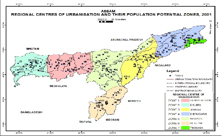
Figure 1 Regional CIentres oJf UrbanisationSand their PopulaEtion Potential ZonRes Assam, 2001
IJSER © 2013 http://www.ijser.org
International Journal of Scientific & Engineering Research, Volume 4, Issue 12, December-2013 1139
ISSN 2229-5518
Table 1 Distribution of Urban Centers in Different Urban Population Potential Zones in Assam, 2001
IJSER
Data Source: Census of India 2001, Town Directory
IJSER © 2013 http://www.ijser.org
International Journal of Scientific & Engineering Research, Volume 4, Issue 12, December-2013 1140
ISSN 2229-5518
IJSER
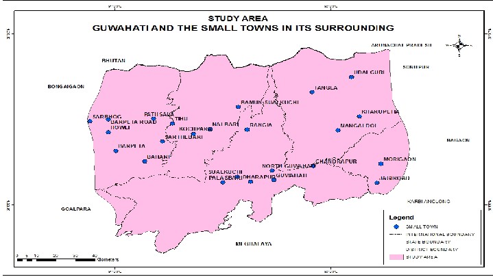
Figure 2 Study Area, Guwahati and the Small Towns in its Surrounding
GROWTH OF SMALL TOWNS IN THE STUDY REGION
Based on number of towns being declared by Census in every decade it is seen that although Assam is traditionally rural in character with agriculture and allied activities being the primary occupation of its population, over the years there has been an upward trend towards urbanization and it got momentum particularly in the post independence era. The growth behaviour of small towns of the study region reveals the fluctuating fortunes of their growth history. An overall trend reveals that in general the small towns of the region have established their continuity of growth right from the time of independence (Table 2). To know the origin of small towns in Assam as a whole and the study region in particular, towns were studied from the Census Town Directory, 2001 and arranged in a tabular form.
IJSER © 2013 http://www.ijser.org
International Journal of Scientific & Engineering Research, Volume 4, Issue 12, December-2013 1141
ISSN 2229-5518
Table 2 Growth of Small Towns in the Study Region
IJSER
Data Source: Census of India 2001, Town Directory Assam
An overall trend reveals that in general the small towns of the region have established their continuity of growth right from the time of independence. During the Census year 1901 twelve towns emerged in Assam, out of this total 6 towns have grown into dominant urban centres in the due course of time. These 6 towns are considered as the Regional Centres to draw the regions of Assam based on urban centres (Figure 1). Out of the total twelve towns 2 towns belong to study region namely, Guwahati and Barpeta (Table 2). Next forty years i.e till 1941only eleven towns emerged out of which 3 towns originated in the study region these are Palasbari, Nalbari and Mangaldoi. During
1951-71 i.e the period of post- independence 46 new towns emerged in Assam out of which ten new towns emerged
in the study region. They are Tihu, Tangla, Kharupetia, Barpeta Road, Sarthebari, Rangia, Sualkuchi and North Guwahati. From 1971-81, seventeen towns originated in Assam, among these seventeen 2 towns originated in the study region namely, Howli and Sarbhog. During 1981- 2001 total of fifty six new towns emerged in Assam and out of which 9 towns emerged in the study region, they are Jagiroad, Marigaon, Udalguri, Pathsala, Dharapur, Bohari, Kochpara and Chandrapur. By the year 2001, 24 towns emerged in the study region they are Guwahati, Barpeta,
IJSER © 2013 http://www.ijser.org
International Journal of Scientific & Engineering Research, Volume 4, Issue 12, December-2013 1142
ISSN 2229-5518
Nalberi, Palasbari, Mangaldoi, Tihu, Tangla, Kharupetia, Barpeta Road, Sarthebari, Sualkuchi, Bamun Sualkuchi, Rangia, North Guwahati, Kochpara, Bohari, Udalguri, Marigaon, Jagiroad, Chandrapur, Sarbhog, Howli, Pathsala and Dharapur.
Table 3 Towns Declassified and wholly merged with others during 1971-81
Name and status of the town | Population 1971 census |
(a) Declassified i)Ramakrishna Nagar (CT) | 6,657 |
(b) Wholly merged with other town i)Pandu (CT) GuwahatiMunicipal Corporation ii)Kamakhya (TC) | 38,876 6,397 |

Data Source: Census of India, 1991
As mentioned in the Table 3, that in between 1971-81, 2 towns of 1971 Pandu and Kamakhya, were merged with the
Municipal Corporation of Guwahati and, one town, Ramakrishnagar in Cachar district, was declassified in 1971 as
1981.
GROWTH PATTERN: TEMPORAL PHASE ASSESSMENT
The growth history of individual small towns reveals the fact that no small towns of Assam have constant growth
characteristics. To know the pattern of growth in a phase manner for a period of 100 years, Growth Indices has been employed. Growth Indices i.e GI is obtained in percent by dividing population of a small town by the population of the base year i.e 1901 for the present study.
The stagnant or slow and negative population growth shows that they are poor in their functional stand. Decadal emergence of 24 towns in the study region shows that either there is no addition of new towns or the maximum of 7 towns, as such a range have been prepared to examine the growth pattern as stagnant growth with no addition of towns, slow growth with maximum addition of 2 towns and the high growth with addition of 3 to 7 towns (Table 4).
IJSER © 2013 http://www.ijser.org
International Journal of Scientific & Engineering Research, Volume 4, Issue 12, December-2013 1143
ISSN 2229-5518
Table 4 Growth Indices of Small Towns in the Study Region
Data Source: CensusIof IndiaJ, 2001 Town DSirectory ER
While studying the trend of growth of small towns of the study region, two distinct phases have been marked
as revealed in Table 4, one is Pre- Independence and other is Post-Independence phase. Growth indices of pre-
independence period during various decades show the trend of relegating growth while the figures of post- independence period point to promising growth indices. The ‘growth indices’ has crossed 1000 during 1961-2001 that comes under the high growth period and it was less than 1000 during 1901-1951 is in the stagnant and slow growth period.
Stagnant Growth Period -1901-11, 1921-31, 1941-51, 1971-81
The period from 1911-41 has been that of stagnant growth period of urbanization. The town Palasbari in
1921 has gained urban status shows negative growth rate at -5.14 percent as per census 2001. It is quite surprising to see that in the post- independence period when urbanization process has gained a momentum in the nook and corner of the country the growth of towns in the study area became stagnant with a emergence of only one new town during
1971-81, this situation may be the result of social unrest that prevailed in whole of Assam due to the student’s agitation against the illegal immigrants (Table 4).
Slow Growth Period- 1911-21, 1931-41, and 1961-71
The period 1931-41 was slow growth period in the study region. In the context of Assam’s urban population upto 1941 the share of urban population of Assam in the total population of the state was at a very negligible level. Throughout this decade the size of urban Assam’s population has gone up from 208067 to 344831 in absolute terms and total 23 small towns emerged in the decadal period of 1911-1941.
IJSER © 2013 http://www.ijser.org
International Journal of Scientific & Engineering Research, Volume 4, Issue 12, December-2013 1144
ISSN 2229-5518
The highest and the lowest decadal growth rates during 1961-71 were 97.93 percent of Rangia and 3.74 percent for North Guwahati respectively. In 1971, Howli and Sabhog emerged as agri-based towns. The striking period is between 1981-91 as it shows a slow growth of urbanization the reason behind was that the state has to regain the social stability as Assam Agitation was virtually slowed down. However, the industrial development during the period became slow which has invariably an impact on the growth process of the towns (Table 4).
High Growth Period- 1951-61, 1981-91, and 1991-2001
The small towns have shown a rapid increase during the said period. In respect to the growth of towns in the context of Assam’ scenario, the total number of small towns rose to 52 and 69 in 1961 and 1971 respectively. During 1961-71 all the small towns have shown positive growth rates as after the partition the migrants find work in Assam as rag pickers, agricultural labourer, rickshaw puller, domestic help, construction worker etc., the so called informal sector, which helped in the growth of small towns towns like Sarthebari and Sualkuchi were known for Handloom and Cottage industry. Sarthebari is famous for Bell metal work and Sualkuchi town for Assam Silk’.Guwahati witnessed considerably a high growth of population during the period, this is mainly due to large - scale migration and for the shifting of capital of Assam from Shillong to Guwahati in 1971. In 1991 Marigaon town was created as subdivision and district headquarter. The twentieth century has been an important period of change in urban scenario of Assam. Guwahati became the single Class-I city in the state after crossing the one lakh mark by
1961 and gained its urban status.
Post-independence period witnesses increasing trend of urbanization throughout the region as a result of growing economic base and agricultural development. This increase may be linked to the influx of refugees from Bangladesh (erstwhile East Pakistan) at the time of partition of India. There has been a positive trend of urbanisation in the study region in spite of the predominant rural nature of the economy in the state. In the year 1971, the total urban population in the study region was 38.7 lakhs which rosed to 80.2 lakhs in 1991 and 117.5 in 2001. The percentage share of urban population in the study region in 1971 was 26.3 percent, followed by 35.3 percent in 1991 and 32.5 percent in 2001. Although the share of urban population in 1991 was 35.3 percent has come down to 32.5 percent in 2001. In actual sense it may not be considered as a decrease in urban population as no census was conducted in Assam in 1981.
Table 5 Trend in Urbanization in the Study Region in relation to Assam (1971-2001)
Census Year | Number of Towns in the Study Region | Urban Population | Percentage of Urban | Number of towns in Assam | Urban Population | Percentage of Urban |
1971 | 14 | 387000 | 26.3 | 69 | 1352000 | 9.25 |
1991 | 17 | 802000 | 35.3 | 87 | 2622000 | 11.7 |
2001 | 24 | 1175000 | 32.5 | 125 | 3439000 | 12.9 |
Data Source: Census of India, 1971, 1991, 2001and Town Directory
Trend of urbanisation in terms of percentage share of urban population in the study region is found to be remarkably high as compared to the situation of Assam. In 1971 it was 9.25 percent, followed by 11.7 percent in 1991 and 12.9 percent in 2001. This level of urbanization stands at much lower rate as compared to all India urbanization level of 27.78 percent in 2001. Where, study region’s urbanization got a jump from 26.35 percentages in 1971 to 32.5 percentages in 2001 registered an increase of 6 percentage points. During the same period Assam witnessed of about
3 percentage points of increase in urbanisation (Table 5).
IJSER © 2013 http://www.ijser.org
International Journal of Scientific & Engineering Research, Volume 4, Issue 12, December-2013 1145
ISSN 2229-5518
Table 6 Urbanization in the Study Region and Assam (1971-2001)
Census Years | Urbanization Level |
Census Years | Study Region (a) | Assam (b) | Gap (a-b) |
1971 | 26.35 | 9.25 | 17.1 |
1991 | 35.33 | 11.7 | 23.6 |
2001 | 32.54 | 12.9 | 19.64 |
Data Source: Census of India, 1971, 1991, 2001
The gap between urbanisation level of Assam and the study region widened during 1971 in the gap of 23.6 percentage points. In 2001 the gap was 19.64 percentage points (Table 6). This gap justify, that urbanisation is more concentrated in the study region. As stated by Kundu the process of urbanization has not been healthy and failed to promote required development in the country (Kundu, 1999).
CLASS SIZE, CENSUS STATUS OF THE SMALL TOWNS IN THE STUDY REGION:
The pattern of variation in size class relationship of urban settlements of a region reflects the characteristics of urbanisation of the region (Singh, 2006). For the purpose of the present study, on the basis of the population the towns were classified into different size class according to the Census of India, Class I towns have been classified as cities, Class II and III as medium towns and Class IV, V and VI as small towns, in the study region, Guwahati city is the only town under Class I, Barpeta, Barpeta Road, Nalbari, Rangia, Mangaldoi, and Marigaon are under Class III , Howli, North Guwahati, Sualkuchi,Tangla, Kharupetia, Udalguri, and Jagiroad are Class-IV towns, Bohari, Sarthebari, Pathsala, Palasbari, Chandrapur, Bamun Sualkuchi, Dharapur, Sarbhog and Kochpara are Class-V towns, only Tihu town falls under Class-VI town, Census 2001.
Table 7 The number of Towns and percentage of urban population by Size- Class in the Study Region, 2001
Class Size of the Towns | Number of towns | Urban Population | Percentage of urban |
Class-I | 1 | 818,809 | 69.6 |
Class-III | 6 | 169828 | 14.1 |
Class-IV | 7 | 115234 | 9.8 |
Class-V | 9 | 67209 | 5.4 |
Class-VI | 1 | 4303 | 0.36 |
Data Source: Census of India, 2001
A very large percentage of people lived in the Class-I town i.e Guwahati city with a population of 818,809 in 2001, accounted 69.6 percent reflected high concentration of urban population. On the other hand, the share of urban population in the other medium and small towns i.e Class-III, 14.1 percent, Class-IV with 9.8 percent, Class-V with
5.7 percent and and Class-VI towns with 0.36 percent (Table 7). It shows that a relatively much higher level of
urbanisation in the study region is due to the dominance of lone Class-I city i.e Guwahati. The faster demographic growth is an important factor for the increase in the percentage share of urban population in Guwati city and also greater employment opportunities in Guwahati city lead to inter and intra state migration of population across the country. In nutshell, it may be said that an increase in number of large cities, the importance of a faster demographic
IJSER © 2013 http://www.ijser.org
International Journal of Scientific & Engineering Research, Volume 4, Issue 12, December-2013 1146
ISSN 2229-5518
growth, poverty induced migration to urban informal sector should be taken into account in making urban structure top heavy (Mukherjee, 1995).
SPATIAL DISTRIBUTION PATTERN OF THE SMALL TOWNS
Nature and degree of towns concentration over a region is best explained by spacing. Unevenness of the distribution was another common phenomenon of India’s population in the Geographical studies (Chandna, 1976).
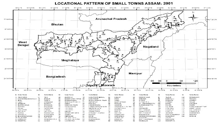
For the study of distribution of small towns the grid map is studied with the help of total 128 equal grids made in the interval of 30 minutes latitude and longitude. In this study of Small towns present uneven distribution pattern of towns, which implies that some of the towns were either sparsely distributed or were crowdedly. While sparsely distributed grids confined mostly to the border areas, surrounded by less urbanized states of India namely, Nagaland, Arunachal Pradesh, and Meghalaya.
IJSER
Figure 3 Locational Pattern of Small towns Assam, 2001
IJSER © 2013 http://www.ijser.org
International Journal of Scientific & Engineering Research, Volume 4, Issue 12, December-2013 1147
ISSN 2229-5518
As revealed in the Figure 3 the distribution of small towns in Assam seems to be quite uneven highlighting the following facts:
Towns are distributed in the grid/zone as a group of 3, 4,5,6,7 a good number of grids has shown single town in it.There are nine numbers of zone of maximum concentration i.e. the group of 6-7 towns which falls under the grid of 12, 13, 16, 19, 21,22 and 23,24 and 34 namely, Guwahati, Sualkuchi, Palasbari,North Guwahati, Abhaiyapuri, Bongaigaon, Rangia, Kokrajhar, Pathsala,Barpeta, Silchar, Tinsukia,Nagaon, Namrup, Jorhat, Dibrugarh. Guwahati being the lone city give impetus to the growth of small towns in its proximity. The towns along the River Brahamaputra form almost a linear pattern under the grid of 28, 2, 10, 112, 124, 79, 51, 59, 106, 43, 44, 42, and 108. Digboi Oil Town in the grid 12 as petroleum based industrial town contribute to the growth of small towns in and around it. New Bongaigoan town both as Oil town and as a railway junction helps in the growth of small towns near it. In grid 34 lies the Silchar town, the city is constantly witnessing a huge influx of people from nearby smaller places due to increasing future prospects and other developments in the field of education, medical facilities and the more recently booming real estate market and other commercial enterprises. No towns are located in the grid of 120, 71, and 74. The grids of 13, 27,108, and 39 have single town each.
IJSER
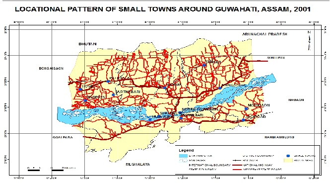
Figure 4 Locational Pattern of Small Towns around Guwahati City Assam, 2001
IJSER © 2013 http://www.ijser.org
International Journal of Scientific & Engineering Research, Volume 4, Issue 12, December-2013 1148
ISSN 2229-5518
For the study region the grid map is studied by the help of total 54 equal grids made in the interval of 15 minutes latitude and longitude for the surrounding small towns of Guwahati city. In the Figure 4 the distribution of surrounding small towns of Guwahati city seems to be quite uneven highlighting the following facts:
Towns are distributed in the grid/zone as a group of 1, 2, 3, 7 a good number of grids has shown single town in it. There is only one zone with maximum concentration i.e. the group of 7 towns which falls under the grid 32 and 33 are Guwahati, Sualkuchi, Bamun Sualkuchi, Dharapur, Kochpara, Palasbari, North Guwahati, and they are located in Kamrup district. The towns form linear and a scattered pattern in the grid of 21, 22, 23, 15 and 16. No towns are located in the grid of 38, 39, 40 41 and 42 because of Meghalaya border and forest area. No towns are found in and along the Bhutan and Arunachal border areas in the grid of 2, 3, 4, 5, 6, 7, and 8.
SIZE CHARACTERISTICS OF THE SMALL TOWNS
It becomes clear from the above Table 8 that majority of small towns appears well in low to very low ‘size index’ and few with appreciable indices and that too due to absence of big cities in corresponding district. Total of 15 towns have low range of 1.5 size index, they are Rangia with 0.99, Sualkuchi with 0.56, Bamun Sualkuchi with o.28, Palasbari with 0.22, Kochpara with 0.30, North Guwahati with 0.64, Chandrapur with 0.29, Howli with 1.01, Sarbhog with 0.46, Bohari with 0.49, Pathsala with 0.60, Tihu with 0.37, Sarthebari with 0.46, and Tangla with 1.2 size index. 8 towns namely, Nalbari, Kharupetia, Udalguri, Jagiroad, Marigaon, Barpeta Road, Barpeta, and Mangaldoi with 2.01,
1.18, 1.96, 2.21, 2.68, 2.16, 2.49 and 1.59 size index respectively. The town with high size index of 32.46 is Guwahati city.
Table 8 Size Index of Small Towns in the Study Region, 2001
IJSER
Data Source: - Census of India, 2001 Town Directory
CONCLUSION:-
In the context of growth of small towns in the surroundings of Guwahati city following conclusions emerge:
• Three distinct periods of growth of Guwahati city and the surrounding small towns namely, stagnant, slow and high are found based on decadal growth of towns for a period of 1901-2001.
• Growth indices of pre- independence period during various decades show the trend of relegating
growth while the figures of post- independence period point to promising growth indices. However in post-independence period in 1971-81 shows stagnant growth as social unrest prevailed all over the Assam and Census was not conducted.
• Spatial distribution of small towns in the study region reveals unevenness, linear and scattered in pattern and high concentration around the Guwahati city and its absence in and along the border areas.
• The percentage share of urban population in the study region in 1971 was 26.3 percent, followed by
35.3 percent in 1991 and 32.5 percent in 2001. The trend of urbanisation in the study region is found to be remarkably high as compared to the situation of Assam. In 1971 it was 9.25 percent, followed by 11.7 percent in 1991 and 12.9 percent in 2001. The gap between urbanisation level of Assam and the study region widened during 1971 in the gap of 23.6 percentage points. In 2001 the gap was
IJSER © 2013 http://www.ijser.org
International Journal of Scientific & Engineering Research, Volume 4, Issue 12, December-2013 1149
ISSN 2229-5518
19.64 percentage points. This gap justify, that urbanisation is more concentrated in the study region.
• The high level of urbanisation in the study region is due to the dominance of the lone Class-I city
i.e Guwahati. The city alone accounted 69.6 percent reflecting high concentration of urban population. The faster demographic growth is an important factor for the increase in the percentage share of urban population in Guwahati city and also greater employment opportunities lead to inter and intra state migration of population across the country.
ACKNOWLEDGEMENT:
I acknowledge University Grants Commission (UGC) New Delhi, for awarding me Rajiv Gandhi National Doctoral Fellowship for the financial support. I offer my sincerest gratitude to Dr. Jnanashree Bora, and Dr. Jayashree Borah, my guide and supervisor.
REFERENCES:-
A. Das. Urban Planning in India, Rawat Publications, New Delhi- 2, 2007
A. Dubey. “Poverty and occupational structure in size class of towns in India”, Regional Development Dialogue 1999
A. Kundu. “Trends and Structure of Employment in the 1990s: Implication for Urban Growth “, Economic and
Political Weekly, 32 (4): 1399-1405, 1997
Census, Town DirectIory AssJam, 2001 SER
Census, Town Directory Assam, 1991, Series-4
D. Mahadevia, Urban Policies in India—Critical Overview Towards Agenda in the New Millennium, paper presented at the National Workshop on Urban Agenda in the New Millennium, School of Planning, Centre for Environmental Planning and Technology and UNNATI, supported by Oxfam (India) Trust, Ahmedabad, 1999
K.Singh. Small and Medium Towns -A Geographical Perspective, Rajat Publications, New Delhi, 2006
K.C. Shivaramakrishna, Handbook of Urbanisation in India, Oxford University, Press, New Delhi, 2005
McKinsey Global Institute, India’s Urban awakening: Building inclusive cities, sustaining economic growth, 2010
R.C. Chandna, Population Growth of Indian Cities, 1970-71, Asian Profile, vol.4 No.1, pp 35-53 1976
R.P. Mishra Regional Planning Concepts, Techniques, Policies and Case studies, Concept Publishing Company New
Delhi-59, 2002
S. Mukherjee. Low Quality Migration in India: The Phenomena of Distressed Migration and Acute Urban Decay, paper presented at the 24th Iussp Conference, Salvador, Brazil, 1995
U. C. Mallic, "A Profile of India's Urbanization: Problem and Policy Issues", In Gopal Bharagava (Eds), Urban
Problems and Policy Perspectives, Abhinav Publications, New Delhi, 1981
V.N. Jha, ‘Small Towns and Regional Development’, Rajesh Publications, New Delhi, pp. 29, 2006.
Authors Detail:
IJSER © 2013 http://www.ijser.org
International Journal of Scientific & Engineering Research, Volume 4, Issue 12, December-2013 1150
ISSN 2229-5518
*Ms. Rinku Manta Research Scholar, Deptt. Of Geography Guwahati University Assam
**Dr. Jnanshree Borah, Associate Professor, Deptt. Of Geography Arya Vidyapeeth College
***Dr.Jayashree Bora, Associate Professor, Deptt. Of Geography, Cotton College Guwahati.
-------------------------------- X --------------------------------------
IJSER
IJSER © 2013 http://www.ijser.org