International Journal of Scientific & Engineering Research, Volume 5, Issue 1, January-2014 6
ISSN 2229-5518
GIS based Real time municipality management
system (RTMMS)
Dr.Sajid Rashid ahmad, Sana khushi, Muhammad Atif But
Abstract— This paper is built on GIS based Real Time Municipality Management System (RTMMS). RTMMS is used for analysis of Municipality Management issues, like solid waste, water drainage situation, waste disposal, recycling and many more. It is the need of the time to improve municipality system through proper planning and management which is possible by using RTMMS. GIS is integrated successfully as the management tool in every sector and also in municipality management issues. The focus of this topic is to only check that how much RTMMS is effective for visualization of water drainage situation in the area of Lahore and how much beneficial for the decision making process.
Index Terms— RTMMS (Real time Municipality management system), Municipal management, Geographical information system, Participatory GIS
1 INTRODUCTION
—————————— ——————————
Successful design and implementation of the RTMMS for the e-participation requires the functional requirement,
The municipal management situation of most cities of the
developing world is very unsatisfactory. More attempts are
needed to be taken for handling the spatial
context/situation in order to improve the decision making
technology, and operation.
2 PROBLEMS IN CURRENT SYSTEM
Different departments in the local government manage all
IJSER
process. Usually is the responsibility of the government
(local government, provisional government, and some time
federal government) or the private companies to ensure the
service is provided according to the standard. To reduce the gap between government and citizens in, an informative
and collaborative system need to be develop that create the particularity environment. These issues may be resolved through the web based participatory planning practice. Good decisions are the best composition of good
information. Public meeting is one of the major means of improving public participation. The rapidly expanding range of Web technology has made it possible to collaboratively make decisions over the Web [5]
Municipal planning and development is an important and
complex decision making practice for every local/municipal government [3]. Public participation relies on efficient notification participation and feedback.
GIS is the tool that is effective to support decision making process in the municipality. It is also likely that GIS use will extend beyond mapping, towards a richer use of its spatial analytical capabilities [1].Geo-collaboration as a Group of individuals working together to solve Geographic problems facilitated by geospatial technologies. Geo Collaboration
can be seen as any collaborative (i.e. two or more users)
activity supported through the use of geo information
technologies [2]
The municipal management based on real-time system is used for city municipality planning. RTMMS find the ways in which the common men, relevant authorities and managerial level team take part through web access.
through planning. Departments take any decision based on
the provided information. Unluckily in Pakistan information processing is very slow for resolving any of the issue. The situation is that even the high authorities do not get information about the issue from their own staff on
time. Existing system is difficult to follow, not interactive
and platform independent. Current municipalities are unable to response public in time. Public participation or input is slightly limited during the existing approaches of the municipal planning process. So the need of the time is to accelerate the flow of information through the technology, mobile service, people participation, location
identification, geo-tagging, and the communication through the internet sources.
3 DEPARTMENTAL COORDINATION AND PUBLIC INVOLVEMENT
The coordination between departments may be facilitated
for better management. For same tasks of the same
geographical area different departments work and these
departments are run by different authorities ([6]. Old
system in which departments involve public/citizen for their value suggestion to improve the system shows in below figure 1. Like before that technology citizen participate in the municipal system through open houses, direct mail opinion survey, awareness meeting, telephonic enquires off and on. When the problem comes in daily routine, long procedure to inform the relevant authorities but after that these manual system assume to be change for fasten government process.
IJSER © 2014 http://www.ijser.org
International Journal of Scientific & Engineering Research, Volume 5, Issue 1, January-2014 7
ISSN 2229-5518
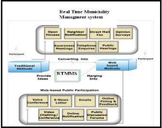
Figure 1: Traditional methods into web-based methods
In figure 1[11] RTMMS convert all the manual and slow process in to electronic ways. Lack of coordination may cause time wastage and sometimes resource wastage. That’s why municipalities are developing database,
management system. It is not possible unless the data is
5 DESIGN AND WORKING ENVIRONMENT OF THE
RTMMS
RTMMS makes possible e-participation of the users in the same GIS framework. RTMMS helps in data exploration and works as decision making tool for e-participators at different locations. It is a complete web-based solution and more beneficial than the desktop GIS Technology. The spatial based discussion leads for the online planning [8],[9].
RTMMS is the multi functionality GIS based Collaborative participation System. This integrate the different information technology tools to support the e-participation while the meeting. New technologies have emerged to
Help citizens have a more active role in public service delivery [4]. During the meeting and after the meeting it receives feedback, remote user input and collaborative output for the decision making. RTMMS provides the support in following two forms:
1) Asynchronous RTMMS user participation that supports any time web based discussion and input.
2) Real time collaboration and GIS process that apply on
IJSER
interconnected in all departments. The system will be
updated because the functions change at daily basis. Before the RTMMS, government involve the public through the survey, direct mail, open house discussion, awareness meeting, telephone inquiries, public hiring, after the Real time technology involved in the system change the open house survey into voice conference, neighborhood notification into E-news letter, direct mail fax into Emails and similarly all other function convert in to the real time quick respond system.
4 AIMS AND OBJECTIVES OF THE RTMMS MODEL
• RTMMS is developed with the help of open source technologies.
• RTMMS can address the data sources and users who are part of participatory GIS.
• It locates where the remote user identify the problem, kind of problem, and the source of problem. It cans highlights concerning municipality, outcome of the effective process by the municipal authorities.
• Different users access the RTMMS platform and visualize the working frame. This clears the efficiency situation what has to be done and what is going on.
• RTMMS plays important role to improve the quality of the current work and produce the output that’s not clear before.
the digital tools to share and explore spatial data.
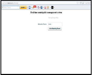
Figure 2: RTMMS User interface for login system
The figure 3 is the projected information center to manage and provide the public and all group users the RTMMS access, the information related to the ongoing participatory meeting for the municipality management planning, get the public share information, meeting output, and all the finding in the result of the meeting. Spatial data model represents the reality already mapped and stored through
IJSER © 2014 http://www.ijser.org
International Journal of Scientific & Engineering Research, Volume 5, Issue 1, January-2014 8
ISSN 2229-5518
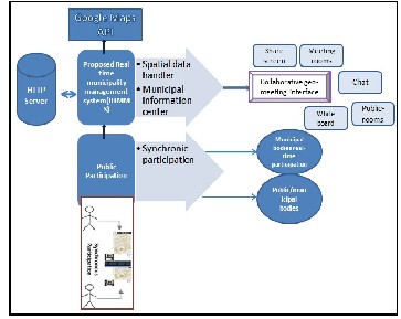
the geo database. Every time user participates and identifies the area to discuss the model store and generate
The layer according the date and time and other attributes as shown in fig.3.
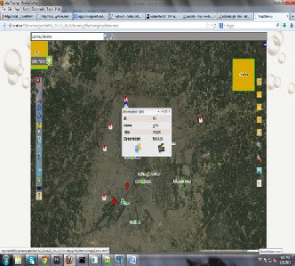
Figure 4: Inner working structure of RTMMS
screen, white board discussion, spatial information,
meeting rooms, map Navigation etc. are shown in fig.4.
6 ADVANTAGES AND LIMITATIONS OF RTMMS
1. Time and cost save in administration
2. Support in efficient planning and decision making
3. Spatial data base support and updating.
4. Managed data without any redundancy.
5. Coordination among department.
6. Public response on any departmental action, area
base participation
7. Analysis capability
8. Informed decisions timely.
7 RESULT AND DISCUSSIONS
Figure 3: RTMMS working environment.
RTMMS generate the integrated system which enables the spatially referenced data management. Department’s participation will be possible to preserve the current functionality. Only the RTMMS model will plan to ensure the data compatibility. Each layer captures spatial data information and attribute data is stored as parallel but the interconnection between data bases is defined. A part of autonomy created under the RTMMS that maintain the databases on the local computing system. GIS functionality in RTMMS enables the integration of the spatial and attributes data compatibility. RTMMS structure need the data capability and updating time to time. This is the created structure that will speed up the system development and record updating process. Main feature in RTMMS model include map sharing, geo-tagging, share
This study introduces collaborative methods to encourage participation approaches that support public involvement during the municipal planning and decision-making process. Through web based collaboration Geoconference can greatly improve coordination during an emergency situation [7]. Maps play an important part for displaying and Receiving geo-referenced, user-added content [10]. RTMMS model will improve the public participation and municipal team participation for resolving issue related municipality and more effective planning. Reduce the gap between the general public and municipal authorities. By the RTMMS the spatial data access is possible at anytime, anywhere using web-link. Furthermore, it makes possible to provide a virtual platform for spatial discussion related to municipality management to all users, who can access the prototype interface from their work with its functionalities i.e., convenient web based mapping, maps co-browsing, seminar recording, video streaming, easy project documents sharing, and screen sharing. The
motivation for making this application available online was
IJSER © 2014 http://www.ijser.org
International Journal of Scientific & Engineering Research, Volume 5, Issue 1, January-2014 9
ISSN 2229-5518
drawn from the wider public access to data and tools for spatial planning and decision-making. [10]
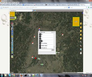
Figure.5: RTMMS Public spatial based discussion.
RTMMS is also used to check how the local government staff and other higher authorities handle the citizen
complaints regarding the municipal service and make it
issues. Although a prototype (RTMMS) as a proof of concept is designed and developed based on a GIS-based public participatory framework, but still face some social and implementation issues which need to be more studied and resolved, and test according to the real world scenarios. In fig.5 shows the spatial based discussion at the Lahore city. Many users can take part in any notified area at a time and making this process faster. The overall decision making process will be collaborative and improved. Real time monitoring system can be used by Election Commission of Pakistan and should be implemented in Local Government Elections.
8 CONCLUSIONS:
For this research the need to develop a system for management of the issue regarding municipality. It is an integrated system that models the requirement of the user for the management process. It smoothen response the public, authorizes and the management people of municipalities. This tool provided the user friendly graphical interface; effective communication channel and data privacy protection. It would be successfully improve the response from the municipal officials and batter
communication for the decision makers.
possible for the quick respond. RTMMS make sure the quick accessibility to the user for the municipality related
REFERENCES
[1] A. Zergera, D.I. Smith. “Impediments to using GIS for real-time disaster decision support”. Computers, Environment and Urban Systems ,pp. 123–141,2003
[2] M. Bortenschlager, S. Leitinger, H. Rieser, R. Steinmann.”Geo-
collaboration and P2P Geographic Information Systems” Florian Probst and Carsten Keßler (Eds.). pp. 167-172, 2007 - Young Researchers Forum. IfGIprints 30. ISBN: 978-3-936616-48-4.
[3] A. Evans, R. Kingston, S. Carver, I.Turton.”Web-based GIS used to enhance public democratic involvement”. Geocomp’99 Conference Proceedings, Mary Washington College, Virginia, USA. 1999. Avaialable at : http://www.geog.leeds.ac.uk/papers/99-1/
[4] J. Zhao, D. Coleman. “An Empirical Assessment of a Web-based
PPGIS Prototype”. 2007.
[5] M.A Butt, S. Li, “Open source based online map sharing to support real time collaboration”. OSGeo Journal Volume 10, pp. 4-15, 2012.
[6] R. Maggio. “A GIS-Based Municipal Information Management System as an Integrated Approach to the Management of Urban Data Bases”. EGIS.1994.
[7] O. E. Nelson, N. Siriwardanegea, A. Gryszkiewicz, Dr. F. Chen.
”Concept for Intelligent Integrated System for Crisis Management”.
Proceedings of the 7th International ISCRAM Conference. Seattle, USA.2010
[8] C. Rinner. “Web-based Spatial Decision Support: Status and
Research Directions”. Geography Publications and Research, pp.14-
31, 2003.
[9] C. Rinner. “Argumentation maps: GIS-based discussion support for on-line planning”, Environment and Planning B: Planning and Design, Ph.D. Dissertation, University of Bonn, Germany.pp.847-
863, 2001.
[10] S. Li, J. G. Mashup ”A New Way of Providing Web Mapping/GIS Services”. The International Archives of the Photogrammetry, Remote Sensing and Spatial Information Sciences, Vol. XXXVII. Part B4. Beijing, pp. 639-648, 2008.
[11] S. Li, M.. A. .Butt “Developing a web-based, collaborative PPGIS
prototype”. Appl. Geomat. pp. 197-215, 2012
IJSER © 2014 http://www.ijser.org