International Journal of Scientific & Engineering Research, Volume 5, Issue 6, June-2014 4
ISSN 2229-5518
Efficient and Cost Effective Vehicle Tracking and Security System Using Global Positioning System
Kayode Francis Akingbade, Isiaka Ajewale Alimi, Daniel Oluwasheyi Olalekan
Abstract— The rate of vehicle theft all over the world is alarming and there is need to curb the act. There are different vehicle alarm and security systems with one or more limitations. In this paper, a low cost and efficient vehicle tracking and security system using Global Positioning System (GPS) is developed. The system consists of a hardware device (in-vehicle unit) installed in the vehicle to be tracked and a user/control phone. The device receives signal from the GPS satellites, send this data to the authorized user’s phone by Short Message Service (SMS) with the help of the Global System for Mobile communication (GSM) module placed in the device. The data that is been sent to the control phone is processed and fed into a Geographic information System (GIS) interface for the graphical location information display. The developed system also has the ability of stopping and starting the car by the connected relay when codes in form of SMS are sent to the in-vehicle unit from the authorized user of the system. The test results show that, the developed system is highly accurate and effective in determining location of vehicle and it is of high performance.
Index Terms— Geographic Information System, GPS, GSM Module, Mobile Station, SMS, Microcontroller
—————————— ——————————
HE need to nip in the bud the menace of vehicle theft in our society is of great importance all over the world. There are different vehicle alarm systems which when the alarm triggered, the owner could be alerted. Apart for the fact that these types of alarm systems are limited to certain dis- tance, the driver might not have the opportunity of setting other associated security measures that can prevent the vehicle from being stole when attacked at gun point. This shows that most of the conventional vehicle security systems are ineffec-
tive in handling advanced way of theft [1].
A vehicle tracking system is an electronic device installed in a vehicle to enable the owner or a third party to track the vehi- cle's location. There are technical terms that can be used that specify the ability to determine the location of a mobile station (MS) such as Geolocation, position location and radiolocation. By location, we mean the coordinates of the MS that may be two or three dimensional. This also comprises information such as the latitude and longitude where the MS is located [2]. There are certain companies that have the required technology in vehicle tracking but their subscribers have to pay for the services rendered monthly which make it highly expensive for majority to subscribe to. To this end, there is need for an effi- cient and cost effective vehicle tracking and security system. This paper presents a low cost vehicle tracking and security system that requires little or no maintenance. It can be operat- ed by the owner of the vehicle and there is no need for month- ly charges by the third party. The proposed system can trans- mit the location information of the vehicle when requested for or at certain pre-set period. Although the system can operate in real time but it is not implemented to save charges from service provider.
The device consists of a hardware device (In Vehicle Unit)
installed in the vehicle to be tracked and a user/control phone.
The device receives signal from the GPS satellites, send this data to the user’s phone by SMS with the help of the GSM module placed in the device. The data that is been sent to the user/control phone is processed and fed into a GIS interface (Google Map Application).
In Section 2, literature review on vehicle tracking system is discussed. Section 3 presents the system overview, design and methodology. Section 4 contains the performance evaluation, result and analysis. Conclusions are drawn in Section 5.
In a conventional vehicle tracking system, location is deter- mined the use of GPS. There is need for communication chan- nel from and to the control unit where location information can be access. The transmission mechanism could be a satel- lite, terrestrial radio or cellular connection. After capture, the tracking data can be transmitted using any choice of telemetry or wireless communications systems. GSM is the most com- mon used service for this purpose. The received data by the control phone can be processed and fed into a GIS interface [3].
The Global Positioning System (GPS) is a space-based global navigation satellite system that provides reliable location and time information in all weather and at all times and anywhere on or near the Earth when and where there is an unobstructed line of sight to four or more GPS satellites. It is maintained by the United States government and is freely accessible by any- one with a GPS receiver. GPS consists of a network of 24 satel- lites in six different 12-hour orbital paths spaced so that at least five are in view from every point on the globe [4].
IJSER © 2013 http://www.ijser.org
International Journal of Scientific & Engineering Research, Volume 5, Issue 6, June-2014 5
ISSN 2229-5518
A geographic information system (GIS) is any system that cap- tures, stores, analyses, manages, and presents data that are linked to location. In the simplest terms, GIS is the merging of cartography, statistical analysis, and database technology. GIS systems are used in systems such as cartography, remote sens- ing, navigation, and localised search engines [2, 5].
Microcontrollers are mini computers on a single integrated circuit containing a processor core, memory, and programma- ble input/output peripherals. They are designed for embed- ded applications, and also used for automatically controlled devices [4, 6].
A GSM module is a wireless module that works with a GSM wireless network. A wireless module behaves like a dial- up module. The main difference between them is that a dial- up module sends and receives data through a fixed telephone line while a wireless module sends and receives data through radio waves [3, 7]. GSM module is connected to a computer through a serial cable or a USB cable.
The tracking device is installed in a vehicle, and has the capa- bility to receive both GPS and GSM signals via GPS receiver and GSM module respectively. The GPS receiver gets the exact current position of the vehicle in form of longitudinal and lati- tudinal coordinates from any four visible satellites among the constellation in the orbit [2, 8]. These positional data is then displayed on the device’s LCD and sent to the control/user phone in form of SMS via a communication network when it is been requested for, this interaction is possible because of the GSM module in tracking device. The tracking device is trig- gered when a specified SMS is received requesting its current location information.
Furthermore, the relay on the tracking device could be de- energized by an SMS from the control phone thereby cutting off the flow of fuel from the vehicle hence the vehicle stops when it has been confirmed that there is a theft. The device confirms this action by sending a confirmatory ‘CAR OFF’ text to the control phone. To energise the relay again an SMS from the control phone will enable flow of fuel and the vehicle can operate again. The device also confirms this action by sending a confirmatory ‘CAR ON’ text to the control phone.
————————————————
• Kayode Francis Akingbade is a lecturer in Electrical and Electronics Engi- neering Department in Federal University of Technology, Akure, Nigeria, PH-+234-(0)-8035667431. E-mail: kfakingbade@futa.edu.ng
• Isiaka Ajewale Alimi is currently pursuing Ph .D. degree program in Elec-
trical and Electronics Engineering in Federal University of Technology, Akure, Nigeria, PH-+234-(0)-8034399281. E-mail:
• Daniel Oluwasheyi Olalekan graduated in 2010 in Electrical and Electron-
ics Engineering in Federal University of Technology, Akure, Nigeria.
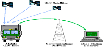
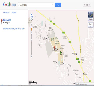
The positional data gotten from the tracking device is been converted to degree-minutes-seconds (DD MM SS) by a MATLAB program and this is been fed into a Google map application where the vehicle exact position can be viewed. The system is illustrated in fig. 1.
The GPS module used for this work is the ME2530A mod- ule. It is an antenna-less receiver and it is employed because it does not require an external GPS antenna. Its in-built antenna makes the tracking device more reliable and compact. The microcontroller used is the ATmega16. Two of these microcon- trollers are interfaced together. In this vehicle tracking, the embedded microcontroller is programmed to be able to read and interpret SMS been sent to it by a phone or a GSM module in form of codes.
The GSM module serves as the communication link be- tween the GPS vehicle tracker and the control phone. It com- municates by sending SMS to the control phone and also acts as a recipient in receiving SMS from the control’s phone. The GSM module in the system comprises of a SIM slot, where a SIM card is inserted; an antenna, for reception and a serial I/O port: for connecting to other serial devices as well as pro- gramming. In this project the GIS used is the Google Map Ap- plication which translates the longitudinal and longitudinal coordinates into pictorial view. The major components here include; two microcontrollers (ATmega16), GSM module, GPS receiver.
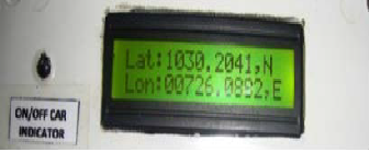
The tracker works effectively when energised for operation. The device loads for some seconds while it tries to receive and read the GPS signal. After connection with the GPS has been established, the device reads the information and displays its current position on the screen. This is shown in plate 1. The tracker current location is shows in longitudinal and latitudi- nal coordinates.
IJSER © 2013 http://www.ijser.org
International Journal of Scientific & Engineering Research, Volume 5, Issue 6, June-2014 6
ISSN 2229-5518
When the tracker passes the initialization stage of retrieving and reading the GPS signal it sends a message to the control phone prompting the user on what to do. The message con- tains the command code that the device recognizes. The con- trol phone used for the project was a Blackberry Curve 3 phone. Although other phones can be used as the control phone because it functions with the mobile number of the SIM card which has been included in the source code. Plate 2 shows the format the SMS sent to the control’s phone.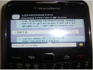
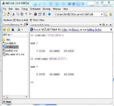
After getting the converted positional coordinates, it is insert- ed in Google Map as shown in figure 3. The converted latitude value in DD’MM’SS which is usually three separate values e.g.
From plate 2, messages like “Car Tracking System Ready: send DATA to get location, CAR OFF to disable the car, CAR ON to enable car” are received by the control phone. When “DATA” is sent to the tracker’s number, the exact posi- tion of the device present location is returned to the control phone as:
Although these are positional coordinates, they are in degree- minutes (DD’MMMM) form, but the GIS employed, GOOGLE MAP API, only recognizes coordinates in degree-minute- second (DD’MM’SS). A MATLAB code is written to do the conversion. A function was written on MATLAB with the M- file. The function for converting the longitude was named CONVLONG that for latitude CONVLAT. The MATLAB in- terface converting the longitude and latitude is shown in fig. 2.
IJSER © 2013 http://www.ijser.org
International Journal of Scientific & Engineering Research, Volume 5, Issue 6, June-2014 7
ISSN 2229-5518
Vehicle tracking system is becoming increasingly essential all over the world because of alarming theft rate. The paper presents a highly accurate yet inexpensive and effective vehi- cle tracking and security system using GPS that could be used to track and protect any remote vehicle equipped with the In- Vehicle Unit. The system consists of the In-Vehicle Unit and a Control Phone. The location information is transmitted to au- thorized user’s control phone using GSM modem on GSM network by using SMS. The control phone also has GSM mo- dem that receives vehicle location information via GSM net- work. When it has been confirmed that there is a theft an SMS from the control phone cuts the engine of the remote vehicle by stopping the flow of fuel hence the vehicle stops. The re- sults presented in this paper contain execution of startup rou- tine, logs of the control phone, converted position coordinates and GIS map of the current location of the vehicle. Perfor- mance evaluation of the system shows effective operation.
[1] [1] A. S. Dinkar and S.A Shaikh, “Design and Implementation of Vehicle Tracking System Using GPS,” Journal of Information Engineering and Appli- cations, vol. 1, no. 3, pp. 1-7, 2011
[2] [2] D. Bajaj and N. Gupta, “GPS Based Automatic Vehicle Tracking Using
RFID,” International Journal of Engineering and Innovative Technology, vol.
1, issue 1, pp. 31-35, 2012.
[3] [3] B. Kodavati, V. K. Raju, S. S. Rao, A. V. Prabu, T. A. Rao and Y. V. Na-
rayana, “GSM and GPS Based Vehicle Location and Tracking System,” Inter- national Journal of Engineering Research and Applications, vol. 1, issue 3, pp.
616-625, 2011.
[4] [4] K. Maurya, M. Singh and N. Jain, “Real Time Vehicle Tracking System
using GSM and GPS Technology- An Anti-theft Tracking System,” Interna- tional Journal of Electronics and Computer Science Engineering, vol. 1, no. 3, pp. 1103-1107, 2010.
[5]
[6] [5] K. B. Alison (2007) “Global positioning System: World Book Encyclo- paedia” vol.8 world book, 2002 edition.
[7] [6] P. R. M. Muruganandham, “Real Time Web based Vehicle Tracking using GPS,” World Academy of Science, Engineering and Technology, pp. 91-
99, 2010.
[8] [7] A. Thangavelu, “Location Identification and Vehicle Tracking Using
VANET,” pp. 112-116. 2007.
[9] [8] J. Kamal and G. Rahul, “GPS Based Low Cost Intelligent Vehicle Track- ing System (IVTS),” International Conference on Traffic and Transportation Engineering, vol. 26, no. 1, pp. 93-97, 2012.
IJSER © 2013 http://www.ijser.org