International Journal of Scientific & Engineering Research, Volume 6, Issue 2, February-2015 726
ISSN 2229-5518
Exploration and Application of Geothermal
Energy in Nigeria
Ikechukwu ikeagwuani .O, Derick C. Agbidi, Olusola O. Bamisile
Department of Energy Systems Engineering, Cyprus International University,
Haspolat-Lefkosa, Via Mersin 10, Turkey
Abstract- Consumption of hydroelectricity and fossil fuel have had a controlling impact on levels of investigation and improvement for geothermal energy assets in Nigeria for the past a few years. The center of improvement has been in the regions of low temperature geothermal energy including the investigation and appraisal of hot spring assets essentially for recreational applications, which could as well be used to curb electricity problem in Nigeria. Sedimentary basins in Nigeria have been investigated for hydrocarbons for a few decades, subsequently the oil organizations gathered substantial subsurface temperature information premise. Anyhow very little is thought about geothermal conditions inside Nigerian Precambrian crystalline region. On the premise of BHT information from oil wells it has been observed that geothermal angle in Niger Delta ranges from 1.5 to 4.9°c/100m and in Anambra Basin (specifically to the north) it can achieve 5.7°c/100m. Investigation for geothermal energy in northern Nigeria focused around shoal water wells (down to 600 m profound) was completed in excess of 20 years back. The other part of geothermal investigation in Nigeria is researching of the warm springs and drainages, which happen mostly inside dregs of the Middle and Upper Benue Trough. The water of the hottest springs around there: Akiri and RuwanZafi have the temperature around
56°c. There are most likely just three geothermal energy locations in Nigeria. The Ikogosi warm spring (37°c) placed in south-western piece of the nation, in Ekiti state, the W ikki warm spring (39°c) spotted in Bauchi (North-eastern) a piece of Nigeria and the RafinRewa spring (42°c) found in Plateau (North-focal) condition of Nigeria. However, this paper surveys the current status of the geothermal, exploration, exploitation and application in Nigeria.
1. INTRODUCTION
Basically, geothermal energy involves the taping of thermodynamic quantities that are equivalent to the capacity of a physical system to produce work or heat; from beneath the earth crust. Geothermal heat exists deep inside the earth’s interior and usually appears close to the earth’s surface through the means of conduction and convention.
The heat that emanates from the earth crust is as a result of the decay of radioactive isotopes of uranium, thorium, potassium and earth crust core which has a temperature of 1000-4500c.When this heat comes in contact with water it produces pressurized steam which is harnessed by proper application of adequate expertise, for the steam to turn a turbine for electricity to be produced. The magma coming in contact with underground water may not make the water pressurized but make it warm enough for spring spas.
The non-utilization/under-utilization of renewable energy resources such as geothermal resources is one of the causes of the insufficient supply of electricity generation and uneven electrical power distribution [9]. According to Nigerian electricity regulatory commission, currently Nigeria’s electrical production ranges between 3500-
4000Megawatts which far less than the current demand of 10,000Megawatts in the whole country [9,10]. Electricity
generated is from thermal and hydro power which constitutes of 66.7% and 33.3% of total power production respectively in the country [10]. Nigeria has a population of 180 million as at 2014 and only 40% has access to electricity; that is to show that the energy equity in the country is drastically poor [11].
Nigeria produces 120 million tons of oil per year and 4.39Mtoe of gas as reported by the world energy council website [11]. In as much as Nigeria produces much oil and gas it would be very true today that the greenhouse gasses produced in the country would be dangerously high. The idea of using renewable energy in the country should be greatly encouraged, since geothermal energy production uses very similar equipment and technology to that areused by the oil and gas industries. Therefore, it would be a very big advantage for Nigeria as a rich oil region to develop its geothermal resources [2].However, general problem within Nigerian energy sector made the authority to search for some other solutions, including the alternative sources of energy [4]. During the last decade, when the development in technology of renewable, clean energy use has been spreading worldwide [1], the awareness of energy sector as well as federal and local authorities about renewable energy raised also in Nigeria, this is evident from the Renewables
IJSER © 2015 http://www.ijser.org
International Journal of Scientific & Engineering Research, Volume 6, Issue 2, February-2015 727
ISSN 2229-5518
Energy Programme- Ministry of Environment, Federal Republic of Nigeria; on the list from their website Geothermal is fifth on the list of renewables to be implemented [7]. Presently, activity is concentrated mainly on possibilities of use of solar energy- since Nigeria is located in sub-Saharan West Africa which has high solar irradiance. There are also some plans about the use of wind energy and constructing a wind power plant, Micro Hydro-Energy, Biomass & Biofuel.
Moves to install geothermal plants have not been widely known in Nigeria, but documented investigations of subsurface temperature of rock mass has been carried out in hundreds of wells ,due to exploration for oil and gas within sedimentary basins [6]. There were several projects being aimed at exploration of subsurface temperature distribution, carried out with a use of data from oil and gas boreholes as well as shoal water wells. The results of those studies as well as investigation of geothermal surface manifestations give an idea about geothermal conditions of Nigeria.
2. OVERVIEW OF GEOTHERMAL POTENTIAL IN NIGERIA
The Nigerian Precambrian downstairs is uncovered on the land surface which is about 48% involving complete area of the land as well as remained 52% of the area is covered by Cretaceous to be able to new sediments deposited in several basins (Fig. 1). The downstairs room intricate of the main face shield, south-western portion, south-eastern as well as Asian border of the land contains 3 significant categories of crud:
- migmatite as well as gneiss dominated (Liberian to be able to Pan-African age).
- schists (metasediments) using quartzites as well as other minor lithologies being created prolonged, thin, north-south trending belts, primarily in the traditional western part of Nigeria as well as
- Invasive granitic crud – Older Granites (Late Precambrian to be able to First Palaeozoic age) as well as
Jurassic Younger Granites [12].
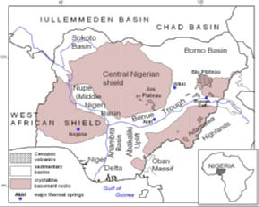
Figure 1: Geological setting and location of the major structural units in Nigeria [4].
The particular basins, seen were in some measure as troughs as well as rifts, were subjected to synsedimentary tectonic deformations throughout Cretaceus up to Neogene periods as well as suffering from magmatic – volcanic symptoms, that ended in current structural routine. The particular Niger Delta would be the deepest section of that significant Nigerian sedimentary belt as well as the maximal width involving sediments is greater than 9 kilometers generally there[17]. Benue Trough is subdivided in Reduced Benue Trough comprising Anambra Pot as well as Abakaliki Anticlinorium (Uplift), Center as well as Upper Benue Trough (together having Yola Supply, Gongola as well as Kerri Kerri basins) as well as the maximal width involving sediments reaches also 6 kilometers using some regions of the particular trough [15]. Inside north–east the particular Benue Trough is overlaid by means of sediments involving Nigerian section of Chad Pot referred to as Borno Pot, where the deepest component consists of several kilometers thick Cretaceous for you to Quaternary sediments [15] as well as in line with the different writers it could be more deeply (7 kilometers deeply in line width) [19]. The particular Sokoto Pot around the north-western borders involving Nigeria is a part of huge Iullemmeden Pot that runs considerably for the to the north. The particular Sokoto Pot maximal degree is approximately 1 kilometers around the north-western margin in the state [16] but also in the particular Niger as well as Mali terrain this is greater than 3 kilometers. The middle Niger Pot (Nupe or even Bida Basin), and that is only about 0. 5 -- 1 kilometres deeply with almost all of the region as well as won't meet or exceed
3 kilometers inside the deepest pieces [18] is usually a huge American side branch involving Benue Trough. Aside
IJSER © 2015 http://www.ijser.org
International Journal of Scientific & Engineering Research, Volume 6, Issue 2, February-2015 728
ISSN 2229-5518
from a couple of significant Nigerian provinces: Precambrian crystalline as well as Cretaceous for you to Quaternary sedimentary, your third kind of crud is present: Cainozoicvolcanic, largely inside the Japanese part of the state. The items involving Cainozoic magmatic as well as volcanic activity are usually quite a few trachyte-phonolitic as well as basaltic plugs in Benue Trough as well as basaltic lava plateaus via amid which the most notable are usually: Biu Level with its more than 80 volcanoes as well as intensive basaltic lava streams involving Jos Level [13, 14]. The particular geological construction in the regional impact on normal syndication involving geothermal warm inside the upper world crust as well as, for Nigeria, impact on geothermal search magnitude in every single geological land in the United States. There isn't very much identified about geothermal involving downstairs room crud mainly because those people locations don't have any oil potential so they are certainly not be subject to drilling search as well as subsurface temperatures dimensions. Sedimentary basins with Nigeria are actually investigated pertaining to hydrocarbons for a lot of ages, hence the particular acrylic corporations’ possess huge package involving subsurface temperatures data.Oil and gas search and digging water wells, are fantastic ways to obtain information regarding subsurface temperature is water boreholes[5]. The particular temperatures scored throughout growing testing is towards the true temperatures involving water bearing good ole' formation. However, like water wells are generally short, in particular water wells drilled in crystalline locations in Nigeria are certainly not more deeply than 20-30 meters considering that the water aquifers are usually in many instances positioned in delicate overburden overlying difficult crystalline good ole' size. Inside sedimentary locations water boreholes are generally more deeply, also because of 500m as well as some of them can be utilized for the reason that way to obtain geothermal data. Another way to obtain geothermal info is usually a area current expression involving geothermal activity. There are various warm as well as very hot spas as well as seepages tagging the particular parts of potential geothermal flaws with Nigeria, a lot of them situated in sedimentary container involving Benue Trough
The world normal high temperature stream in mainland Precambrian shields is around 41± 10 mw/m2 and such esteem is normal for Nigerian Precambrian storm cellar complex. Nonetheless, very little has been examined in that matter in Nigeria. The main broadly known hotness stream estimation was completed in the focal point of Ririwai ring complex being one of the granitic ring structures of Younger Granites Province of Northern Nigeria, spotted inside Precambrian shield. In the aftereffect of examination the normal hotness stream of 0.92±0.04 HFU (38.5±1.7 mw/m2) was acquired which is just about equivalent to the world average.in the South-western piece of Nigeria, the Ikogosi warm spring is found inside quartzite-schist development of Nigerian storm cellar complex. The spring water temperature is 37°c. It is utilized for swimming pool being a critical neighborhood vacation spot and likely the main spot of geothermal (immediate) use in Nigeria. There is an alternate warm spring simply found in RafinReewa, close Lere, to the North-west of Jos Plateau (focal shield). The temperature of spring water is 42°c and it spills out of magmatic and gneissic rock development (reported by M.l. Garba, ABU). A few springs have been shortly known in Jos Plateau and every one of them give cool, new water, normally utilized by nearby group. The recent application of spectral analysis to aeromagnetic anomalieswascarriedonIkogosi warm spring discovered that are is underlined by an average Curie point depth of 15 ± 0.6km which implies that a heat flow of 91.2 ± 2.1mW/m². The findings on Ikogosi warm spring opens grounds for proper exploitation of the geothermal resource in the area[8].
3.0 GEOTHERMAL EXPLORATION OF SOUTHERN SEDIMENTARY REGION
The subsurface temperature dispersion in the southern area, the Sedimentary Areas throughout Nigeria was analyzed through [20, 21] as well as Onuoha as well as Ekine [27]. They will employed remedied bottom hole temperature (BHT) files calculated throughout essential oil pursuit wells drilled throughout Niger Delta as well as Anambra basins. In accordance with [20, 21], studies the lowest ideals regarding geothermal gradient were being discovered in the center regarding Niger Delta from the heavy Tertiary sediments: 1, 3 – 1. 8°C/100m (Nwachukwu) or perhaps 2. 2 – 2. 6°C/100m throughout Warri- Dock Harcourt location [22]. The northward trend of gradient was detected which resulted in maximum value of 5.5ºC/100m in the location of Agwu-Enugu towns: and also within cretaceous rocks which contained coal beds in Anambara basin. The average values of geothermal gradient (2.9 -
4.7ºC/100m) was found along the coastal line in the south. Importantly, the geothermal gradients in the off shore parts of Niger Delta was calculated by Avbovbo were given to be 3.3-4.7ºC/100m [4].
However, recent research shows heterogeneousness in geothermal gradient in the Anambra basin. The values were calculated in 17 wells which ranged from 2.5 to 4.9 °C/100m and the heat flow estimated on the basis of these gradients was 48-76 mW/m2. In the research, the high temperature zone within Agwu-Enugu-Nsuka and constant trend of subsurface temperature increase from south towards the north was not confirmed.
3.1 GEOTHERMAL EXPLORATION CENTRAL AND NORTHERN SEDIMENTARY REGIONS
IJSER © 2015 http://www.ijser.org
International Journal of Scientific & Engineering Research, Volume 6, Issue 2, February-2015 729
ISSN 2229-5518
Geothermal qualities of the Bida (Nupe, Middle Niger) Basin and additionally Borno and Sokoto bowls was concentrated on the premise of warm information gathered amid pumping tests in water wells. These activities were carried out by [22, 23, 24, 25] (exploration on some piece of Iullemmeden Basin in Niger), all captained by K. Schoeneich. The water temperature information gathered in northern sedimentary bowls have been evaluated, rectified and utilized for gathering the guide of geothermal inclination indicated in Fig. 2 and 3. The temperature information from water wells 70m to 500 meters profound have been picked, in which temperatures were measured at the pump outlet with a mercury thermometer, following eight hours of pumping. The information from Borno Basin included likewise data structure a few profound oil wells. The information base and the guide demonstrates that temperature slope in Borno Basin ranges from 1.1 to 5.9°c/100m, in Sokoto Basin: 0.9 to 7.6 °c/100m, in this way in both cases the geothermal peculiarities are shown and plainly plotted on the guide. The zone of most astounding inclinations in Sokoto bowl is extended in SW-NE course, parallel to general strike of major sedimentary developments which are thin around there (around 200 m). This proposes that a critical wellspring of geothermal high temperature is spotted beneath sedimentary intricate, in Precambrian cellar and maybe is identified with some profound tectonic dynamic structure. The estimations of geothermal slopes found to the north of Nigeria, inside the other piece of Iullemmeden Basin in Niger, are considerably higher than in Sokoto Basin
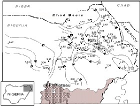
Figure 2: Map of geothermal slopes (°c/100m) inside the location of Chad (Borno) Basin [26].
There are not very many temperature information from Bida Basin and a significant number of the current ones were taken in extremely shallow water wells, however the most dependable estimations taken in more than 100m profound water wells demonstrate that in SE piece of the bowl the geothermal inclination is around 2-2.5 °c/100m. So far there are no any subsurface temperature information from Middle and Upper Benue Trough accessible for the creators, however the undertaking of taking estimations in water wells is in methodology now, as a subject of an ABU understudy work. By and by, it is extremely conceivable to discover geothermal peculiarities here on the grounds that they are showed in warm springs and drainages at the surface (for the area of some of them see Fig. 1). The springs in Middle Benue Trough stream from the Cretaceous, permeable sandstones, some of them are placed inside ranges popular from barite mining and customary salt creation focused around salty dregs. In such zone one of the most sweltering springs (53.5°c) is placed close Akiri, however the most acclaimed Nigerian warm spring is Wikki (32°c) spilling out of Gombe Sandstone in Yankari Game Reserve. An alternate hot one (54°c) is spotted in North of Benue Trough, inside a tremendous tectonic structure - Lamurde anticline, close by Numan and is called RuwanZafi. The water of the springs is warmed by geothermal angle on its path from obscure profundities, in unconfined sandstone aquifer [4].
IJSER © 2015 http://www.ijser.org
International Journal of Scientific & Engineering Research, Volume 6, Issue 2, February-2015 730
ISSN 2229-5518
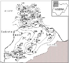
Figure 3: Map of geothermal gradients (°c/100m) inside the part of Iullemmeden basin [26].
Inside the Middle Benue Trough a few minor warm drainages were discovered close-by Awe where the temperature of the water ranges from 34 to 38.5°c. Warm water is given to the surface likewise by two artesian wells found around there. Temperatures of the water spilling out of those wells are 43.5°c and 34°c. They were bored toward the end of 1970s or start of 1980s and left for the neighborhood group as a wellspring of household water. Today the water is still uninhibitedly streaming there however the profundity of the wells and additionally gimmicks of the aquifer are obscure; penetrating documentation clearly does not exist.
4. APPLICATION OF GEOTHERMAL ENERGY IN NIGERIA
Nigeria is growing up as far as advancing the investigation of clean and renewable energy to serve as compliment to the national power framework. The Nigerian leaders accept and expect that the application of renewable energy would further fortify the advancement of Nigeria economically and encourage environmental sustainability. Highlighting the importance of geothermal energy, consideration of the country's energy blend, a Professor of Hydrogeology in the Ahmadu Bello University (abu), Zaria, Professor Krzyszstof Schoneich in a meeting debated for exploration into ideal methods for harnessing geothermal assets to create geothermal energy, with the endless supply of mineral assets in the country's mine resources.
Dr. NghargbuK'tso, the first Medical Geologist in Nigeria and presently a teacher in the Geology and Mining Department of the Nasarawa State University, Keffi, said harnessing geothermal energy would help Nigeria to climb above epileptic power supply issues which has been the situation for quite a while. He speculated that through global joint effort, he would help to extend the recently discovered field in the nation, through mindfulness creation, supporting for the foundation of a pilot Balneo Hospital in Awe, Nasarawa State and a mineral water packaging organization from RuwanZafi, Numan, in Adamawa State, generally as it is the situation with Benin Republic, Poland and different nations that have immeasurable bank of geological resources. Noting that constant power is needed to manage such activity, Nghargbu said: "Geothermal assets are copious in the north-eastern area of Nigeria and government can intercede to create control generally as it has finished with nearby generation of electricity from solar in Abuja, and arranged for coal plants in Kogi, Benue and the south-east. All these tasks of building a Balneo Hospital which will be utilizing geo-medical assets and the proposed mineral packaging water in the relative areas will need electricity to survive just with steady power, which geothermal energy can likewise give [3].
The Minister of Information (Nigeria), while embracing medicinal and environmental geology, guaranteed Nigerians that the new field would be created to enhance the expectations for everyday comforts saying, "Balneology is a new field in Nigeria and we accept that Nigeria would have the capacity to buy the idea; harness it and apply it for the soundness of our kin.
The Minister of Power (Nigeria), who is bent on accomplishing much power supply with an expansion to rustic regions in the country, noted that geothermal energy is the key. He had expressed that legislature is chipping away at
IJSER © 2015 http://www.ijser.org
International Journal of Scientific & Engineering Research, Volume 6, Issue 2, February-2015 731
ISSN 2229-5518
concocting a financial legitimate system that will make an empowering which would create an enabling environment for the renewable energy in the country. He said: "soon, we will be outfitting the president with a draft National Renewable Energy/Energy Conservation Policy for support." The draft of the current Renewable Energy arrangement ought to be returned to incorporate geothermal force era in its energy blend as it will help to advance a quality chain of maintainable power supply in urban and rustic regions.
More endeavors ought to be made by the Ministry to stimulate the Katsina wind task and the continuous probe half and half power supply engineering in the National Power Training Institute of Nigeria (NAPTIN) in Kainji, Niger State. Since geothermal-to-power energy activity has been utilized as a part of the United States and different nations to create noteworthy measure of power, Nigeria through private association could strive to create this in its energy blend as plentiful sources have been found along the Benue trough in Nasarawa and Benue states, Jos mining locales in level State, and the Borno basin in Borno State.
A fruitful trial of the geothermal energy extend in Nigeria may blend the required consolation for private speculators to enormously enter in into the current Public Private Partnership (PPP) activity which the Federal Government is supporting.
5. CONCLUSION
Conclusively, the regions of geothermal oddities with slopes over 5°c/100m found in the present study may be prospective for geothermal energy usage. In Nigeria the most required application of geothermal energy would be generation of power however the genuine probability of that and potential appraisal needs further research. The geothermal examination focused around geothermal inclinations demonstrated ranges of higher than normal slope values and geothermal inconsistencies inside sedimentary bowls. The impact of Cainozoic volcanic scenes on geothermal administration in the territory has not been researched yet. It is likely that warming impact of volcanic and meddlesome action on Cretaceous sedimentary bowls, exceptionally Benue Trough and additionally storm cellar intricate, helped the improvement of neighborhood peculiarities that can be discovered shortly. The more detail examination on warm springs ought to clarify the inception of hotness conveyed by the water to the surface and the profundity of water flow. It will give a thought regarding those common phenomena and help the investigation for potential outcomes of utilization of geothermal high temperature from both Sedimentary and Precambrian Regions in Nigeria.
It is pertinent to note that there is no direct application of geothermal energy in Nigeria for the production of electricity. Moves are on ground to facilitate the construction of geothermal plants in the nation.
REFERENCES
[1] OFOR. Ngozi. P* UDENSI. Emmanuel. E., Determination of the Heat Flow in the Sokoto Basin, Nigeria using Spectral Analysis of Aeromagnetic Data. Journal of Natural Sciences Research, ISSN 2224-3186 (Paper) ISSN 2225-0921 (Online) Vol.4, No.6, 2014.
[2] C.A Cole, “Review of geothermal heating and cooling of buildings,” 2nd climatic change technology conference.
[3] Renewables: Exploring geothermal for electrification 21january 2014 http://www.dailytrust.com.ng/daily/business/14855-renewables-exploring-geother mal-for-electrification
[4] Sedara, Samuel Omosule, Joshua,E.O. Evaluation of the Existing State of Geothermal Exploration and Development in
Nigeria Journal of Advances, Physics Journal of Advances in Physics 2013 vol 2, No 2 ISSN 2347-3487 page 118-123.
[5] Moumouni A., 2001. Groundwater temperature in AderDoutchi and environs, part of Iullemmeden Basin in Niger Republic.
Unpublished Master of Science thesis, Department of Geology, Ahmadu Bello University, Zaria, Nigeria.
[6] Obaje, N. G. (2009). „Geology and Mineral Resources of Nigeria‟ Nasarawa State University Dept. Geology and Mining
Keffi Nigeria.p.50.
[7] Renewable Energy programme. “Our focus .” . 13 December 2014. URLhttp://renewableenergy.gov.ng/invest/our- focus/geothermal/
[8] Ema Michael Abraham, KolawoleMuideenLawal, AmobiChigozieEkwe, Owens Alile, kehinde Ayofe Murana and Aminu Ahmed Lawal. Abraham et al. Spectral analysis of aeromagnetic data for geothermal energy investigation of Ikogosi warm spring - Ekitistate, southwestern Nigeria. Geothermal Energy 2014, 2:6 www.geother mal-energy-journal.com/content/2/1/6
IJSER © 2015 http://www.ijser.org
International Journal of Scientific & Engineering Research, Volume 6, Issue 2, February-2015 732
ISSN 2229-5518
[9] Olusola O. Bamisile. A Review of Solar Chimney Technology: Its’ Application to Desert Prone Villages/Regions in
Northern Nigeria, International Journal of Scientific & Engineering Research, Volume 5, Issue 12, December-2014 ISSN
2229-5518, Page 1210 – 1216.
[10] NERC: Nigerian Electricity Regulatory Commission (2014): http://www.nercng.org/index.php/document-library
[11] World energy council 2014: http://www.worldenergy.org/data/trilemma-index/country/nigeria/2014/
[12] Ajibade C. A., Woakes M., Rahaman M. A., 1989. Proterozoic Crustal Development in the Pan-African Regime of Nigeria.
In: Kogbe C. A. (ed.) Geology of Nigeria. 2nd Revised Edition, Abiprint&Pak Ltd., Ibadan.
[13] Grant N. K., Rex D. C., Freeth S. J., 1972. Potassium-Argon Ages and Strontium Isotope Ratio Measurements from Volcanic
Rocks in Northern Nigeria. Contr. Mineral and Petrol. 35, 277- 292.
[14] Turner D. C., 1978. Volcanoes of the Biu Basalt Plateau, Northeastern Nigeria. J. Mining and Geology, Vol. 15, No. 2, 49-63. [15] Benkhelil J., 1988. Structure et evolution geodynamique du basin intracontinental de la Benoue (Nigeria). Bulletin Centres
Recherchers Exploration-Production Elf- Aquitaine 12, pp 29-128.
[16] Kogbe C. A., 1979. Geology of the South Eastern (Sokoto) Sector of the Iullemmeden Basin. Bull. Dept. Geol., ABU, Zaria, Nigeria, Vol. 2, No. 1.
[17] Mattick R. E., 1982. Assesment of the petroleum, coal, and geothermal resources of the Economic Community of West
African States (ECOWAS) region. United States Department of the Interior Geological Survey.
[18] Ojo S. B., Ajakaiye D. E., 1989. Preliminary interpretation of Gravity Measurements in the Middle Niger Basin Area,
Nigeria. In: Kogbe C. A. (ed.) Geology of Nigeria. 2nd Revised Edition, Abiprint&Pak Ltd., Ibadan.
[19] Ostaficzuk S., 1996. Geo-ecology of the Nigerian Part of the Lake Chad Basin. University of Silesia Press, Katowice.
[20] Nwachukwu S. O., 1976. Approximate Geothermal Gradients in Niger Delta Sedimentary Basin. American Association of
Petroleum Geologists Bulletin, Vol. 60, No. 7, 1073-1077.
[21] Avbovbo A. A., 1978. Geothermal Gradients in the Southern Nigerian Basin. Bulletin of Canadian Petroleum Geology.
Vol.26, No.2, 268-274
[22] Haruna Y. A, 1990. Geothermal gradient of the Nupe basin. Unpublished Bachelor of Science thesis, Department of
Geography and Planning, Faculty of Environmental sciences, University of Jos, Nigeria.
[23] Olatunji S. A., 1989. Geothermal gradients and temperatures of ground water in Sokoto basin, Sokoto State, Nigeria.
Unpublished Master of Science thesis, Department of Geology, Ahmadu Bello University, Zaria, Nigeria.
[24] Moumouni A., 2001. Groundwater temperature in Ader- Doutchi and environs, part of Iullemmeden Basin in Niger Republic.
Unpublished Master of Science thesis, Department of Geology, Ahmadu Bello University, Zaria, Nigeria.
[25] Askira, M. T. (1987): Geopressured Aquifers and Geothermal Gradient in Borno State, Nigeria. Unpublished Master of
Science thesis, Department of Geology, Ahmadu Bello University, Zaria.
[26] Ewa Kurowska, Krzysztof Schoeneich, Geothermal Exploration in Nigeria. Proceedings World Geothermal Congress 2010
Bali, Indonesia, 25-29 April 2010.
[27] Onuch K. M., Ekine A. S., 1999. Subsurface temperature variation and heat flow in the Anambra Basin, Nigeria. Journal of
Africal Earth Sciences, Vol. 28, No. 3, 641- 652
IJSER © 2015 http://www.ijser.org