810-461 E longitude and 170-131 N latitude, and covers parts of the Survey of India topographic sheet numbers 65G/7, 8, 11, 12.
International Journal of Scientific & Engineering Research, Volume 6, Issue 2, February-2015 1291
ISSN 2229-5518
EIA for Ramapadasagar (Polavaram) Irrigation Project using Spatial Technology - few R&R Issues
*Dr.Y.Sreeramulu, 1Dr.I.V.Muralikrishna
*Professor, Department of Civil Engineering, KL University, Andhra Pradesh, India, Email:sreeramulu_civil@kluniversity.in
1Visiting Professor, Jackson State of University, USA, Email:ivm@gmail.com
Abstract
Development through displacement is part and parcel of the ongoing process of planned development. This Research study deals with the Spatial modeling of Environmental impact assessment for an irrigation project i.e.Ramapadasagar (Polavaram) Irrigation project, which has been carried out in parts of West Godavari, East Godavari and Khammam districts of Andhra Pradesh, India. About 14,400 Sq Kilometer area of remote sensing data have been collected and analyzed for environmental impact assessment by using emerging GIS technology. From the modeling analysis, the land use land cover environment, slope analysis are made. The model also conceptualizes sediment delivery from hydrologic unit into a reservoir as a multiplicative function of the potential soil detachment material (delivery ratio) and the area of the hydrologic entity. The Sediment yield index values are intended from the empirical model using for the sub watersheds and is varying from 1060 to 1500 and suggested Catchment area treatment. It has been pragmatic during water environment analysis, an area of about 50 sq.km is under inundation at low water level +135ft (41.15m), 200 sq.km is under inundation at +140ft (42.67m), and an area of 360 sq.km is under Inundation at +150ft (45.72m) FRL.
The involuntary displacement and resettlement often causes certain problems which have socio-economic and cultural implications. The objective of the paper is to understand and appreciate the nature and magnitude of social and economic risks of impoverishment being undergone by the project-affected tribal families in the event of their displacement. Impoverishment risk is examined with special reference to customary rights and privileges, land alienation and livelihood security. In the study area, it was found that many of the respondents were living in inaccessible areas that even lack minimum basic services and facilities. Even such situation leading to heavy losses do not voluntarily push them to move to safer places.
- R&R - Socio-economic and Cultural implications.
Environmental Impact Assessment define and assess the potential physical, biological, socio-economic and health effects of the proposed project in a manner that allows for a logical and rational decision to be made about the proposed action (Banham, W. and D. Brew, 1996) [5]. At Global level, various countries like India, U.S, U.K, China, Germany and Japan have experienced untold environmental degradation and ecological deterioration in the past century, with little or no real solution to allevia te many of these concerns. Poorly planned human interference has been the major cause. Adequate information and appropriate technology are limiting factors for effective environmental management. Because of the dynamic characteristics and multivariate nature of the environment, it has often been difficult to collate, analyze and interpret its data sets. However, this great complexity can be overcome with the present research of Engineering Management system Spatial Modeling of Remote sensing and Geographic Information System (GIS) and related technology with the ground truth verification. The prime objective is to study the environmental impact of the project on land use land cover environment, slope analysis, sediment yield, water environment ,submergence area and Resettlement and Rehabilitation issues
IJSER © 2015
International Journal of Scientific & Engineering Research, Volume 6, Issue 2, February-2015 1292
ISSN 2229-5518
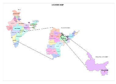
This study deals with Environmental impact assessment for developmental project i.e.Ramapada Sagar (Polavaram) Irrigation project, which has been carried out in parts of West Godavari, East Godavari and Khammam districts of Andhra Pradesh . The Godavari River originates in the Nasik district of Maharashtra, India and flows through West Godavari district of Andhra Pradesh, India and discharges directly into the Bay of Bengal Sea. The study area is represented in Figure 1.1, located between
810-461 E longitude and 170-131 N latitude, and covers parts of the Survey of India topographic sheet numbers 65G/7, 8, 11, 12.
The proposed project is a multipurpose project benefiting the upland areas of Visakhapatnam, East Godavari, West Godavari, Krishna and Khammam districts. It also supplies drinking water to Visakhapatnam township and villages enroute. The general climate of the command is characterized by hot summer and general dryness which gives copious rainfall. May is the hottest month with a maximum day temperature 440C and the minimum temperature is about 22° C. The south-west monsoon season during midst of June and ends by mid October. The annual average rainfall is about 858.65 mm. In the study area the humidity is very high during peak rainy season. Average wind velocity varies between 4.2 kmph in April and 8.47 kmph in November.The average rainfall in the command area is 859 mm.The finalized project site consists of a zoned Earth-cum-Rockfill dam with an impervious core across the existing river course. The spillway is located in the right flank saddle and power dam on the left flank saddle. The FRL of the reservoir is proposed as +150ft (45.72m).
IJSER © 2015
International Journal of Scientific & Engineering Research, Volume 6, Issue 2, February-2015 1293
ISSN 2229-5518

Probabilistic Risk Model of 2D - Graphical Longitudinal, Vertical Reservoir water quantity and quality model for EIA using RS & GIS
-Runoff based, - Regionalization of extreme flows
Stochastic Events
- Digital Elevation Map
- River Roughness, Flows, Depths,
Spotheights and velocities
- Water quantity , quality data and coefficients
- Physical data, cross section geometry , Elevations and locations of nodes; Lateral inflows and tributaries; Control Structures
- Water Quantity and
Quality targets at system control points
- 2D Analysis
Survey of India topographic sheets, Reconstruction of Historical Events
- By Return period
- District level
Reservoir water quantity
(Printed and / or plotted)
values for drinking and irrigation purposes
- Site selection for Resettlement & Rehabilitation purposes
IJSER © 2015
International Journal of Scientific & Engineering Research, Volume 6, Issue 2, February-2015 1294
ISSN 2229-5518
Probability Distributions:-
Generalized Pareto Distribution (GPD)
Cumulative Distribution Function when P [X ≤ x] , CDF F(x) = 1 – e –y where
Y = -K-1 log [1 – k (x - ξ ) / α ]
Y = ( x – ξ ) /α for k = 0
Generalized Extreme value distribution [GEV]
CDF , Fx (x) = exp { - [1 – (kx – ξ) /α ]1/k } for k ≠ 0
Fx (x) = exp { - exp[– (x – ξ) /α ] } for k = 0
Runoff Quantity Density Function = Derivative f(x) = d/dx [f (x)]
f(x) = d/dx (1-e-y)
= -d/dx {1-[k(x- ξ)/ α]}1/k
= 1/ α {1 – [k(x- ξ)/ α]}(1-k)/k
X f(x) | = = | Rainfall Runoff |
K | = | Slope factor / Velocity |
α | = | Time |
ξ | = | Infiltration |
Y | = | Runoff function coefficient |
The study utilised the Survey of India toposheets of 1:50,000 scale for studying the catchment area, command area and also the submergence area for identification of land use land cover, slope and soils, etc. The satellite based remote sensing imageries are procured from the NRSC, hyderabad for image analysis and arriving at the land use land cover, slope, soils, surface drainage, etc. and also for preparation of catchment area treatment plan based on Sediment Yield Index method.
This study is carried out by combining the features of satellite imagery, topographic sheets and secondary maps data to produce the necessary information layers of natural resources. The data translation into thematic maps employed the GIS software Arc/Info, Arc View , Arc Map and the remote sensing software ERDAS. The Impact is determined by taking the Spot heights as reference.
The following Figure 4.1, Figure 4.2 and Figure 4.3 are the output of Research work spatial model proposed:
IJSER © 2015
International Journal of Scientific & Engineering Research, Volume 6, Issue 2, February-2015 1295
ISSN 2229-5518
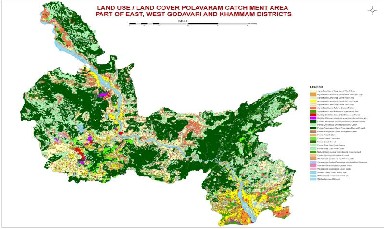
The analysis of remote sensing data provided the area under different land use and land cover under different categories of t he catchment and this area has been represented in Figure 4.1. The crop land covers 79.8% with an area of 3,92,766 ha, plantati ons
49,505ha, built up land occupies 23,262ha (4.72%), forest occupies a mere 0.38%, tanks and streams occupies 3,819 ha (0.82%)
and scrub land occupies 19,680ha (3.37%). The major soils in the command area are moderately deep gravelly sandy loams and lateritic upland (1,92,308 ha); followed by deep fine sandy loam (1,39,403 ha). The other types of soils are deep sandy loam on undulating land, moderately deep sandy loams on rolling lands, deep clayey soils on gently sloping, very deep fine loamy / clayey soils in valley, etc. The majority of the soil types fall in land irrigability/ classification 2 & 3.
International Journal of Scientific & Engineering Research, Volume 6, Issue 2, February-2015 1296
ISSN 2229-5518
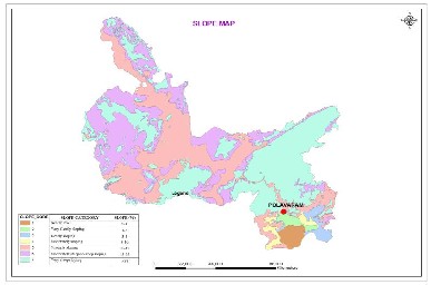
The slope map (Figure 4.2) has been prepared for the catchment areas using 1:50,000 scale topographical maps of Survey of India showing contours of 20 m interval using tan method. The different classes of slopes have been categorized as per the guidelines suggested by All India Soil and Land Use Survey (AIS&LUS). The vertical drop is measured from the contour interval and the horizontal distance between the contours is measured by multiplying the map distance with the scale factor. Finally the slope percentage is calculated. From the figure 4.2, the slopes of the catchment mostly range between 1% to 5% (i.e., nearly level to gently sloping). The agriculture is practiced generally in the nearly level to gently sloping areas. In the catchment about 91.55% of the area comes under nearly level to gently sloping category (i.e., 0% - 5% slope). Only 0.45% of the catchment area comes under moderately sloping to strongly sloping (i.e., between 5% - 15% slope). The nearly level, very gently sloping, gently sloping areas are 77.25%, 21.44%, and 0.86% respectively. From the slope map, erosion intensity can be estimated and suitable measures that are required to restrict the siltation of the proposed Reservoir by biotic treatment, engineering treatment and gully control works can be suggested.
4.3.1 Surface Water Quality
100 Water samples were collected during the year 2007-08 at the proposed site and got analysed. It is concluded that the
Godavari River water at the project site is found to be chemically suitable for irrigation and drinking water purposes.
From the Figure 4.3, due to the construction of the Ramapada Sagar (Polavaram) on the Godavari River, an area of about 50 sq.km is under inundation at low water level +135ft (41.15m), 200 sq.km is under inundation at +140ft (42.67m),and an area of
360 sq.km is under Inundation at +150ft (45.72m) FRL.
Involuntary displacement and resettlement causes certain problems and risks, which have economic, social and cultural implications. According to Cernea (1997) ,the following are the recurrent characteristics or risks that contribute to impoverishment of displaced people. They are (1) landlessness, (2) joblessness, (3) homelessness, (4) marginalisation, (5) increased morbidity, (6) food insecurity, (7) loss of access to common property assets, and (8) community disarticulation. Further, he clarified that the eight fundamental impoverishment risks discussed above, affect various categories of people differently and tribal populations are more vulnerable to those risks discussed above. The report of World Commission on Dams (UNDP: 2000) also reveals that a sudden increase in impoverishment is the most common visible impact on the lives of people affected by development projects. Studies have further shown that the generic risk of displacement of tribal people gets aggravated everywhere because of different economy and culture of tribal groups (Fernandez 1981, 1993; L.K.Mahopatra 1994).
IJSER © 2015
International Journal of Scientific & Engineering Research, Volume 6, Issue 2, February-2015 1297
ISSN 2229-5518
The data brought out by this survey helped the Government while preparing for the rehabilitation and resettlement package. According to the survey, the number of families likely to be affected is 27,798 with a population of 1, 17,034 spread over 276 villages. About 75,000 acres of cultivated land will be submerged, besides an extent of about 20,000 acres of fallow land and some thousand acres of forest land. Among the households, 13401 (48 per cent) represented tribal, followed by 6077 (22 per cent) BC, 4246 (15 per cent) SC and 4074 (15 per cent) FCs. Although the affected population are spread over three districts, the major displacement will take place in Khammam district. Out of the 276 settlements coming under submergence, 205 (74 per cent) settlements belong to Khammam district. East Godavari and West Godavari respectively account for 11 and 15 per cent of the settlements. About 42 per cent of the displaced persons will be tribals and 15.27 per cent will be scheduled castes,
The main objective of the paper is to understand and appreciate the nature and magnitude of socio- economic impoverishment risks being undergone by the project- affected tribal families in the event of displacement and rehabilitation. Impoverishment risk is examined with special reference to customary rights and privileges, land alienation and livelihood security.
The study is mainly based on primary data collected from selected respondents in all the three affected districts following a
multi-stage random sampling procedure. To begin with, from each district one or more mandals were selected depending on the number and size of people affected. Thus, Devipatnam from East Godavari, Polavaram from West Godavari, and three mandals viz, V.R. Puram, Kunavaram and Kukkunur from Khammam were selected where the number of people displaced is on the higher side. The villages / settlements selected from East Godavari were (1) Paragasanipadu (2) Kondamondalu (3) Agraharam (4) Bodigudem and (5) Talluru. The district of West Godavari was represented by (1) Thotagondi (2) Thutigunta (3) Kotha Mamidigondi (4) Singannapalli and (5) Mamidigondi. From the district of Khammam the following settlements, viz,. (1) Sriramagiri (2) Venkatayapalem (3) Amaravaram and (4) Uppair were studied. From the selected villages of each district, names of the affected households were listed down and from the list 100 households were selected on a random basis aggregating a total sample of 300. The selected sample respondents were contacted in their respective residence and required primary information was collected with the help of a semi-structured interview schedule by trained local investigators. Some of the important variables covered in the study in respect of impoverishment risks include customary rights and privileges, land alienation and livelihood security. Further, with the help of Focused Group Discussion, additional data were procured regarding magnitude of displacement, extent of loss, suggestions to combat displacement and proper resettlement.
The tribals affected by the project in the study areas predominantly constitute Koyas and Konda Reddys. The rest include Koya Dora, Kole Dora and Konda Kammari. Koyas are one of the major peasant tribes of AP and some of them still continue to practise slash and burn cultivation. They also depend on forest resources to supplement their food and meagre agricultural returns. Currently, the Koyas are in a stage of transition. Some of them have lost their best land, which they used to cultivate and are getting reduced to the role of tenants and agricultural labourers. Konda Reddis (Rulers of Hill) are recognised as Primitive Tribal Group of AP. They usually live in isolated hilly tracts, valleys, adjacent plains and cleared forest areas. They are primarily shifting cultivators and largely depend on flora and fauna of forest for their livelihood. Of late they take up settled cultivation as well. They also depend on forest to sustain their livelihood. The Koya Doras form another tribal community of Andhra Pradesh, inhabiting the forests as well as the plain areas of East and West Godavari, Adilabad, Warangal, Khammam and Karimnagar districts that depend on agriculture for their living. The Konda Kammaras are mostly seen in the East Godavari district of Andhra Pradesh and traditionally they subsisted mainly by making agriculture implements to the neighbouring agricultural tribal populations. Now majority of them have shifted to agriculture. Konda Reddies who are economically better placed come first in the social hierarchy followed by Koya Dora and Konda Kammara.
In general the sample studied showed that Koyas constituted more than half (57 per cent) of the respondents studied while Konda Reddys constituted one-fourth of the total population and the rest constituted Konda Kammari, Koya Dora and Kole Dora.
To address the woes and grievances of project-affected people, the Government of India came out with the national Resettlement and Rehabilitation (R&R) Policy in 2005. The main objective of the policy is to minimise displacement and to identify non- displacing or least displacing alternatives and to plan the resettlement and rehabilitation of project affected families, including special needs of tribals as well as vulnerable sections. The Government of Andhra Pradesh also came out with a Policy on Resettlement and Rehabilitation (R&R) for the project affected families of the State in 2005. In line with the Government of India's guidelines, the State policy also emphasised minimising displacement by exploring non-displacing or least displacing alternatives to the project designs. The State policy suffers from various deficiencies as it assessed the loss mostly in monitory
IJSER © 2015
International Journal of Scientific & Engineering Research, Volume 6, Issue 2, February-2015 1298
ISSN 2229-5518
terms without considering their constitutional rights and privileges including their socio-political and cultural fabric. Moreover, no special provision has been made to provide any special welfare measure including employment. However, the recent amendments made in the R&R policy vide G.O.Ms.No. 119, dated June 26, 2006 made it mandatory to provide land for land to the project-affected tribal families which is a welcome step.
According to P.Trinadha Rao (2006), the major deficiencies in the R&R package announced by the Government of AP for the Project Affected People (PAP) are the following : To begin with, the R&R package is defined in a narrow sense with major emphasis on monitory terms of compensation without adequately considering the non-monetised and self-sufficient economy of tribes in the region. In addition, the package also does not mention anywhere that the rehabilitation and resettlement work will take place only in the Scheduled Areas. In all the three districts, villages have been identified to provide compensatory land to the affected people and the process of acquiring land from the affected tribal families also initiated. Simultaneously, construction of model colonies is also taken up to rehabilitate the PAP. In East Godavari, one such model housing colony was built in Pedda Bhimpally area. Here 194 houses were constructed for rehabilitation of PAP.
Cultivation is the main occupation followed by nearly half of the respondents. In East Godavari most of the respondents eke o ut their living by working as wage labour. Similarly, in West Godavari also nearly two- thirds of the respondents derived their daily living by working as wage labourer, while in the case of Khammam most of the respondents pursued cultivation as their main occupation. Due to very small holding and very low productivity of the land, the tribal households eke out a living by engaging in diversified economic activities. In East Godavari, the major source of income was from Minor Forest Produce (MFP), followed by wage labour and agriculture. While in West Godavari, the most important source of household income was earned from wage labour, followed by MFP and agriculture. The other sources include livestock and trees. While in Khammam, the main source of income was from agriculture followed by wage labour and MFP. The other major activities include livestock and toddy tapping. Distribution of income earned in a year at the household level showed that in all the study areas, nearly three- fourths of them had income below Rs.20, 000 indicating that most of the respondents live below poverty line.
Measures to be taken for Rehabilitation of Project Affected People
Though acquisition of land is a slow process, efforts to acquire land from the project-affected families (PAF) are going on. In East Godavari an area of 645 acres is to be acquired out of which all the area have been acquired from the tribals. While in West Godavari the area of land to be acquired from the tribals amounted to 667.85 acres. Out of this, an area of 253.16 acres have already been acquired, whereas in the case of Khammam land acquisition is yet to take off due to the was conducted, 50 families were partially shifted retaining their old houses in the village to cultivate their fields. Interaction with some of the oustees showed that they are not happy with the newly constructed houses in terms of its design and facilities. However, youth showed satisfaction with the new facilities and surroundings like Impoverishment Risks in Displacement and Rehabilitation, Customary Rights and Privileges, Land Alienation and Livelihood Security
Development through displacement is part and parcel of the ongoing process of planned development. The Spatial model of Civil Engineering Environmental impact assessment for irrigation project in terms of submergence using Remote sensing and GIS (CE-EIPS – RS&GIS) with ground truth verification is developed and successfully worked out and represented in Figure 2.0. The analysis of remote sensing data provided the area under different land use and land cover under different categories of the catchment and this area has been represented in Figure 4.1.
The crop land covers 79.8% with an area of 3,92,766 ha, plantations 49,505ha, built up land occupies 23,262ha (4.72%), forest occupies a mere 0.38%, tanks and streams occupies 3,819 ha (0.82%) and scrub land occupies 19,680 ha (3.37%). The major soil s in the command area are moderately deep gravelly sandy loams and lateritic upland (1,92,308ha); followed by deep fine sandy loam (1,39,403 ha). The other types of soils are deep sandy loam on undulating land, moderately deep sandy loams on rolling lands, deep clayey soils on gently sloping, very deep fine loamy / clayey soils in valley, etc. The majority of the soil types fall in land irrigability/ classification 2 & 3. In general the soils are low to medium in organic carbon, low to medium in availabl e P2O5 and medium to high in K2O. Soil erosion is very limited. The tentative sequence of geological formation are : Alluvium (sand silt, clayey soil – Recent, sub-recent phrixen, Granulites – charnolite suite garnet – biotite – kondalite suite .
The slope of the catchment area is studied and represented in Figure 4.2. The entire drainage basin of the river comprises undulating – a series of ridges and valleys interspersed with low hill ranges, large flat areas of the type characteristic of the Indo-gangetic plains are seen except in deltas. In the catchment, very gentle and gentle slope covers 45.53%, moderate slope
5.8% and gentle to steep 48.60%. In the command area 95.85% of the area is classified under very gentle slope and 2.03% gently sloping.
IJSER © 2015
International Journal of Scientific & Engineering Research, Volume 6, Issue 2, February-2015 1299
ISSN 2229-5518
From the analysis of water environment Figure 4.3, due to the construction of the Ramapada Sagar (Polavaram) on the Godavari River, an area of about 50 sq.km is under inundation at low water level +135ft (41.15m) and the mandals affected are Polavaram, Devipatnam and Burugupadam. 200 sq.km is under inundation at +140ft (42.67m) and the mandals affected are Polavaram, Devipatnam, Burugupadam , Bhadrachalam and Vara ramachandrapuram . An area of 360 sq.km is under Inundation at +150ft (45.72m) FRL and the mandals affected are Polavaram, Devipatnam, Burugupadam , Bhadrachalam, Vara ramachandrapuram, Kukunuru, Velairpadu, Kunavaram and Chintoor .
The paper examines the nature and magnitude of socio-economic impoverishment risks of project-affected people due to loss and deprivations undergone by them in the event of their displacement and rehabilitation from their original habitat under the multi-purpose Polavarm project in Andhra Pradesh. Most of the project-affected families belong to tribals and for them land and forest are very essential for their bare minimum sustenance. Although cultivation and wage labour are the major vocations of the respondents, the major source of income in all the study areas is derived from the forest resources. In Khammam, nearly three-fourths of cultivated land in the affected area is owned by the tribals. Similarly, most of the encroached forestland and porambokU land are held by tribals in Khammam where they take up cultivation. As a result of this, resistance against the project in Khammam is very strong as compared to East Godavari and West Godavari. Due to these reasons acquisition of land for the project and implementation of R&R package is slow in Khammam.as compared to the other districts.
My sincere thanks to, Prof.G.L.Sivakumar babu & Prof.Sivapullaiah, IISC, Bangalore for advises.
[1]. Alwashe.M.A. and A.Y.Bokhari, Monitoring vegetation changes in AL Madinah. Saudi Arabia, using Thematic Mapper data.Int.J.Remote Sensing, 14(2), pp 191-197, 1993.
[2]. Anselin, L.1998, exploratory Spatial Data Analysis in a Geocomputational Environment, pp.77-94 in Longley, P.A.Brooks, S.M.Mc Donnell.R, and Macmillan, B.,eds., Geocomputation: A Primer, New York: Wiley.
[3]. Anjaneyulu.Y,Environmental Impact Assessment Methodologies, 2002, 30-72
[4]. Ade Abiodu, A.2000.Development and Utilization of Remote Sensing Technology in Africa. Photogrammetric
Engineering and Remote Sensing, 66, no.6,674-686.
[5]. Banham, W. and D. Brew (1996). “A review of the development of Environment Impact Assessment in India” Project
Appraisal 11(3) : 195-202.
[6]. Bethel, J/S.1995. Photogrammetry and Remote Sensing . In Chen W.F.(ed.), The Civil Engineering Handbook, 1964-
2001, New York; CRC Press, Inc
[7]. Biksham Gujja, Ramakrishna Sangem, Vinod Goud, Sivarama Krishna, (2006), Perspectives on Polavaram, 1, pp.19-40. [8]. Canter, L.W. (1996) Environmental Impact Assessment (New York, Mcgrahill)
[9]. Dee, N.Drobny, N.L. and Duke, K.(1973) An environmental evaluation system for water resource planning. Water resources Research, 9, 523-553.
[10]. Eidenshink.J.C. The 1990 conterminous U.S.AVRR data set. Photogrammetric Engineering and Remote Sensing, 58(6),
809-813, 1992.
[11]. Estes, J.E.MeGuire,K.E.Fletcher, G.A and Foresman, T.W.(1987) Coordinating hazardous waste management activates using geographical information systems. International Journal of Geograpical Information Systems 1(4), 359-377.
[12]. Fisher, P.F.1991 Spatial Data Sources and Data Problems. In Maguire,D.J.Good child, M.F., and
Rhind, D.W.(eds.) Geographical Information Systems: Volume 1:Principles, 175-189, Essex, England: Longman.
[13]. Gautam N.C. and Narayana L.R.A., (1982): Suggested Land Use / Land Cover classification system for India using
remote sensing techniques, Pink publishing house, Mathura.
[14]. Goodchild, M.F.1993a. The State of GIS for Environmental Problem – Solving Pp.8-15 in Goodchild, Parks, and Steyaert,
1993,op.cit.
IJSER © 2015
International Journal of Scientific & Engineering Research, Volume 6, Issue 2, February-2015 1300
ISSN 2229-5518
[15]. Harmancioglu, N.B.,Singh, V.P. and Aplaslan, M.N.(eds) 1998. Environmental Data management.
Dordrencht: Kluwer Academic Publishers, pp180-190.
[16]. Hinoton,J.C.1996. GIS and Remote Sensing Integration for Environmental Applications. International journal of Geographical Information Systems, pp no.7,877-891.
[17]. International Journal of Sediment Research, Vol.23, No.2,2008, pp.167-173.
[18]. Karanth, K.R (1987), Ground Water Assessment Development and Management, Tata McGraw-Hill Publishing
Company Limited, New Delhi,pp 150-160.
[19]. Larsen, L.,1999. GIS in Environmental monitoring and Assessment. In Longley. P.A., Goodchild, M.F., Maguire, D.J. and Rhind, D.W.(eds.,) Geographical Information Systems, Volume 2: Management Issues and Applications. New York: Wiley,pp 999-1007.
[20]. Levinsohn, A.2000 GIS Moves from Computer – Aided Mapping to Spatial Knowledge Representation. Geoworld. 13 no.2,pp 160-165.
[21]. Lillesand.T.M., and Kiefer, R.W.1994 Remote Sensing and Image Interpretation. New York: Wiley,pp 80-90. [22]. Manual of Remote Sensing – Vol.I. American Society of Photogrammetry, pp 50-60.
[23]. Manual of Remote Sensing – Vol.II.American Society of Photogrammetry. pp 60-80.
[24]. NRSA (1995): Report on area statistics of Land use / Land Cover generated using remote sensing techniques, pp 60-68. [25]. NCGIA.1996. Third International Conference / Workshop on Integrating GIS and Environmental Modeling, pp70-75.
[26]. Stewart, J.S.1998. Combining Satellite Data with Ancillry data to produce a refined Land-Use / Land-cover Map. Water- Resources Investigations Report Denver.USGS, 97-420
[27]. Journal of Environmental Science and Engieering.2009 , pp.120-128.
[28]. Environmental Assessment - Andhra Pradesh Irrigation Department Book-I, pp120-130.
[29]. Environmental Management Plan - Andhra Pradesh Irrigation Department Book– II, pp 110-120. [30]. Journal of American Society of Civil Engineers, vol.26, 2008, pp.105-110.
[31]. MOEF Guide Lines , Ministry of Environment , New delhi,pp120-150.
[32]. John Glasson, Riki Therivel, Andrew Chadwick 1995 , Introduction to Environmental impact assessment, pp 47-60
[33]. All India soil and land use planning, 1991; Methodology for priority delineation survey, Ministry of Agriculture, Govt.of India, New Delhi, India.pp100-200.
[34]. Alexander K.C., R.R. Prasad, M.P. Jahagirdar, (1991), Tribals Rehabilitation and Development, Rawat
Publications, Jaipur.
[35] Fernandes Walter, (1993), Tribes, Land, Natural Resources And Displacement, Administrator, Vol.
XXXVIII, April-June 1993.
[36] Fernandez S and Chatterjee, (1981), A Critic of Draft National Policy, Lokayan Bulletin, 11(5), 29-
40.
[37] Indrasagar (Polavaram) Project Report Vol.I, : A Multi Purpose Major Project Environmental
Impact Assessment (EIA) Agriculture Finance Corporation LTD, Hyderabad. 2005.
[38] Mahapatra L K, (1991), Development For Whom? Depriving The Depressed Tribals, Social Action, Vol.41, No.3, July- September
[39] Mc Cully, (1996), Silenced Rivers : The Ecology And Politics of Large Dams, Zed Books, London.
IJSER © 2015
International Journal of Scientific & Engineering Research, Volume 6, Issue 2, February-2015 1301
ISSN 2229-5518
[40] Michael Cernea, (1997), The Risks And Reconstruction Model For Resettling Displace Populations, World Development, Vol.25, Issue 10, Pages 1569-1587.
[41] Ministry of Home Affairs, (1984), Report on The Working Group on Development of Scheduled Tribes
During 7th Five Year Plan (1985-1990), Ministry of Home Affairs, GOI, New Delhi.
[42] Mohanty Biswaranjan (2005), Displacement and Rehabilitation of Tribals, Economic and Political
Weekly, Vol XL, No.13.
[43] Pandey (1996), 'Impoversihment Risks : A case study of Five villages in local Mining areas of Talchal', Orissa, Paper presented at a Workshop on Involuntary Resettlement and Impoverishment Risks, New Delhi
[44] Patwardhan Amrita (2001), Dams and Tribal People in India, Prepared for Thematic Review 1.2, Dams, Indigenous people and Vulnerable Ethnic Minorities.
[45] Planning Commission (2002), Xth Five Year plan, Vol.II, and Government of India, New Delhi.
[46] UNDP (2000), Dams and Development : A New Framework for Decision-making: The Report of the
World Commission on Dams, Novermber 2000
IJSER © 2015