International Journal of Scientific & Engineering Research, Volume 3, Issue 9, September -2012 1
ISSN 2229-5518
Decision Support System for Industrial Estates using Geo Spatial Technology
1Krunal Patel, 1Manoj Pandya, 2Dr. N.N. Jani
ndustrial estates are specific areas zoned for industrial activity in which infrastructure such as roads, power, and other utility services is provided to facilitate the growth of industries and to minimize impacts on the environment [1]. The effective use of Geo ICT leads to better planning and monitoring of geographical entities. To leverage the potential of Geo ICT, a Web based geo-spatial industrial estate management system is developed that allows Selection of any estate of Gujarat State, Display of estate details like – plot details, infrastructure facility, Utilities, Amenities, Allotment status of plot, Property Account details, Overlay of revenue maps and satellite image on the estate map, Customized query and analysis functions for the Planning, Land and Engineering divisions of GIDC, Linkage with the Oracle database to provide up-to-date data, on the land transactions and interactive decisions through report generation
mechanism.
Industrial Estates have led to the development of large urban regions especially in the States of Gujarat and Maharashtra, wherein large-scale city/ town development has taken place [2]. Effective development can be achieved by implementing Geographical Information System (GIS). The Maps improve decision-making capabilities. At user interface level, the most essential for the stakeholders is that MIS and
————————————————
![]() Dr. N.N. Jani is affiliated with S.K. patel Institute, Gandhinagar, Gujarat,
Dr. N.N. Jani is affiliated with S.K. patel Institute, Gandhinagar, Gujarat,
India, E-mail: drnnjanicsd@gmail.com
GIS should be incorporated into a single application so that the user has a single interface with which to interact. Spatial
dimension allows harnessing various analyses like visibility, buffer, intersection, union etc. Effective decisions can be carried out by leveraging the potential of GIS. The system should be efficient, scalable and cost-effective.
Database is a foundation for various kinds of research activity and projects. In this paper a scenario of Gujarat Industrial Development Corporation (GIDC) is considered where department’s industrial estate database is stored on Oracle database. There are several database platforms which can be scaled for enterprise solutions. The geo database of industrial estate is warehoused in Microsoft® SQL Server 2005 as the solution has been developed with Microsoft DOT NET
2005 which has better performance with native platform. The
GIS system used in this system is an indigenous and low cost.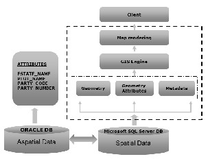
Fig: 1 A synoptic view of industrial Estate System
IJSER © 2012 http://www.ijser.org
International Journal of Scientific & Engineering Research, Volume 3, Issue 9, September -2012 2
ISSN 2229-5518

Spatial database creation is a vital step where interactive decisions are required like finding the associatively of Industrial Plots, buffer analysis and hence propose site suitability based on custom criteria. Spatial entities are digitized on satellite imagery of cartosat data having 2.5 meter resolution. Cadastral maps have also been co-registered with satellite imagery.
Fig: 2 W orkflow of the System
To construct spatial data, cartosat satellite imagery having resolution of 2.5 meters is used for creating base maps including industrial plots. Departmental data is linked with the spatial database to make a dynamic seamless information matrix. Spatial dataset like Location of Industrial estates, Layout of Industrial estates, Plot-wise details like Unsold notes; Taxation; Maintenance etc., Layout of Utilities like Industrial Zones, Water Supply System, Waste Water Treatment System Plant, Solid Waste Management, Drainage, Power Supply etc., Infrastructure facilities, Super imposing Revenue map, Amenities etc. are derived.
DSS is knowledge based system that serves the management, operations, and planning levels of an organization and helps to make decisions, which may be rapidly changing and not easily specified in advance [3].
Web Interface has authentication condition to allow specific users to access the portal. The portal has in built query builder to process user’s custom criteria. In this scenario, bridging between spatial and aspatial information has lead to an enterprise level solution by facilitating certain tools like Daily land data creation, MIS report generation (Monthly, Quarterly, Vacant Plot List, etc.), Auto notice generation,
Updation of regional office transactions to central database server, Receipt and pay order generation, On-demand auto- generation of Offer letter (Lease deed, Scrutiny report, etc.), Selective dispatch of generated reports (eMail and/or hard copy), Report Generation etc.
Satellite Imagery and geographical entities are created at
Bhaskaracharya Institute for Space Applications and Geo- Informatics (BISAG).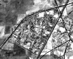
Fig: 3 Digitized layout map of Viramgam GIDC estate overlaid on satellite imagery
Web interface has facility to super impose multiple amenities, selecting interactive criteria based plots etc. on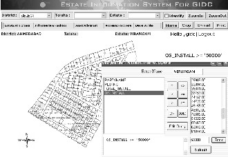
industrial plots as shown in below figure.
Fig 4: An example of Criteria for Outstanding amount >= 500000
By executing the criteria of Outstanding Amount >= ‘50000’, plot fields which satisfy the criteria will be highlighted with yellow color.
IJSER © 2012 http://www.ijser.org
International Journal of Scientific & Engineering Research, Volume 3, Issue 9, September -2012 3
ISSN 2229-5518
The authors would like to thank to the Director, BISAG, T .P. Singh and for his inspiration and motivation and Manager S&A, GIDC, Mr. H V Bagtharia for providing valuable technical support.
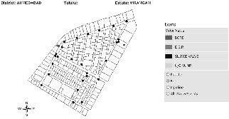
Fig 5: Super-imposing BORE and E.S.R. on Plot of Industrial Estates
By super-imposing BORE location and E.S.R. location, it is easy to find the source of water. Nearest source of water supply using buffer analysis can be derived easily.
The proposed methodology is capable to converge and extract datasets from the given data warehouse. Real time Decisions can be taken by implementing GIS engine which considers spatial dimension. The system provides aid to plan to regulate and control land use in the vicinity of the estate providing buffer zones around the estates. Decision makers can recommend land use controls around the estates for controlling and minimizing adverse environmental impacts, Recommending necessary effluent treatment and waste disposal facilities and other needed abatement infrastructures needed to be commonly used by all industries of the estate, Monitoring of the various planning, allotment details of the aspect etc.
Huge data in the form of spatial layers is process oriented. The proposed methodology can be optimized by introducing distributed computing. Parallel Processing of tasks can lead to improve the efficiency to produce spatial and aspatial output from complex user defined queries.
8 CONCLUSIONS
The proposed solution is scalable to enterprise level. Industrial Estates are crucial for financial growth of any nation. Geo spatial technology can not only be useful for better planning but also useful for better management of assets in industries. Convergence of MIS and GIS technologies can provide near real time information resulting in efficient and effective decision support system (DSS) to help multiple areas like Health, Defense, and Disaster etc.
[1] http://www1.ifc.org/wps/wcm/connect/72b3340048855c0c8ad4d a6a6515bb18/industrialestates_PPAH.pdf?MOD=AJPERES&CA CHEID=72b3340048855c0c8ad4da6a6515bb18.
[2] http://cg.gov.in/opportunities/Industrial%20Estates.pdf
[3] http://en.wikipedia.org/wiki/Decision_support_system
[4] Hettige M, Martin P, Singh M, Wheeler D (1995). The Industrial Pollution Projection System, Policy Research Department, Policy Research Working Paper 1431. World Bank.
[5] Smith VK, Andrès JE (1996). Environmental and Trade Policies: Some Methodological Lessons. Environ. Develop Econ., 1(1):
19-40.
[6] Townroe P.M. (1972) Some behavioural considerations in the industrial location decision Reional. Studies 6, 261-272
[7] Smith, D.M. (1976) Industrial Location: An Economic
Geographical Analysis. New York
[8] Visser, E.J. (2009), The complementary dynamic effects of clusters and networks for Industry Innovation
[9] Weber, A. (1999), Theory of the Location of Industries, Chicago, IL, University of Chicago Press.
[10] World Commission on Environment and Development 1987.
Our Common Future. Oxford: Oxford University Press.
[11] United Nations Environment Program 198 1. Guidelines for Assessing Industrial Impact and Environmental Criteria for the siting of Industry.
[12] Mohan. M.. Singh. M.P. and T.S. Panwar 1993. Industrial Growth and Management in Urban Areas. In. Heptulla. N. (ed.) Environmental Protection in Developing Countries. New Delhi: Oxford & IBH Publishing Co. PVT. Ltd. pp 29-34.
IJSER © 2012 http://www.ijser.org