International Journal of Scientific & Engineering Research, Volume 6, Issue 4, April-2015 73
ISSN 2229-5518
Creation, Maintenance and Comparison of Multipurpose Cadastre in Pakistan and Saudi Arabia
Khalid Mahmood, Sajid Rashid Ahmad
Abstract— Metropolitan regions often faced huge burden to handle to managing authorities for the linkage between transportation, land- use and environmental quality and from urban perspective about handling the other effects of growth such as loss of free land portion, housing availability, humidity and sprawl growth. The models (planning) which are using by Metropolitan authorities; are not designed in the way to overcome these needs. This multipurpose cadastral database including spatial, non-spatial data, and metadata; is designed to meet these needs and is being used in more than ten metropolitan regions for various environmental, planning, engineering, cadastral documentation projects. This work illustrates the each phase from field survey up to designing and maintaining multipurpose cadastral database.
Index Terms— Engineering, Environmental, Housing, Land-use, Planning, Metadata, Metropolitan, Multipurpose Cadastral Database, Non-spatial, Spatial, Sprawl Growth, Transportation, Urban Perspective
1 INTRODUCTION
—————————— ——————————

ISTORICALLY, the joint relationships among Pakistan and Saudi Arabia are close and very welcoming, sometimes termed as establishing a superior relationship.
Figure 1: World map location for Pakistan and Saudi Arabia
Pakistan supports its correlation with Saudi Arabia as their most "significant and mutual partnership" in the present overseas policy of Pakistan, functioning and looking for to grow closer joint ties with Saudi Arabia, the biggest country on the Arabian peninsula and honor to the two blessed cities of the religion Islam, which are Makkah and Madinah and the target of Muslim hajis from the globe.
Saudi Arabia states Pakistan to be its nearby non-Arab friend and closest Muslim friend country.
Agreeing to a Pew Research Center assessment, Pakistanis grip the maximum promising perception of the desert kingdom over the globe, with 95% observing Saudi Arabia positively and none having a negative opinion (Kohut and Bell 2013). By one of
————————————————
• Khalid Mahmood is currently pursuing master of philosophy degree pro- gram in Geomatics at Institute of Geology, University of the Punjab, La- hore, Pakistan, PH-00923336252495. E-mail: kmc786pak@gmail.com
• Sajid Rashid Ahmad a professor doctor is Director GIS Center and profes- sor at Institute of Geology, University of the Punjab, Lahore, Pakistan, PH-
00923129801510. E-mail: sajidpu@yahoo.com
the biggest armies over the globe and by way of the only affirmed nuclear power between the Muslim states, Pakistan has upheld a sole situation to support Saudi Arabia with its protection re- quirements. The kingdom has frequently strained to encourage Pakistan through gifts and mortgages, e.g. in 2014 it provided
Pakistan two hundred tons of dates as a gift (Ziauddin 2014).
The main focus here is to describe detailed creation and
maintenance structure of multipurpose cadastre in Pakistan and Kingdom of Saudi Arabia. All over the world, there were movements to establish fully digitized cadastre during the last
10 years. It is accepted that cadastral systems will be imple- mented more and more in future and will be planned to assist land market along with effective administration, development and management. After having multipurpose, will be very helpful for construction, engineering and other projects. We can also cov- er the issue of shortage of land waste disposal and inappropriate
landfill site in urban area (Ahmad and Mahmood 2012).
Right of entry and rights to use land in rural areas is a prob- lem of significant position. On the other hand, analogous to sev- eral other rising countries, the cadastre and land registration ar- rangements are one of the weak regions. Firming up these sys- tems is an elementary requirement and a way of motivating de- velopment procedure. Roughly the significant features of these systems contain; improved information base for planning and administration, well description of rights in land, additional po- tentials of finance development, stress-free execution of policy actions, and a superior directing and control. Diversity of aspects can be taken into concern as requirements, in order to implement a digital cadastral database (Ali et al. 2010). Land Information System (LIS) in Pakistan is established on customary system of land records and registers that are fairly complicated, out-of-date, and quite mismatched to new developments. In addition being quite ineffective, this system has many inconsistencies that have generated jams in the development procedure (Ali and Nasir
2010). After every 4 years, these records have been updated.
The traditional land information system in Pakistan is com- pletely based on charts, plots, maps and records on hardcopy
IJSER © 2015 http://www.ijser.org
International Journal of Scientific & Engineering Research, Volume 6, Issue 4, April-2015 74
ISSN 2229-5518
formats having no cartographic criteria with fairly outdated at- tributes (Gauhar 2004) and (Raza et al. 2005). Traditional maps of Pakistan are prepared deprived of any reference grid, and are generally rely on some landmarks such as streets, waterways, and mountains etc., where accessible. Also the physical circumstances of these traditional maps are not exactly good. Hence, digitizing such maps in their current existence would not be pretty reasona- ble (Ali and Nasir 2010). But, these traditional maps could aid as a good reference basis in generating new maps, no matter if based on any high resolution satellite images from IKONOS or Quick- Bird, record of ancient aerial photographs, or via ground surveys.
OBJECTIVES
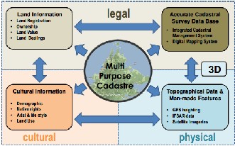
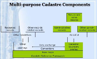
Cadastral systems surely assist a multipurpose use and thus fulfill the challenging tasks of an up-to-date GIS and IT atmos- phere (Enemark and Sevatdal 1999). Figure 2, multipurpose ca- dastre is described as cohesive land information system having legal, physical and cultural information in a mutual and precise reference framework. Legal information is about cadastre or property ownership. Land information including land registra- tion, ownership, land value and land dealings. Accurate cadastral survey database having integrated cadastral management system and digital mapping system. Physical information is about man- made features and topography. Topographical data & man-made features including GPS values along with satellite images. Cultur- al information is about demographics and land use. Cultural in- formation including demographic, native rights, life style and land use.
Figure 2: Multipurpose cadastre overview
A spatial information for single land lot must means that best up-to-date cadastral structures along with necessary part within cadastral database. For a country’s spatial data infrastructure, the cadastral map is becoming an important element. For an authori- ty’s land related activities, looking after the spatial records repre- sented within cadastral plan, is an obligatory workout for confir- mation of well-organized action. To examining cadastral map maintenance, here next summarizes inquiry difficulty, inquiry objective along with method. The thesis of this research is that all the stages from field survey to multipurpose cadastre develop- ment after focusing on quality control and technical specifications with an effective, efficient and timely manner.
The cadastral base map is most basically termed as a logically organized public catalogue of data regarding attributes under control, built according to surveyed boundaries (Henssen 1995).
As of a databank viewpoint, which is that inside LIS details exists as single, precise measurement usually mentioned in terms of lots. Lot summaries have usually presented via big scale charts, and have connected with word-based records along distribution of location units to needed associated objects.
Spatial depiction for separate lots causes the primary step for an authority lots map, termed as cadastre chart/map. Several up- to-date cadastral systems all over the globe, the separate spatial land lot explanation, the cadastral chart along with registration, privileges plus benefits, causes for the info databank of cadastre. All this spatial information is being stored in digital format grad- ually in today’s IT age. Approximately from 200 years, most areas of Europe are getting benefits of cadastre charts. On the other hand, vast regions of Australia are not getting benefits of cadastre charts because their currently existing system does not provide this facility (Williamson and Enemark 1996). Most regions of Aus- tralia had established electronic cadastre charts, recognized. This databank has revised many times after verification steps and im- provement checking. Update means all the incorporation changes in land lots due to development reasons and improvement means all amendments, modifications and corrections for database up- dation. Globally, cadastre charts’ maintenance have the same is- sues.
2 THE METHOD AND MATERIAL
Material
All the materials used for creating and maintain multipur- pose cadastre involves man power, GPS accessories by Trimble, Total Station accessories by Trimble, Computer Machines and Software (Trimble Business Center, AutoCAD Civil 3D, ArcGIS for Desktop, Microsoft World, Microsoft Excel, Microsoft Power Point, etc.).
Type of approaches
There are several type of approaches for methodology as il- lustrated below.
Process-based descriptions, rely on the logic that an infor- mation system be made up of numerous combined subsystems that assistance convert geographic data into valuable information were put into words formerly in the early 1970s by Tomlinson and others (Calkins and Tomlinson 1977). Soundly, the whole system must take account of processes for the input, storing, re- covery, analysis, and production of geographic information. Any practice of process-based definition of GIS put emphasis on the end-use of the information and, actually, must not suggest that computerization is take into account at all in the handling (Poi- ker, 1985).
Application approach, a minor alteration of the process- based approach produces a definition which classifies GIS per- mitting to the type of information being controlled. For instance, Pavlidis' cataloging scheme consist of natural resource portfolio systems, urban structures, planning and evaluation structures, administration command and control structures, and civilian sci- entific structures (Pavlidis 1982). A part of greatly improved care is the arena of land records, or multipurpose cadastre systems that practice the separate parcels as primary building blocks (McLaughlin 1984).
IJSER © 2015 http://www.ijser.org
International Journal of Scientific & Engineering Research, Volume 6, Issue 4, April-2015 75
ISSN 2229-5518
Toolbox approach of GIS originates from the clue that such a system integrates a cultured set of computer oriented processes and systems for managing spatial data. For example, published works by Tomlinson and Boyle (1981) and Dangermond (1983) deliver very broad descriptions of the working software roles that anyone could catch in a full organized GIS. Normally, these tools are structured rendering to the requirements of each process- based subsystem (e.g., input, inquiry, or output). The toolbox description suggests that all of these functions must exit and must work cool professionally to improve the transferal of a mul- tiplicity of diverse types of geographical data through the system and eventually into the approach of the end user. As a result, even although they are significant components of automatic ge- ography, neither digitization, satellite image processing, nor au- tomatic mapping systems succeed as GIS for the reason that they do not hold all the essential tools and do not deliver the complete incorporation of functions.
The database approach improves the toolbox meaning of GIS by emphasizing the simplicity of the communication of the other tools with the database. As Goodchild writes, "A GIS is well de- fined as a system which practices a spatial database to deliver responses to enquiries of a geographical nature, the universal GIS thus can be observed as a number of particular spatial procedures arranged over a standard interactive data base management sys- tem" (Goodchild 1985). Peuquet would approve that a GIS system must begin with a proper data model. Additionally, she describes that the victory of the GIS will be known by the proficiency that the data model offers for the recovery, enquiry, and presentation of the information (Peuquet 1984).
Methodology
Control surveys – field data acquisition
The selection of the field measurement systems are defined on the survey method selected in accordance with the intended use of the established control points. All survey systems used for the collection of control surveys observations are subject to the review and approval of the management.
Static/Fast Static Global Navigation Satellite System (GNSS) survey data collection has done in accordance with the approved network design and GNSS session plan to collect carrier-phase static GNSS observables at each occupied station. Dual frequency geodetic grade GNSS receivers equipped with standard accesso- ries have been used for the data collection process. The data has been electronically logged internally in the receiver memory or on a data logger. Static/fast static GNSS field observable data has collected using identical geodetic grade, dual frequency, and identical GNSS receivers with identical antennas. For higher accu- racy surveys, ground plane antennas may be specified to reduce the effects of multipath noise.
Data acquisition – traverse surveys
The acquisition of traverse field data has done according to the prepared traverse design where all traverse horizontal and vertical angles and slope distances has measured and recorded with sufficient redundancy to allow of the isolation of errors and poor precision measurements. All traverse surveys data collection process has done using the forced-centering technique whenever
possible. Each traverse station occupation observations has col- lected on the same day. If this is not possible for any reason such as end of work day at the middle of station observation collection or shortage of power supply, the whole survey occupation obser- vations could be repeated entirely on another day. All traverse horizontal angles has taken based on the right direction (angle right) which is controlled by the selection of back-sights/for- sights according to the traverse plan. Mixing left and right angles in one traverse have been avoided.
Prism offset constants has determined using standard profes-
sional practice and documented for each combination of total sta- tion instrument and prism. After the determination of prism con- stant errors, the total station and prisms has used as one set on all control surveys. No other combination is allowed without con- ducting proper tests to determine prism constant values. All dis- tance measurements has corrected for prism constant errors by entering the prism constants into the instrument prior to distance measurements. Care has taken to use the proper prism constant for each prism.
Although it is mandatory to log all traverse observations elec-
tronically, field crew has log all traverse data manually on ap- proved hard copy forms. All traverse observable data including horizontal angles, vertical angles, slope distances, atmospheric parameters, prism constants, instrument and target/reflector set- ups information, crew member information, weather conditions has clearly logged into field notes. Field notes has also include the assigned survey staff names and functions in addition to the type and serial number of equipment used during the survey. Traverse data has logged for every instrument setup/occupation in special form separately. The original field notes has properly scanned named and archived in an organized manner and submitted along with the survey report. Field notes has also include traverse diagram (sketch) showing relative locations of all stations used in the traverse. All stations on the traverse diagram has labeled with their ID's as shown on the monument and used in the field data file. Different symbol has used to distinguish newly established stations from existing project controls included in the traverse. The diagram has also show the consecutive instrument setup number as measured on the field and the direction of angle meas- urement.
Data acquisition – differential levelling
Differential leveling surveys has done using electrical numer- ical pin flattening systems through 1 part bar. Conditionally coor- dinated rod is in practice, those have been interchanged among setting. Therefore, these specifications applied to the use of the digital levels. Altogether difference-based flattening tools have accurately upheld along with frequently tested due to precision. Methodical miscalculations because of unwell upheld apparatus have removed to safeguard lawful survey modifications.
Data processing in CAD environment
Mostly in Pakistan, data is processed directly into GIS envi- ronment. In Saudi Arabia, topographic field survey data first comes to CAD department, they take GPS surveyed data and pro- cess it to create, check, maintain and update all the field recorded features.
IJSER © 2015 http://www.ijser.org
International Journal of Scientific & Engineering Research, Volume 6, Issue 4, April-2015 76
ISSN 2229-5518
CAD systems keep spatial data in the similar way as photo- graphic partings are used for the making of topographic draw- ings. Different kinds of geographic structures are located on sepa- rate layers that are then shared and printed with changed colors and line styles to produce the final item for consumption. Though the thought is similar, CAD systems deliver much more flexibility in terms of presentation tasks than do their photographic equiva- lents, and are mostly helpful for editing and bring up to date.
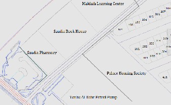
Figure 3: AutoCAD Civil 3D file overview
CAD systems have lots of limits when it thinks for analytical side, while providing key developments over photo mechanical approaches of map production. Actually, it is hard to tie attributes in a database to precise geographical objects and then by design allocate symbology on the source of user defined standards (Cowen et al. 1986). Such as, a CAD system can be utilized to gen- erate a graphical demonstration of a housing sub development containing of all the property outlines showing individual land lots. A CAD system is just a graphic system, this is not to an ad- vice that such structures are not valuable. In fact, a computer based CAD system related to World Data Bank II has delivered the City Department's Workplace of the Geographer with the ap- preciated ability to rapidly produce base maps for every part of the world (Heivly and White 1987).
Data processing in GIS environment
Though the start of GIS generally have been outlined to early work as digital mapping, there is a rich concept that the field is wider in scope nowadays than just automated map creation (Dueker 1979). Tomlinson specified that GIS is not a field only itself but quite the mutual ground between information handling and the numerous fields using spatial analysis methods (Tomlin- son 1972). Relying on explanation of GIS as "computer-based clas- sifications for the capture, storing, recovery, enquiry, and presen- tation of spatial data", it would give the impression that in the attentions of many GIS is just an easy item for nearly any type of automatic geographic data dealing out (Clark 1986).
In this task, the key objective is to collect, verify, and validate cadastral records and compile them into a multipurpose cadastral database. This database will be used as a basis for a multipurpose, parcel-based, Land Information System (LIS). The basic elements of cadastral data include geospatial layers such as city boundary, cadastral parcels, right of way corridors, easement corridors, ca- dastral tract boundary, and cadastral lot boundary. In addition,
the proposed LIS system include other supporting layers of geo- spatial data such as (but not limited to) roads, real estate property, buildings, facilities, and shoreline.
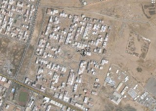
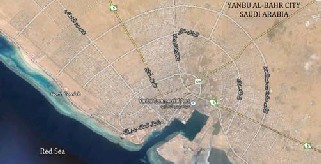
Figure 4: Imagery for Yanbu Al-Bahr city, Saudi Arabia
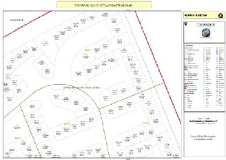
Figure 5: Imagery of Al-Waha Residence Society, Yanbu Al-Bahr, Saudi Arabia
Figure 6: Multipurpose Cadastre Layout, Al-Waha Residence So- ciety, Yanbu Al-Bahr, Saudi Arabia
IJSER © 2015 http://www.ijser.org
International Journal of Scientific & Engineering Research, Volume 6, Issue 4, April-2015 77
ISSN 2229-5518
Figure 7: Multipurpose Cadastre Components
3 CONCLUSION
On behalf of supervision staff on location-based cadastre rec- ords, organizations methodology for inspecting preservation of location-based cadastre chart being portion of whole location- based cadastre engineering have caused for quantity in fresh ide- as. A subsequent scheme explanations, mainly theoretical apprise exemplary, maximize abilities of numerical records along with permitting expertise. Success, competence & relevance for the discussing replicas has evaluated through frequent investigation communication via administrations answerable for cadastre charts in Saudi Arabia and Pakistan. Strategy idea signifies scheme exemplary which covers the said standards along with acceptability have tested with acceptance of thoughts.
In order to carefully document all its system proportions, this research has practiced an organized systems method to spatial and cadastral systems. The written document of location-based cadastre schemes along with improvement of numerical cadastre chart upkeep prototypes, seals slit with thoughtful of cadastre know-how schemes including delivers the base for upcoming exploration and investigation.
REFERENCES
[1] Ahmad, S.R. and Mahmood, K. (2012). GIS based landfill site selection for Faisalabad city. Journal of Himalayan Earth Sci- ence: Vol. 45, Issue 2, p7.
[2] Ali, Z. and Nasir, A. (2010). Land Administration System in
Pakistan - Current Situation and Stakeholders’ Perception, in XXIV FIG Congress 2010 "Facing the Challenges - Building the Capacity": Sydney, Australia.
[3] Ali, Z. and Nasir, A. (2010). Land administration: Reliability is the need of the hour, in GIS Development - The Global Ge- ospatial Magazine GIS Development Pvt. Ltd.: Noida, India. p. pp. 30-32.
[4] Ali, Z., Tuladhar, A. M. and Zevenbergen, J. A. (2010). Devel- oping a Framework for Improving the Quality of a Deterio- rated Land Administration System Based on an Exploratory Case Study in Pakistan. Nordic Journal of Surveying and Real Estate Research, 7(1): p. pp. 30-57.
[5] Calkins, H. W., and Tomlinson, R.F. (1977). Geographic In- formation Systems: Methods and Equipment for Land Use Planning. IGU Commission on Geographical Data Sensing and Processing and U.S. Geological Survey, Ottawa.
[6] Clarke, K. C. (1986). Advances in Geographic Information
Systems, Computers, Environment and Urban Systems, Vol.
10, pp. 175-184.
[7] Cowen, D. J., et al. (1986). Adding Topological Structureto PC-Based CAD Databases, Proceedings, Second International Symposium on Spatial Data Handling, pp. 132-141.
[8] Dangermond, J. (1983). A Classification of Software Compo- nents Commonly Used in Geographical Information Systems, Basic Readings in Geographic Information Systems (D. Mar- ble, H. Calkins, and D. Peuquet editors), SPAD Systems, Arnherst, N.Y.
[9] Dueker, K. J. (1979). Land Resource Information Systems: A Review of Fifteen Years’ Experience, Geo-Processing, Vol. 1, pp. 105-128.
[10] Enemark, S. and Sevatdal, H. (1999). Cadastres, Land Infor-
mation Systems and Planning- is decentralisation a signifi- cant key to sustainable development?, in UN-FIG Conference on Land Tenure and Cadastral Infrastructures for Sustainable Development: Melbourne, Australia.
[11] Gauhar, S. (2004), Mapping Pakistan - Taking a Leaf Out of
Sher Shah's Book, in Blue Chip: Islamabad.
[12] Goodchild, M. F. (1985). Geographic Information Systems in Undergraduate Geography: A Contemporary Dilemma, The Operational Geographer, Vol.8, pp. 34-38.
[13] Heivly, C. and White, T. (1987). Accessing Large Spatial Data
Bases Via a Microcomputer, Proceedings, Auto Carto VIII, pp. 623-629.
[14] Henssen, J. (1995). Basic principles of the main cadastral sys-
tems in the world. Proceedings of Commission 7, Seminar on Modern Cadastres and Cadastral Innovation. Delft, The Netherlands, May 1995.
[15] Kohut, A. and Bell, J. (2013). Saudi Arabia’s Image Fal- ters among Middle East Neighbors. Pew Research Center, 1-25.
[16] McLaughlin, J. D. (1984). The Multipurpose Cadastre Concept: Current Status, Future Prospects, Seminaron the Multi- purpose Cadastre: Moderning Land Information Systems in North America, University of Wisconsin Institute of Environmen- tal Studies, Madison.
[17] Pavlidis, M.G. (1982). Database Management for Geo- graphic Information Systems, Proceedings, National Conference on Energy Resource Management, Vol.1, pp. 255-260.
[18] Peuquet, D. I. (1984). A Conceptual Framework and
Comparison of Spatial Data Models, Cartographica, Vol.2, pp. 66-
113.
[19] Poiker, T. K., 1985. Geographic Information Systems in
the Geographic Curriculum, The Operational Geographer, Vol.8, pp. 38-41.
[20] Raza, F., Almas, M., and Ahmed, K. (2005), Land Records
Information Management System, in 25th Annual ESRI Interna- tional User Conference: San Diego, California.
[21] Tomlinson, R. F. (1972). Geographical Data Handling. IGU Commission on Geographical Data Sensing and Processing, Ottawa.
[22] Tomlinson, R. F. and Boyle, A. R. (1981). The State of Development of Systems for Handling National Resources Inven- tory Data, Cartographica, Vol. 18, pp. 65-95.
[23] Ziauddin, M. (2014). Grand gesture: Saudi Arabia gifts
200 tons of dates to Pakistan. The Express Tribune News Net-
work.
IJSER © 2015 http://www.ijser.org
International Journal of Scientific & Engineering Research, Volume 6, Issue 4, April-2015 78
ISSN 2229-5518
Khalid Mahmood s/o Samiullah was born on Oct 20, 1984 in the beautiful village Khanpur, Tehsil Mailsi, District Vehari, Punjab Pakistan. He got his matriculation from Government High School Mailsi (2000) Punjab, Pakistan, intermediate (2003) and bachelor’s degree (2005) from Government College Bosan Road Multan, Punjab, Pakistan and master’s degree (2008) from space science department with University of the Punjab, Lahore, Pakistan. After master’s degree started (2008) job in Geographical Information System (GIS) domain in Pakistan and then in 2012 got enrolled for the degree of Master of Philosophy in Geomatics with Institute of Geology, University of the Punjab, Lahore, Pakistan.
The employers named from start are National Engineering Ser- vices Pakistan (NESPAK) as GIS ASSISTANT, Soil Survey of Paki- stan as GIS ASSISTANT, Trafco Tracking Pakistan as GIS COOR- DINATOR and then joined Saudi Comet Co. Ltd. Saudi Arabia as GIS SUPERVISOR.
Sajid Rashid Ahmad is a Professor Doctor. He earned M.Sc. (2004-
2006) and PhD (2006-2010) degrees in Earth Sciences from Univer-
sity of Windsor, Ontario, Canada along with multiple scholar- ships/awards, training courses, workshops participation and published articles in referred journals and conferences. Early he has earned Master of Science degree in Applied Geology from Punjab University, Lahore Paksitan. Currently he is working as Professor Doctor at Institute of Geology and Director GIS Center, Punjab University, Lahore, Paksitan. He was president graduate student society at university of Windsor, Canada. He was assis- tant professor during Nov 1995 to May 2010 at Institute of Geolo- gy, Punjab University, Lahore Paksitan.
IJSER © 2015 http://www.ijser.org