International Journal of Scientific & Engineering Research, Volume 3, Issue 11, November-2012 1
ISSN 2229-5518
Analysis of revitalization of Badkhal Lake using innovative GIS technique
Ruby Siddiqui, Prof Gauhar Mahmood, Dr Syed Rehan Ali
Abstract-The Delhi Ridge is considered to be a water divide between arid climate of Rajasthan and semi- arid to sub-tropical climate of Indo-Gangetic Plains. Also the Delhi Ridge is the main carrier of
surface runoff .But due to urbanization, the Delhi Ridge has lost its peripheral runoff, and as a result
the water bodies fed by Delhi Ridge are suffering and are losing their identity.
There is an utmost need for the revitalization of these water bodies which is important not only from
the microclimatic point of view but also is an essential tool for the replenishment of the ground water resources .The ground water resources with the pace of deterioration of water bodies on one hand and excessive abstraction on the other hand, are getting depleted fastly and has acquired a continuous declining trend. The minimum declining of the water table is in the range of 2.5-3.5 m per year and the maximum of 6.5-7 m per year which clearly indicates need for revitalization of water bodies.
There are number of water bodies in NCR which has saturated within the premises of Delhi Ridge runoff. The present study deals with the Badkhal Lake which was originally occupied by 18.7 km2 has been shrunk to 5.1 km2 which is 27.2 % of its original volume .This is because of unplanned urbanization impact. The present study deals with the analysis of revitalization of Badkhal Lake using innovative technique such as Geographical Information System (GIS) for design of watershed and catchment to acquire the the requisite amount of runoff for the proper replenishment of Badkhal lake .This study will be the modal example of revitalization of the water bodies in order to improve the geo environment in general and water resources in particular. Apart from this there are many other ideas which may be used for planners, architects, scientists, administrative officers working in this direction.
Key words: Revitalization, watershed, Badkhal
Lake, GIS, runoff
Research Scholar, Geology Department, CMJ University,Shillong,email- siddiquiruby99@yahoo.co.in
Professor (Geology Section) Civil Engg. Department, Faculty of Engg. & technology, Jamia Millia Islamia,New Delhi
Associate Professor & Head, Department of Civil Engg., Teerthankar Mahaveer University,Moradabad
1. Introduction
1.1 General
The Delhi Ridge which is the part of Aravalli super group has got the significant importance in geological phenomenon in general and in hydrological spectrum in particular. The Delhi Ridge starts from Jaipur area in the form of eskers and is responsible for the local aggradations of land area which in turn known as water right from desert area of Rajasthan and that of NCR in Delhi onwards.
The Aravalli Ridge is the main constituents of Aravalli super group which is responsible to carry all local runoff from the upland area of Jaipur to the NCR in and around Delhi. In fact the entire
Indus basin particularly in Rajasthan area is controlled by Aravalli Ridge.
The Delhi Ridge is the main Hydroboundry and which divides Yamuna basin and Indus basin. The southern part of Delhi Ridge forms many water bodies at the southern part of Delhi and NCR.
The pace of urbanization has disturbed the Delhi ridge in general and the catchment in particular by virtue of which the water bodies of historical importance started vanishing. The matter became more worse with the advent of new drilling technology such as Down Throw Hammer which drills the tube wells quite deep in the hard rock area .With the development and growth of population in and around Delhi ridge and in historical water bodies the rate of abstraction of groundwater gradually increased by virtue of which the grated gravel in and around historical water bodies started declining. As a result water table goes very deep and seepage losses from these water bodies gradually increased with the pace of declining water level. In this way, the decline of water level of water bodies and seepage losses both are responsible for deterioration of water level of Badkhal Lake which has shrunken about 25-30% of its original volume.
IJSER © 2012 http://www.ijser.org
International Journal of Scientific & Engineering Research, Volume 3, Issue 11, November-2012 2
ISSN 2229-5518
1.2 Badkhal Lake
The Badkhal Lake is located 30 km from Delhi and lies in Faridabad District located in 28⁰25’ N latitude and 77⁰ 18’ E longitude and it is the most important tourist place maintained by Haryana tourism. Since the area in Badkhal area is surrounded by Tilput range of hard Quartzite terrain and therefore any water body of this magnitude will provide the thermal comfort and good ambience for the tourists. The Badkhal lake area is originally occupied by 18.7 lakh meter square as evident from SOI Toposheet number
53H/7& 53H/3.However due to the disturbance its watershed and the catchment the lake has shrunk down to 5.1 lakh meter square which is actually
27.2% of its original dimension. Currently the lake
carries very nominal amount of water and dries in the peak summer season of May and June. Considering the historical factor and the tourism, revitalization of Badkhal Lake is very essential and it may be treated as National Development Activity. Since the state of art at present is governed by the modern technique such as application of GIS, Geophysics, Hydrology and Hydrogeology in order to calculate the catchment delineation, mapping of watershed and losses of the lake water therefore it is imperative to apply the latest knowledge for the subject matter.
2. Objectives and scope of the study:
2.1 The following objectives shall be achieved for the revitalization of water bodies in general and for Badkhal Lake:
1. To delineate the catchment area of Badkhal lake in present condition.
2. To delineate the drainage system and the modern watershed of this lake
3. To calculate the surface runoff with varying rainfall intensity.
4. Finally to provide the sustainability of the Badkhal lake with the help of delineation of systematic hydrological and hydro geological system.
2.2 Scope of the study:
Badkhal Lake is one of the prominent water bodies in Faridabad and is deteriorating because of the disturbed catchment and watershed due to mining
and urbanization. Hence the present study shall be
able to solve the above mentioned problem by innovative techniques using modern equipments and tools for the sustainable development of water bodies of Badkhal Lake.
3 . Methodology adopted
The following methodologies were adopted in order to achieve the result for the revitalization of Badkhal Lake:
1. Delineation of watershed of Badkhal lake area -The watershed of Badkhal lake was analysed on the basis of Survey of India Toposheet no 53H/7 and
53H/3 in which all the major drainage system
connecting to the Badkhal lake were analysed on regional basis at a scale of 1:50,000 and then the watershed of the major drainage system were further delineated.
2. Once the watershed were analysed the runoff
calculation were carried out on the basis of rainfall pattern of the area.
3. The rainfall patterns were analyzed on the basis of Precipitation data available at Meteorological Department sources at different stations. In this way the data from year 1910 to 2010 was analysed.
4. The climatic data was analyses on the regional basis from Meteorological Department sources as temperature, humidity and evaporation and likewise so that the losses from water bodies such as evaporation, evapotranspiration, seepage could be calculated.
5. The prevention of runoff due to Bhatti mines were also calculated on the basis of self investigation.
In this way the hydrologic equation I~O±Δ S was considered for the revitalization and sustainability of Badkhal Lake.
The above equation indicates that “I” is the inflow factor which is incoming into Badkhal lake from surrounding area and “O” is the out flow factor which is outgoing water and losses from the Badkhal lake area and thus the storage “±Δ S” has been considered.
4 .Description of the study area
The Badkhal Lake is located at latitude 28024’E longitude 77016’N.Sited at Faridabad district of Haryana State and at a distance of 32 kms from
IJSER © 2012 http://www.ijser.org
International Journal of Scientific & Engineering Research, Volume 3, Issue 11, November-2012 3
ISSN 2229-5518
South Delhi, Badkhal Lake is placed in the eastern
side of vicinity of southern part of Delhi Ridge of Aravalli Super group. Badkhal Lake is a rainwater nourished lake formed between two hillocks. Badkhal lake which is a low lying area gets rainfall runoff from northern, western and south western side by Delhi ridge .An embankment is build on it to control it water flow to east and south east side area which is densely urbanised and includes localities like Maharajpur,Aitmadpur,Faridabad New Town and Ballabgarh.
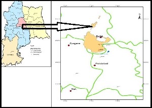
Figure1:The Location Map of Badkhal Lake,Faridabad
District,Delhi NCR
The wet area of Badkhal Lake is only 5.1 lakh meters square left which is actually 27.2% of its original 18.7 lakh meter square area. It acts as a barrier for excessive flood water flow and also prevents soil erosion in the area. But its catchment has disturbed due to mining activity and urbanization factor by interrupting the continuity of the runoff flow and leading huge debris flow towards the lake.
5. Microclimatology of Badkhal Lake
Faridabad’s climate is regarded as arid to semi-arid and wide temperature variation is noted with very uneven rainfall pattern. The Microclimatic Analysis clearly indicates that the response of the rainfall much higher in the months of rainy days but the temperature is also very high in that period by the increase of temperature the humidity increases and rate of Evaporation and Evapotranspiration increases which is one of the major reason for the loss of water in the Badkhal lake area.
5.1 Temperature
Temperature data for last six years from 2006 to
2011 was collected from Indian Meteorological Department and an average rainfall of these six years was considered for calculation of water losses due to high temperature ,which depicted that Pre-monsoon months are the hottest months recorded with a maximum temperature of 41.5 C in the months of June, July and August which is generally followed by rain and thus lowering the peak temperatures which otherwise causes heavy water losses due to evaporation and evapotranspiration.
5.2 Humidity
Humidity data for last six years from 2006 to 2011 was collected from Indian Meteorological Department. Humidity is highest during the rainy months. Highest humidity of 81%has been recorded in the month of August and a minimum of 24% in the month of May has been recorded. Thus May is the driest month when humidity is least.
Months | Temperature Mean daily in degree centigrade | Relative Humidity in % |
Months | Max. Min. | Max. Min. |
January | 19.4 | 4.7 | 74 | 45 |
February | 22.5 | 7.2 | 68 | 43 |
March | 29.6 | 11.4 | 62 | 37 |
April | 37.3 | 19.4 | 44 | 27 |
May | 40.3 | 24.7 | 45 | 24 |
June | 41.5 | 27.7 | 55 | 37 |
July | 35.5 | 26.4 | 78 | 64 |
August | 34.3 | 24.1 | 81 | 73 |
September | 35.3 | 21.8 | 71 | 57 |
October | 34.8 | 16.6 | 60 | 41 |
November | 28 | 11.7 | 63 | 41 |
December | 23.7 | 5.1 | 70 | 45 |
Table 1: Temperature, Relative Humidity in Faridabad
District (2006-2011) SOURCE: IMD
5.3 Rainfall
The southwest monsoon cases heavy rain to fall in the region in rainy months starting from Last week
IJSER © 2012 http://www.ijser.org
International Journal of Scientific & Engineering Research, Volume 3, Issue 11, November-2012 4
ISSN 2229-5518
of June to End of September. Frequency of rain is
highest in the months of July and August reaching
up to 338.8 mm in the month of August in 2010
causing flooding in many low lying areas.
Month | Jan | Feb | Mar | Apr | May | Jun | July | Aug | Sep | Oct | Nov | Dec | Total |
2006 | 3.2 | 0 | 17.8 | 2.8 | 93.2 | 90.2 | 263.6 | 66.3 | 78.5 | 0.4 | 0.3 | 2.4 | 618.7 |
2007 | 0 | 49.8 | 54.4 | 0 | 40.4 | 83.8 | 83.6 | 216.8 | 72.8 | 0 | 0 | 0 | 601.6 |
2008 | 1.8 | 0 | 0 | 31 | 136.6 | 100.7 | 166.2 | 299.1 | 115.6 | 0 | 0 | 0 | 815 |
2009 | 402 | 6.5 | 3.9 | 2 | 43 | 5.4 | 124.2 | 188.6 | 201.9 | 0.3 | 14.2 | 1.05 | 595.5 |
2010 | 0 | 14.2 | 0 | 1.2 | 7.6 | 4.6 | 236.8 | 338.8 | 314.2 | 22 | 13.4 | 0.3 | 953.1 |
2011 | 0 | 49.9 | 2.3 | 2.2 | 33.4 | 104.4 | 33.8 | 272.4 | 163.4 | - | - | - | 489.2@ |
Table 2: Monthly, Annual and Mean Rainfall (mm) data of Faridabad District
SOURCE: Agromet.observatory, division of agricultural physics,IARI,New Delhi
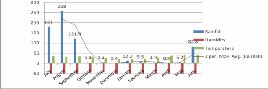
Graph 1: Graph showing Average of Rainfall, humidity,
Temperature variation for six years (2006-2011) of Faridabad
District
The study of rainfall data of last 6 years as depicted from graph 1 shows that there is a sharp decline in the temperature factor after rainfall .Only 80% of the runoff generated by the Aravalli Ridge reaches the study area lake while rest is lost due to many natural processes like evaporation, evapotranspiration, seepage, and man-made activities like construction and mining activity.
6. Analysis and discussion
1. Delineation and analysis of watershed of Badkhal lake area.
2. Hydro meteorological analysis of Badkhal lake area including climatic conditions
3. Analysis of seepage rate of Badkhal lake area.
4. Analysis of surface geology of Badkhal lake area.
5. Hydro geological analysis for the groundwater conditions and behaviour of Badkhal lake .
6. Sustainability analysis of Badkhal lake area to verify the hydrologic equation for storage capacity and enhancement for revitalization of Badkhal lake area.
7 .Geological interpretation of Badkhal lake area
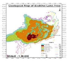
The geological mapping for the watershed area of the Badkhal Lake was carried with the help of survey of India toposheet no. H43X3 and H43X7
on a scale of 1:50 000 as well as reconoiscence
survey which was carried out in the field followed by detailed geological survey in which the rock sampling was done at an interval of every 100 m or change of lithology on a grid pattern .
In this way, all the lithologies were covered for entire watershed area of Badkhal lake in order to analyse the response of runoff on various lithological units present in the area .The following lithologies have been encountered in the water shed area and its topographical relief was also measured to acquire the complete physiography of the watershed area.
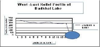
Figure 2 :West-East relief profile of Badkhal lake
A relief profile as evident from figure 3 was drawn from west to east direction starting from the Aravalli ridge area towards Badkhal lake area along with their relief and their respective area occupied in square kilometres .These
IJSER © 2012 http://www.ijser.org
International Journal of Scientific & Engineering Research, Volume 3, Issue 11, November-2012 5
ISSN 2229-5518
physiographic units were particularly analyzed
with reference to different lithological units. The maximum mean sea level recorded were 315.3 m in Aravalli Ridge area and a minimum of 220 m at Badkhal lake reservoir .In this way, it is evident that a steep gradient is established which is about
105 m in 13 km land which indicates the average gradient which is about 7.6m/km . The average gradient shows that the area has got hilly topography, by virtue of which the existence of lake was possible.
Figure 3: Geological Map of Badkhal Lake
S.No. | Label | Lithology | Area(km2) | Relief(in meters) |
1 | A | Hard quartzite | 6.64 | 315-300 |
2 | B | Fractured quartzite | 60.41 | 300-280 |
3 | C | Weathered quartzite | 30.9 | 280-270 |
4 | D | Silty Sand | 23.22 | 270-250 |
5 | E | Sandy Silt | 11.2 | 250-240 |
6 | F | Silt | 7.51 | 240-220 |
Table3: The lithological units of watershed area of Badkhal
Lake
Further details of each lithological unit are demarcated in table 3 which indicates that the hard quartzite occupies 6.64 km2 areas. With a relief starting from 315m to 300m with a very steep gradient .Further, the hard quartzite is followed by fractured quartzite which occupies a major portion of the area which is about 60.41 km2 with a relief of 300-280 m with a moderately steep gradient .However, in this portion of watershed area lots of local open cast mining as sand quarries are present by virtue of which the runoff have been
effected greatly and may be analyzed as one of the
major reason for the deterioration of Badkhal lake. This aspect of watershed seems to be irreparable
.However, the local ditches recharge the ground
water and ultimately the groundwater gets diverted to Yamuna river .The next lithological unit of the watershed in its hierarchy found as weathered quartzite which occupies the second largest lithological unit of the area of 30.9 km2 with comparatively a moderate slope with a relief of
280-270m which indicates that in the weathered quartzite regime being occupied by flat topography which forms a plateau and may be become major cause of runoff prevention from hillside to Badkhal lake. This physiographic unit requires lots of ground improvement in order to increase the runoff.
The situation becomes further worsen because of the local ditches created by mines. The silty sand which is another litho unit occupies an area of 23.2 km2 with a step gradient from 270-250 m.This litho unit being occupied by sand is not of much help to runoff improvement due to its own litho character which occurs naturally and may be treated as the moderate type of watershed even after having steep gradient.
The sandy silt is the second last litho unit and occupies 11.20 km2 of area with very steep gradient and is helpful to get good runoff. However, the other lithological unit encountered in the stream direction diminishes the runoff by virtue of which this litho unit may not be treated as good runoff area. The last litho unit is silt after which the Badkhal Lake starts. Although, this unit has got a good relief but the water holding capacity due to high porosity does not allow a good amount of runoff to go to Badkhal Lake.
In all it is evident from the entire litho spectrum of the watershed of Badkhal Lake area that the litho units in its natural sense are of a great help for the runoff .However, due to man-made disturbances and urbanization, the runoff of the catchment has been disturbed and needs engineering solution for their revitalization.
8 . Analysis of watershed and drainage system of
Badkhal lake
The watershed analysis was carried out for entire watershed of the Badkhal lake area for the
IJSER © 2012 http://www.ijser.org
International Journal of Scientific & Engineering Research, Volume 3, Issue 11, November-2012 6
ISSN 2229-5518
calculation of response of the rainfall on various
lithological units and drainage system has been shown on the figure 5.The perusal of the map indicates the major drainage system comes from W-E direction in which it is found that the drainage follows the relief pattern in general. However, the regular dendritic drainage pattern gets disturbed due to local stone quarries and mining along with the roads and settlements .It is seen that the watershed is mostly disturbed due to urbanization factor by virtue of which the adequate amount of runoff does not reach to the Badkhal lake .
| quartzite | | | | |
4 | Silty Sand | 0.2 | 611 | 23.2 2 | 2.837 |
5 | Sandy Silt | 0.2 | 611 | 11.2 | 1.386 |
6 | Silt | 0.12 | 611 | 7.51 | 0.55 |
| | | | | Total= 27.74 (mcm) |
Table 4: Analysis of Run-off potential of watershed area of
Badkhal Lake
Q=Total available runoff C=Runoff Coefficient I=Intensity of Rainfall A=Area in km2
The analysis of runoff potential of watershed area indicates that there are number of local drainage generated from Aravalli area to Badkhal Lake
.However, the density of discharge seems to be very low as compared to watershed area of Badkhal Lake which is the main concern of the present watershed and drainage system. The empirical relation has been established by applying the formula
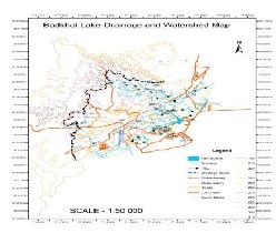
Figure 4: Drainage and Watershed map of Badkhal Lake

The local stone quarries and mining activity in the close vicinity of the lake has also increase the sediment flow to the Badkhal lake . Thus the volume of the lake has also reduced due to excessive sedimentation .The analysis of the runoff generated in the watershed area of Badkhal Lake as per lithology variance and gradient are as follows-
Q=CIA
Where Q is the total runoff and C is taken as coefficient of runoff and I is taken as intensity of rainfall ,A=Area in .It is found that there are six lithological units which are already described with their occupied area in km2 in Table 4.The runoff generated from the individual litho-units were calculated with the assumption that the watershed is undisturbed .It was analysed that the runoff generated from
Hard quartzite =2.8mcm (million cubic meter ) Fractured quartzite was= 14.7mcm Weathered quartzite =5.6mcm
Silty sand=2.8mcm Sandy silt=1.3mcm Silt=0.54mcm was generated.
In totality, the runoff was generated as 27.74 mcm. However, it is found that the area is highly disturbed by the mining activity and also by the construction of urbanization projects such as roads, bunding and houses which has disturbed the runoff and only 10-15 % of the runoff remains for the replenishment of Badkhal Lake which may be taken as 2.7-3mcm as a final total runoff to reach
IJSER © 2012 http://www.ijser.org
International Journal of Scientific & Engineering Research, Volume 3, Issue 11, November-2012 7
ISSN 2229-5518
badkhal Lake. In this way, it may be analysed that
the runoff for the watershed area are good enough for the Badkhal Lake with the help of training of drainage system using the innovative technique such as continuous connectivity of the small reservoir of mining and provision of aqueducts or subsurface waterways from the tangent of the watershed in order to replenish the Badkhal Lake.
Further, it is also analysed that the drainage system
in the downstream direction are weathered quartzite and alluvial zone needs the repairing and broadening of drainage system with the help of connectivity of RCC drain to Badkhal Lake area
.The rainwater harvesting master plan from the settlement to Badkhal Lake will further improve the replenishment condition of Badkhal Lake .
S.No | Months | Average runoff coefficient | Average intensity of rainfall For last six years(mm) | Area of watershed for all lithologies Of the watershed area(m2) | Average monthly runoff potential in m2 |
1 | January | 0.32 | 1.53 | 62311473 | 32244577 |
2 | February | 0.32 | 20.06 | 62311473 | 422762229 |
3 | March | 0.32 | 13.06 | 62311473 | 275238022 |
4 | April | 0.32 | 6.5 | 62311473 | 13698664 |
5 | May | 0.32 | 59.03 | 62311473 | 1.244E+09 |
6 | June | 0.32 | 64.81 | 62311473 | 1.366E+09 |
7 | July | 0.32 | 151.36 | 62311473 | 3.19E+09 |
8 | August | 0.32 | 185.3 | 62311473 | 3.905E+09 |
9 | September | 0.32 | 157.76 | 62311473 | 3.325E+09 |
10 | October | 0.32 | 3.9 | 62311473 | 82192059 |
11 | November | 0.32 | 3.9 | 62311473 | 97998224 |
12 | December | 0.32 | 0.616 | 62311473 | 12982130 |
Table 5 Average monthly runoff potential available to Badkhal Lake from its water shed.
IJSER © 2012 http://www.ijser.org
International Journal of Scientific & Engineering Research, Volume 3, Issue 11, November-2012 8
ISSN 2229-5518
9.Seasonal response of Badkhal lake with its
expansion and shrinkage
Seasonal response of Badkhal Lake’s original extent occupies a vast area of 21.2 Lac m2 in which the remaining wet area has been analysed as 3.4
Lac m2 which clearly indicates that about 16% of the area remains as wet area .This is because of the mining and urbanization factors such as roads and settlements around Badkhal Lake area.
For the simplicity of calculation study of seasonal response with the expansion and shrinkage of Badkhal Lake has been carried out which is shown in the table no-6
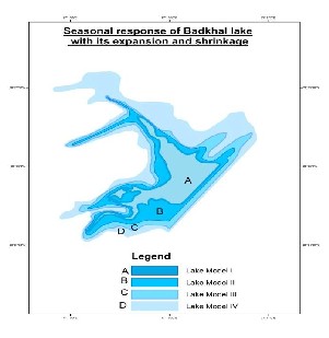
Figure 5: Seasonal response of Badkhal Lake with its expansion and shrinkage
It is found that Badkhal Lake may be divided into
four zones namely A,B,C,D with the projection of models I,II,III,IV .It is found that since zone A has got the highest depth of 8.6 m on an average which occupies the volume of the water as 2.72 mcm which is a conformity to our previous calculation that only this amount of water through runoff is reaching to the lake and so the present condition of the lake represented by the shed volume
.However, in order develop the B zone of the lake which occupies an area of 6.75 Lac m2 with an average depth of 6.2m will require about 4.1 mcm of water. likely to develop model III which occupies an area of 9.58 Lac m2 with an average depth of 5.3 m will require the volume of runoff as
5.07 mcm and lastly in order to develop the D zone of the lake which occupies an area of 1.5 Lac m2 in an average depth of 4.1m will require 0.64 mcm of runoff .

Table 6: Seasonal response of Badkhal lake with its growth and shrinkage
IJSER © 2012 http://www.ijser.org
International Journal of Scientific & Engineering Research, Volume 3, Issue 11, November-2012 9
ISSN 2229-5518
In all it seems that the total runoff generated by the
watershed is about 27.74 mcm and the total requirement of all zones is about 12.53 mcm .It is clear from the runoff calculation and water requirement calculation that more than double amount of water has been generated by the watershed of Badkhal Lake .Also, taking 50% due to seepage ,evaporation and evapotranspiration even then the requisite amount of rainfall runoff is available to the watershed of the Badkhal Lake area which proves that the revitalization of Badkhal Lake is possible with careful engineering design .
10. Conclusion
The pace of urbanization has disturbed the Delhi ridge in general and the catchment in particular by virtue of which the water bodies of historical importance started vanishing. The matter became more worse with the advent of new drilling technology such as Down Throw Hammer which drills the tube wells quite deep in the hard rock area .With the development and growth of population in and around Delhi ridge and in historical water bodies the rate of abstraction of groundwater gradually increased by virtue of which the grated gravel in and around historical water bodies started declining. As a result water table goes very deep and seepage losses from these water bodies gradually increased with the pace of declining water level. In this way the water shed declining of water bodies and seepage losses both are responsible for deterioration of water level of historical importance such as Badkhal Lake which has shrunken about 25-30% of its original Shape
The Badkhal Lake is located in Faridabad District and it is the most important tourist place maintained by Haryana tourism. Since the area in Badkhal area is surrounded by Tilput range of hard Quartzite terrain and therefore any water body of this magnitude will provide the thermal comfort and good ambience for the tourists. The Badkhal lake area is originally occupied by 18.7 lakh meter square Badkhal Lake is one of the prominent water bodies in Faridabad and is deteriorating because of the disturbed catchment and watershed due to mining and urbanization. Hence the present study shall be able to solve the above mentioned problem by innovative techniques using modern equipments and tools for
the sustainable development of water bodies of
Badkhal Lake.
The watershed analysis was carried out for entire watershed of the Badkhal lake area for the calculation of response of the rainfall on various lithological units and drainage system
It is seen that the watershed is mostly disturbed due to urbanization factor by virtue of which the adequate amount of runoff does not reach to the Badkhal lake .The local stone quarries and mining activity in the close vicinity of the lake has also increase the sediment flow to the Badkhal Lake. Thus the volume of the lake has also reduced due to excessive sedimentation In all it seems that the total runoff generated by the watershed is about
27.74 mcm and the total requirement of all zones is about 12.53 mcm .It is clear from the runoff calculation and water requirement calculation that more than double amount of water has been generated by the watershed of Badkhal Lake .Also, taking 50% due to seepage ,evaporation and evapotranspiration even then the requisite amount of rainfall runoff is available to the watershed of the Badkhal Lake area which proves that the revitalization of Badkhal Lake is possible with careful engineering design .
11.Suggestions
The Following suggestions have been made with reference to revitalization of Badkhal Lake.
i. The complete Watershed of the Badkhal Lake must be obtained using old records of maps and literature.
ii.The impact on original watershed due to
Urbanization must be redefine and redesign.
iii.The drainage system of Latest watershed with mixed drainage combindly such as manmade storm water drain due to urbanization and natural drainage such as nallah and gullies must be combined together to get proper amount of run off to Badkhal lake.
iv. The Rainwater Harvesting Master Plan with the pace of development of the surrounding area at least for 50 years future growth must be taken for Feasibility and Design of Rainwater Harvesting master Plan.
IJSER © 2012 http://www.ijser.org
International Journal of Scientific & Engineering Research, Volume 3, Issue 11, November-2012 10
ISSN 2229-5518
v. The Four Zones of the Badkhal Lake must be replenished as per the latest watershed using Rin Water harvesting Master Plan.
v. The Desilting and Evaporation and Evapotranspiration losses must controlled using Check dams, Cascades and Non Evaporative and harmless chemicals.
vii. The Surplus amount of water from the water logged areas available in the drains due to monsoon run off must be considered.
References
1-Geiger, W. F. et al (1987) Manual on Drainage in Urbanised Areas. Vol. 1., Planning and Design of Drainage System, UNESCO.
2-Horton, R. E., 1932, Drainage Basin Characteristics
3-Mittal S.P., Sharma J. S., (1998), watershed Mangemnt Experinces of Siwalik Foot Hill Region of North India (Proceedings of Int. watershed managemnt 8-10 Dec. 19980, CBIP, New delhi (287-295).
4-Kamalam Joseph, Jose K. I. (1998), A Study of the Watershed Development Programme – Lessons Learned and Suggestions for Future, (Proceedings of Int. Conf. Watershed Managemnt 8-10 Dec. 1998), CBIP, New Delhi (234-241).
5-Chow, V. T.(1964) Handbook of Applied Hydrology, Mc
Graw – Hills Co., New York, 4, 39-76.
6-Abrahim Philip (1998) Watershed Management – Objectives and Strategies (Proceedings of Int. Conf. Watershed Management), CBIP, New Delhi (91-98).
7-Bouwer, H., Groundwater Hydrology, McGraw –Hill, New
York, 480 pp., 1978.
8-Baweja, B. K. and Karanth, K. R. (1980) Groundwater Recharge Estimation in India, tech. Sr. H., Bull. 2, Central Groundwaer Board.
9-Field Manual on Watershed Management by Central
Research Institute for Dryland Agriculture, Hyderabad (1998).
10-Chopra, S. (1990) A Geological Cum Geomorphological Framework of Haryana and Adjoining Areas for Landuse Appraisal Using LANDSAT IMAGERY. Photonirvachak, Jour. Ind. Soc. Of Remote Sensing, Vol. 18 No. 12. pp. 15-22.
11-Christensen S., Rasmussen K. R., Moller K., (1998), Prediction of Groundwater Flow to Streams, Groundwater, vol. 36, No. 2 Mar-April 1998 (351-360).
12-Babu Rao P., Sreenivas Prasad P., Iftekhar Ahmad S. (1998) Watershed Management and Consequential Conservation / Augmentation to Groundwater Resources (Proceedings of Int. Conf. Watershed management 8 –10 Dec.
1998), CBIP, New Delhi (259-268).
13-Groundwater Information Booklet, Faridabad, District Haryana, 2007, Central Groundwater Board, Ministry of Water Resources, Govt. of India.
14-Agiculture Contingency Plan District:Faridabad,Department of Agriculture Meterology,Faridabad
IJSER © 2012 http://www.ijser.org
International Journal of Scientific & Engineering Research, Volume3, Issue 11, November-2012 11
ISSN 2229-5518
IJSER ©2012
http://WWW.I!Ser. org
International Journa I of Scientific & Engineering Research Volume 3, Issue 11,November 2012
ISSN 2229-5518
IJSER ©2012
http://WWW.I!Ser. org